ATL GUSTAV: Tropical Depression - Discussion

Moderator: S2k Moderators

Message
Author
THead
S2K Supporter
S2K Supporter
Posts: 790
Joined: Mon Aug 30, 2004 5:09 pm
Location: Lauderhill, Fla./Jefferson, Ga.

Re: Cat. 3 Hurricane Gustav in Gulf of Mexico

#8901 Postby THead » Sun Aug 31, 2008 6:08 pm

attallaman wrote:It's starting to rain hard here in Biloxi, experiencing some squalls and gusty winds, lots of thunder, could this the beginning of Gustav for my area?


Start tracking the squalls with the radar, looks like you had a nice one just go through.

http://radar.weather.gov/ridge/radar.ph ... x&loop=yes
0 likes   

Nexus
Tropical Storm
Tropical Storm
Posts: 137
Joined: Sat Sep 11, 2004 12:13 am

#8902 Postby Nexus » Sun Aug 31, 2008 6:09 pm

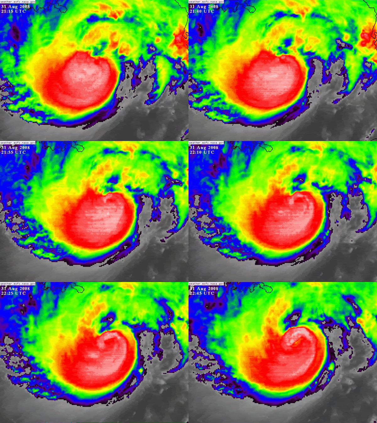
.gif of Gustav's approach to Cuba (posted by USTropics last night)

Notice the dry air slot before intensification north of Caymans. NOT saying is going to bomb cat 4/5, the SST's are not similar and other factors - just wanted to note the dry air similarity.

Image
0 likes   

HurricaneRobert
Category 3
Category 3
Posts: 812
Joined: Fri May 18, 2007 9:31 pm

Re: Cat. 3 Hurricane Gustav in Gulf of Mexico

#8903 Postby HurricaneRobert » Sun Aug 31, 2008 6:09 pm

For a Category 4 strike, those buildings held up really well.
0 likes   

User avatar
Ptarmigan
Category 5
Category 5
Posts: 5316
Joined: Wed Aug 16, 2006 9:06 pm

Re:

#8904 Postby Ptarmigan » Sun Aug 31, 2008 6:10 pm

Derek Ortt wrote:I am a little worried about the latest satellite images


Why so Derek? I heard on the local news that if Gustav slows down, it could hug the coast of Louisiana and move west towards Texas.
0 likes   

User avatar
hiflyer
S2K Supporter
S2K Supporter
Posts: 562
Joined: Wed Sep 08, 2004 11:24 am
Location: West Broward Florida

Re: Cat. 3 Hurricane Gustav in Gulf of Mexico

#8905 Postby hiflyer » Sun Aug 31, 2008 6:11 pm

Downdraft wrote:Ship 27.6 -85.6 C6CL6 measuring 78mph winds 115.75 nautical miles northeast of the center. Also reporting 11 meter waves every 2 seconds.


Ship is 800 feet long....almost 15kts speed when fully loaded....11 meter waves could be higher than the main deck if loaded down.
http://www.vulcanmaterials.com/ship/MV_ ... _Specs.pdf

Bet the 33 man crew is peddling away as fast as they can....hopefully successful.
0 likes   

User avatar
stormy1970al
Tropical Storm
Tropical Storm
Posts: 158
Age: 55
Joined: Sat May 31, 2008 12:54 pm
Location: Fairhope AL

Re: Cat. 3 Hurricane Gustav in Gulf of Mexico

#8906 Postby stormy1970al » Sun Aug 31, 2008 6:11 pm

We had our first feeder band here around 4:30-5pm. It was pretty nasty.
0 likes   

attallaman

Re: Cat. 3 Hurricane Gustav in Gulf of Mexico

#8907 Postby attallaman » Sun Aug 31, 2008 6:11 pm

Brent wrote:
attallaman wrote:It's starting to rain hard here in Biloxi, experiencing some squalls and gusty winds, lots of thunder, could this the beginning of Gustav for my area?


Yeah, it's Gustav. I just had a brief shower and gusty winds here and I'm 150 miles inland.
Your 150 miles inland, wow. I'm about 3 miles N of the GOM in flood zone "C" which fortunately was not included in the mandatory evacuation order for Harrison County, Mississippi last night, only flood zones "A" and "B" were in the order as well as residents living in FEMA trailers and Katrina cottages.
0 likes   

User avatar
HURAKAN
Professional-Met
Professional-Met
Posts: 46086
Age: 38
Joined: Thu May 20, 2004 4:34 pm
Location: Key West, FL
Contact:

#8908 Postby HURAKAN » Sun Aug 31, 2008 6:12 pm

Image
0 likes   

User avatar
Bunkertor
Category 5
Category 5
Posts: 3397
Joined: Tue May 09, 2006 3:48 pm

Re: Re:

#8909 Postby Bunkertor » Sun Aug 31, 2008 6:13 pm

THead wrote:
Bunkertor wrote:
HURAKAN wrote:Image

I don't see any dry air intrusion.


I hate to ask questions about the projected impact time but this pic suggests it could be earlier than 8 AM CDT...

Right ?


Theyre going to start getting impacted by squalls really soon. He is definitely coming in quick.

http://radar.weather.gov/ridge/radar.ph ... x&loop=yes


Will an arrival time before sunrise have a significantly "positive" effect concerning the strength ?
0 likes   

User avatar
Hurricanewatcher2007
Category 2
Category 2
Posts: 578
Joined: Sat Jul 05, 2008 8:10 pm

Re: Cat. 3 Hurricane Gustav in Gulf of Mexico

#8910 Postby Hurricanewatcher2007 » Sun Aug 31, 2008 6:13 pm

Now down to 952.8mb pressure from latest recon fix. Not sure what they will have on the VDM though.
0 likes   

RL3AO
Moderator-Pro Met
Moderator-Pro Met
Posts: 16308
Joined: Thu Jun 14, 2007 10:03 pm
Location: NC

#8911 Postby RL3AO » Sun Aug 31, 2008 6:13 pm

Recon data suggesting a more NNW-like movement in the past 90 minutes or so. Lets see where the VDM is.
0 likes   

User avatar
ConvergenceZone
Category 5
Category 5
Posts: 5194
Joined: Fri Jul 29, 2005 1:40 am
Location: Northern California

Re: Re:

#8912 Postby ConvergenceZone » Sun Aug 31, 2008 6:14 pm

Viper54r wrote:
Derek Ortt wrote:I am a little worried about the latest satellite images

Don't leave us hanging, Derek.


Derek likes to tease us and then run :)
0 likes   

THead
S2K Supporter
S2K Supporter
Posts: 790
Joined: Mon Aug 30, 2004 5:09 pm
Location: Lauderhill, Fla./Jefferson, Ga.

Re:

#8913 Postby THead » Sun Aug 31, 2008 6:14 pm


Wow, what a mess. And not just weak buildings either, seeing alot of heavy duty brick, and cbs constructed buildings wiped out.
0 likes   

KBBOCA
S2K Supporter
S2K Supporter
Posts: 1559
Joined: Fri Sep 05, 2003 5:27 am
Location: Formerly Boca Raton, often West Africa. Currently Charlotte NC

Re:

#8914 Postby KBBOCA » Sun Aug 31, 2008 6:14 pm


Thanks for the link to the story re: Cuba Hurakan. I was stunned by the reported windspeeds.

Officials measured gusts of 212 mph (340 kph) in the western town of Paso Real del San Diego — a new national record for maximum wind speed in a country often hit by major hurricanes, said Miguel Angel Hernandez of the Cuban Institute of Meteorology.

Yikes!

Does anyone have handy the highest reported windspeeds for US Landfalling hurricanes? Just curious. Glad Louisiana will be spared the wrath Cuba faced. And yet Gustav may still be a disastrous event for NOLA and other areas of Louisiana. Praying for all in Gustav's path.
0 likes   

User avatar
Cape Verde
Category 2
Category 2
Posts: 564
Age: 70
Joined: Tue Aug 31, 2004 5:53 pm
Location: Houston area

Re:

#8915 Postby Cape Verde » Sun Aug 31, 2008 6:15 pm

PTrackerLA wrote:Chances of me getting ANY sleep tonight virtually zero :lol: . Hopefully he doesn't get any stronger but that is a very menacing last visible. I've been talking to people in the city that are DOWNPLAYING the potential effects because "it's only a cat 3 with 115 winds." Big lesson about to be taught in south-central Louisiana. It's been DECADES since we've even had sustained cat 1 winds here and from reading what many of our great posters have reported having gone through with Wilma, Charley, Rita, Ivan, etc I'm braced for quite a blow.


What the heck are you talking about? I lived in Lafayette in 1992 and Andrew came right through with the eye about 9 miles from my house.

It was Cat 3 at the time.
0 likes   

BigB0882
S2K Supporter
S2K Supporter
Posts: 2284
Joined: Thu Jul 03, 2003 12:08 am
Location: Baton Rouge, LA
Contact:

Re: Re:

#8916 Postby BigB0882 » Sun Aug 31, 2008 6:15 pm

I hate to ask questions about the projected impact time but this pic suggests it could be earlier than 8 AM CDT...

Right ?[/quote]

Theyre going to start getting impacted by squalls really soon. He is definitely coming in quick.

http://radar.weather.gov/ridge/radar.ph ... x&loop=yes[/quote]

Will an arrival time before sunrise have a significantly "positive" effect concerning the strength ?[/quote]

It is a double edged sword. It is certainly good because the land will stop it from strengthening anymore but at the same time no one wants a strengthening hurricane at landfall.
0 likes   

PhillyWX
Category 1
Category 1
Posts: 494
Joined: Tue Aug 30, 2005 8:54 am
Location: Philly
Contact:

Re: Cat. 3 Hurricane Gustav in Gulf of Mexico

#8917 Postby PhillyWX » Sun Aug 31, 2008 6:15 pm

0 likes   

tolakram
Admin
Admin
Posts: 20012
Age: 62
Joined: Sun Aug 27, 2006 8:23 pm
Location: Florence, KY (name is Mark)

Re: Cat. 3 Hurricane Gustav in Gulf of Mexico

#8918 Postby tolakram » Sun Aug 31, 2008 6:15 pm

Image

Almost a full wrap, and this is happening over cooler (but still warm) water. Lets hope it's temporary and the dry air wins.

Hurakan, hope everyone in your family is OK, thanks for the pics.
0 likes   

User avatar
KWT
Category 5
Category 5
Posts: 31415
Joined: Tue Aug 17, 2004 11:02 am
Location: UK!!!

#8919 Postby KWT » Sun Aug 31, 2008 6:15 pm

NNW motion...thats really bad news for N.O if thats the truth, surely we aren't looking at a near dead on hit on the city? :eek:
0 likes   

shawn67
Tropical Storm
Tropical Storm
Posts: 143
Age: 58
Joined: Fri Jul 08, 2005 3:03 pm
Location: Fresno, CA

Re: Cat. 3 Hurricane Gustav in Gulf of Mexico

#8920 Postby shawn67 » Sun Aug 31, 2008 6:16 pm

According to the tropical atlantic overlay for google I am still showing the eye to be just east projected NHC position and 273 miles from NOLA does that jive with what everyone else is seeing?
Last edited by shawn67 on Sun Aug 31, 2008 6:17 pm, edited 1 time in total.
0 likes   


Return to “2008”

Who is online

Users browsing this forum: No registered users and 13 guests