ATL GUSTAV: Tropical Depression - Discussion

Moderator: S2k Moderators

Message
Author
User avatar
ConvergenceZone
Category 5
Category 5
Posts: 5194
Joined: Fri Jul 29, 2005 1:40 am
Location: Northern California

Re: Cat. 3 Hurricane Gustav in Gulf of Mexico

#8921 Postby ConvergenceZone » Sun Aug 31, 2008 6:16 pm

Finally, I might be able to get on board with the intensification phase...Last satellite shows wrapping around with the reds that I haven't seen since I awoke this morning.... Perhaps this is what Derek is worried about

http://www.ssd.noaa.gov/goes/flt/t1/avn-l.jpg


Doesn't that look like a fetus? ;) Look before it switches to a new frame...
Last edited by ConvergenceZone on Sun Aug 31, 2008 6:19 pm, edited 1 time in total.
0 likes   

BigB0882
S2K Supporter
S2K Supporter
Posts: 2284
Joined: Thu Jul 03, 2003 12:08 am
Location: Baton Rouge, LA
Contact:

Re:

#8922 Postby BigB0882 » Sun Aug 31, 2008 6:17 pm

RL3AO wrote:Recon data suggesting a more NNW-like movement in the past 90 minutes or so. Lets see where the VDM is.


Very very interesting and not good for me!
0 likes   

User avatar
terrapintransit
Category 1
Category 1
Posts: 275
Age: 50
Joined: Tue Sep 04, 2007 8:08 pm
Location: Williamsport, Pa

Re: Cat. 3 Hurricane Gustav in Gulf of Mexico

#8923 Postby terrapintransit » Sun Aug 31, 2008 6:17 pm


It seems the eye is very close to appearing..
0 likes   

User avatar
KWT
Category 5
Category 5
Posts: 31415
Joined: Tue Aug 17, 2004 11:02 am
Location: UK!!!

#8924 Postby KWT » Sun Aug 31, 2008 6:17 pm

Convection wrapping right around however note on the IR to the SE of the burst the cloud tops are warming...the eye is clearing out whilst convection deepens in the eyewall...Gustav is strengthening again on its run to landfall...
0 likes   

User avatar
Ivanhater
Storm2k Moderator
Storm2k Moderator
Posts: 11162
Age: 38
Joined: Fri Jul 01, 2005 8:25 am
Location: Pensacola

Re: Cat. 3 Hurricane Gustav in Gulf of Mexico

#8925 Postby Ivanhater » Sun Aug 31, 2008 6:18 pm

This is going to be a bad night for me and my neighbors on the central gulfcoast :(
0 likes   

User avatar
feederband
S2K Supporter
S2K Supporter
Posts: 3423
Joined: Wed Oct 01, 2003 6:21 pm
Location: Lakeland Fl

Re: Cat. 3 Hurricane Gustav in Gulf of Mexico

#8926 Postby feederband » Sun Aug 31, 2008 6:18 pm

ConvergenceZone wrote:Finally, I might be able to get on board with the intensification phase...Last satellite shows wrapping around with the reds that I haven't seen since I awoke this morning.... Perhaps this is what Derek is worried about

http://www.ssd.noaa.gov/goes/flt/t1/avn-l.jpg
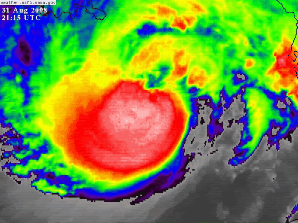
I could be wrong but thats what I thought he may be looking at as well..
0 likes   

User avatar
crazycajuncane
S2K Supporter
S2K Supporter
Posts: 1097
Joined: Sun Aug 15, 2004 2:51 pm
Location: Lafayette, Louisiana
Contact:

Re: Cat. 3 Hurricane Gustav in Gulf of Mexico

#8927 Postby crazycajuncane » Sun Aug 31, 2008 6:19 pm

Tropical showers on the local doppler radar. That's in Lafayette, LA and we are a long way from the center of Mr. Gustav!
0 likes   

User avatar
coriolis
Retired Staff
Retired Staff
Posts: 8314
Joined: Wed Feb 05, 2003 10:58 pm
Location: Muncy, PA

Re: Cat. 3 Hurricane Gustav in Gulf of Mexico

#8928 Postby coriolis » Sun Aug 31, 2008 6:19 pm

Earlier someone posted a link to the USGS water watch site.

http://water.usgs.gov/waterwatch/gustav/?#

If you click on some of those circles it gives you a popup with data in it. If you click the link in the popup it takes you to a page that gives graphical data for water levels. For instance:

http://waterdata.usgs.gov/nwis/uv/?site_no=073802338

USGS 073802338 IWW @ I-510 Bridge (Paris Rd) at New Orleans, LA
http://waterdata.usgs.gov/nwisweb/data/img/USGS.073802338.01.00065.2008.20080824.20080831.0.0..gif

It gives you a graph of the actual water level under that bridge. You can see the effect of the tides over the last few days. This would give an accurate indication of the storm surge when it gets there. It does have a delay of a couple hours though.
0 likes   

Dean4Storms
S2K Supporter
S2K Supporter
Posts: 6358
Age: 62
Joined: Sun Aug 31, 2003 1:01 pm
Location: Miramar Bch. FL

#8929 Postby Dean4Storms » Sun Aug 31, 2008 6:20 pm

Wow, come back a couple hours later and find EXPLOSION, this Sat imagery is very concerning. Looks to be deepening right before Landfall, not good. Also the more NNW movement would follow what Gustav has shown when he is sub 955mb so far. I think the deeper storm steps into the ridge harder.
Last edited by Dean4Storms on Sun Aug 31, 2008 6:21 pm, edited 1 time in total.
0 likes   

PhillyWX
Category 1
Category 1
Posts: 494
Joined: Tue Aug 30, 2005 8:54 am
Location: Philly
Contact:

Re: Cat. 3 Hurricane Gustav in Gulf of Mexico

#8930 Postby PhillyWX » Sun Aug 31, 2008 6:20 pm

terrapintransit wrote:


It seems the eye is very close to appearing..


Yes...this is the best it's looked today, IMO. It's really getting its act together. Wouldn't be surprised to see some modest strengthening before landfall.
0 likes   

User avatar
canetracker
S2K Supporter
S2K Supporter
Posts: 751
Age: 62
Joined: Wed Jul 27, 2005 8:49 pm
Location: Suburbia New Orleans...Harahan, LA

Re:

#8931 Postby canetracker » Sun Aug 31, 2008 6:21 pm

KWT wrote:NNW motion...thats really bad news for N.O if thats the truth, surely we aren't looking at a near dead on hit on the city? :eek:

Seriously gotta hate this NNW movement!!! Our local mets are staying optimistic in regards to intensity.
0 likes   

Dave C
S2K Supporter
S2K Supporter
Posts: 868
Joined: Thu Sep 04, 2003 4:36 pm
Location: Middleboro, Mass.(midway between Cape Cod and Boston)

#8932 Postby Dave C » Sun Aug 31, 2008 6:21 pm

That deep convection has obscured the eye from view. I got home from work at 5pm and just the last 2 hrs has produced much better symetric system. must sleep though, 5am start to the day awaits me :roll: :roll:
0 likes   

User avatar
Hurricanewatcher2007
Category 2
Category 2
Posts: 578
Joined: Sat Jul 05, 2008 8:10 pm

Re: Cat. 3 Hurricane Gustav in Gulf of Mexico

#8933 Postby Hurricanewatcher2007 » Sun Aug 31, 2008 6:21 pm

Image
0 likes   

User avatar
Downdraft
S2K Supporter
S2K Supporter
Posts: 906
Joined: Wed Oct 09, 2002 8:45 pm
Location: Sanford, Florida
Contact:

Re: Cat. 3 Hurricane Gustav in Gulf of Mexico

#8934 Postby Downdraft » Sun Aug 31, 2008 6:21 pm

hiflyer wrote:
Downdraft wrote:Ship 27.6 -85.6 C6CL6 measuring 78mph winds 115.75 nautical miles northeast of the center. Also reporting 11 meter waves every 2 seconds.


Ship is 800 feet long....almost 15kts speed when fully loaded....11 meter waves could be higher than the main deck if loaded down.
http://www.vulcanmaterials.com/ship/MV_ ... _Specs.pdf

Bet the 33 man crew is peddling away as fast as they can....hopefully successful.


What's more interesting is hurricane force over 100 miles from the center and two, buoys ahead of the storm show 84 degree water.
0 likes   

User avatar
terrapintransit
Category 1
Category 1
Posts: 275
Age: 50
Joined: Tue Sep 04, 2007 8:08 pm
Location: Williamsport, Pa

Re: Cat. 3 Hurricane Gustav in Gulf of Mexico

#8935 Postby terrapintransit » Sun Aug 31, 2008 6:22 pm

Hurricanewatcher2007 wrote:Image


Look @ the greens appearing around the center.
0 likes   

User avatar
jasons2k
Storm2k Executive
Storm2k Executive
Posts: 8245
Age: 51
Joined: Wed Jul 06, 2005 12:32 pm
Location: The Woodlands, TX

Re:

#8936 Postby jasons2k » Sun Aug 31, 2008 6:23 pm

*cough cough*

Can I bump this again in a few hours? J/K, but really in all seriousness, some really questioned this earlier today and I think it's clear now that Gutsav is getting his act together.

jasons wrote:I think people are jumping on the weakening bandwagon WAY TOO prematurely and this could be very dangerous.

If you look at the satellite presentation, Gutsav has clearly been undergoing a period of reorganization after dealing with the shear, and the winds have relaxed.

It's very very clear that the outflow pattern is imporving and the shear will be less of a hinderance now. The eyewall is reorganizing. Once the eyewall can fully close-off and become more circular, expect the pressure to drop and winds to pick-up again.

By later tonight, I suspect Gustav will look much better again. Not as strong as yesterday as we once feared, but it's definitely putting the pieces together to make another run at intensifying. Nobody should be celebrating or letting their guard down yet, I could not emphazise this enough right now. Be a little patient.
0 likes   

User avatar
CronkPSU
S2K Supporter
S2K Supporter
Posts: 2014
Joined: Sun Aug 07, 2005 10:44 pm
Location: Avalon Park, FL

Re: Cat. 3 Hurricane Gustav in Gulf of Mexico

#8937 Postby CronkPSU » Sun Aug 31, 2008 6:23 pm

Hurricanewatcher2007 wrote:Image


first time we have seen green in that picture today isn't it?
0 likes   

Dean4Storms
S2K Supporter
S2K Supporter
Posts: 6358
Age: 62
Joined: Sun Aug 31, 2003 1:01 pm
Location: Miramar Bch. FL

#8938 Postby Dean4Storms » Sun Aug 31, 2008 6:23 pm

Derek, what is the chance that this goes east of NO by any degree???
0 likes   

User avatar
cheezyWXguy
Category 5
Category 5
Posts: 6108
Joined: Mon Feb 13, 2006 12:29 am
Location: Dallas, TX

Re: Cat. 3 Hurricane Gustav in Gulf of Mexico

#8939 Postby cheezyWXguy » Sun Aug 31, 2008 6:23 pm

ah ha! the legendary fist of intenisification.
0 likes   

Matt-hurricanewatcher

Re: Cat. 3 Hurricane Gustav in Gulf of Mexico

#8940 Postby Matt-hurricanewatcher » Sun Aug 31, 2008 6:24 pm

As long as it is moving 14-16+ mph, then tchp is not as important. Cat4s can form over the north Atlantic at 30-32 north...In Alex 2004 was a pretty high north strong cat3. If this stalled then yes the northern gulf would slowly weaken it, but if it keeps moving up it should be able to strengthen. It has to do with more about shear and dry air.
0 likes   


Return to “2008”

Who is online

Users browsing this forum: No registered users and 7 guests