
Real rough on the first radar images show about a 315 degree track....or pretty much what the NHC advertised...passing SW of the city...and a little over 18 kts....
as per the Eglin AFB radar.
NOLA radar says more like 312.
ATL GUSTAV: Tropical Depression - Discussion
Moderator: S2k Moderators

Re: Cat. 3 Hurricane Gustav in Gulf of Mexico
Ivanhater wrote:This is going to be a bad night for me and my neighbors on the central gulfcoast
If he doesn't get back on a NW track soon, lots of people are going to be surprised when they wake up to Hurricane Force winds when the news outlets have all been screaming LA (and rightly so).
0 likes
-
NativeFloridaGirl

- S2K Supporter

- Posts: 93
- Joined: Sun Aug 29, 2004 7:07 am
- Location: In Exile In Lower Alabama
Re:
HURAKAN wrote:Slides of images of damages in Cuba:
http://www.telemundo51.com/slideshow/no ... etail.html
http://www.telemundo51.com/slideshow/no ... etail.html
Hurakan, Did your family come through the storm ok?
~Beth~
0 likes
-
ConvergenceZone
.gif)
- Category 5

- Posts: 5241
- Joined: Fri Jul 29, 2005 1:40 am
- Location: Northern California
Re: Cat. 3 Hurricane Gustav in Gulf of Mexico
this is the best it's looked today, IMO. It's really getting its act together. Wouldn't be surprised to see some modest strengthening before landfall.
PhillyWX, that last satellite photo you had is about an hour and 30 minutes old. It says 21:15. The latest I have is 22:45
0 likes
-
Hurricanewatcher2007

- Category 2

- Posts: 578
- Joined: Sat Jul 05, 2008 8:10 pm
Re: Cat. 3 Hurricane Gustav in Gulf of Mexico
CronkPSU wrote:Hurricanewatcher2007 wrote:
first time we have seen green in that picture today isn't it?

I am not sure. I really haven't been watching much today. After staying up all night last night I spent a good part of the day today sleeping! lol But I should be good for my 3rd all nighter in a row tonight!
Product: Air Force Vortex Message (URNT12 KNHC)
Transmitted: 31st day of the month at 23:20Z
Aircraft: Air Force Aircraft (Last 3 digits of the tail number are 304)
Storm Number & Year: 07L in 2008
Storm Name: Gustav (in the North Atlantic basin)
Mission Number: 22
Observation Number: 21
A. Time of Center Fix: 31st day of the month at 23:03:00Z
B. Center Fix Coordinates: 26°43'N 87°29'W (26.7167N 87.4833W)
B. Center Fix Location: 258 miles (415 km) to the S (184°) from Pensacola, FL, USA.
C. Minimum Height at Standard Level: 2,701m (8,862ft) at 700mb
D. Estimated (by SFMR or visually) Maximum Surface Wind: 78kts (~ 89.8mph)
E. Location of the Estimated Maximum Surface Wind: 9 nautical miles (10 statute miles) to the W (270°) of center fix
F. Maximum Flight Level Wind Inbound: From 53° at 79kts (From the NE at ~ 90.9mph)
G. Location of Maximum Flight Level Wind Inbound: 55 nautical miles (63 statute miles) to the WNW (302°) of center fix
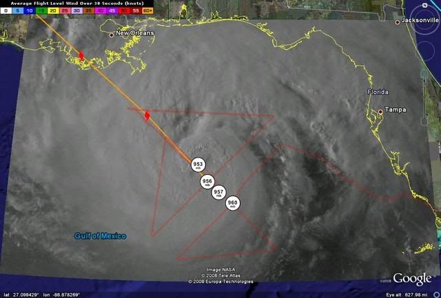
H. Minimum Sea Level Pressure: 953mb (28.14 inHg)
I. Maximum Flight Level Temp & Pressure Altitude Outside Eye: 7°C (45°F) at a pressure alt. of 3,059m (10,036ft)
J. Maximum Flight Level Temp & Pressure Altitude Inside Eye: 17°C (63°F) at a pressure alt. of 3,038m (9,967ft)
K. Dewpoint Temp (collected at same location as temp inside eye): 8°C (46°F)
K. Sea Surface Temp (collected at same location as temp inside eye): Not Available
L. Eye Character: Closed
M. Eye Shape: Elliptical (oval shaped)
M. Orientation of Major Axis in Elliptical Eye: 330° to 150° (NNW to SSE)
M. Length of Major Axis in Elliptical Eye: 40 nautical miles (46 statute miles)
M. Length of Minor Axis in Elliptical Eye: 25 nautical miles (29 statute miles)
N. Fix Determined By: Penetration, Radar, Wind, Pressure and Temperature
N. Fix Level: 700mb
O. Navigation Fix Accuracy: 0.02 nautical miles
O. Meteorological Accuracy: 2 nautical miles
Remarks Section:
Maximum Flight Level Wind: 97kts (~ 111.6mph) in the northeast quadrant at 21:00:30Z
Maximum Flight Level Wind Outbound: 90kts (~ 103.6mph) in the southeast quadrant at 23:08:20Z
Last edited by Hurricanewatcher2007 on Sun Aug 31, 2008 6:27 pm, edited 1 time in total.
0 likes

-
Stormcenter
- S2K Supporter
- Posts: 6689
- Joined: Wed Sep 03, 2003 11:27 am
- Location: Houston, TX
Re: Cat. 3 Hurricane Gustav in Gulf of Mexico
It still does not look anything like it did 24 hours ago (not saying anyone said that it did)
so I don't think we have to worried about that.
I still think it's fight dry air intrusion. JMHO
http://www.ssd.noaa.gov/goes/east/gmex/loop-wv.html
so I don't think we have to worried about that.
I still think it's fight dry air intrusion. JMHO
http://www.ssd.noaa.gov/goes/east/gmex/loop-wv.html
0 likes


-
ConvergenceZone
- Category 5
- Posts: 5241
- Joined: Fri Jul 29, 2005 1:40 am
- Location: Northern California
-
dixiebreeze

- S2K Supporter
- Posts: 5140
- Joined: Wed Sep 03, 2003 5:07 pm
- Location: crystal river, fla.
Re:
KWT wrote:Its really only a touch east of the NHC track mind you RL3AO but obviously at this stage small wobbles do make fairly big differences.
That classic east wobble at the 11th hour.
0 likes
-
Hurricanewatcher2007
- Category 2
- Posts: 578
- Joined: Sat Jul 05, 2008 8:10 pm
Re: Cat. 3 Hurricane Gustav in Gulf of Mexico
Stormcenter wrote:It still does not look anything like it did 24 hours ago (not saying anyone said that)
so I don't think we have to worried about that.
I still think it's fight dry air intrusion. JMHO
http://www.ssd.noaa.gov/goes/east/gmex/loop-wv.html
If you ask me thats a fight its quickly winning now! Eye is completely closed as of the latest VDM just released a couple minutes ago and the pressure continues to fall now down to 953mb. The winds may not have increased yet however with the pressure falling its just a matter of time before the winds start responding!
0 likes
-
Noles2006

- Category 1

- Posts: 424
- Joined: Thu Jun 08, 2006 9:57 am
- Location: Tallahassee, Florida
- Contact:
Re: Cat. 3 Hurricane Gustav in Gulf of Mexico
Stormcenter wrote:It still does not look anything like it did 24 hours ago (not saying anyone said that)
so I don't think we have to worried about that.
I still think it's fight dry air intrusion. JMHO
http://www.ssd.noaa.gov/goes/east/gmex/loop-wv.html
Stormcenter - let's see how Gustav looks in an hour or so... I've been on the "not going to strengthen" bandwagon all day... and recent satellite pictures, coupled with the recon report of a closed eyewall, have me very disturbed right now...
I think the intensifying is leading to Gustav moving more NNW as of late...
0 likes
-
superfly
Re: Cat. 3 Hurricane Gustav in Gulf of Mexico
Deep convection completely surrounds the warmer center now. I don't think it has the heat potential to deepen rapidly but I do expect steady strengthening to a high cat 3/low cat 4 now. The worst part is with the speed it's going at, it may landfall as a strengthening cane.
0 likes
-
Dean4Storms
- S2K Supporter
- Posts: 6358
- Age: 63
- Joined: Sun Aug 31, 2003 1:01 pm
- Location: Miramar Bch. FL
With the accelerated speed and deepening I'm concerned that the wobble could become a trend.
Last edited by Dean4Storms on Sun Aug 31, 2008 6:31 pm, edited 1 time in total.
0 likes
-
jlauderdal
- S2K Supporter
- Posts: 7240
- Joined: Wed May 19, 2004 5:46 am
- Location: NE Fort Lauderdale
- Contact:
Re: Cat. 3 Hurricane Gustav in Gulf of Mexico
i wouldn't want to be evacuating with those bands rolling onshore

Last edited by jlauderdal on Sun Aug 31, 2008 6:34 pm, edited 1 time in total.
0 likes
Re: Re:
dixiebreeze wrote:KWT wrote:Its really only a touch east of the NHC track mind you RL3AO but obviously at this stage small wobbles do make fairly big differences.
That classic east wobble at the 11th hour.
Ivan, Dennis, and Katrina all had the 11th hour 30-50 miles wobble.
0 likes
-
Hurricanewatcher2007
- Category 2
- Posts: 578
- Joined: Sat Jul 05, 2008 8:10 pm
Re:
KWT wrote:Its really only a touch east of the NHC track mind you RL3AO but obviously at this stage small wobbles do make fairly big differences.
It may not be very far off but I was listening to a press conference this afternoon and they were saying that just a little to the east could mean the difference between minor flooding and Major flooding for parts of N.O.
0 likes


Who is online
Users browsing this forum: No registered users and 8 guests