ATL GUSTAV: Tropical Depression - Discussion

Moderator: S2k Moderators

Message
Author
User avatar
Blown Away
S2K Supporter
S2K Supporter
Posts: 10152
Joined: Wed May 26, 2004 6:17 am

Re: Cat. 3 Hurricane Gustav in Gulf of Mexico

#8961 Postby Blown Away » Sun Aug 31, 2008 6:32 pm

Image[/quote]

If Gus follows those model tracks it seems he will be @50-60 miles from N.O., will they get sustained hurricane force winds? Sorry posted this in the models thread by accident.
0 likes   

User avatar
weatherman21
Tropical Depression
Tropical Depression
Posts: 67
Joined: Mon Apr 23, 2007 11:07 am

Re: Cat. 3 Hurricane Gustav in Gulf of Mexico

#8962 Postby weatherman21 » Sun Aug 31, 2008 6:33 pm

From what I have observed from the satellite images, Hurricane Gustav is acquiring intense convection on the north side of the low pressure center and the core is becoming better defined. Below are a few images from Unidata's Integrated Data Viewer:
Water Vapor Satellite Band at 22:55Z:
Image

Infrared Satellite Band at 22:55Z:
Image

Infrared Satellite Band; Zoomed at 22:55Z:
Image
0 likes   

User avatar
dixiebreeze
S2K Supporter
S2K Supporter
Posts: 5140
Joined: Wed Sep 03, 2003 5:07 pm
Location: crystal river, fla.

Re: Cat. 3 Hurricane Gustav in Gulf of Mexico

#8963 Postby dixiebreeze » Sun Aug 31, 2008 6:34 pm

I really worry that Mississippi may be in the mix now.
0 likes   

loro-rojo
Tropical Depression
Tropical Depression
Posts: 97
Joined: Tue Aug 08, 2006 7:11 pm
Location: San Juan, PR

Re: Cat. 3 Hurricane Gustav in Gulf of Mexico

#8964 Postby loro-rojo » Sun Aug 31, 2008 6:34 pm

It looks much more impressive than it has all day.

Image
0 likes   

tallywx
Category 2
Category 2
Posts: 790
Joined: Thu Jul 03, 2003 10:19 am
Location: Raleigh/Durham, NC

#8965 Postby tallywx » Sun Aug 31, 2008 6:35 pm

112 kts NE quad flight level winds, so she's a solid cat 3 now no matter how you cut it.
0 likes   

User avatar
KWT
Category 5
Category 5
Posts: 31415
Joined: Tue Aug 17, 2004 11:02 am
Location: UK!!!

#8966 Postby KWT » Sun Aug 31, 2008 6:35 pm

Deep convection blowing up in the eyewall, going to be so very interesting to watch in the next few hours and whether it holds the closed eyewall, if it does then we are going to see some strengthening happening.
0 likes   

User avatar
coriolis
Retired Staff
Retired Staff
Posts: 8314
Joined: Wed Feb 05, 2003 10:58 pm
Location: Muncy, PA

Re: Cat. 3 Hurricane Gustav in Gulf of Mexico

#8967 Postby coriolis » Sun Aug 31, 2008 6:36 pm

High tide will be right after noon tomorrow
0 likes   

User avatar
Hyperstorm
Category 5
Category 5
Posts: 1500
Joined: Sun Sep 07, 2003 3:48 am
Location: Ocala, FL

Re: Re:

#8968 Postby Hyperstorm » Sun Aug 31, 2008 6:37 pm

jasons wrote:*cough cough*

Can I bump this again in a few hours? J/K, but really in all seriousness, some really questioned this earlier today and I think it's clear now that Gutsav is getting his act together.

jasons wrote:I think people are jumping on the weakening bandwagon WAY TOO prematurely and this could be very dangerous.

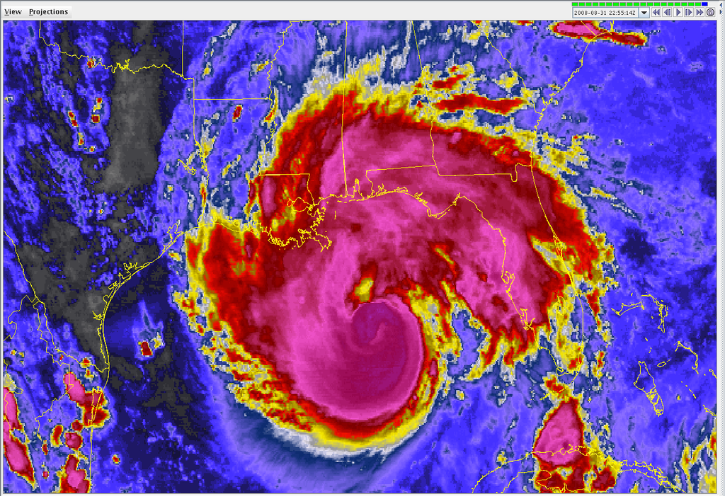
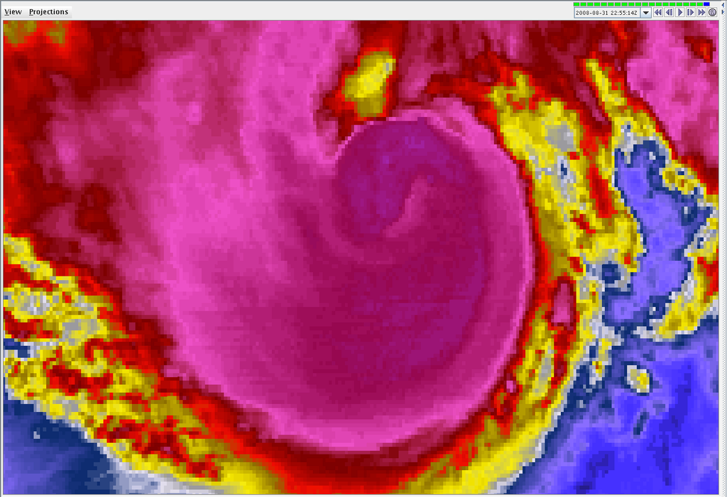
If you look at the satellite presentation, Gutsav has clearly been undergoing a period of reorganization after dealing with the shear, and the winds have relaxed.

It's very very clear that the outflow pattern is imporving and the shear will be less of a hinderance now. The eyewall is reorganizing. Once the eyewall can fully close-off and become more circular, expect the pressure to drop and winds to pick-up again.

By later tonight, I suspect Gustav will look much better again. Not as strong as yesterday as we once feared, but it's definitely putting the pieces together to make another run at intensifying. Nobody should be celebrating or letting their guard down yet, I could not emphazise this enough right now. Be a little patient.


As I mentioned earlier, the wind shear forecasts showed wind shear decreasing some during this time frame until early tomorrow. Hence, Gustav is taking advantage of the moment by showing an increase in FL winds that FINALLY support minimal CATEGORY 3 strength (It was clearly a Category 2 all day today, unofficially).

There is still shear there, though, so don't get too excited. I do think it has a chance to strengthen some, but should weaken again as it moves closer to the shore as wind shear is expected to increase again...
0 likes   

User avatar
dixiebreeze
S2K Supporter
S2K Supporter
Posts: 5140
Joined: Wed Sep 03, 2003 5:07 pm
Location: crystal river, fla.

Re:

#8969 Postby dixiebreeze » Sun Aug 31, 2008 6:37 pm

KWT wrote:Deep convection blowing up in the eyewall, going to be so very interesting to watch in the next few hours and whether it holds the closed eyewall, if it does then we are going to see some strengthening happening.


Yep. And the better the symmetry the more NNE and NE he appears.
0 likes   

O Town
S2K Supporter
S2K Supporter
Posts: 5205
Age: 52
Joined: Wed Sep 07, 2005 9:37 pm
Location: Orlando, Florida 28°35'35"N 81°22'55"W

#8970 Postby O Town » Sun Aug 31, 2008 6:37 pm

Image
0 likes   

User avatar
wxman57
Moderator-Pro Met
Moderator-Pro Met
Posts: 22983
Age: 67
Joined: Sat Jun 21, 2003 8:06 pm
Location: Houston, TX (southwest)

Re: Cat. 3 Hurricane Gustav in Gulf of Mexico

#8971 Postby wxman57 » Sun Aug 31, 2008 6:38 pm

No deviation from previous course. I just measured a 2-hr movement toward 302 degrees at 20 kts. Still racing along. That's heading for western Terrebonne parish, just as consensus models are saying.

6-hr movement 303 degrees at 16 kts.
Last edited by wxman57 on Sun Aug 31, 2008 6:40 pm, edited 1 time in total.
0 likes   

njweather
Tropical Storm
Tropical Storm
Posts: 169
Joined: Fri Aug 17, 2007 10:45 pm
Location: Washington, DC

Re: Cat. 3 Hurricane Gustav in Gulf of Mexico

#8972 Postby njweather » Sun Aug 31, 2008 6:38 pm

Yikes...

Will interaction will land affect this significantly?
0 likes   

BigB0882
S2K Supporter
S2K Supporter
Posts: 2284
Joined: Thu Jul 03, 2003 12:08 am
Location: Baton Rouge, LA
Contact:

Re: Cat. 3 Hurricane Gustav in Gulf of Mexico

#8973 Postby BigB0882 » Sun Aug 31, 2008 6:38 pm

dixiebreeze wrote:I really worry that Mississippi may be in the mix now.


Certainly not out of the question but it looks like it would have to head almost due N for that to happen. Not that it can't but I would think it is unlikely with the H to the East.
0 likes   

User avatar
wxman57
Moderator-Pro Met
Moderator-Pro Met
Posts: 22983
Age: 67
Joined: Sat Jun 21, 2003 8:06 pm
Location: Houston, TX (southwest)

Re: Cat. 3 Hurricane Gustav in Gulf of Mexico

#8974 Postby wxman57 » Sun Aug 31, 2008 6:39 pm

coriolis wrote:High tide will be right after noon tomorrow


I checked the Vermilion Bay/Atchafalaya Bay tides for tomorrow and there's only about an 8 inch difference between high and low tide, maybe less.
0 likes   

Stormcenter
S2K Supporter
S2K Supporter
Posts: 6684
Joined: Wed Sep 03, 2003 11:27 am
Location: Houston, TX

#8975 Postby Stormcenter » Sun Aug 31, 2008 6:39 pm

Folks this is still 115-120mph (nothing to sneeze at) hurricane it "should" look impressive.
I believe it's pretty safe to say it won't be what you saw yesterday.
0 likes   

BigB0882
S2K Supporter
S2K Supporter
Posts: 2284
Joined: Thu Jul 03, 2003 12:08 am
Location: Baton Rouge, LA
Contact:

Re: Cat. 3 Hurricane Gustav in Gulf of Mexico

#8976 Postby BigB0882 » Sun Aug 31, 2008 6:40 pm

coriolis wrote:High tide will be right after noon tomorrow


Is that good? I think it will make landfall 4-6 hours prior to noon.
0 likes   

User avatar
Sabanic
Category 2
Category 2
Posts: 683
Age: 65
Joined: Wed Aug 01, 2007 7:01 am
Location: Mobile, AL
Contact:

Re: Cat. 3 Hurricane Gustav in Gulf of Mexico

#8977 Postby Sabanic » Sun Aug 31, 2008 6:41 pm

BigB0882 wrote:
dixiebreeze wrote:I really worry that Mississippi may be in the mix now.


Certainly not out of the question but it looks like it would have to head almost due N for that to happen. Not that it can't but I would think it is unlikely with the H to the East.


Sorry but MS has been in the mix. They are on the N and E side of a hurricane with a very large wind field. Storm surge and Wind are both going to be bad for them even if Gus is going NW. We'll have very nasty weather here and we are 50 miles east of Biloxi alone.
0 likes   

AlabamaDave
Tropical Storm
Tropical Storm
Posts: 169
Joined: Wed Aug 11, 2004 6:44 pm

Re: Cat. 3 Hurricane Gustav in Gulf of Mexico

#8978 Postby AlabamaDave » Sun Aug 31, 2008 6:41 pm

TideJoe wrote:
Ivanhater wrote:This is going to be a bad night for me and my neighbors on the central gulfcoast :(


If he doesn't get back on a NW track soon, lots of people are going to be surprised when they wake up to Hurricane Force winds when the news outlets have all been screaming LA (and rightly so).


People need to listen to the NHC and not these TV goons. And the TV goons need to stop making armchair pronouncements in these types of situations. Most of them do not have the analytical skills or education of the NHC mets who are forecasting the storm.

Last time I checked, there is a Hurricane Warning all the way to the AL/FL state line. No one in the warning area should be too surprised by hurricane force winds. There's a reason that warning has been posted.
0 likes   

User avatar
dixiebreeze
S2K Supporter
S2K Supporter
Posts: 5140
Joined: Wed Sep 03, 2003 5:07 pm
Location: crystal river, fla.

Re: Cat. 3 Hurricane Gustav in Gulf of Mexico

#8979 Postby dixiebreeze » Sun Aug 31, 2008 6:42 pm

Listened to Gov. Bobby Jindal's summary of evac, etc. and what a vast difference this event is from Katrina when everyone was running in 10 directions with feet nailed in the floor.

Prayers up for all those in the north gulf coast.
0 likes   

User avatar
Tom8
Tropical Storm
Tropical Storm
Posts: 195
Joined: Sun Aug 19, 2007 4:36 pm
Location: Poland,Slupsk
Contact:

Re: Cat. 3 Hurricane Gustav in Gulf of Mexico

#8980 Postby Tom8 » Sun Aug 31, 2008 6:42 pm

Image
0 likes   


Return to “2008”

Who is online

Users browsing this forum: No registered users and 2 guests