ATL GUSTAV: Tropical Depression - Discussion
Moderator: S2k Moderators

Re: Cat 3 Hurricane Gustav in Gulf of Mexico
Not sure exactly what is happening in the northeast quadrant, but I appreciate whatever it is. Looks like subsidence (sinking air), which should be located only within the eye. That may be what is preventing rapid deepening.
0 likes
-
Enzo Aquarius

- Tropical Storm

- Posts: 160
- Joined: Wed Jul 23, 2008 12:53 pm
- Location: Canada
Re: Cat 3 Hurricane Gustav in Gulf of Mexico
GoneBabyGone wrote:Wind picking up in baton rouge. Clouds look ominous.
That outer band that caused the tornado warnings is going through Baton Rouge right now. So be expecting some rain, wind and lightning over the next half hour or so.
0 likes
-
soonertwister
- Category 5

- Posts: 1091
- Joined: Mon Jun 16, 2003 2:52 pm
Re: Cat 3 Hurricane Gustav in Gulf of Mexico
masaji79 wrote:At 115mph looks like Gustav will be the strongest landfalling US hurricane since Wilma in 2005.
Gustav is at 120 mph right now.
0 likes
-
Stormcenter
- S2K Supporter

- Posts: 6689
- Joined: Wed Sep 03, 2003 11:27 am
- Location: Houston, TX
Re:
HURAKAN wrote:
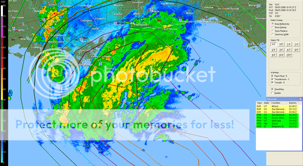
Eye becoming more visible in radar.

What is the link to that loop.....many thanks.
0 likes

Is that an eye popping out in the last frame? If you check mark the trop forecast points to the new eye, it's very clearly going east of track and making a beeline to New Orleans.
http://www.ssd.noaa.gov/goes/flt/t1/loop-wv.html
http://www.ssd.noaa.gov/goes/flt/t1/loop-wv.html
0 likes
-
pablolopez26
- Tropical Storm
- Posts: 137
- Joined: Wed Aug 27, 2008 5:10 pm
-
Cape Verde

- Category 2

- Posts: 564
- Age: 70
- Joined: Tue Aug 31, 2004 5:53 pm
- Location: Houston area
Re: Cat. 3 Hurricane Gustav in Gulf of Mexico
wxman57 wrote:I believe that the eye was last measured at about 25 miles across. It's a large area of relatively light winds. The plane flies around in there and tries to find a center of lowest pressure. That center may not be in the center of the 25 mile diameter ring. And the next time they fly through they may estimate a center in a different part of the eye. So you can't connect two VDMs and get a heading. They'll jump left and right of the actual track, depending upon where the plane fixes the lower pressure center each pass. The VDM does not identify the center of the eye (at least, not necessarily).
That was a very understandable post from a pro met at this forum, and I appreciate it as I"m sure others do too.
We all value the pro mets here, but sometimes they are only talking to each other, like doctors or lawyers, using terminology that laymen don't fully comprehend.
Don't be afraid to dumb it down for the rest of us! We're not stupid, but we don't all have the training.
Thank you.
0 likes
-
Enzo Aquarius
- Tropical Storm
- Posts: 160
- Joined: Wed Jul 23, 2008 12:53 pm
- Location: Canada
Re: Re:
Stormcenter wrote:HURAKAN wrote:
Eye becoming more visible in radar.
What is the link to that loop.....many thanks.
http://radar.weather.gov/radar.php?rid= ... 1&loop=yes
0 likes
-
Ivanhater

- Storm2k Moderator

- Posts: 11221
- Age: 39
- Joined: Fri Jul 01, 2005 8:25 am
- Location: Pensacola
Re: Cat 3 Hurricane Gustav in Gulf of Mexico
Radar continues to show a more NNW motion...I dont see how this goes west of NO
0 likes
-
marciacubed
- S2K Supporter
- Posts: 122
- Joined: Tue Jul 22, 2003 11:52 am
- Location: Boynton Beach, Fl
- Contact:
Re: Cat. 3 Hurricane Gustav in Gulf of Mexico
That was a very understandable post from a pro met at this forum, and I appreciate it as I"m sure others do too.
We all value the pro mets here, but sometimes they are only talking to each other, like doctors or lawyers, using terminology that laymen don't fully comprehend.
Don't be afraid to dumb it down for the rest of us! We're not stupid, but we don't all have the training.
Thank you.[/quote]
I loved that you stated that beautifully!!!
0 likes
-
superfly
Re:
mathwhizz wrote:Is that an eye popping out in the last frame? If you check mark the trop forecast points to the new eye, it's very clearly going east of track and making a beeline to New Orleans.
http://www.ssd.noaa.gov/goes/flt/t1/loop-wv.html
That's dry air.
0 likes
-
chris_fit

- Category 5
- Posts: 3261
- Age: 43
- Joined: Wed Sep 10, 2003 11:58 pm
- Location: Tampa Bay Area, FL
Re: Cat 3 Hurricane Gustav in Gulf of Mexico
Ivanhater wrote:Radar continues to show a more NNW motion...I dont see how this goes west of NO
Too far out to use radar...
0 likes
-
Stormcenter
- S2K Supporter
- Posts: 6689
- Joined: Wed Sep 03, 2003 11:27 am
- Location: Houston, TX
Re: Cat 3 Hurricane Gustav in Gulf of Mexico
Ivanhater wrote:Radar continues to show a more NNW motion...I dont see how this goes west of NO
I'm not seeing it but I'm no radar expert.
http://radar.weather.gov/radar.php?prod ... X&loop=yes
0 likes
-
Just Joshing You

- Category 2
- Posts: 512
- Joined: Sat Nov 03, 2007 10:29 am
- Location: Nova Scotia
Re: Cat 3 Hurricane Gustav in Gulf of Mexico
Looking at Landfall, and from what I remembered, didn't Katrina only give sustained wings of cat 1 and gusts of cat 2 in N.O? It looks like N.O will get the full brunt of Gustavs winds though, probably Cat 2 sustained, cat 3/4 gusts.
0 likes
-
Enzo Aquarius
- Tropical Storm
- Posts: 160
- Joined: Wed Jul 23, 2008 12:53 pm
- Location: Canada
Re: Cat 3 Hurricane Gustav in Gulf of Mexico
Tornado watches are now up for Louisiana, Mississippi, and Alabama.
0 likes
-
Cape Verde
- Category 2
- Posts: 564
- Age: 70
- Joined: Tue Aug 31, 2004 5:53 pm
- Location: Houston area
Re:
pablolopez26 wrote:Do you guys think that we'll get some rain out of this event here in Houston?
Probably not at landfall, but be careful what you wish for. The storm is poised to bounce back after it comes inland and dump a lot of water, probably on you.
0 likes
-
hurrican19
- Tropical Storm
- Posts: 153
- Joined: Sun Jun 13, 2004 1:36 pm
- Location: Northwest Austin, TX
I have not left, and most likely won't be leaving...
From KFDM in Beaumont:
(7:05PM Sunday) FROM THE KFDM WEATHER CENTER, New Data Indicates Gustav Expected to Make Landfall Well East of Golden Triangle.
KFDM Chief Meteorlogist Greg Bostwick says based on the most recent data, Hurricane Gustav is back on track after a brief wobble to the west earlier Sunday.
The center of Gustav is now located near 26.9 north and 87.7 west. Highest winds are 115 miles per hour. The motion is to the northwest at about 17 miles per hour.
"I am very confident now of a landfall well to our east, in an area just southwest of Houma, Louisiana, between about 9 a.m. and noon Monday, with winds of 120-125 miles per hour," said Greg.
"With landfall expected to be well to our east, winds locally likely won't exceed 40 miles per hour Monday night into Tuesday morning. That will be mainly near Sabine Lake and along the Sabine River. Rainfall totals shouldn't be very heavy, with amounts likely to remain less than two inches between Monday and Tuesday."
We'll continue monitoring Gustav for any changes that might occur before landfall.
Stay with KFDM News and Weather for the latest on Hurricane Gustav.
Last edited by hurrican19 on Sun Aug 31, 2008 8:53 pm, edited 1 time in total.
0 likes
-
jlauderdal
- S2K Supporter
- Posts: 7240
- Joined: Wed May 19, 2004 5:46 am
- Location: NE Fort Lauderdale
- Contact:
-
RainWind
Re: Cat 3 Hurricane Gustav in Gulf of Mexico
Ivanhater wrote:Radar continues to show a more NNW motion...I dont see how this goes west of NO
Yeah..... I keep watching it and if that 'empty circle' in the radar is the eye, it's moving NNW. New Orleans is going to get hammered and the MS coast is going to get stronger than anticipated surge and wind. I hope everyone got out in time.
0 likes
Who is online
Users browsing this forum: No registered users and 5 guests