
Here is a web cam from Galliano, LA (lower Lafourche)
http://www.ustream.tv/channel/crosby-tugs---gustav
Its facing hwy 3235.
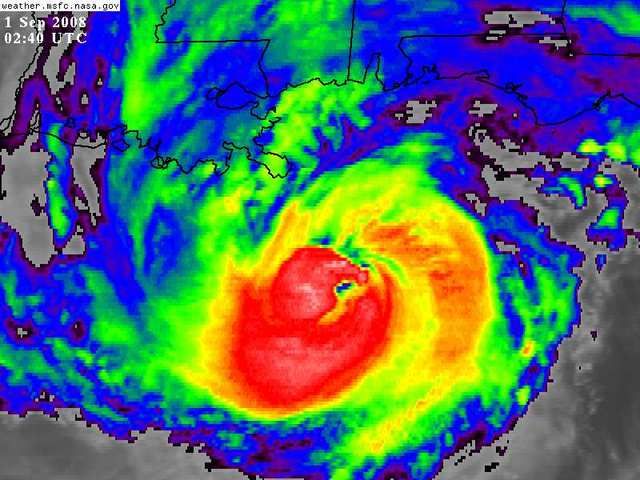
ATL GUSTAV: Tropical Depression - Discussion
Moderator: S2k Moderators

-
KBBOCA
- S2K Supporter

- Posts: 1559
- Joined: Fri Sep 05, 2003 5:27 am
- Location: Formerly Boca Raton, often West Africa. Currently Charlotte NC
Re:
RainWind wrote:Does anyone know where one could go to get current, live wind reports for the Baton Rouge area?
Here you go:
http://www.srh.noaa.gov/data/obhistory/KBTR.html
0 likes
-
Stormcenter
- S2K Supporter
- Posts: 6685
- Joined: Wed Sep 03, 2003 11:27 am
- Location: Houston, TX
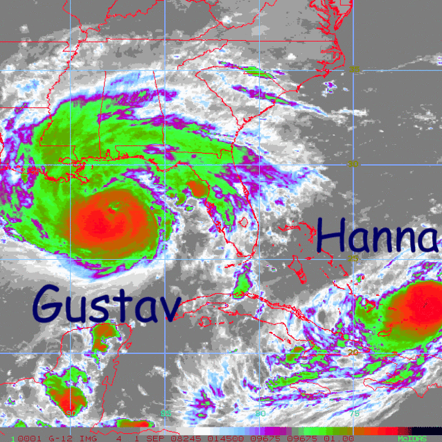
Re: Cat 3 Hurricane Gustav in Gulf of Mexico
Normandy wrote:ConvergenceZone,
I actually think it has a better chance of becoming a Category 4 hurricane than weakening the a borderline 1 or 2. Steady state, possibly slight intensification before landfall. For sure a major though I think.
I don't know about. He's not looking good at all.
0 likes

Re: Cat 3 Hurricane Gustav in Gulf of Mexico
Enzo Aquarius wrote:Ed Mahmoud wrote:Looks ugly coming up from Plaquemines Parish...
Almost at New Orleans....
Even if I can go back, I don't think I can. I am physically ill right now watching the radar, with the outbands going right over my home in Plaquemines Parish. I think I'll have to turn this off when the eye gets closer.
0 likes


Re: Cat 3 Hurricane Gustav in Gulf of Mexico
The new convective bursts in the N and E eyewall confirm my suspicions of no weakening until landfall.
0 likes


Re: Cat 3 Hurricane Gustav in Gulf of Mexico
Someone was saying this wouldn't be worse than Katrina for New Orleans, and talking about storm surge. A weatherman on WDSU or Channel 6 NOLA explained that the storm surge into NOLA would be 5 ft., but piled on top of that are the 26' waves that the storm will be pushing into the river and canals.
I don't know if he's correct, but if someone can speak to this, please do so.
I don't know if he's correct, but if someone can speak to this, please do so.
0 likes


-
Wthrman13

- Professional-Met

- Posts: 502
- Joined: Sun Jul 06, 2003 12:44 pm
- Location: West Lafayette, IN
- Contact:
Re: Re:
MHurricanes wrote:HURAKAN wrote:
Dangerous siblings.
Hurakan,
Thanks for all the great posts. I suppose I'm getting addicted to this great site.
I have suggested that many good people tend to romanticize hurricanes. Most of those folks have not experienced one -- or two or three. Which brings me to my point: It would be great to hear from a few people who have survived, or at least endured, Nature's thumb in the eye.
- MHurricanes
While I certainly don't want to romanticize hurricanes, nevertheless, for a meteorologist like myself, watching one in action is fascinating, especially if I'm part of an effort to study it scientifically. This is why I have volunteered when I can for hurricane intercepts with Doppler-on-Wheels (DOW) missions (I was in Isabel in 2003 and Frances in 2004). Obviously this is nothing like those who actually live in a hurricane-prone area and have to pick up the pieces after one strikes, but at the very least I can relate to the actual hurricane experience itself. For me it was at times awe-inspiring, and at other times, grueling. At any rate it is something I will never forget.
0 likes
-
Dean4Storms
- S2K Supporter
- Posts: 6358
- Age: 62
- Joined: Sun Aug 31, 2003 1:01 pm
- Location: Miramar Bch. FL
Re:
RainWind wrote:Does anyone know where one could go to get current, live wind reports for the Baton Rouge area?
Try here Rainwind.......
http://www.wunderground.com/weatherstat ... ted+States
0 likes


Re: Cat 3 Hurricane Gustav in Gulf of Mexico
my cursory look at new orleans and mobile radar seems to make it look like the eye has become elongated to the westsouthwest. This may be why the eye is open to the south too. And may be a leading indicator of a turn more to the west.
http://radar.weather.gov/radar.php?prod ... X&loop=yes
http://radar.weather.gov/radar.php?prod ... B&loop=yes
http://radar.weather.gov/radar.php?prod ... X&loop=yes
http://radar.weather.gov/radar.php?prod ... B&loop=yes
0 likes
-
Ed Mahmoud
Re: Cat 3 Hurricane Gustav in Gulf of Mexico
Is the DOW deploying for hurricane intercepts this season?
0 likes
-
Weatherfreak000

http://www.srh.weather.gov/data/obhistory/KBVE.html
Starting to get ugly in Boothvill La.. winds 30 gusting to 47s. Press 1004
Starting to get ugly in Boothvill La.. winds 30 gusting to 47s. Press 1004
Last edited by capepoint on Sun Aug 31, 2008 10:06 pm, edited 1 time in total.
0 likes
-
wxman57

- Moderator-Pro Met

- Posts: 23096
- Age: 68
- Joined: Sat Jun 21, 2003 8:06 pm
- Location: Houston, TX (southwest)
Re:
Weatherfreak000 wrote:Good call Wxman....that's exactly NW on track.
No wind upgrade? What? despite the obvious recon data? Whats up with that?
Recon data showed rising pressure and surface winds 100 kts. That's not strengthening. Going to bed now. I'll sleep better with Gustav NOT strengthening and NOT hitting my mother in Mississippi (who got flooded with Katrina). However, my sister is on vacation in Arizona and she lives south of Baton Rouge. They'll lose all their food in 2 freezers since they don't return until next weekend.
Last edited by wxman57 on Sun Aug 31, 2008 10:06 pm, edited 1 time in total.
0 likes

 Y'all confuse people waaaay too much!
Who is online
Users browsing this forum: No registered users and 68 guests