


ATL GUSTAV: Tropical Depression - Discussion
Moderator: S2k Moderators
Re: Cat 3 Hurricane Gustav in Gulf of Mexico
Last edited by ekal on Sun Aug 31, 2008 10:06 pm, edited 1 time in total.
0 likes

-
wxman57

- Moderator-Pro Met

- Posts: 23096
- Age: 68
- Joined: Sat Jun 21, 2003 8:06 pm
- Location: Houston, TX (southwest)
Re:
CajunMama wrote:well ya know i feel so safe now. Gus is weakening as he moves more north while strengthening and then doing a loop-de-loop while moving more west doing the do-si-do all the while dating fay's niece's sisters moms aunt.Y'all confuse people waaaay too much!
Batten down the hatches there CajunMama. New track is directly over Lafayette (my home town). Lafayette hasn't seen a hurricane this strong in quite a while pass directly overhead.
0 likes

000
WTNT32 KNHC 010253
TCPAT2
BULLETIN
HURRICANE GUSTAV ADVISORY NUMBER 30
NWS TPC/NATIONAL HURRICANE CENTER MIAMI FL AL072008
1000 PM CDT SUN AUG 31 2008
...GUSTAV CLOSING IN ON THE NORTHERN GULF COAST...
A HURRICANE WARNING REMAINS IN EFFECT FROM JUST EAST OF HIGH ISLAND
TEXAS EASTWARD TO THE ALABAMA-FLORIDA BORDER...INCLUDING THE CITY
OF NEW ORLEANS AND LAKE PONTCHARTRAIN. PREPARATIONS TO PROTECT LIFE
AND PROPERTY SHOULD BE RUSHED TO COMPLETION.
A TROPICAL STORM WARNING REMAINS IN EFFECT FROM EAST OF THE
ALABAMA-FLORIDA BORDER TO THE OCHLOCKONEE RIVER.
FOR STORM INFORMATION SPECIFIC TO YOUR AREA...INCLUDING POSSIBLE
INLAND WATCHES AND WARNINGS...PLEASE MONITOR PRODUCTS ISSUED
BY YOUR LOCAL WEATHER OFFICE.
AT 1000 PM CDT...0300Z...THE CENTER OF HURRICANE GUSTAV WAS LOCATED
NEAR LATITUDE 27.3 NORTH...LONGITUDE 88.1 WEST OR ABOUT 220 MILES...
360 KM...SOUTHEAST OF NEW ORLEANS LOUISIANA AND ABOUT 310 MILES...
500 KM...SOUTHEAST OF LAFAYETTE LOUISIANA. THIS POSITION IS ALSO
ABOUT 180 MILES...285 KM...SOUTHEAST OF PORT FOURCHON ALONG THE
LOUISIANA COAST.
GUSTAV IS MOVING TOWARD THE NORTHWEST NEAR 16 MPH...26 KM/HR...AND
THIS MOTION IS EXPECTED TO CONTINUE PRIOR TO LANDFALL. ON THE
FORECAST TRACK...THE CENTER OF GUSTAV WOULD REACH THE NORTHERN GULF
COAST DURING THE DAYLIGHT HOURS TOMORROW. A DECREASE IN FORWARD
SPEED IS EXPECTED TO OCCUR ON TUESDAY.
MAXIMUM SUSTAINED WINDS ARE NEAR 115 MPH...185 KM/HR...WITH HIGHER
GUSTS. GUSTAV IS A CATEGORY THREE HURRICANE ON THE SAFFIR-SIMPSON
SCALE. A LITTLE STRENGTHENING IS POSSIBLE PRIOR TO LANDFALL.
GUSTAV IS A LARGE TROPICAL CYCLONE. HURRICANE FORCE WINDS EXTEND
OUTWARD UP TO 70 MILES...110 KM...FROM THE CENTER...AND TROPICAL
STORM FORCE WINDS EXTEND OUTWARD UP TO 220 MILES...350 KM.
THE LATEST MINIMUM CENTRAL PRESSURE ESTIMATED FROM NOAA AIRCRAFT
RECONNAISSANCE DATA WAS 954 MB...28.17 INCHES.
AN EXTREMELY DANGEROUS STORM SURGE OF 10 TO 14 FEET ABOVE NORMAL
TIDAL LEVELS IS EXPECTED NEAR AND TO THE EAST OF WHERE THE CENTER
OF GUSTAV CROSSES THE COAST.
GUSTAV IS EXPECTED TO PRODUCE TOTAL RAINFALL ACCUMULATIONS OF 6 TO
12 INCHES OVER PORTIONS OF LOUISIANA...SOUTHERN AND WESTERN
MISSISSIPPI...ARKANSAS AND NORTHEASERN TEXAS...WITH ISOLATED
MAXIMUM AMOUNTS OF UP TO 20 INCHES POSSIBLE THROUGH WEDNESDAY.
ISOLATED TORNADOES ARE POSSIBLE OVER THE CENTRAL GULF COAST TONIGHT.
REPEATING THE 1000 PM CDT POSITION...27.3 N...88.1 W. MOVEMENT
TOWARD...NORTHWEST NEAR 16 MPH. MAXIMUM SUSTAINED WINDS...115 MPH.
MINIMUM CENTRAL PRESSURE...954 MB.
AN INTERMEDIATE ADVISORY WILL BE ISSUED BY THE NATIONAL HURRICANE
CENTER AT 100 AM CDT FOLLOWED BY THE NEXT COMPLETE ADVISORY AT 400
AM CDT.
$$
FORECASTER FRANKLIN
Last edited by Bunkertor on Sun Aug 31, 2008 10:09 pm, edited 1 time in total.
0 likes
-
O Town
- S2K Supporter

- Posts: 5205
- Age: 52
- Joined: Wed Sep 07, 2005 9:37 pm
- Location: Orlando, Florida 28°35'35"N 81°22'55"W
Re:
CajunMama wrote:well ya know i feel so safe now. Gus is weakening as he moves more north while strengthening and then doing a loop-de-loop while moving more west doing the do-si-do all the while dating fay's niece's sisters moms aunt.
Ya think?
0 likes
-
mattpetre
- Category 2

- Posts: 510
- Age: 53
- Joined: Mon Sep 19, 2005 3:20 pm
- Location: Missouri City,TX & Galleria
- Contact:
Re:
Nexus wrote:
Looks like a more classical eye may be developing before landfall... don't know what this means other than it may stop some tracking confusion if it occurs. This has done in intensity things that Fay did in path, what a strange season.
0 likes
-
tolakram
- Admin

- Posts: 20167
- Age: 62
- Joined: Sun Aug 27, 2006 8:23 pm
- Location: Florence, KY (name is Mark)
Re: Cat 3 Hurricane Gustav in Gulf of Mexico
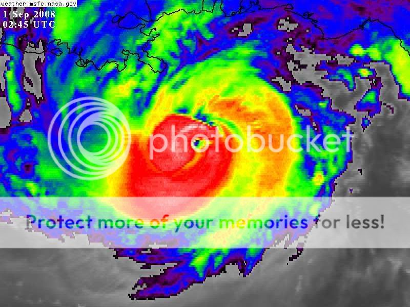
Animated image:
http://weather.msfc.nasa.gov/cgi-bin/ge ... olor=white
Another round of convection appears to be building around the eye again.
http://weather.msfc.nasa.gov/cgi-bin/ge ... olor=white
Another round of convection appears to be building around the eye again.
0 likes
Re: Cat 3 Hurricane Gustav in Gulf of Mexico
FWIW, we may see the first issuance of the extreme wind warning product (replaces the practice of issuing tornado warnings for the counties being affected by the eyewall of a landfalling major hurricane). I think the threshold for an EWW is 120 mph sustained.
0 likes


-
southerngale

- Retired Staff

- Posts: 27418
- Joined: Thu Oct 10, 2002 1:27 am
- Location: Southeast Texas (Beaumont area)
Re: Cat 3 Hurricane Gustav in Gulf of Mexico
Enzo Aquarius wrote:southerngale wrote:wxman57 wrote:Is there ANY WAY to turn off this "New Post Review" feature? I can't even reply to a message here any more tonight as each time I hit "Submit" it tells me that a new post has been made while I was typing and asks if I want to read it before replying. Took me 20 hits of "Submit" last time to get my post in. You people are posting too fast to let a new message in.
We'll check into it.
Thank you, it can be, indeed, annoying.
I agree. Unfortunately, it's not something we can just disable. Chad has put in a modification request for it, but we don't know how long that takes.
0 likes
Re: Cat 3 Hurricane Gustav in Gulf of Mexico
Ed Mahmoud wrote:Is the DOW deploying for hurricane intercepts this season?
Don't think so:
http://www.cswr.org/projects/rotate/rotate2008.php
0 likes
-
ConvergenceZone
.gif)
- Category 5

- Posts: 5241
- Joined: Fri Jul 29, 2005 1:40 am
- Location: Northern California
It is kinda cool to FINALLY see the eye for the first time today
http://www.ssd.noaa.gov/goes/flt/t1/avn-l.jpg
and no, it's not the dry slot. It popped out nice and clear on this last shot...
http://www.ssd.noaa.gov/goes/flt/t1/avn-l.jpg
and no, it's not the dry slot. It popped out nice and clear on this last shot...
0 likes
-
CrazyC83
- Professional-Met

- Posts: 34307
- Joined: Tue Mar 07, 2006 11:57 pm
- Location: Deep South, for the first time!
Re: Cat 3 Hurricane Gustav in Gulf of Mexico
Personal Forecast Disclaimer:
The posts in this forum are NOT official forecast and should not be used as such. They are just the opinion of the poster and may or may not be backed by sound meteorological data. They are NOT endorsed by any professional institution or storm2k.org. For official information, please refer to the NHC and NWS products.
This is my thoughts on the best track so far:
Time Lat Long Winds Pres
• 25/0600 14.5 68.5 30 1007 Tropical depression
• 25/1200 15.3 69.5 40 1003 Tropical storm
• 25/1800 15.6 70.5 50 996
• 26/0000 16.3 71.1 60 993
• 26/0600 16.9 71.6 75 986 Hurricane
• 26/1200 17.6 72.2 80 981
• 26/1800 18.2 72.8 70 983
• 27/0000 18.4 73.1 60 992 Tropical storm
• 27/0600 18.6 73.3 50 997
• 27/1200 18.7 73.6 45 997
• 27/1800 18.9 74.0 40 999
• 28/0000 18.7 74.9 35 998
• 28/0600 18.1 75.4 50 990
• 28/1200 17.9 75.7 60 985
• 28/1800 18.0 76.2 65 983 Hurricane
• 29/0000 17.8 76.9 60 987 Tropical storm
• 29/0600 17.9 77.6 55 991
• 29/1200 18.3 78.4 60 987
• 29/1800 18.8 79.2 65 984 Hurricane
• 30/0000 19.2 80.0 75 974
• 30/0600 19.7 80.8 85 966
• 30/1200 20.7 81.6 110 954
• 30/1800 21.6 82.6 125 942
• 31/0000 22.7 83.4 110 947
• 31/0600 23.6 84.4 100 958
• 31/1200 24.8 85.5 95 961
• 31/1800 25.9 86.7 100 957
• 31/1800 26.9 88.2 105 950
Landfalls
• 26/1500 17.9 72.6 80 980 Haiti landfall
• 28/1800 18.0 76.2 65 983 Jamaica landfall
• 30/1700 21.3 82.4 125 944 Isle of Youth landfall
• 30/2200 22.3 83.2 125 941 Western Cuba landfall
0 likes
-
Category 5

- Category 5
- Posts: 10074
- Age: 35
- Joined: Sun Feb 11, 2007 10:00 pm
- Location: New Brunswick, NJ
- Contact:
Re:
ConvergenceZone wrote:It is kinda cool to FINALLY see the eye for the first time today
http://www.ssd.noaa.gov/goes/flt/t1/avn-l.jpg
and no, it's not the dry slot. It popped out nice and clear on this last shot...
Yeah, it appears Gustav is trying to make a final push. Hopefully it fails.
I hope everyone is evacuated, it's going to be a long 24 hours.
0 likes
-
CYCLONE MIKE
- Category 5
- Posts: 2183
- Joined: Tue Aug 31, 2004 6:04 pm
- Location: Gonzales, LA
Re: Cat 3 Hurricane Gustav in Gulf of Mexico
Eye looks even better on this loop. http://weather.msfc.nasa.gov/GOES/goeseastconusir.html
Last edited by CYCLONE MIKE on Sun Aug 31, 2008 10:23 pm, edited 2 times in total.
0 likes

-
LSU2001

- S2K Supporter
- Posts: 1711
- Age: 58
- Joined: Sat Sep 11, 2004 11:01 pm
- Location: Cut Off, Louisiana
Re: Cat 3 Hurricane Gustav in Gulf of Mexico
CYCLONE MIKE wrote:Eye looks even better on this loop. http://weather.msfc.nasa.gov/cgi-bin/post-goes
Linky no worky
tim
0 likes
-
HarlequinBoy

- Category 5
- Posts: 1400
- Age: 35
- Joined: Wed Nov 29, 2006 1:57 am
- Location: Memphis
Re:
CajunMama wrote:well ya know i feel so safe now. Gus is weakening as he moves more north while strengthening and then doing a loop-de-loop while moving more west doing the do-si-do all the while dating fay's niece's sisters moms aunt.
Haha. Yeah it's strange on here when there isn't a general consensus.
0 likes
-
RainWind
Who is online
Users browsing this forum: No registered users and 48 guests