ATL GUSTAV: Tropical Depression - Discussion

Moderator: S2k Moderators

Message
Author
User avatar
gboudx
S2K Supporter
S2K Supporter
Posts: 4080
Joined: Thu Sep 04, 2003 1:39 pm
Location: Rockwall, Tx but from Harvey, La

Re: Cat 2 Hurricane Gustav in Gulf of Mexico

#9881 Postby gboudx » Mon Sep 01, 2008 9:09 am

jenmrk wrote:To clear the tornado thing up,

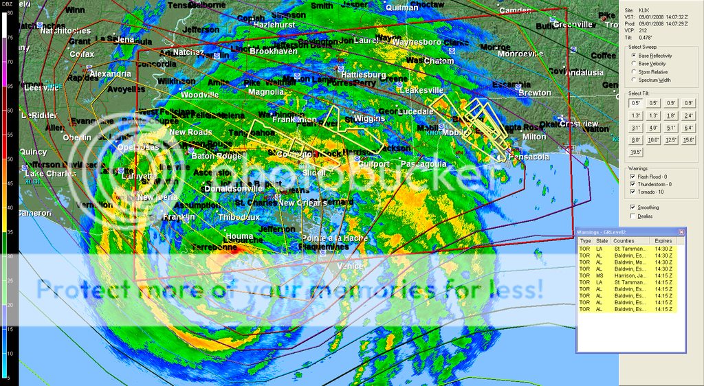
Ch 5 out of Mobile did say they there were NO confirmed touch downs, that it would be decided later for what ever that is worth. There are storm cells moving about 60 mph. They just said once more POSSIBLE tornados, no confirmed damage.


Ok, that makes it clear. You guys are reporting specifically for the Mobile/Pensacola area. I'm just reporting what I heard(literally heard) from WDSU out of New Orleans for tornadoes reported near Slidell and over to Bay St. Louis. Again, some were confirmed, not all. End of discussion on this ridiculousness for me.
0 likes   

User avatar
HURAKAN
Professional-Met
Professional-Met
Posts: 46086
Age: 38
Joined: Thu May 20, 2004 4:34 pm
Location: Key West, FL
Contact:

#9882 Postby HURAKAN » Mon Sep 01, 2008 9:09 am

657
WTNT52 KNHC 011359
TCEAT2
HURRICANE GUSTAV TROPICAL CYCLONE POSITION ESTIMATE
NWS TPC/NATIONAL HURRICANE CENTER MIAMI FL AL072008
900 AM CDT MON SEP 01 2008

AT 9 AM CDT...1200 UTC...THE CENTER OF HURRICANE GUSTAV WAS
ESTIMATED NEAR LATITUDE 29.0 NORTH...LONGITUDE 90.5 WEST OR ABOUT
75 MILES...135 KM...SOUTH OF NEW ORLEANS LOUISIANA AND
ABOUT 15 MILES...35 KM...SOUTH-SOUTHEAST OF COCODRIE LOUISIANA.

DURING THE LAST HOUR...THE NAVAL AIR STATION AT BELLE CHASSE
LOUISIANA REPORTED A WIND GUST OF 73 MPH...117 KM/HR.

$$
FORECASTER BEVEN
0 likes   

User avatar
stormy1970al
Tropical Storm
Tropical Storm
Posts: 158
Age: 55
Joined: Sat May 31, 2008 12:54 pm
Location: Fairhope AL

Re: Re:

#9883 Postby stormy1970al » Mon Sep 01, 2008 9:09 am

r_u_stuck2 wrote:
gboudx wrote:
r_u_stuck2 wrote:
Not according to our local TV weatherman. He just stated none have been spotted.


I'm not gonna fight with you over this, but I have heard very definitively on WDSU out of New Orleans of some confirmed tornado spottings by trained spotters. So unless the pro-met there is lying, then there have been some confirmed tornadoes. Can't vouch for you in Fla. Local is as Local does I guess.


Well, I am here in Pensacola listening to the local weatherman. He just stated again that all the tornado watches are coming from Mobile Weather center based on doppler. He just stated again, no tornadoes have been confirmed, but there has been a report of some hail.


I have to agree that none of them have been spotted except one last night that was in MS. The rest for our area has been on the radar. The siren on my tv from the NWS keep beeping every five minutes for my county. It has people on the edge when you hear there is a tornado warning for your area.
Last edited by stormy1970al on Mon Sep 01, 2008 9:10 am, edited 1 time in total.
0 likes   

User avatar
Stephanie
S2K Supporter
S2K Supporter
Posts: 23843
Age: 63
Joined: Thu Feb 06, 2003 9:53 am
Location: Glassboro, NJ

Re: Re:

#9884 Postby Stephanie » Mon Sep 01, 2008 9:09 am

jasons wrote:
funster wrote:Army Corps of Engineers sound very confident considering Gustav not even on shore yet - but it would be great if they are correct.


Yeah, so far, so good, but it's still too early to celebrate. The major surge push is just now coming into the NOLA area. The next few hours will be critical.


FORTUNATELY just about everyone is out this time.
0 likes   

jlauderdal
S2K Supporter
S2K Supporter
Posts: 7183
Joined: Wed May 19, 2004 5:46 am
Location: NE Fort Lauderdale
Contact:

Re: Cat 2 Hurricane Gustav making landfall

#9885 Postby jlauderdal » Mon Sep 01, 2008 9:11 am

10 tornado warnings

Image
0 likes   

User avatar
jenmrk
Tropical Storm
Tropical Storm
Posts: 106
Joined: Thu Sep 22, 2005 2:24 am
Location: Pensacola,Florida
Contact:

Re: Cat 2 Hurricane Gustav making landfall

#9886 Postby jenmrk » Mon Sep 01, 2008 9:12 am

I think it depends on which channel you listen to, I just changed to another local network and they have a differnat slant on it so who knows. I am just very happy that we are not watching a CAT 5 make landfall on NO once more and that most did the right thing and left.
My best to you all.
0 likes   

Evac3
Tropical Depression
Tropical Depression
Posts: 60
Joined: Sun Sep 23, 2007 1:59 pm
Location: Orange County, Southeast Texas

Re: Cat 2 Hurricane Gustav making landfall

#9887 Postby Evac3 » Mon Sep 01, 2008 9:12 am

Why haven't we had an NHC update/advisory for over three hours?
0 likes   

User avatar
WindRunner
Category 5
Category 5
Posts: 5806
Age: 34
Joined: Fri Jul 29, 2005 8:07 pm
Location: Warrenton, VA, but Albany, NY for school
Contact:

Re:

#9888 Postby WindRunner » Mon Sep 01, 2008 9:13 am

funster wrote:Army Corps of Engineers sound very confident considering Gustav not even on shore yet - but it would be great if they are correct.


I generally believe what they're saying, but I can hardly take the article seriously when they misspell a word like "forecast."
0 likes   

User avatar
WindRunner
Category 5
Category 5
Posts: 5806
Age: 34
Joined: Fri Jul 29, 2005 8:07 pm
Location: Warrenton, VA, but Albany, NY for school
Contact:

Re: Cat 2 Hurricane Gustav making landfall

#9889 Postby WindRunner » Mon Sep 01, 2008 9:13 am

Evac3 wrote:Why haven't we had an NHC update/advisory for over three hours?


We had a position update 13 minutes ago, and a secondary intermediate just 73 minutes ago...?
0 likes   

User avatar
Tom8
Tropical Storm
Tropical Storm
Posts: 195
Joined: Sun Aug 19, 2007 4:36 pm
Location: Poland,Slupsk
Contact:

Re: Cat 2 Hurricane Gustav making landfall

#9890 Postby Tom8 » Mon Sep 01, 2008 9:14 am

http://www.wunderground.com/wundermap/? ... r.show=cur

Tornado Storm Report:
2008-09-01 09:26:00 EDT
Lat/Lon: 30.42,-89.60
Location: Hancock County
Reported by ham radio operator n5wlw at stennis space center moving northwest. (Lix)

http://www.wunderground.com/US/AL/062.html

The National Weather Service in Mobile has issued a

* Tornado Warning for...
central Escambia County in northwest Florida...
east central Baldwin County in southwest Alabama...

* until 930 am CDT

* at 845 am CDT... National Weather Service Doppler radar indicated
another severe thunderstorm capable of producing a tornado 2 miles
south of Ensley... or about 7 miles northwest of Pensacola... moving
northwest at 54 mph.

* The tornado will be near...
rural central Escambia County at 900 am CDT
rural western Escambia County at 910 am CDT
rural central Baldwin County at 920 am CDT
0 likes   

User avatar
PTPatrick
Category 5
Category 5
Posts: 1831
Joined: Sat Jun 12, 2004 8:38 am

Re: Cat 2 Hurricane Gustav making landfall

#9891 Postby PTPatrick » Mon Sep 01, 2008 9:14 am

I cant get much news from the area because the websites are crap, but I can report that water is almost to the edgwater mall parking lot in Biloxi, gone well past HWY 90 in Hancock County, MS, and that the Beach blvd in pascagoula is covered. Wind in MS not bad though according to my sister...she is 2 blocks off ocean springs beach and just hanging out doing laundry. Water is also over some roads in the east jackson county communities south of 90(Bayou Cumbest and Orange Grove).
0 likes   

User avatar
KWT
Category 5
Category 5
Posts: 31415
Joined: Tue Aug 17, 2004 11:02 am
Location: UK!!!

#9892 Postby KWT » Mon Sep 01, 2008 9:15 am

10 tornado warnings, very impressive, you do tend to find the NE quadrant produce alot of tornadoes in these systems that were major hurricanes.

jenmrk, indeed however this is still a top end category-2 and its still a very bad situation for the gulf coast, still going to be some pretty severe damage and the hurricane still hasn't made landfall, really is trying its hardest to stay over water it seems!
0 likes   

Sanibel
Category 5
Category 5
Posts: 10375
Joined: Mon Aug 30, 2004 11:06 pm
Location: Offshore SW Florida

Re: Cat 2 Hurricane Gustav making landfall

#9893 Postby Sanibel » Mon Sep 01, 2008 9:15 am

Eye wrapped with moisture better than this morning.

This slow track clould be a touch more left. I suppose we'll see it move slowly over Terrebonne Bay and inland south of Lafayette. NHC must see the High pressure border, so I assume no shore-hugging west track will occur.
0 likes   

User avatar
WindRunner
Category 5
Category 5
Posts: 5806
Age: 34
Joined: Fri Jul 29, 2005 8:07 pm
Location: Warrenton, VA, but Albany, NY for school
Contact:

#9894 Postby WindRunner » Mon Sep 01, 2008 9:16 am

I'm curious senor, why are the SSTs so high in south central TX?
0 likes   

Evac3
Tropical Depression
Tropical Depression
Posts: 60
Joined: Sun Sep 23, 2007 1:59 pm
Location: Orange County, Southeast Texas

Re: Cat 2 Hurricane Gustav making landfall

#9895 Postby Evac3 » Mon Sep 01, 2008 9:16 am

WindRunner wrote:
Evac3 wrote:Why haven't we had an NHC update/advisory for over three hours?


We had a position update 13 minutes ago, and a secondary intermediate just 73 minutes ago...?


I mean the graphic with the cone. I'm a visual person. I don't have the attention span to read all the way through those big discussions. Just the forecast track and basic information would be nice.
0 likes   

User avatar
Chacor
Category 5
Category 5
Posts: 10229
Joined: Mon Oct 02, 2006 10:43 pm
Location: Singapore

Re: Cat 2 Hurricane Gustav making landfall

#9896 Postby Chacor » Mon Sep 01, 2008 9:18 am

Evac3 wrote:
WindRunner wrote:
Evac3 wrote:Why haven't we had an NHC update/advisory for over three hours?


We had a position update 13 minutes ago, and a secondary intermediate just 73 minutes ago...?


I mean the graphic with the cone. I'm a visual person. I don't have the attention span to read all the way through those big discussions. Just the forecast track and basic information would be nice.


Track forecasts do not change at intermediate advisories. They only change at full or special advisories. At intermediate advisories, the graphic will use the previous full forecast track with the updated position.

The next track forecast change will be at the full advisory package in 45 minutes.
0 likes   

User avatar
Stephanie
S2K Supporter
S2K Supporter
Posts: 23843
Age: 63
Joined: Thu Feb 06, 2003 9:53 am
Location: Glassboro, NJ

Re: Cat 2 Hurricane Gustav making landfall

#9897 Postby Stephanie » Mon Sep 01, 2008 9:18 am

PTPatrick wrote:I cant get much news from the area because the websites are crap, but I can report that water is almost to the edgwater mall parking lot in Biloxi, gone well past HWY 90 in Hancock County, MS, and that the Beach blvd in pascagoula is covered. Wind in MS not bad though according to my sister...she is 2 blocks off ocean springs beach and just hanging out doing laundry. Water is also over some roads in the east jackson county communities south of 90(Bayou Cumbest and Orange Grove).


Thank you for the report.
0 likes   

User avatar
HURAKAN
Professional-Met
Professional-Met
Posts: 46086
Age: 38
Joined: Thu May 20, 2004 4:34 pm
Location: Key West, FL
Contact:

#9898 Postby HURAKAN » Mon Sep 01, 2008 9:19 am

The storm surge at the Industrial Canal is at 10.50 feet and it will continue to increase. There is the real threat that it could overflow. Lets see what happens. This is according to the New Orleans TV station available on DirecTV channel 361.
0 likes   

jlauderdal
S2K Supporter
S2K Supporter
Posts: 7183
Joined: Wed May 19, 2004 5:46 am
Location: NE Fort Lauderdale
Contact:

Re: Cat 2 Hurricane Gustav making landfall

#9899 Postby jlauderdal » Mon Sep 01, 2008 9:20 am

Evac3 wrote:
WindRunner wrote:
Evac3 wrote:Why haven't we had an NHC update/advisory for over three hours?


We had a position update 13 minutes ago, and a secondary intermediate just 73 minutes ago...?


I mean the graphic with the cone. I'm a visual person. I don't have the attention span to read all the way through those big discussions. Just the forecast track and basic information would be nice.


you should watch the weather channel then, you might find that more enjoyable based on attention span, its very visual and ideal for those people that prefer to get very basic information..enjoy your hurricane tracking
0 likes   

Evac3
Tropical Depression
Tropical Depression
Posts: 60
Joined: Sun Sep 23, 2007 1:59 pm
Location: Orange County, Southeast Texas

Re: Cat 2 Hurricane Gustav making landfall

#9900 Postby Evac3 » Mon Sep 01, 2008 9:20 am

Evac3 wrote:Why haven't we had an NHC update/advisory for over three hours?


We had a position update 13 minutes ago, and a secondary intermediate just 73 minutes ago...?[/quote]

I mean the graphic with the cone. I'm a visual person. I don't have the attention span to read all the way through those big discussions. Just the forecast track and basic information would be nice.[/quote]

Track forecasts do not change at intermediate advisories. They only change at full or special advisories. At intermediate advisories, the graphic will use the previous full forecast track with the updated position.

The next track forecast change will be at the full advisory package in 45 minutes.[/quote]

Thanky. I guess I'll have to wait. I know they don't change the track but every six hours, but they have been updating the info in the little box every three. That 6am instead of 7am as usual is throwing me off.
0 likes   


Return to “2008”

Who is online

Users browsing this forum: No registered users and 4 guests