
IDW27400
TROPICAL CYCLONE TECHNICAL SUMMARY: AUSTRALIA - WESTERN REGION
Issued by PERTH TROPICAL CYCLONE WARNING CENTRE
at: 0707 UTC 16/02/2008
Name: Nicholas
Data At: 0600 UTC
[Latitude: 16.8S
Longitude: 118.1E
Location Accuracy: within 30 nm (55 km)
Movement Towards: south southwest (206 deg)
Speed of Movement:4 knots (8 km/h)
Maximum 10-Minute Wind: 65 knots (120 km/h)
Maximum 3-Second Wind Gust: 90 knots (170 km/h)
Central Pressure: 960 hPa
Radius of 34-knot winds NE quadrant: 90 nm (165 km)
Radius of 34-knot winds SE quadrant: 90 nm (165 km)
Radius of 34-knot winds SW quadrant: 90 nm (165 km)
Radius of 34-knot winds NW quadrant: 90 nm (165 km)
Radius of 48-knot winds NE quadrant: 40 nm (75 km)
Radius of 48-knot winds SE quadrant: 40 nm (75 km)
Radius of 48-knot winds SW quadrant: 40 nm (75 km)
Radius of 48-knot winds NW quadrant: 40 nm (75 km)
Radius of 64-knot winds: 20 nm (37 km)
Radius of Maximum Winds: 15 nm (28 km)
Dvorak Intensity Code: T4.0/4.5/D0.5/24HRS
Pressure of outermost isobar: 998 hPa
Radius of outermost closed isobar: 120 nm (220 km)
Storm Depth: Deep
FORECAST DATA
Date/Time : Location : Loc. Accuracy: Max Wind : Central Pressure
(UTC) : degrees : nm (km): knots(km/h): hPa
+12: 16/1800: 17.6S 117.6E: 060 (110): 070 (130): 956
+24: 17/0600: 18.4S 117.0E: 080 (150): 080 (150): 946
+36: 17/1800: 19.4S 116.3E: 100 (185): 090 (165): 932
+48: 18/0600: 20.6S 115.6E: 125 (230): 100 (185): 920
REMARKS:
Passive microwave and quikscat pass over the period from early morning indicate a south
southwest track has been established as previously forecast.
Quikscat pass this morning indicated 60 knot winds to the north and examination of the
ambiguities supports the choice of vector. This is considered a minimum maximum wind. On
the 0230Z VIS image a CDO analysis indicated a CF of 3.5 using a size of 1.75 degrees
irregular, with banding feature +1.0 a DT of 4.5 was obtained. Microwave around this time
also subjectively indicated that hurricane intensity had been reached. Since then some weakening
has been apparent and recent DT numbers using a curved band scene have arrived at wrap of
1.05-1.3 giving a DT of 4.0. Hence a FT of 4.0 is assigned with a CI of 4.5.
There is some disagreement in the models regarding shear conditions in the next 24 hours with
some models showing a further easing of upper winds while some maintain moderate easterly
shear. Further intensification is expected during the next 24 hours.but the rate of intensification
will be influenced by the degree of shear. Further southerly motion should favour an easing of
shear.
Notes:
This product is issued every six hours; the Cyclone Advices (Watches and Warnings) are
usually issued more frequently and contain more useful information for coastal communities.
Time Conversion from UTC to local:
WST add 8 hrs (Add another hour for daylight saving)
CST add 9 hrs 30 min
EST add 10 hrs (Add another hour for daylight saving)
==
The next bulletin for this system will be issued by: 16/1300 UTC by Perth TCWC.
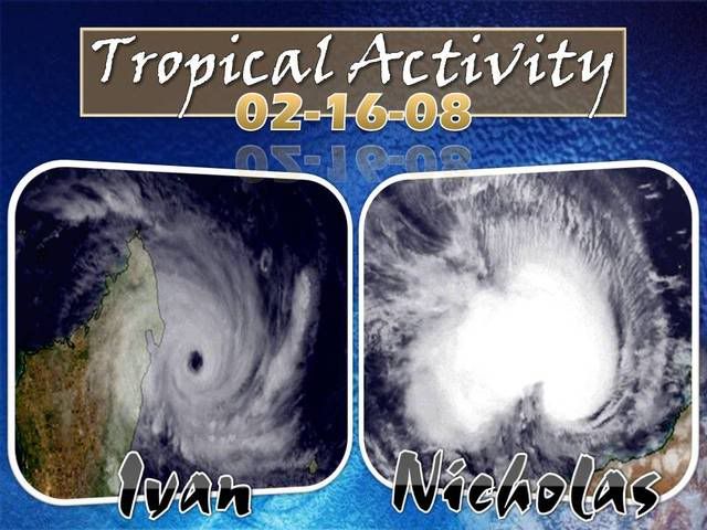
NW Australia: Tropical Cyclone Nicholas (19S)
Moderator: S2k Moderators


-
Pedro Fernández

- Tropical Storm

- Posts: 233
- Age: 46
- Joined: Mon Dec 31, 2007 7:24 am
- Location: Costa Tropical (Granada, Spain).
- Contact:
Re: W.Australia-Tropical Cyclone Nicholas (19S)
Latest discussion from Joint Typhoon Warning Center 9 UTC:
REMARKS:
160900Z POSITION NEAR 17.1S 117.9E.
TROPICAL CYCLONE (TC) 19S (NICHOLAS) LOCATED APPROXIMATELY 390 NM
NORTHEAST OF LEARMONTH, AUSTRALIA HAS TRACKED SOUTHWESTWARD AT
04 KNOTS OVER THE PAST 06 HOURS. TC 19S CONTINUES TO TRACK SOUTH-
WESTWARD ALONG THE NORTHWESTERN PERIPHERY OF A SUBTROPICAL STEERING
RIDGE OVER CENTRAL AUSTRALIA. THE STORM IS EXPECTED TO CONTINUE
SOUTHWESTWARD TO SOUTH-SOUTHWESTWARD AROUND THE PERIPHERY OF THE
CURRENT STEERING RIDGE THROUGH THE FORECAST PERIOD. THE SYSTEM HAS
MAINTAINED INTENSITY OVER THE PAST 06 HOURS UNDER THE COMPETING
INFLUENCES OF FAVORABLE UPPER LEVEL DIFFLUENCE AND HIGH OCEAN HEAT
CONTENT AND UNFAVORABLY HIGH EASTERLY VERTICAL WIND SHEAR. THE
SYSTEM IS EXPECTED TO SLOWLY INTENSIFY PRIOR TO LANDFALL AS THE
STORM MOVES CLOSER TO THE AXIS OF A SYNOPTIC SCALE UPPER LEVEL
ANTICYCLONE TO THE SOUTH AND WIND SHEAR CONSEQUENTLY DECREASES.
THE STORM WILL WEAKEN RAPIDLY AFTER LANDFALL BETWEEN TAU 48 AND
TAU 72. THE FORECAST TRACK REMAINS CLOSE TO THE PREVIOUS FORECAST
AND IS IN CLOSE AGREEMENT WITH THE MODEL CONSENSUS. MAXIMUM
SIGNIFICANT WAVE HEIGHT AT 160600Z IS 32 FEET. NEXT WARNINGS AT
161500Z, 162100Z, 170300Z, AND 170900Z. REFER TO TROPICAL CYCLONE
18S (IVAN) WARNINGS (WTXS33 PGTW) FOR SIX-HOURLY UPDATES.//
Intensity and location:
WTXS32 PGTW 160900
MSGID/GENADMIN/NAVPACMETOCCEN PEARL HARBOR HI//
SUBJ/TROPICAL CYCLONE WARNING//
RMKS/
1. TROPICAL CYCLONE 19S (NICHOLAS) WARNING NR 010
02 ACTIVE TROPICAL CYCLONES IN SOUTHIO
MAX SUSTAINED WINDS BASED ON ONE-MINUTE AVERAGE
---
WARNING POSITION:
160600Z --- NEAR 16.9S 118.0E
MOVEMENT PAST SIX HOURS - 215 DEGREES AT 04 KTS
POSITION ACCURATE TO WITHIN 060 NM
POSITION BASED ON CENTER LOCATED BY SATELLITE
PRESENT WIND DISTRIBUTION:
MAX SUSTAINED WINDS - 080 KT, GUSTS 100 KT
0 likes

-
Pedro Fernández
- Tropical Storm
- Posts: 233
- Age: 46
- Joined: Mon Dec 31, 2007 7:24 am
- Location: Costa Tropical (Granada, Spain).
- Contact:

-
Coredesat


-
HURAKAN

- Professional-Met

- Posts: 46086
- Age: 37
- Joined: Thu May 20, 2004 4:34 pm
- Location: Key West, FL
- Contact:
Re: W.Australia-Tropical Cyclone Nicholas (19S)
Australian Government Bureau of Meteorology
Western Australia
Media: The Standard Emergency Warning Signal should NOT be used with this
warning.
TOP PRIORITY FOR IMMEDIATE BROADCAST
TROPICAL CYCLONE ADVICE NUMBER 40
Issued at 10:00 pm WDT on Saturday, 16 February 2008
BY THE BUREAU OF METEOROLOGY
TROPICAL CYCLONE WARNING CENTRE PERTH
A Cyclone WARNING is now current for coastal areas from Pardoo to Exmouth.
A Cyclone WATCH is current for coastal areas from Exmouth to Coral Bay and
adjacent inland areas
At 9:00 pm WDT Severe Tropical Cyclone Nicholas was estimated to be
330 kilometres north of Karratha and
310 kilometres north northwest of Port Hedland and
moving south southwest at 16 kilometres per hour.
Severe Tropical Cyclone Nicholas has accelerated towards the southwest in the
past 6-12 hours, and is expected to continue to track towards the coast on
Sunday. There is a significant risk of an impact from a Severe Tropical Cyclone
on the Pilbara coast as early as Sunday evening, but more likely on Monday.
Gales could affect coastal and island communities between Pardoo and Exmouth on
Sunday. Gales may extend south to Coral Bay and adjacent inland areas during
Monday
and Tuesday.
Details of Severe Tropical Cyclone Nicholas at 9:00 pm WDT:
Centre located near...... 17.8 degrees South 117.4 degrees East
Location accuracy........ within 46 kilometres
Recent movement.......... towards the south southwest at 16 kilometres per hour
Wind gusts near centre... 185 kilometres per hour
Severity category........ 3
Central pressure......... 956 hectoPascals
FESA-State Emergency Service advises of the following community alerts:
BLUE ALERT: People in or near coastal Pilbara communities between Pardoo and
Mardie, including Port Hedland, Wickham, Point Samson, Roebourne, Karratha,
Dampier and Mardie.
People in coastal and adjacent inland Pilbara communities should listen for the
next advice.
The next advice will be issued by 1:00 am WDT Sunday 17 February.
Cyclone advices and State Emergency Service Community Alerts are available by
dialling 1300 659 210
0 likes
-
Ed Mahmoud
Re: W.Australia-Tropical Cyclone Nicholas (19S)
That NOGAPS path actually suggests some weather for Perth/Freemantle.
I have been intoxicated in Perth and Freemantle.
I have been intoxicated in Perth and Freemantle.
0 likes
Re: W.Australia-Tropical Cyclone Nicholas (19S)
Is that Ivan the Terrible and Nicholas the Great ?
0 likes
-
HurricaneRobert
- Category 3

- Posts: 812
- Joined: Fri May 18, 2007 9:31 pm
-
HURAKAN
- Professional-Met
- Posts: 46086
- Age: 37
- Joined: Thu May 20, 2004 4:34 pm
- Location: Key West, FL
- Contact:
Australian Government Bureau of Meteorology
Western Australia
Media: The Standard Emergency Warning Signal should NOT be used with this
warning.
TOP PRIORITY FOR IMMEDIATE BROADCAST
TROPICAL CYCLONE ADVICE NUMBER 41
Issued at 1:00 am WDT on Sunday, 17 February 2008
BY THE BUREAU OF METEOROLOGY
TROPICAL CYCLONE WARNING CENTRE PERTH
A Cyclone WARNING is current for coastal areas from Pardoo to Exmouth.
A Cyclone WATCH is current for coastal areas from Exmouth to Coral Bay and
adjacent inland areas
At 12:00 am WDT Severe Tropical Cyclone Nicholas was estimated to be
350 kilometres north of Karratha and
560 kilometres north northeast of Exmouth and
moving west at 15 kilometres per hour.
Severe Tropical Cyclone Nicholas is currently moving towards the west, but is
expected to begin to track southwest towards the coast today. There is the risk
of an impact from a Severe Tropical Cyclone on the west Pilbara coast on Monday.
Gales could affect coastal and island communities between Pardoo and Exmouth
later today. Gales may extend south to Coral Bay and adjacent inland areas
during Monday and Tuesday.
Details of Severe Tropical Cyclone Nicholas at 12:00 am WDT:
Centre located near...... 17.6 degrees South 116.9 degrees East
Location accuracy........ within 37 kilometres
Recent movement.......... towards the west at 15 kilometres per hour
Wind gusts near centre... 195 kilometres per hour
Severity category........ 3
Central pressure......... 952 hectoPascals
FESA-State Emergency Service advises of the following community alerts:
BLUE ALERT: People in or near coastal Pilbara communities between Pardoo and
Mardie, including Port Hedland, Wickham, Point Samson, Roebourne, Karratha,
Dampier and Mardie.
People in coastal and adjacent inland Pilbara communities should listen for the
next advice.
The next advice will be issued by 4:00 am WDT Sunday 17 February.
Cyclone advices and State Emergency Service Community Alerts are available by
dialling 1300 659 210
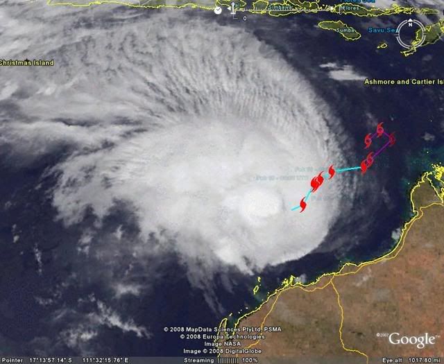
A map showing the track of the cyclone is available at:
http://www.bom.gov.au/weather/cyclone
Western Australia
Media: The Standard Emergency Warning Signal should NOT be used with this
warning.
TOP PRIORITY FOR IMMEDIATE BROADCAST
TROPICAL CYCLONE ADVICE NUMBER 41
Issued at 1:00 am WDT on Sunday, 17 February 2008
BY THE BUREAU OF METEOROLOGY
TROPICAL CYCLONE WARNING CENTRE PERTH
A Cyclone WARNING is current for coastal areas from Pardoo to Exmouth.
A Cyclone WATCH is current for coastal areas from Exmouth to Coral Bay and
adjacent inland areas
At 12:00 am WDT Severe Tropical Cyclone Nicholas was estimated to be
350 kilometres north of Karratha and
560 kilometres north northeast of Exmouth and
moving west at 15 kilometres per hour.
Severe Tropical Cyclone Nicholas is currently moving towards the west, but is
expected to begin to track southwest towards the coast today. There is the risk
of an impact from a Severe Tropical Cyclone on the west Pilbara coast on Monday.
Gales could affect coastal and island communities between Pardoo and Exmouth
later today. Gales may extend south to Coral Bay and adjacent inland areas
during Monday and Tuesday.
Details of Severe Tropical Cyclone Nicholas at 12:00 am WDT:
Centre located near...... 17.6 degrees South 116.9 degrees East
Location accuracy........ within 37 kilometres
Recent movement.......... towards the west at 15 kilometres per hour
Wind gusts near centre... 195 kilometres per hour
Severity category........ 3
Central pressure......... 952 hectoPascals
FESA-State Emergency Service advises of the following community alerts:
BLUE ALERT: People in or near coastal Pilbara communities between Pardoo and
Mardie, including Port Hedland, Wickham, Point Samson, Roebourne, Karratha,
Dampier and Mardie.
People in coastal and adjacent inland Pilbara communities should listen for the
next advice.
The next advice will be issued by 4:00 am WDT Sunday 17 February.
Cyclone advices and State Emergency Service Community Alerts are available by
dialling 1300 659 210
A map showing the track of the cyclone is available at:
http://www.bom.gov.au/weather/cyclone
0 likes
-
HURAKAN
- Professional-Met
- Posts: 46086
- Age: 37
- Joined: Thu May 20, 2004 4:34 pm
- Location: Key West, FL
- Contact:
Re: W.Australia-Tropical Cyclone Nicholas (19S)
Australian Government Bureau of Meteorology
Western Australia
Media: The Standard Emergency Warning Signal should NOT be used with this
warning.
TOP PRIORITY FOR IMMEDIATE BROADCAST
TROPICAL CYCLONE ADVICE NUMBER 42
Issued at 3:45 am WDT on Sunday, 17 February 2008
BY THE BUREAU OF METEOROLOGY
TROPICAL CYCLONE WARNING CENTRE PERTH
A Cyclone WARNING is current for coastal areas from Whim Creek to Exmouth.
A Cyclone WATCH is current for coastal areas from Exmouth to Cape Cuvier and
adjacent inland areas
The Cyclone Warning for coastal areas from Pardoo to Whim Creek has been
cancelled.
At 3:00 am WDT Severe Tropical Cyclone Nicholas was estimated to be
350 kilometres north of Karratha and
560 kilometres north northeast of Exmouth and
moving west at 6 kilometres per hour.
Severe Tropical Cyclone Nicholas has slowed in the last 3 hours and is currently
moving towards the west, but is expected to begin to track southwest towards the
coast during today. There is the risk of an impact from a Severe Tropical
Cyclone on the west Pilbara coast late Monday or early Tuesday.
Gales could affect coastal and island communities between Whim Creek and Exmouth
later today. Gales may extend south to Cape Cuvier and adjacent inland areas
during Monday and Tuesday.
Details of Severe Tropical Cyclone Nicholas at 3:00 am WDT:
Centre located near...... 17.6 degrees South 116.9 degrees East
Location accuracy........ within 37 kilometres
Recent movement.......... towards the west at 6 kilometres per hour
Wind gusts near centre... 215 kilometres per hour
Severity category........ 3
Central pressure......... 944 hectoPascals
FESA-State Emergency Service advises of the following community alerts:
BLUE ALERT: People in or near coastal Pilbara communities between Whim Creek and
Mardie, including Wickham, Point Samson, Roebourne, Karratha, Dampier and
Mardie.
ALL CLEAR WITH CAUTION: People in communities from Pardoo to Whim Creek,
including Port Hedland are advised to proceed with caution.
People in coastal and adjacent inland Pilbara communities should listen for the
next advice.
The next advice will be issued by 7:00 am WDT Sunday 17 February.
Cyclone advices and State Emergency Service Community Alerts are available by
dialling 1300 659 210
Almost a Cat. 4:
4 Severe Tropical Cyclone 225 - 279 km/h
Very destructive winds
0 likes
-
Squarethecircle
- Category 5

- Posts: 2165
- Joined: Fri Oct 19, 2007 4:00 pm
- Location: Fairfax, VA
-
Pedro Fernández
- Tropical Storm
- Posts: 233
- Age: 46
- Joined: Mon Dec 31, 2007 7:24 am
- Location: Costa Tropical (Granada, Spain).
- Contact:
NRL/Navy sais 967 mb and 75 KT........... I have just looked at the time of the image but it's OK... I guess there is an error 
DVORAK technique hasn't changed a lot since the last records today:
16/1430 UTC 17.8S 116.9E T4.5/4.5 NICHOLAS -- South Indian Ocean
16/0830 UTC 17.6S 117.7E T4.5/4.5 NICHOLAS -- South Indian Ocean
16/0230 UTC 16.5S 118.1E T4.5/4.5 NICHOLAS -- South Indian Ocean
DVORAK technique hasn't changed a lot since the last records today:
16/1430 UTC 17.8S 116.9E T4.5/4.5 NICHOLAS -- South Indian Ocean
16/0830 UTC 17.6S 117.7E T4.5/4.5 NICHOLAS -- South Indian Ocean
16/0230 UTC 16.5S 118.1E T4.5/4.5 NICHOLAS -- South Indian Ocean
0 likes
-
HURAKAN
- Professional-Met
- Posts: 46086
- Age: 37
- Joined: Thu May 20, 2004 4:34 pm
- Location: Key West, FL
- Contact:
Australian Government Bureau of Meteorology
Western Australia
Media: The Standard Emergency Warning Signal should NOT be used with this
warning.
TOP PRIORITY FOR IMMEDIATE BROADCAST
TROPICAL CYCLONE ADVICE NUMBER 43
Issued at 6:35 am WDT on Sunday, 17 February 2008
BY THE BUREAU OF METEOROLOGY
TROPICAL CYCLONE WARNING CENTRE PERTH
A Cyclone WARNING is current for coastal areas from Whim Creek to Exmouth.
A Cyclone WATCH is current for coastal areas from Exmouth to Cape Cuvier and
adjacent inland areas
At 6:00 am WDT Severe Tropical Cyclone Nicholas was estimated to be
325 kilometres north of Karratha and
535 kilometres north northeast of Exmouth and
moving southwest at 5 kilometres per hour.
Severe Tropical Cyclone Nicholas has resumed a South westwards track in the last
3 hours and is currently moving towards the west Pilbara coast. There is the
risk of an impact from a Severe Tropical Cyclone on the west Pilbara coast late
Monday or early Tuesday.
Gales could affect coastal and island communities between Whim Creek and Exmouth
later today or on Monday. Gales may extend south to Cape Cuvier and adjacent
inland areas later Monday and Tuesday.
Details of Severe Tropical Cyclone Nicholas at 6:00 am WDT:
Centre located near...... 17.8 degrees South 116.7 degrees East
Location accuracy........ within 37 kilometres
Recent movement.......... towards the southwest at 5 kilometres per hour
Wind gusts near centre... 215 kilometres per hour
Severity category........ 3
Central pressure......... 944 hectoPascals
FESA-State Emergency Service advises of the following community alerts:
YELLOW ALERT: People in or near coastal Pilbara communities between Whim Creek
and Dampier, including Wickham, Point Samson, Roebourne, Karratha and Dampier.
BLUE ALERT: People in or near coastal Pilbara communities between Dampier and
Exmouth, including Mardie, Onslow and Exmouth.
People in coastal and adjacent inland Pilbara communities should listen for the
next advice.
The next advice will be issued by 10:00 am WDT Sunday 17 February.
Cyclone advices and State Emergency Service Community Alerts are available by
dialling 1300 659 210
A map showing the track of the cyclone is available at:
http://www.bom.gov.au/weather/cyclone
0 likes

Who is online
Users browsing this forum: No registered users and 10 guests