8.9N 95.2E
According to ECWMF, it will develop into a Tropical Cyclone with maximum sustained wind more than 50 m/s days later. However, we cannot rule out the possibility that it will be designated as 96B after some better organization.
Myanmar / TC NARGIS (TC 01B) Update: 84,500 dead
Moderator: S2k Moderators
-
wyq614

- Category 3

- Posts: 827
- Age: 35
- Joined: Sun Dec 02, 2007 12:32 am
- Location: Beijing, China (Hometown: Qingdao, China, 36.06N 120.43E)
- Contact:
Myanmar / TC NARGIS (TC 01B) Update: 84,500 dead
Last edited by cycloneye on Tue Jun 24, 2008 2:57 pm, edited 15 times in total.
Reason: Updated 'reported' death toll.
Reason: Updated 'reported' death toll.
0 likes
-
wyq614
- Category 3
- Posts: 827
- Age: 35
- Joined: Sun Dec 02, 2007 12:32 am
- Location: Beijing, China (Hometown: Qingdao, China, 36.06N 120.43E)
- Contact:
Re: North Indian Ocean - Invest (扰动) 95B
wyq614 wrote:8.9N 95.2E
According to ECWMF, it will develop into a Tropical Cyclone with maximum sustained wind more than 50 m/s days later. However, we cannot rule out the possibility that it will be designated as 96B after some better organization.
0 likes


-
Derek Ortt
NIO Invest 95B
http://www.nrlmry.navy.mil/tc-bin/tc_ho ... D=1km_zoom
Looking quite good to say the least. Looks to have a nice LLC already and conditions not entirely unfavorable
Looking quite good to say the least. Looks to have a nice LLC already and conditions not entirely unfavorable
0 likes


-
HurricaneRobert
- Category 3
- Posts: 812
- Joined: Fri May 18, 2007 9:31 pm

FQIN01 DEMS 260900
SHIPPING BULLETIN FOR MET. AREA VIII (N),NORTH OF EQUATOR
VALID FOR 24 HOURS.FROM 26/04/2008 0900 UTC 26 APRIL 2008
================================================================
PART -I :NO STORM WARNING(.)
PART II:- A LOW PRESSURE AREA HAS FOUND OVER SE-BAY AND
N/HOOD (.)
WEATHER SEASONAL OVER REST MET AREA (.)
PART III : FORECAST(.)
A1 ARABIAN SEA EQUATOR TO 10 DEG.N AND W OF 80 DEG.E(.)
I)WIND:W/SW 10/15 KTS (.)
II)WEATHER:SCATTERED RA/TS TO THE E OF 70 DEG E. (.)
REST AREA ISOLATED RA/TS (.)
III)VISIBILITY:POOR IN RA/TS(.)
IV) STATE OF SEA :SMOOTH TO SLIGHT(.)
ARB :A2 ARABIAN SEA N. OF 10 DEG N.AND W OF 80 DEG E.(.)
I)WIND: NW/W 10/15 KTS (.)
II)WEATHER:FAIR (.)
III) VISIBILITY :GOOD (.)
IV) STATE OF SEA : SMOOTH TO SLIGHT(.)
BOB : A3 BAY OF BENGAL EQUATOR TO 08 DEG.N AND E OF 80 DEG.E(.)
I)WIND:-MAINLY SW-LY 15/20 KTS (.)
II)WEATEHR:- SCATTERED RA/TS (.)
III)VISIBILITY:POOR IN RA/TS (.)
IV)STATE OF SEA: SLIGHT TO MODERATE (.)
BOB A4 : BAY OF BENGAL N OF 08 DEG.N AND E OF 80 DEG E(.)
I) WIND : SOUTH OF 15 DEG N:-CYCLONIC 10/15 KTS (.)
NORTH OF 15 DEG N:-S/SW 10/15 KTS (.)
II)WEATHER:-FAIRLY WIDESPREAD RA/TS TO THE S OF 15 DEG.N (.)
REST AREA ISOLATED RA/TS (.)
III) VISIBILTY:POOR IN RA/TS (.)
IV) STATE OF SEA :SMOOTH TO SLIGHT (.)
ISSUED BY INDIA METEOROLOGICAL DEPARTMENT
0 likes
-
HURAKAN

- Professional-Met

- Posts: 46086
- Age: 37
- Joined: Thu May 20, 2004 4:34 pm
- Location: Key West, FL
- Contact:
Re: North Indian Ocean - Invest (扰动) 95B


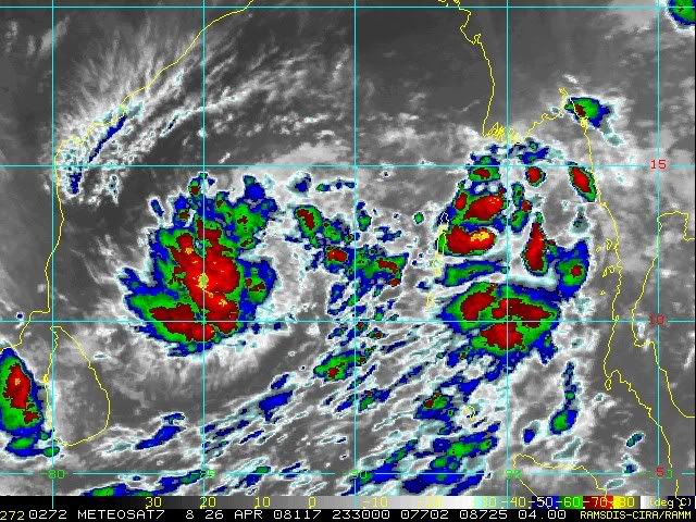
26/2030 UTC 11.2N 86.4E T1.5/1.5 95B -- Bay of Bengal
0 likes
-
HURAKAN
- Professional-Met
- Posts: 46086
- Age: 37
- Joined: Thu May 20, 2004 4:34 pm
- Location: Key West, FL
- Contact:
THE AREA OF CONVECTION PREVIOUSLY LOCATED NEAR 10.4N 90.4E
IS NOW LOCATED NEAR 11.4N 87.8E, APPROXIMATELY 460 NM EAST-SOUTHEAST
OF MADRAS, INDIA. RECENT ANIMATED INFRARED IMAGERY AND A 261344Z
SSMIS IMAGE SHOW DEEP CONVECTION SCATTERED AROUND A CONSOLIDATING LOW
LEVEL CIRCULATION CENTER (LLCC). A 261202Z QUIKSCAT IMAGE DISPLAYS A
BAND OF 20-25 KT WINDS AT A RADIUS OF APPROXIMATELY 70 NM FROM THE
LLCC. UPPER LEVEL ANALYSIS INDICATES A FAVORABLE ENVIRONMENT FOR
DEVELOPMENT, WITH GOOD POLEWARD OUTFLOW AND LOW VERTICAL WIND SHEAR.
MAXIMUM SUSTAINED SURFACE WINDS ARE ESTIMATED AT 20 TO 25 KNOTS.
MINIMUM SEA LEVEL PRESSURE IS ESTIMATED TO BE NEAR 1005 MB. THE
POTENTIAL FOR THE DEVELOPMENT OF A SIGNIFICANT TROPICAL CYCLONE
WITHIN THE NEXT 24 HOURS IS UPGRADED TO FAIR.
0 likes

-
Derek Ortt


-
Derek Ortt


Who is online
Users browsing this forum: No registered users and 110 guests