ATL: Tropical Depression Dolly

Moderator: S2k Moderators

Message
Author
User avatar
zaqxsw75050
Tropical Storm
Tropical Storm
Posts: 178
Joined: Thu Mar 06, 2008 4:21 pm
Location: Hong Kong

ATL: Tropical Depression Dolly

#1 Postby zaqxsw75050 » Sun Jul 13, 2008 1:49 am

8.9N 36.4W, 20kts

Image

Image
Last edited by zaqxsw75050 on Mon Jul 14, 2008 12:45 am, edited 2 times in total.
0 likes   

User avatar
Cyclenall
Category 5
Category 5
Posts: 6627
Joined: Thu Jun 08, 2006 10:01 pm
Location: Ontario, Canada

#2 Postby Cyclenall » Sun Jul 13, 2008 1:52 am

I had a feeling this would come up as a Invest first and foremost. I don't know much about this one.
0 likes   

User avatar
HURAKAN
Professional-Met
Professional-Met
Posts: 46086
Age: 37
Joined: Thu May 20, 2004 4:34 pm
Location: Key West, FL
Contact:

#3 Postby HURAKAN » Sun Jul 13, 2008 1:53 am

570
WHXX01 KWBC 130645
CHGHUR
TROPICAL CYCLONE GUIDANCE MESSAGE
NWS TPC/NATIONAL HURRICANE CENTER MIAMI FL
0645 UTC SUN JUL 13 2008

DISCLAIMER...NUMERICAL MODELS ARE SUBJECT TO LARGE ERRORS.
PLEASE REFER TO NHC OFFICIAL FORECASTS FOR TROPICAL CYCLONE
AND SUBTROPICAL CYCLONE INFORMATION.

ATLANTIC OBJECTIVE AIDS FOR

DISTURBANCE INVEST (AL942008) 20080713 0600 UTC

...00 HRS... ...12 HRS... ...24 HRS. .. ...36 HRS...
080713 0600 080713 1800 080714 0600 080714 1800

LAT LON LAT LON LAT LON LAT LON
BAMS 8.8N 36.4W 9.4N 37.8W 9.8N 38.8W 10.2N 40.3W
BAMD 8.8N 36.4W 9.3N 38.0W 9.9N 39.4W 10.6N 40.8W
BAMM 8.8N 36.4W 9.3N 37.9W 9.9N 39.2W 10.6N 40.7W
LBAR 8.8N 36.4W 9.1N 38.0W 9.6N 39.6W 10.2N 41.8W
SHIP 20KTS 23KTS 28KTS 35KTS
DSHP 20KTS 23KTS 28KTS 35KTS

...48 HRS... ...72 HRS... ...96 HRS. .. ..120 HRS...
080715 0600 080716 0600 080717 0600 080718 0600

LAT LON LAT LON LAT LON LAT LON
BAMS 10.6N 42.7W 11.4N 49.2W 11.8N 56.3W 11.8N 63.4W
BAMD 11.1N 42.6W 12.2N 47.3W 12.9N 52.2W 13.5N 56.8W
BAMM 10.8N 42.7W 11.4N 48.2W 11.4N 53.9W 10.9N 59.3W
LBAR 10.7N 43.9W 12.2N 49.3W 13.2N 55.2W 14.3N 60.7W
SHIP 41KTS 53KTS 61KTS 66KTS
DSHP 41KTS 53KTS 61KTS 66KTS

...INITIAL CONDITIONS...
LATCUR = 8.8N LONCUR = 36.4W DIRCUR = 280DEG SPDCUR = 5KT
LATM12 = 8.6N LONM12 = 35.6W DIRM12 = 282DEG SPDM12 = 5KT
LATM24 = 8.5N LONM24 = 34.2W
WNDCUR = 20KT RMAXWD = 60NM WNDM12 = 20KT
CENPRS = 1012MB OUTPRS = 1015MB OUTRAD = 150NM SDEPTH = D
RD34NE = 0NM RD34SE = 0NM RD34SW = 0NM RD34NW = 0NM

$$
NNN
0 likes   

User avatar
HURAKAN
Professional-Met
Professional-Met
Posts: 46086
Age: 37
Joined: Thu May 20, 2004 4:34 pm
Location: Key West, FL
Contact:

#4 Postby HURAKAN » Sun Jul 13, 2008 1:54 am

Image
0 likes   

User avatar
HURAKAN
Professional-Met
Professional-Met
Posts: 46086
Age: 37
Joined: Thu May 20, 2004 4:34 pm
Location: Key West, FL
Contact:

#5 Postby HURAKAN » Sun Jul 13, 2008 1:55 am

Image
0 likes   

User avatar
Matt-hurricanewatcher
Category 5
Category 5
Posts: 11649
Age: 38
Joined: Fri Nov 26, 2004 11:09 pm
Location: Portland,OR
Contact:

Re: Invest 94L

#6 Postby Matt-hurricanewatcher » Sun Jul 13, 2008 2:28 am

I think this has by far a better chance of developing.

1# Lots of convection
2# Low shear

The ship model forecast strengthing to a point where you can be some what safe to assume it may have a chance of developing. It will likley be a low rider.

People you know those ship of the LINE ships of old. Remember how when the doors opened up on the sides and the cannons started to come out. I clearly see those cannons coming out right now. Maybe not as intense of 2004, but 1998,99 or 96 is looking possible.

Maybe it would be a good idea to buy homes that can be moved from the coast to inland?
0 likes   

Ad Novoxium
Category 1
Category 1
Posts: 348
Age: 33
Joined: Sat May 03, 2008 2:12 am

#7 Postby Ad Novoxium » Sun Jul 13, 2008 2:56 am

Just looking at that image, this has a shape that looks a little heart-ish. After Nargis, that's a pretty horrid thing to point out.

And from the models, it appears BAMM does a Tropical Storm Alma (1974) into Trinidad and Venezuela. The other models are...disheartening, to say the least.
0 likes   

User avatar
KWT
Category 5
Category 5
Posts: 31390
Joined: Tue Aug 17, 2004 11:02 am
Location: UK!!!

#8 Postby KWT » Sun Jul 13, 2008 3:22 am

Looking very interesting, this one if it forms is almost certainly going to be a threat to the Caribbean and could end up threatening the USA depending on exact track.

Anyway there is still loads of deep convection with the area though the actual region most primed for development is on the eastern side of the deeep convection.

Need to be watched for development, no certainties but its in a good enough location right now for development to slowly occur.
0 likes   

User avatar
cycloneye
Admin
Admin
Posts: 139089
Age: 67
Joined: Thu Oct 10, 2002 10:54 am
Location: San Juan, Puerto Rico

ATL: INVEST 94L

#9 Postby cycloneye » Sun Jul 13, 2008 5:41 am

This will take sometime to organize as its a big system.But only its location presents future problems for the Lesser Antilles and other landmasses upstream.

Lets see how many pages this thread will have:

Image
0 likes   

User avatar
stormchazer
Category 5
Category 5
Posts: 2458
Joined: Fri Aug 29, 2003 12:00 pm
Location: Lakeland, Florida
Contact:

#10 Postby stormchazer » Sun Jul 13, 2008 5:51 am

The interaction with Bertha could be interesting here. Will the weakness that is suppose to grab Bertha allow this feature to escape as well, or at minimum, pull it far enough north to be affected by future weaknesses? I am not sure the models showing it going straight into the Carribean are a lock.

Heck this assumes it even develops.
0 likes   

User avatar
Matt-hurricanewatcher
Category 5
Category 5
Posts: 11649
Age: 38
Joined: Fri Nov 26, 2004 11:09 pm
Location: Portland,OR
Contact:

Re: ATL: INVEST 94L East of Windward Islands

#11 Postby Matt-hurricanewatcher » Sun Jul 13, 2008 6:23 am

This looks more impressive in some ways then Bertha.
0 likes   

Kennethb
Category 2
Category 2
Posts: 504
Joined: Thu Aug 14, 2003 7:15 am
Location: Baton Rouge

#12 Postby Kennethb » Sun Jul 13, 2008 6:30 am

Should 94L be able to gain latitude and enter the Carribean, it still will have to makes its way through the zone of death for tropical systems, especially so early in the season.
0 likes   

User avatar
Matt-hurricanewatcher
Category 5
Category 5
Posts: 11649
Age: 38
Joined: Fri Nov 26, 2004 11:09 pm
Location: Portland,OR
Contact:

Re:

#13 Postby Matt-hurricanewatcher » Sun Jul 13, 2008 6:32 am

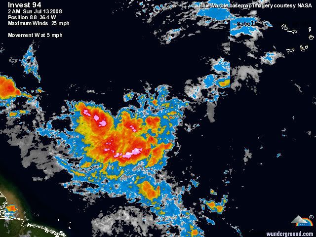
Kennethb wrote:Should 94L be able to gain latitude and enter the Carribean, it still will have to makes its way through the zone of death for tropical systems, especially so early in the season.


Remember Charley, Emily, made it. This seems to have good outflow trying to develop and nice shape. If convection can keep firing over the developing "LLC" I would expect a cyclone out of this within 36 hours.
0 likes   

Derek Ortt

#14 Postby Derek Ortt » Sun Jul 13, 2008 6:40 am

what zone of death?
0 likes   

User avatar
Emmett_Brown
Category 5
Category 5
Posts: 1343
Joined: Wed Aug 24, 2005 9:10 pm
Location: Sarasota FL

Re: ATL: INVEST 94L East of Windward Islands

#15 Postby Emmett_Brown » Sun Jul 13, 2008 6:43 am

Derek Ortt wrote:what zone of death?


True... seems like in recent years (whitness Dean and Felix) that this area is quite favorable for development; quite the oposite of a zone of death. I think we can safely call this theory defunked.
0 likes   

User avatar
ronjon
Category 5
Category 5
Posts: 4671
Joined: Fri Aug 19, 2005 5:17 pm
Location: Hernando Beach, FL

Re: ATL: INVEST 94L East of Windward Islands

#16 Postby ronjon » Sun Jul 13, 2008 6:47 am

The GFS appears to be an outlier as of now as it swings this future system NE of the leewards. All of the other global models either keep it weaker and slower (and more south) or bring it into the central leewards in about 5 days (Euro, CMC,BAMD). I would expect slower development than the GFS and thus the system should eventually be a caribbean threat. Is this low pressure destined to become the next Dennis (2005) or Ivan (2004)? Ivan formed near 9N-29W.
0 likes   

User avatar
cycloneye
Admin
Admin
Posts: 139089
Age: 67
Joined: Thu Oct 10, 2002 10:54 am
Location: San Juan, Puerto Rico

Re: ATL: INVEST 94L East of Windward Islands

#17 Postby cycloneye » Sun Jul 13, 2008 6:49 am

943
ABNT20 KNHC 131145
TWOAT
TROPICAL WEATHER OUTLOOK
NWS TPC/NATIONAL HURRICANE CENTER MIAMI FL
800 AM EDT SUN JUL 13 2008

FOR THE NORTH ATLANTIC...CARIBBEAN SEA AND THE GULF OF MEXICO...

THE NATIONAL HURRICANE CENTER IS ISSUING ADVISORIES ON
RECENTLY-DOWNGRADED TROPICAL STORM BERTHA...LOCATED ABOUT 220 MILES
SOUTHEAST OF BERMUDA.

AN AREA OF DISTURBED WEATHER HAS FORMED OVER THE TROPICAL ATLANTIC
ABOUT 1600 MILES EAST OF THE SOUTHERN WINDWARD ISLANDS. CONDITIONS
APPEAR FAVORABLE FOR ADDITIONAL DEVELOPMENT OF THIS SYSTEM DURING
THE NEXT COUPLE OF DAYS.


SHOWER ACTIVITY HAS INCREASED THIS MORNING IN ASSOCIATION WITH A
WEAK FRONTAL LOW PRESSURE AREA CENTERED ABOUT 130 MILES SOUTHEAST
OF CHARLESTON SOUTH CAROLINA. SLOW DEVELOPMENT OF THIS SYSTEM IS
POSSIBLE DURING THE NEXT DAY OR TWO AS MOVES SLOWLY TO THE
NORTHEAST.

ELSEWHERE...TROPICAL CYCLONE FORMATION IS NOT EXPECTED DURING THE
NEXT 48 HOURS.

$$
FORECASTER BEVEN
0 likes   

bob rulz
Category 5
Category 5
Posts: 1667
Age: 34
Joined: Sat Jan 28, 2006 7:30 pm
Location: Salt Lake City, Utah

#18 Postby bob rulz » Sun Jul 13, 2008 6:51 am

Beat me to it by like 5 seconds. :roll:

And poof there's suddenly two new areas of interest to talk about in the outlook. Very interesting.
0 likes   

User avatar
Chacor
Category 5
Category 5
Posts: 10229
Joined: Mon Oct 02, 2006 10:43 pm
Location: Singapore

#19 Postby Chacor » Sun Jul 13, 2008 7:20 am

It's orange on the GTWO.
0 likes   

User avatar
cycloneye
Admin
Admin
Posts: 139089
Age: 67
Joined: Thu Oct 10, 2002 10:54 am
Location: San Juan, Puerto Rico

Re: ATL: INVEST 94L East of Windward Islands

#20 Postby cycloneye » Sun Jul 13, 2008 7:24 am

Image
0 likes   


Return to “2008”

Who is online

Users browsing this forum: No registered users and 101 guests