ATL: Tropical Depression Dolly

Moderator: S2k Moderators

Message
Author
User avatar
Matt-hurricanewatcher
Category 5
Category 5
Posts: 11649
Age: 38
Joined: Fri Nov 26, 2004 11:09 pm
Location: Portland,OR
Contact:

Re: ATL: Tropical Depression Dolly

#8401 Postby Matt-hurricanewatcher » Fri Jul 25, 2008 10:00 pm

Ed Mahmoud wrote:JB's rant today said official wind for Dolly, at 964 mb, was the lowest wind for that pressure ever in Gulf of Mexico, and no matter what anyone says, he is convinced that it made landfall between 100 and 105 mph, and somehow nobody measured the peak wind.


I don't know if he is correct or not.


I think it is possible that there was a "area" of 100 mph winds at landfall. You can't catch the highest winds unless you are super lucky, with a small "tube" out of the back of the plane. So it is possible he could be right. What is observable based on the data that was collected is what the nhc uses as a storms "max" winds. But a cyclone like Dolly covers hundreds if not thousands of square miles in area; it would be insane to expect to find the highest winds. So it is hard to say was it 95 or 100 mph. It is kind of dumb to scream or fight over this. I personally believe there "could" of been a cat2 area of winds at landfall.

Also Derek, Science is always questionable and being updated as new data is added to it. Unless its a LAW. In which case some "people" could fight over that to.
0 likes   

fasterdisaster
Category 5
Category 5
Posts: 1868
Joined: Mon Sep 19, 2005 4:41 pm
Location: Miami, Florida

#8402 Postby fasterdisaster » Sat Jul 26, 2008 12:43 am

I think for sure it was a 100 mph hurricane at landfall. I have seen MANY Category 2s that looked far worse than Dolly at landfall. I also think she weakened slightly from 105-110 mph.
0 likes   

RL3AO
Moderator-Pro Met
Moderator-Pro Met
Posts: 16308
Joined: Thu Jun 14, 2007 10:03 pm
Location: NC

Re:

#8403 Postby RL3AO » Sat Jul 26, 2008 12:46 am

fasterdisaster wrote:I think for sure it was a 100 mph hurricane at landfall. I have seen MANY Category 2s that looked far worse than Dolly at landfall. I also think she weakened slightly from 105-110 mph.


Recon was in the storm almost non-stop (many times with two planes in at the same time) for the 24 hours before landfall. There was nothing to suggest 95kt winds.
0 likes   

fasterdisaster
Category 5
Category 5
Posts: 1868
Joined: Mon Sep 19, 2005 4:41 pm
Location: Miami, Florida

Re: Re:

#8404 Postby fasterdisaster » Sat Jul 26, 2008 1:44 am

RL3AO wrote:
fasterdisaster wrote:I think for sure it was a 100 mph hurricane at landfall. I have seen MANY Category 2s that looked far worse than Dolly at landfall. I also think she weakened slightly from 105-110 mph.


Recon was in the storm almost non-stop (many times with two planes in at the same time) for the 24 hours before landfall. There was nothing to suggest 95kt winds.


Agreed but there was enough to suggest 85 kts, and I certainly think it's possible they missed a very small area of slightly higher winds. 110 mph might be a stretch acknowledged, but 105 mph wouldn't be that hard.
0 likes   

Ed Mahmoud

Re: ATL: Tropical Depression Dolly

#8405 Postby Ed Mahmoud » Sat Jul 26, 2008 8:04 am

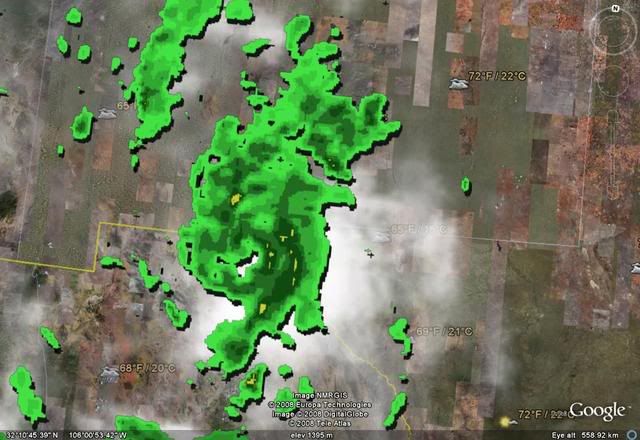
Nice circulation seen on El Paso radar for a remnant low.


El Paso gets about a foot of rain per year, IIRC, most of the folks there probably don't mind a rainy Saturday.
0 likes   

Ed Mahmoud

Re: ATL: Tropical Depression Dolly

#8406 Postby Ed Mahmoud » Sat Jul 26, 2008 8:11 am

From El Paso forecast office. Notice the comment from the Department of Redundancy Department


...FLASH FLOOD WATCH NOW IN EFFECT THROUGH SUNDAY AFTERNOON...

THE FLASH FLOOD WATCH IS NOW IN EFFECT FOR

* PORTIONS OF NEW MEXICO AND SOUTHWEST TEXAS...INCLUDING THE
FOLLOWING AREAS...IN NEW MEXICO...SIERRA COUNTY LAKES REGION...
SOUTHERN DESERT...SOUTHERN SACRAMENTO MOUNTAINS...SOUTHWEST
DESERT/BOOTHEEL...SOUTHWEST DESERT/MIMBRES BASIN...SOUTHWEST
MOUNTAINS/LOWER GILA REGION AND TULAROSA BASIN/SOUTHERN
DESERT. IN SOUTHWEST TEXAS...EL PASO AND HUDSPETH.

* THROUGH SUNDAY AFTERNOON

* MOIST TROPICAL MOISTURE IS LIKELY TO PRODUCE ISOLATED AREAS OF
HEAVY RAINFALL AND POSSIBLE FLOODING.

* FLOODING OF ARROYOS AND URBAN AREAS ARE POSSIBLE. ALSO CERTAIN
AREAS SUCH AS DEMING HAVE HAD SIGNIFICANT RAINFALL EVENTS IN
THE PAST WEEK AND THIS ADDITIONAL EXPECTED RAINFALL WILL NOT
BE ABSORBED AS EFFECTIVELY AND HENCE INCREASE THE RUNOFF OF
RAIN.

0 likes   

User avatar
HURAKAN
Professional-Met
Professional-Met
Posts: 46086
Age: 37
Joined: Thu May 20, 2004 4:34 pm
Location: Key West, FL
Contact:

#8407 Postby HURAKAN » Sat Jul 26, 2008 8:20 am

:uarrow: Have you ever heard of dry tropical moisture?!?!?!? :lol: :lol: :lol:
0 likes   

User avatar
Category 5
Category 5
Category 5
Posts: 10074
Age: 34
Joined: Sun Feb 11, 2007 10:00 pm
Location: New Brunswick, NJ
Contact:

Re:

#8408 Postby Category 5 » Sat Jul 26, 2008 8:54 am

HURAKAN wrote::uarrow: Have you ever heard of dry tropical moisture?!?!?!? :lol: :lol: :lol:


In bizzaro world. :wink:
0 likes   

User avatar
Category 5
Category 5
Category 5
Posts: 10074
Age: 34
Joined: Sun Feb 11, 2007 10:00 pm
Location: New Brunswick, NJ
Contact:

Re: ATL: Tropical Depression Dolly

#8409 Postby Category 5 » Sat Jul 26, 2008 8:55 am

Ed Mahmoud wrote:JB's rant today said official wind for Dolly, at 964 mb, was the lowest wind for that pressure ever in Gulf of Mexico, and no matter what anyone says, he is convinced that it made landfall between 100 and 105 mph, and somehow nobody measured the peak wind.


The peak winds hit bare stretch of SPI, but recon was in the storm the whole time. He has no basis for this. All the reports seem to agree that it was no stronger the 85kts, maybe weaker.
0 likes   

MBryant
Category 1
Category 1
Posts: 416
Joined: Fri Aug 27, 2004 7:13 pm
Location: Orange, Texas

Re: ATL: Tropical Depression Dolly

#8410 Postby MBryant » Sat Jul 26, 2008 9:39 am

I have questions rather than answers.

Concerning the low pressure verses the lower recorded wind speeds:

1. In a storm like Dolly, is it possible that it takes time for the winds to catch up to the pressure? This would lead to speculation that lower pressure is causal, rather than and effect of wind speed.

2. Has this association been studied and what conclusions, if any, have been reached and with what degree of certainty?

3. In some storm, there appear to be several smaller cyclones within the eyewall. (Meso's?) How would dropping a windsond into one of these cyclones cause a variation from typical readings in a storms strength profile?

I would really appreciate a patient response since I know just enough to ask some really dumb questions. This comes from years of studying on the fringes of knowledge.
0 likes   

User avatar
Chacor
Category 5
Category 5
Posts: 10229
Joined: Mon Oct 02, 2006 10:43 pm
Location: Singapore

Re: ATL: Tropical Depression Dolly

#8411 Postby Chacor » Sat Jul 26, 2008 9:50 am

MBryant wrote:2. Has this association been studied and what conclusions, if any, have been reached and with what degree of certainty?


I am able to scratch the surface with this question.

I'm not sure if you mean the association between lower pressures and high wind speeds trying to catch up, or the wind-pressure association in general. If the latter, Atkinson and Holliday (1974) published a paper on the relationship between wind and pressure, and this technique has been used by the Joint Typhoon Warning Centre in their warnings when they were in charge of the West Pacific warnings.
0 likes   

User avatar
HURAKAN
Professional-Met
Professional-Met
Posts: 46086
Age: 37
Joined: Thu May 20, 2004 4:34 pm
Location: Key West, FL
Contact:

#8412 Postby HURAKAN » Sat Jul 26, 2008 9:54 am

Image

Over El Paso, TX, and Juárez, México.
0 likes   

User avatar
Chacor
Category 5
Category 5
Posts: 10229
Joined: Mon Oct 02, 2006 10:43 pm
Location: Singapore

#8413 Postby Chacor » Sat Jul 26, 2008 10:01 am

Not often you get advisories on Atlantic storms issued in Mountain Time, heh.
0 likes   

User avatar
jasons2k
Storm2k Executive
Storm2k Executive
Posts: 8077
Age: 50
Joined: Wed Jul 06, 2005 12:32 pm
Location: The Woodlands, TX

Re: ATL: Tropical Depression Dolly

#8414 Postby jasons2k » Sat Jul 26, 2008 2:13 pm

Dolly is like the energizer bunny, she just won't quit. El Paso may have some big flooding from this.
0 likes   

CrazyC83
Professional-Met
Professional-Met
Posts: 33393
Joined: Tue Mar 07, 2006 11:57 pm
Location: Deep South, for the first time!

#8415 Postby CrazyC83 » Sat Jul 26, 2008 2:15 pm

At this rate Dolly may regenerate in the EPAC...
0 likes   

User avatar
Jason_B
Category 2
Category 2
Posts: 503
Joined: Mon Jun 23, 2008 12:46 pm

Re: ATL: Tropical Depression Dolly

#8416 Postby Jason_B » Sat Jul 26, 2008 2:47 pm

:uarrow: Wouldn't be surprised, land is obviously not a big deal for her.
0 likes   

RL3AO
Moderator-Pro Met
Moderator-Pro Met
Posts: 16308
Joined: Thu Jun 14, 2007 10:03 pm
Location: NC

Re: ATL: Tropical Depression Dolly

#8417 Postby RL3AO » Sat Jul 26, 2008 2:58 pm

Jason_B wrote::uarrow: Wouldn't be surprised, land is obviously not a big deal for her.


Yes. It will emerge at 30N and form in 20C waters....
0 likes   

Ed Mahmoud

Re: ATL: Tropical Depression Dolly

#8418 Postby Ed Mahmoud » Sat Jul 26, 2008 3:06 pm

El Paso, with 1.46 inches of rain, (and still showers in area) has had about a months worth of rain in a day. Flash Flood Warnings issued for El Paso County in Texas and Doña Ana and Otero Counties in New Mexico.

.
0 likes   

Ed Mahmoud

Re: ATL: Tropical Depression Dolly

#8419 Postby Ed Mahmoud » Sat Jul 26, 2008 3:07 pm

I think forecast is for remants to open into a trough and start moving more Northward with low level flow.
0 likes   

User avatar
Matt-hurricanewatcher
Category 5
Category 5
Posts: 11649
Age: 38
Joined: Fri Nov 26, 2004 11:09 pm
Location: Portland,OR
Contact:

Re: ATL: Tropical Depression Dolly

#8420 Postby Matt-hurricanewatcher » Sat Jul 26, 2008 4:25 pm

It would be something if this thing made it into the Eastern Pacific near 30 north. Then reformed over super cold 20c water. Then let it recurve to the north if so. :P

I know it is not possible to form a cyclone in 20c waters. But Vince in storms like it come close. Also that subtropical cyclone that formed off the coast a few years ago was interesting.
0 likes   


Return to “2008”

Who is online

Users browsing this forum: No registered users and 110 guests