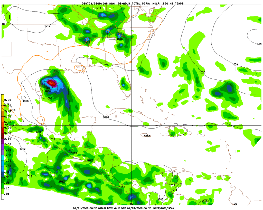
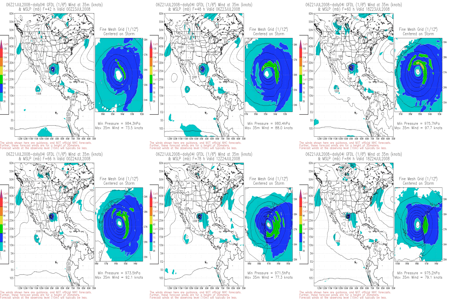
Is anyone having trouble viewing this image? I cant see anything?
ATL: Dolly Model Runs
Moderator: S2k Moderators
- HouTXmetro
- Category 5

- Posts: 3949
- Joined: Sun Jun 13, 2004 6:00 pm
- Location: District of Columbia, USA
Re: Re:
sphelps8681 wrote:
It shows models coming toward Houston and Beaumont/Pt. Arthur area. Is this correct. Because all I have been hearing is Mexico/S. Tex. Have these readjusted since Dolly made her trip over the Yuc.
Not really, ATM there is nothing for us in Houston to be worried about. We may get some Tropical downpours if that much.
0 likes
-
Smurfwicked
- Tropical Storm

- Posts: 160
- Age: 39
- Joined: Mon Sep 03, 2007 7:47 pm
- Location: SETX
Re: Re:
sphelps8681 wrote:It shows models coming toward Houston and Beaumont/Pt. Arthur area. Is this correct. Because all I have been hearing is Mexico/S. Tex. Have these readjusted since Dolly made her trip over the Yuc.
It currently shows one single model out of very many making landfall the BMT/PA area. I think we still need to wait for Dolly to develop further before models come to more of a agreement on the track.
Which IMO as non professional that knows nothing about this stuff, but I think most of these models will favor the center of texas coastline when they update.
0 likes
- Extremeweatherguy
- Category 5

- Posts: 11095
- Joined: Mon Oct 10, 2005 8:13 pm
- Location: Houston, TX
-
PauleinHouston
- Tropical Storm

- Posts: 102
- Joined: Mon Aug 13, 2007 10:23 am
- Location: League City, TX
- Contact:
Re: ATL: TS Dolly Model Runs
Agreed. Recon hasn't found a good westerly wind component as yet, however, MLC appears to be in control at the time. When the LLC reforms, I think it will do so farther north and lay the models out more towards mid-Texas coast and points south.
0 likes
- HouTXmetro
- Category 5

- Posts: 3949
- Joined: Sun Jun 13, 2004 6:00 pm
- Location: District of Columbia, USA
Re: ATL: TS Dolly Model Runs
PauleinHouston wrote:Agreed. Recon hasn't found a good westerly wind component as yet, however, MLC appears to be in control at the time. When the LLC reforms, I think it will do so farther north and lay the models out more towards mid-Texas coast and points south.
I think the LLC is forming beneath the MLC right now.
0 likes
Re: ATL: TS Dolly Model Runs
quote="HouTXmetro"]
I think the LLC is forming beneath the MLC right now.[/quote]
Where is the MLC right now?
PauleinHouston wrote:Agreed. Recon hasn't found a good westerly wind component as yet, however, MLC appears to be in control at the time. When the LLC reforms, I think it will do so farther north and lay the models out more towards mid-Texas coast and points south.
I think the LLC is forming beneath the MLC right now.[/quote]
Where is the MLC right now?
0 likes
-
PauleinHouston
- Tropical Storm

- Posts: 102
- Joined: Mon Aug 13, 2007 10:23 am
- Location: League City, TX
- Contact:
Re: ATL: TS Dolly Model Runs
I think the LLC is forming beneath the MLC right now.[/quote]
Think you're right and also note the recons flight path...been east/west oriented and they're moving more northerly now in subsequent passes...will be interesting to see if they get any W/SW wind components if they continue moving northerly.
Amendment...well, they turned south, lol
Think you're right and also note the recons flight path...been east/west oriented and they're moving more northerly now in subsequent passes...will be interesting to see if they get any W/SW wind components if they continue moving northerly.
Amendment...well, they turned south, lol
Last edited by PauleinHouston on Mon Jul 21, 2008 7:35 am, edited 1 time in total.
0 likes
- cycloneye
- Admin

- Posts: 139090
- Age: 67
- Joined: Thu Oct 10, 2002 10:54 am
- Location: San Juan, Puerto Rico
Re: ATL: TS Dolly Model Runs
Between Brownsville and Corpus Christi is now the GFDL latest landfall track.


0 likes
- HouTXmetro
- Category 5

- Posts: 3949
- Joined: Sun Jun 13, 2004 6:00 pm
- Location: District of Columbia, USA
- srainhoutx
- S2K Supporter

- Posts: 6919
- Age: 66
- Joined: Sun Jan 14, 2007 11:34 am
- Location: Haywood County, NC
- Contact:
Re: ATL: TS Dolly Model Runs
I know I'll get blasted for this, but the NAM is in about the same area...See Ed, you're not the only one that looks at the NAM. 


Last edited by srainhoutx on Mon Jul 21, 2008 8:18 am, edited 1 time in total.
0 likes
- cycloneye
- Admin

- Posts: 139090
- Age: 67
- Joined: Thu Oct 10, 2002 10:54 am
- Location: San Juan, Puerto Rico
Re: ATL: TS Dolly Model Runs
The BAMS are also with GFDL and HWRF more north.
WHXX01 KWBC 211244
CHGHUR
TROPICAL CYCLONE GUIDANCE MESSAGE
NWS TPC/NATIONAL HURRICANE CENTER MIAMI FL
1244 UTC MON JUL 21 2008
DISCLAIMER...NUMERICAL MODELS ARE SUBJECT TO LARGE ERRORS.
PLEASE REFER TO NHC OFFICIAL FORECASTS FOR TROPICAL CYCLONE
AND SUBTROPICAL CYCLONE INFORMATION.
ATLANTIC OBJECTIVE AIDS FOR
TROPICAL CYCLONE DOLLY (AL042008) 20080721 1200 UTC
...00 HRS... ...12 HRS... ...24 HRS. .. ...36 HRS...
080721 1200 080722 0000 080722 1200 080723 0000
LAT LON LAT LON LAT LON LAT LON
BAMS 21.6N 88.7W 22.8N 91.0W 24.5N 93.1W 26.1N 94.8W
BAMD 21.6N 88.7W 22.7N 90.7W 24.0N 92.2W 25.6N 93.5W
BAMM 21.6N 88.7W 22.8N 90.8W 24.1N 92.7W 25.7N 94.2W
LBAR 21.6N 88.7W 22.8N 91.3W 24.0N 93.7W 25.4N 95.6W
SHIP 45KTS 50KTS 57KTS 64KTS
DSHP 45KTS 50KTS 57KTS 64KTS
...48 HRS... ...72 HRS... ...96 HRS. .. ..120 HRS...
080723 1200 080724 1200 080725 1200 080726 1200
LAT LON LAT LON LAT LON LAT LON
BAMS 27.2N 96.7W 27.4N 100.9W 26.6N 105.9W 26.4N 110.3W
BAMD 26.9N 94.5W 28.3N 97.3W 29.4N 101.7W 31.8N 105.8W
BAMM 26.9N 95.6W 28.1N 99.4W 28.9N 104.5W 31.1N 108.8W
LBAR 26.7N 96.9W 28.6N 98.0W 29.9N 99.0W 30.7N 100.3W
SHIP 68KTS 73KTS 75KTS 70KTS
DSHP 68KTS 38KTS 28KTS 27KTS
...INITIAL CONDITIONS...
LATCUR = 21.6N LONCUR = 88.7W DIRCUR = 300DEG SPDCUR = 16KT
LATM12 = 20.0N LONM12 = 85.9W DIRM12 = 314DEG SPDM12 = 17KT
LATM24 = 17.9N LONM24 = 83.5W
WNDCUR = 45KT RMAXWD = 75NM WNDM12 = 45KT
CENPRS = 1005MB OUTPRS = 1012MB OUTRAD = 180NM SDEPTH = M
RD34NE = 150NM RD34SE = 150NM RD34SW = 0NM RD34NW = 150NM
0 likes
Re: ATL: TS Dolly Model Runs
A snippet from the recon in last report
12:30:30Z 22.58N 87.22W 957.7 mb
(~ 28.28 inHg) 482 meters
(~ 1,581 feet) 1011.5 mb
(~[b] 29.87 inHg) - From 135° at 57 knots
(From the SE at ~ 65.5 mph[/b]) 23.9°C
(~ 75.0°F) 19.0°C
(~ 66.2°F) 58 knots
(~ 66.7 mph) 36 knots
FLIGHT LEVEL
I don't think they have closed off LLC yet though.
12:30:30Z 22.58N 87.22W 957.7 mb
(~ 28.28 inHg) 482 meters
(~ 1,581 feet) 1011.5 mb
(~[b] 29.87 inHg) - From 135° at 57 knots
(From the SE at ~ 65.5 mph[/b]) 23.9°C
(~ 75.0°F) 19.0°C
(~ 66.2°F) 58 knots
(~ 66.7 mph) 36 knots
FLIGHT LEVEL
I don't think they have closed off LLC yet though.
Last edited by tailgater on Mon Jul 21, 2008 7:56 am, edited 1 time in total.
0 likes
- DESTRUCTION5
- Category 5

- Posts: 4391
- Age: 42
- Joined: Wed Sep 03, 2003 11:25 am
- Location: Stuart, FL
- HouTXmetro
- Category 5

- Posts: 3949
- Joined: Sun Jun 13, 2004 6:00 pm
- Location: District of Columbia, USA
-
christoddwhitmer
- Tropical Wave

- Posts: 4
- Joined: Tue Jul 15, 2008 10:04 pm
6Z 7-21-2008 GFDL ~ Dolly
6Z 7-21-2008 GFDL ~ Dolly
[b]The posts in this forum are NOT official forecast and should not be used as such. They are just the opinion of the poster and may or may not be backed by sound meteorological data. They are NOT endorsed by any professional institution or storm2k.org. For official information, please refer to the NHC and NWS products.

http://christodd.ipower.com/portals/ind ... 2&start=42
[b]The posts in this forum are NOT official forecast and should not be used as such. They are just the opinion of the poster and may or may not be backed by sound meteorological data. They are NOT endorsed by any professional institution or storm2k.org. For official information, please refer to the NHC and NWS products.

http://christodd.ipower.com/portals/ind ... 2&start=42
0 likes
Who is online
Users browsing this forum: No registered users and 93 guests


