ATL: Invest 97L in Central Atlantic
Moderator: S2k Moderators
-
SapphireSea
- Category 1

- Posts: 430
- Joined: Wed Aug 24, 2005 12:13 pm
- Location: Miami, FL
Re: ATL: Invest 97L in Central Atlantic
Sounds about right at 18.5/19n, fact of the matter is, that there is still pretty good shear on the system, and it has some ways to go before conditions get more favorable. Even if it does get its act together, it seems unlikely to be a US landmass threat. Ridging hasn't been too strong this July, and I could tell since we have been having a lot of SWsterly storm steering days in S. FL.
0 likes
-
cycloneye

- Admin

- Posts: 139083
- Age: 67
- Joined: Thu Oct 10, 2002 10:54 am
- Location: San Juan, Puerto Rico
Re: ATL: Invest 97L in Central Atlantic
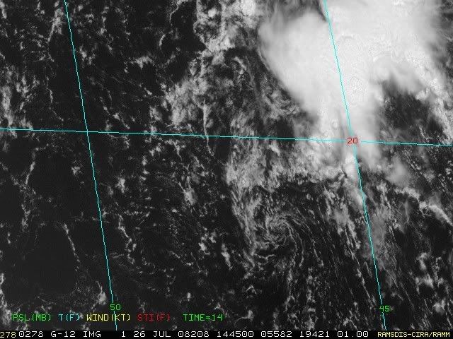
Floater 1 is on top of 97L: Convection forming near the LLC:

0 likes

Re: ATL: Invest 97L in Central Atlantic
tailgater wrote:Please take a look at this satellite loop and tell where the Low(center) is located?
http://hadar.cira.colostate.edu/ramsdis ... at1_0.html
GCANE wrote The Surface low is at ~12N 41W
and then wrote
I think the deceiving part of this is that circulation goes all the way from the surface to about 500mb. The 500mb circulation is centered at about 18N 41W while the surface is what QSCAT is showing at 12N 41W.
You nailed it, I was gonna try and show that there two things to watch here but I had to leave to make a run to P.A. Texas.
0 likes
Re: ATL: Invest 97L in Central Atlantic
Still a fairly defined low @ 13.5n 44W
http://manati.orbit.nesdis.noaa.gov/dat ... Bds112.png
http://manati.orbit.nesdis.noaa.gov/dat ... Bds112.png
0 likes
-
cheezyWXguy

- Category 5

- Posts: 5534
- Joined: Mon Feb 13, 2006 12:29 am
- Location: Dallas, TX
Re: ATL: Invest 97L in Central Atlantic
tailgater wrote:Still a fairly defined low @ 13.5n 44W
http://manati.orbit.nesdis.noaa.gov/dat ... Bds112.png
That is extremely weak and I cant believe it even exists...absolutely no satellite data I have seen all day shows any circulation down there. I see what appears to be a closed llc at 18N with convection popping right around it now.
0 likes
Re: ATL: Invest 97L in Central Atlantic
cheezyWXguy wrote:tailgater wrote:Still a fairly defined low @ 13.5n 44W
http://manati.orbit.nesdis.noaa.gov/dat ... Bds112.png
That is extremely weak and I cant believe it even exists...absolutely no satellite data I have seen all day shows any circulation down there. I see what appears to be a closed llc at 18N with convection popping right around it now.
Weak yes but it starting to get a little convection, and what looks like an LLC @ 18N isn't down to the surface per Qickscat.
0 likes
-
Aric Dunn
- Category 5
- Posts: 21228
- Age: 41
- Joined: Sun Sep 19, 2004 9:58 pm
- Location: Ready for the Chase.
- Contact:
Re: ATL: Invest 97L in Central Atlantic
cheezyWXguy wrote:tailgater wrote:Still a fairly defined low @ 13.5n 44W
http://manati.orbit.nesdis.noaa.gov/dat ... Bds112.png
That is extremely weak and I cant believe it even exists...absolutely no satellite data I have seen all day shows any circulation down there. I see what appears to be a closed llc at 18N with convection popping right around it now.
yeah i cant find anything down there just the southern extent of the wave axis.. the low at 18n will likely develop a more possibly making to a depression in a couple days.. depending on what happens with this burst of convection tonight will determine the short term life of the system.
http://www.ssd.noaa.gov/goes/east/tatl/loop-ir2.html
0 likes
-
catastrophic

- Tropical Low

- Posts: 35
- Joined: Wed Jul 23, 2008 1:50 pm
- Location: palm bay FL


Re: ATL: Invest 97L in Central Atlantic
TROPICAL WEATHER OUTLOOK
NWS TPC/NATIONAL HURRICANE CENTER MIAMI FL
200 AM EDT SAT JUL 26 2008
FOR THE NORTH ATLANTIC...CARIBBEAN SEA AND THE GULF OF MEXICO...
THE HYDROMETEOROLOGICAL PREDICTION CENTER IS ISSUING ADVISORIES ON
THE REMNANTS OF TROPICAL DEPRESSION DOLLY...LOCATED INLAND ABOUT 85
MILES WEST-NORTHWEST OF PRESIDIO TEXAS.
AN AREA OF DISTURBED WEATHER...ASSOCIATED WITH A WELL-DEFINED
TROPICAL WAVE...IS LOCATED OVER THE CENTRAL ATLANTIC ABOUT 1150
MILES EAST OF THE LEEWARD ISLANDS. UPPER-LEVEL WINDS ARE CURRENTLY
NOT FAVORABLE FOR DEVELOPMENT...AND SHOWER ACTIVITY WITH THIS
DISTURBANCE REMAINS DISORGANIZED. HOWEVER...CONDITIONS COULD BECOME
A LITTLE MORE FAVORABLE FOR DEVELOPMENT OVER THE NEXT COUPLE OF
DAYS AS THE DISTURBANCE MOVES GENERALLY NORTHWESTWARD AT 15-20 MPH.
ELSEWHERE...TROPICAL CYCLONE FORMATION IS NOT EXPECTED DURING THE
NEXT 48 HOURS.
$$
FORECASTER KNABB
**********
TROPICAL WEATHER DISCUSSION
NWS TPC/NATIONAL HURRICANE CENTER MIAMI FL
205 AM EDT SAT JUL 26 2008
...
AN ATLANTIC OCEAN TROPICAL WAVE IS ALONG 43W/44W SOUTH OF 24N
MOVING WEST 15 TO 20 KT. A 1012 MB LOW PRESSURE CENTER IS ALONG
THE WAVE NEAR 19N. AN UPPER LEVEL TROUGH AND CYCLONIC CIRCULATION
CENTER CONTINUE TO BE MOVING WESTWARD ON TOP OF THIS WAVE.
STRONG SHOWERS AND THUNDERSTORMS IN INDIVIDUAL CELLS ARE FROM
19N TO 20N BETWEEN 44W AND 45W. ISOLATED MODERATE SHOWERS ARE
ELSEWHERE FROM 20N TO 25N BETWEEN 40W AND 47W.
...
$$
MT
NWS TPC/NATIONAL HURRICANE CENTER MIAMI FL
200 AM EDT SAT JUL 26 2008
FOR THE NORTH ATLANTIC...CARIBBEAN SEA AND THE GULF OF MEXICO...
THE HYDROMETEOROLOGICAL PREDICTION CENTER IS ISSUING ADVISORIES ON
THE REMNANTS OF TROPICAL DEPRESSION DOLLY...LOCATED INLAND ABOUT 85
MILES WEST-NORTHWEST OF PRESIDIO TEXAS.
AN AREA OF DISTURBED WEATHER...ASSOCIATED WITH A WELL-DEFINED
TROPICAL WAVE...IS LOCATED OVER THE CENTRAL ATLANTIC ABOUT 1150
MILES EAST OF THE LEEWARD ISLANDS. UPPER-LEVEL WINDS ARE CURRENTLY
NOT FAVORABLE FOR DEVELOPMENT...AND SHOWER ACTIVITY WITH THIS
DISTURBANCE REMAINS DISORGANIZED. HOWEVER...CONDITIONS COULD BECOME
A LITTLE MORE FAVORABLE FOR DEVELOPMENT OVER THE NEXT COUPLE OF
DAYS AS THE DISTURBANCE MOVES GENERALLY NORTHWESTWARD AT 15-20 MPH.
ELSEWHERE...TROPICAL CYCLONE FORMATION IS NOT EXPECTED DURING THE
NEXT 48 HOURS.
$$
FORECASTER KNABB
**********
TROPICAL WEATHER DISCUSSION
NWS TPC/NATIONAL HURRICANE CENTER MIAMI FL
205 AM EDT SAT JUL 26 2008
...
AN ATLANTIC OCEAN TROPICAL WAVE IS ALONG 43W/44W SOUTH OF 24N
MOVING WEST 15 TO 20 KT. A 1012 MB LOW PRESSURE CENTER IS ALONG
THE WAVE NEAR 19N. AN UPPER LEVEL TROUGH AND CYCLONIC CIRCULATION
CENTER CONTINUE TO BE MOVING WESTWARD ON TOP OF THIS WAVE.
STRONG SHOWERS AND THUNDERSTORMS IN INDIVIDUAL CELLS ARE FROM
19N TO 20N BETWEEN 44W AND 45W. ISOLATED MODERATE SHOWERS ARE
ELSEWHERE FROM 20N TO 25N BETWEEN 40W AND 47W.
...
$$
MT
0 likes
-
fasterdisaster
- Category 5
- Posts: 1868
- Joined: Mon Sep 19, 2005 4:41 pm
- Location: Miami, Florida
-
SouthFloridawx

- S2K Supporter

- Posts: 8344
- Age: 45
- Joined: Tue Jul 26, 2005 1:16 am
- Location: Sarasota, FL
- Contact:


-
Matt-hurricanewatcher

- Category 5
- Posts: 11649
- Age: 38
- Joined: Fri Nov 26, 2004 11:09 pm
- Location: Portland,OR
- Contact:
Re: ATL: Invest 97L in Central Atlantic
18.2 north/45.7 west is the center of the LLC. Still very strong shear. If this shear weakens this could become a "depression" within the next 36 hours.
0 likes
-
cycloneye
- Admin
- Posts: 139083
- Age: 67
- Joined: Thu Oct 10, 2002 10:54 am
- Location: San Juan, Puerto Rico
Re: ATL: Invest 97L in Central Atlantic
ABNT20 KNHC 261135
TWOAT
TROPICAL WEATHER OUTLOOK
NWS TPC/NATIONAL HURRICANE CENTER MIAMI FL
800 AM EDT SAT JUL 26 2008
FOR THE NORTH ATLANTIC...CARIBBEAN SEA AND THE GULF OF MEXICO...
THE HYDROMETEOROLOGICAL PREDICTION CENTER IS ISSUING PUBLIC
ADVISORIES ON THE REMNANTS OF TROPICAL DEPRESSION DOLLY...LOCATED
INLAND ABOUT 110 MILES SOUTH OF EL PASO TEXAS.
AN AREA OF DISTURBED WEATHER...ASSOCIATED WITH A WELL-DEFINED
TROPICAL WAVE...IS LOCATED OVER THE CENTRAL ATLANTIC ABOUT 1050
MILES EAST OF THE LEEWARD ISLANDS. SHOWER ACTIVITY WITH THIS
DISTURBANCE REMAINS DISORGANIZED...AND CONDITIONS APPEAR ONLY
MARGINALLY FAVORABLE FOR SLOW DEVELOPMENT DURING THE NEXT COUPLE OF
DAYS AS THE SYSTEM MOVES GENERALLY NORTHWESTWARD AT 15 TO 20 MPH.
ELSEWHERE...TROPICAL CYCLONE FORMATION IS NOT EXPECTED DURING THE
NEXT 48 HOURS.
$$
FORECASTER KNABB
0 likes
Re: ATL: Invest 97L in Central Atlantic
Matt-hurricanewatcher wrote:18.2 north/45.7 west is the center of the LLC. Still very strong shear. If this shear weakens this could become a "depression" within the next 36 hours.
Still doesn't seem to be at the surface.

The weak low further south should start gaining some convection today. It may have opened up already, quickscat misses it this morning.
0 likes

Re: ATL: Invest 97L in Central Atlantic
You have to hand it to the GFS it showed this very scenario in the 850MB steering thursday night with the northern part taking control. I thought the southern part with the Low would win out.As stated above the southern part should open up as per the GFS and allow the northern vort to tighten up.
0 likes
-
cycloneye
- Admin
- Posts: 139083
- Age: 67
- Joined: Thu Oct 10, 2002 10:54 am
- Location: San Juan, Puerto Rico
Re: ATL: Invest 97L in Central Atlantic
ATCF best track ar 12z:
AL, 97, 2008072612, , BEST, 0, 190N, 465W, 25, 1010, DB, 34, NEQ, 0, 0, 0, 0, 1012, 120, 25, 0, 0,
AL, 97, 2008072612, , BEST, 0, 190N, 465W, 25, 1010, DB, 34, NEQ, 0, 0, 0, 0, 1012, 120, 25, 0, 0,
0 likes
Re: ATL: Invest 97L in Central Atlantic
Rule of thumb is if it can keep a small convection tag while weak and sheared it should develop if conditions improve. Looks like this one ate up the African wave instead of the reverse (not sure).
Weak exposed LLC just jumped into recurve as gatorcane was saying yesterday from the models. So much for my closer to the coast recurve forecast.
Weak exposed LLC just jumped into recurve as gatorcane was saying yesterday from the models. So much for my closer to the coast recurve forecast.
0 likes


-
canetracker

- S2K Supporter
- Posts: 746
- Age: 61
- Joined: Wed Jul 27, 2005 8:49 pm
- Location: Suburbia New Orleans...Harahan, LA

Who is online
Users browsing this forum: No registered users and 106 guests