
BEGIN
NHC
invest_al922008.invest
FSTDA
R
U
040
010
0000
200808101044
NONE
NOTIFY=ATRP
END
INVEST, AL, L, , , , , 92, 2008, DB, O, 2008081006, 9999999999, , , , , , METWATCH, , AL922008
AL, 92, 2008081006, , BEST, 0, 108N, 413W, 25, 0, DB, 0, , 0, 0, 0, 0,
ATL: Tropical Depression Fay
Moderator: S2k Moderators
ATL: Tropical Depression Fay
0 likes
-
Matt-hurricanewatcher

- Category 5

- Posts: 11649
- Age: 38
- Joined: Fri Nov 26, 2004 11:09 pm
- Location: Portland,OR
- Contact:
Re: ATL: Invest 92L - Central Atlantic
The systems are not far away from each other. But this has a closed LLC.
0 likes
-
Matt-hurricanewatcher
- Category 5
- Posts: 11649
- Age: 38
- Joined: Fri Nov 26, 2004 11:09 pm
- Location: Portland,OR
- Contact:
Re: ATL: Invest 92L - Central Atlantic
Just think if both of these systems 92L and the system behind it moved westward into the Caribbean. Both Stayed at least 10-12 degree's or 600-720 nmi away from each other...I believe that would be a wide enough area for both to have a chance to become very interesting. Then both of them follow each other into the Gulf.
Now this is just thinking with no facts. I would not say no facts but it is a thought excise.
As for this system I believe it is close to depression strength. Quickscat supports that with a closed LLC and 25 knot winds.
Now this is just thinking with no facts. I would not say no facts but it is a thought excise.
As for this system I believe it is close to depression strength. Quickscat supports that with a closed LLC and 25 knot winds.
0 likes
-
Matt-hurricanewatcher
- Category 5
- Posts: 11649
- Age: 38
- Joined: Fri Nov 26, 2004 11:09 pm
- Location: Portland,OR
- Contact:
Re: ATL: Invest 92L - Central Atlantic
I think this will be the second peak and main peak of the 2008 season. Maybe 4 weeks? Maybe 5???
0 likes
-
cycloneye

- Admin

- Posts: 139082
- Age: 67
- Joined: Thu Oct 10, 2002 10:54 am
- Location: San Juan, Puerto Rico
Re: ATL: Invest 92L - Central Atlantic
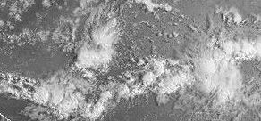
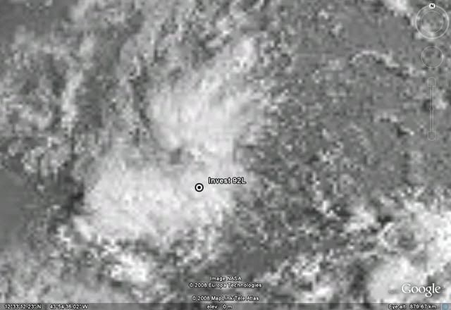
This pass was made at 4:41 AM EDT.Look at the circulation how good it looks:

0 likes
-
HURAKAN

- Professional-Met

- Posts: 46086
- Age: 37
- Joined: Thu May 20, 2004 4:34 pm
- Location: Key West, FL
- Contact:
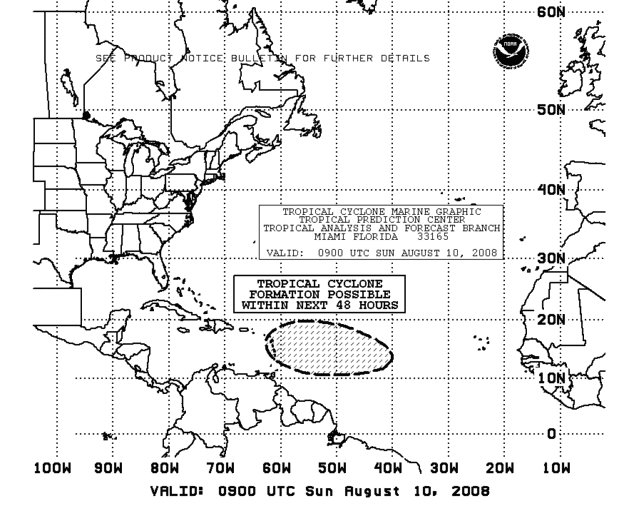
TROPICAL WEATHER DISCUSSION
NWS TPC/NATIONAL HURRICANE CENTER MIAMI FL
805 AM EDT SUN AUG 10 2008
BASED ON 0600 UTC SURFACE ANALYSIS AND SATELLITE IMAGERY THROUGH
1015 UTC.
...SPECIAL FEATURES...
THE TROPICAL WAVE ALONG 41W S OF 19N IS MOVING W NEAR 15 KT. IR
SATELLITE IMAGERY EXHIBITS A CYCLONIC TURNING OBSERVED ALONG THE
WAVE AXIS NEAR 11N. AN EARLIER SCATTEROMETER PASS AT 0840Z
CONFIRMS POSITION OF THE WAVE ALONG WITH A POSSIBLE CLOSED LOW
CIRCULATION FORMING ALONG THE WAVE AXIS. CONVECTIVE ACTIVITY
ASSOCIATED WITH THIS WAVE REMAINS DISORGANIZED WITH SCATTERED
MODERATE CONVECTION WEST OF THE WAVE AXIS FROM 9N-13N BETWEEN
42W-45W. UPPER LEVEL ENVIRONMENTAL WINDS ARE EXPECTED TO BECOME
MORE FAVORABLE FOR DEVELOPMENT OF THIS SYSTEM DURING THE NEXT
COUPLE OF DAYS.
0 likes
-
alan1961

- Category 2

- Posts: 767
- Joined: Mon Mar 20, 2006 11:58 am
- Location: Derby, Derbyshire, England
- Contact:
Re: ATL: Invest 92L - Central Atlantic
Mecklenburg wrote:not yet in the navy site...
there it is
http://www.nrlmry.navy.mil/tc_pages/tc_home.html
0 likes

-
carolina_73

- Tropical Storm

- Posts: 148
- Joined: Wed Jul 23, 2008 1:30 am
Re: ATL: Invest 92L - Central Atlantic
If we keep getting these impressive waves coming off of Africa I am afraid we are headed for some busy and sleepless nights ahead of us. We have not seen a real busy Cape Verde type season in awhile. I sure hope a nice TS hits the Carolinas and brings alot of well needed rain to the drought. The Carolinas are due for some active tropics. 92L should become a depression in the near future. It looks real good. Any models hinting yet where this could be heading?
0 likes

-
Mecklenburg
Re: ATL: Invest 92L - Central Atlantic
carolina_73 wrote:If we keep getting these impressive waves coming off of Africa I am afraid we are headed for some busy and sleepless nights ahead of us. We have not seen a real busy Cape Verde type season in awhile. I sure hope a nice TS hits the Carolinas and brings alot of well needed rain to the drought. The Carolinas are due for some active tropics. 92L should become a depression in the near future. It looks real good. Any models hinting yet where this could be heading?
yeah, the last busy CV season was 2004... but then again if there are so much waves, they clump the atlantic and may hinder the development of each other...
0 likes


Who is online
Users browsing this forum: No registered users and 116 guests