
Off to bed - we'll know more by the time I start my PC and my first coffee tomorrow morning.
92L NE Caribbean / Preparations / Observations / Web Cams
Moderator: S2k Moderators

-
knotimpaired

- Category 1

- Posts: 495
- Joined: Fri May 20, 2005 4:14 am
- Location: Vieques, PR
- Contact:
Personally I am getting tired of this 92 crap. I wake up because of rain on our tin roof (can you believe I once thought this romantic) and I see pop ups flying in from the NE but no squall lines.
Then I think of Bob who runs Hix Island House going to Boston today, Veronica who at 76 is flying to New Orleans today to spend about 10 days with her daughter from Ariz, MJ going everywhere and the list goes on. This is the time for everyone to go off island and the weather is not cooperating....
No let me back that up. 92 is heading our way but through all of the threads here I see nothing that says really anything. Maybe this, maybe that.
Well maybe I can just go back to bed and wake up in a few days and report everyone made it off island and we got a bit of rain.
Thats it, wake me when it is over.
0 likes
-
knotimpaired
- Category 1
- Posts: 495
- Joined: Fri May 20, 2005 4:14 am
- Location: Vieques, PR
- Contact:
Re: 92L NE Caribbean / Observations / Preparations / Web Cams
AMZ730-142230-
CARIB WATERS FROM PUNTA VIENTO TO CABO SAN JUAN S TO 17N AND E TO
64W INCLUDING THE CARIB WATERS OF CULEBRA VIEQUES AND THE U.S.
VIRGIN ISLANDS-
449 AM AST THU AUG 14 2008
SMALL CRAFT SHOULD EXERCISE CAUTION
This is the latest for the seas.
Please note that the wind will be WEST SOUTHWEST when you prep for this
TODAY
NORTHEAST WINDS 14 TO 19 KNOTS. SEAS 3 TO 5 FEET. SCATTERED
SHOWERS AND ISOLATED THUNDERSTORMS.
TONIGHT
NORTH WINDS 14 TO 19 KNOTS SHIFTING TO THE WEST SOUTHWEST
23 TO 28 KNOTS AFTER MIDNIGHT. SEAS 3 TO 5 FEET. SCATTERED SHOWERS
AND ISOLATED THUNDERSTORMS.
FRIDAY
SOUTH WINDS 16 TO 21 KNOTS. SEAS 4 TO 5 FEET. SCATTERED
SHOWERS AND ISOLATED THUNDERSTORMS.
0 likes
-
MiamiensisWx
Link to land based Caribbean observations (including Leewards/Puerto Rico) for all:
http://www.srh.noaa.gov/sju/caribm.html
http://www.srh.noaa.gov/sju/caribm.html
0 likes
-
Gustywind

- Category 5

- Posts: 12334
- Joined: Mon Sep 03, 2007 7:29 am
- Location: Baie-Mahault, GUADELOUPE
Re:
MiamiensisWx wrote:Link to land based Caribbean observations (including Leewards/Puerto Rico) for all:
http://www.srh.noaa.gov/sju/caribm.html
Tkanks for us MiamiensisWx
0 likes
-
Gustywind
- Category 5
- Posts: 12334
- Joined: Mon Sep 03, 2007 7:29 am
- Location: Baie-Mahault, GUADELOUPE
000
FXCA62 TJSJ 141016
AFDSJU
AREA FORECAST DISCUSSION
NATIONAL WEATHER SERVICE SAN JUAN PR
616 AM AST THU AUG 14 2008
.DISCUSSION...AN APPROACHING TROPICAL WAVE...NEARING 60 WEST THIS
MORNING...HAS EXPERIENCED A BURST IN CONVECTION OVERNIGHT.
CONVECTION OVERNIGHT HAS BECOME MORE ALIGNED WITH LOW LEVEL
CIRCULATION...WHICH WAS ESTIMATED TO BE LOCATED NEAR 17.3 N AND
59.3 WEST AT 06Z. WITH THIS BURST OF CONVECTION...AND THE WAVE
MOVING INTO A MORE FAVORABLE ENVIRONMENT FOR DEVELOPMENT...COULD
SEE THE LOW ASSOCIATED WITH THIS WAVE DEVELOP INTO A TROPICAL
DEPRESSION LATER TODAY.
FOR TODAY...EXPECT THE DRY SLOT OF AIR THAT MOVED ACROSS THE
LOCAL AREA OVERNIGHT...TO GRADUALLY SHIFT TO THE WEST OF THE LOCAL
AREA...AND FOR SUFFICIENT LOW LEVEL MOISTURE TO COMBINE WITH LOCAL
EFFECTS....RESULTING IN DIURNALLY DRIVEN CONVECTION OVER THE
INTERIOR AND SOUTHWESTERN SECTIONS OF THE ISLAND THIS AFTERNOON.
LATE IN THE DAY...EXPECT SHOWERS ASSOCIATED WITH THE APPROACHING
TROPICAL WAVE TO NEAR THE VI...BRINGING AN INCREASE IN
SHOWERS...THUNDERSTORM ACTIVITY AS WELL AS THE POTENTIAL FOR GUSTY
WINDS AND HEAVY RAINFALL TO THE REGION OVERNIGHT. LATEST NAM AND
GFS BOTH INDICATE THE BULK THE SHOWER ACTIVITY WILL BE TO THE
NORTH OF THE LOCAL ISLANDS...BUT STILL EXPECT SOME SIGNIFICANT
SHOWER ACTIVITY FOR THE VI AND AT LEAST NORTH COAST OF PUERTO RICO
DURING THE OVERNIGHT HOURS AND ON FRIDAY MORNING. AS THIS WAVE
PASSES BY THE LOCAL ISLANDS...EXPECT A SHIFT TO A SOUTHEASTERLY
WIND FLOW FOR AT LEAST THE FIRST HALF OF THE UPCOMING WEEKEND. A
SECOND TROPICAL WAVE...WITH A BROAD AREA OF CIRCULATION NEAR 40
WEST...WILL MOVE ACROSS THE LOCAL AREA EARLY NEXT WEEK...BUT
THE POTENTIAL FOR DEVELOPMENT OF THIS WAVE APPEARS LOW AT THIS
TIME...AS 00Z GFS...ECMWF AND UKMO ALL IN AGREEMENT NOT
DEVELOPING A CLOSED LOW CIRCULATION WITH THIS WAVE.
&&
.AVIATION...WEATHER CONDITIONS WILL DETERIORATE ACROSS ALL LOCAL
TERMINALS LATE TODAY AS A STRONG AND ACTIVE TROPICAL WAVE...NOW
LOCATED ABOUT 200 MILES EAST OF THE LEEWARDS ISLANDS...APPROACHES THE
REGION. THE OUTER BANDS OF THE SYSTEM WILL BEGIN TO AFFECT THE
TERMINALS OF TKPK AND TNCM LATE THIS MORNING. SHOWERS AND
THUNDERSTORMS ASSOCIATED TO THIS SYSTEM WILL CONTINUE TO PROPAGATE
WESTWARD AFFECTING REST OF THE LOCAL TERMINALS THIS EVENING AND OVERNIGHT.
SHOWERS AND THUNDERSTORMS IN THE FORM OF BANDS WILL RESULT IN
PERIODS OF LOW VISIBILITY...STRONG WINDS AND LIGHTNING. THEREFORE
EXPECT MVFR AND EVEN BRIEF IFR CONDITIONS ACROSS PR AND THE USVI
TERMINALS FROM EARLY THIS EVENING THROUGH FRIDAY MORNING.
&&
.PRELIMINARY POINT TEMPS/POPS...
SJU 89 78 89 78 / 50 50 50 40
STT 89 79 89 79 / 50 50 50 50
&&
.SJU WATCHES/WARNINGS/ADVISORIES...
PR...NONE.
VI...NONE.
&&
$$
10/04/
0 likes
-
Gustywind
- Category 5
- Posts: 12334
- Joined: Mon Sep 03, 2007 7:29 am
- Location: Baie-Mahault, GUADELOUPE
000
AWCA82 TJSJ 140908
RWSVI
WEATHER SUMMARY FOR THE U.S. VIRGIN ISLANDS
NATIONAL WEATHER SERVICE SAN JUAN PR
508 AM AST THU AUG 14 2008
VARIABLY CLOUDY SKIES WERE OBSERVED OVERNIGHT ACROSS THE U.S.
VIRGIN ISLANDS AND THE SURROUNDING COASTAL WATERS. THE NWS DOPPLER
RADAR INDICATED SCATTERED SHOWERS ACROSS THE COASTAL WATERS THIS
OVERNIGHT. HOWEVER...NO SIGNIFICANT PRECIPITATION WAS DETECTED OVER
THE LOCAL ISLANDS. THE WINDS WERE FROM THE NORTHEAST AT 10 TO 15
MPH.
TODAY...ISOLATED TO SCATTERED SHOWERS WILL CONTINUE TO AFFECT THE
LO CA ISLAND THIS MORNING. THESE SHOWERS ARE EXPECTED TO BECOME
MORE FREQUENT THROUGH LATE AFTERNOON. WEATHER CONDITIONS WILL QUICKLY
DETERIORATE STARTING EARLY THIS EVENING AS AN AREA OF LOW PRESSURE
ASSOCIATED WITH A TROPICAL WAVE WILL BEGIN TO MOVE ACROSS THE
LOCAL REGION. THE AXIS OF THE WAVE IS LOCATED ABOUT 175 MILES EAST
OF THE LEEWARD ISLANDS AND IS MOVING GENERALLY WESTWARD AT ABOUT
10 MPH. THIS TROPICAL WAVE COULD BECOME A TROPICAL DEPRESSION
LATER TODAY AND THEREFORE RESIDENTS AND VISITORS IN PUERTO RICO
SHOULD CLOSELY MONITOR ITS PROGRESS.
MARINE CONDITIONS WILL DETERIORATE MAINLY IN THE ATLANTIC...TONIGHT
AND FRIDAY WITH THE APPROACH OF THE TROPICAL WAVE. SHOWERS AND
THUNDERSTORMS IN THE FORM OF SQUALLS WILL BECOME MORE FREQUENT AS
THE SYSTEM MOVE CLOSER TO THE LOCAL AREA.
0 likes
-
knotimpaired
- Category 1
- Posts: 495
- Joined: Fri May 20, 2005 4:14 am
- Location: Vieques, PR
- Contact:
At least for Vieques we can still expect the west winds which helps us here at the house.
Hubby plays Dominoes at Al's Mar Azul every thursday at 4 pm with the owner and his mother and a forth (normally Chipper but he is in St Thomas for the week) which happens to be the only open-air bar in Isabel Segunda so I have decided once we are secure I am going to take my camera and go down with him.
It could be interesting or maybe a dud. We will wait and see.
0 likes
-
knotimpaired
- Category 1
- Posts: 495
- Joined: Fri May 20, 2005 4:14 am
- Location: Vieques, PR
- Contact:
Re: 92L NE Caribbean / Observations / Preparations / Web Cams
The middle gas station (Lebe's) now has gas. The Playa Monte Santo may also but that is a rumor, not confirmed.
We have been without for a few days so fill up now and bring your containers.
It probably will not last past noonish.
PS: Lebe is a neighbor
We have been without for a few days so fill up now and bring your containers.
It probably will not last past noonish.
PS: Lebe is a neighbor
0 likes

Re: 92L NE Caribbean / Observations / Preparations / Web Cams
This is becoming soo frustrating......
I watched our local news last night just to see what they might have to say about this storm.....when the forecaster spoke about the weekend here, his comments for Saturday and Sunday's weather amounted to..."partly cloudy skies"..no mention of the system to our West.
Granted, I can understand how he might want to speak conservatively about what may happen and not want to alarm folks, but given the time of year it is here, he could have given us a "heads-up" as to what "possibly" may be....
The majority of the population here on the Island (23,000) do not own televisions or internet for that matter......but most have radios....my concern is that if this should hit over the weekend, the word will not have been spread.....
Many areas on the Island of Provo here are below the flood plain and many communities along our shoreline would be at risk to a heavy rain event.
Only time will tell........
0 likes
-
knotimpaired
- Category 1
- Posts: 495
- Joined: Fri May 20, 2005 4:14 am
- Location: Vieques, PR
- Contact:
Re: 92L NE Caribbean / Observations / Preparations / Web Cams
I had the pleasure of diving Provo in the early 90's and also visited when we chartered the plane to move us down here to Vieques (many things we could not trust via mail, etc)
It is very frustrating not knowing what to do. My husband and I have a condo on the 25th floor of Dos Marinas in Fajardo and also our house here in Vieques. I went over tuesday to take care of the condo. Now I am back in Vieques.
BUT, we have our house (Vieques) and an acre of lawn chairs, pool crap, plants in pots all over the acre and we have to decide who to listen to. We are not getting any younger and moving this stuff back and forth is not fun!
I wish the NHC would just say something!
0 likes


-
bvigal

- S2K Supporter

- Posts: 2275
- Joined: Sun Jul 24, 2005 8:49 am
- Location: British Virgin Islands
- Contact:
Re: 92L NE Caribbean / Observations / Preparations / Web Cams
Good morning, neighbors! Well, the good news is, we aren't going to have a hurricane, something which looked possible 5 days ago! The bad news is, the weather is going to be squally for a couple of days. I remember Dean in 2001, it got classed as a TS over our head, while blowing coconuts out of trees at 50mph!
17.90 -64.30 08/22/12Z 45kt 1010
17.90 -64.30 08/22/12Z 45kt 1010
0 likes

Re: 92L NE Caribbean / Observations / Preparations / Web Cams
Good morning Northern Caribbean. It's still out there?
I feel like 92L has been haunting us for days now.
Weather here in St. Maarten is quiet.
The wind died down over night.
We have had a few very light rain showers.
I can hear thunder in the distance, but I can also see the sun peeking through.
Barbara
I feel like 92L has been haunting us for days now.
Weather here in St. Maarten is quiet.
The wind died down over night.
We have had a few very light rain showers.
I can hear thunder in the distance, but I can also see the sun peeking through.
Barbara
0 likes
-
Gustywind
- Category 5
- Posts: 12334
- Joined: Mon Sep 03, 2007 7:29 am
- Location: Baie-Mahault, GUADELOUPE
Re: 92L NE Caribbean / Observations / Preparations / Web Cams
msbee wrote:Good morning Northern Caribbean. It's still out there?
I feel like 92L has been haunting us for days now.
Weather here in St. Maarten is quiet.
The wind died down over night.
We have had a few very light rain showers.
I can hear thunder in the distance, but I can also see the sun peeking through.
Barbara
Tkanks for your post Barbara. Nothing here in Guadeloupe a little moist but the sun is shinning with numerous Cirrus in vicinity....Conditions should deteriorate a bit tonight on your area, let's see what's happens during the next 12 h /24h...
0 likes
-
cycloneye

- Admin

- Posts: 139083
- Age: 67
- Joined: Thu Oct 10, 2002 10:54 am
- Location: San Juan, Puerto Rico
Re: 92L NE Caribbean / Special local Statement Posted
SPECIAL WEATHER STATEMENT
NATIONAL WEATHER SERVICE SAN JUAN PR
900 AM AST THU AUG 14 2008
THE NATIONAL WEATHER SERVICE IN SAN JUAN HAS ISSUED A SPECIAL WEATHER
STATEMENT EFFECTIVE UNTIL 930 AM AST FOR PEOPLE IN THE FOLLOWING
MUNICIPALITIES AND COUNTIES
IN PUERTO RICO
IN THE U.S. VIRGIN ISLANDS
SAINT JOHN...SAINT THOMAS AND SAINT CROIX
...STRONG TROPICAL WAVE OVER THE NORTHERN LEEWARDS MOVING
WESTWARD...TO MOVE ACROSS U.S. VIRGIN ISLANDS AND PUERTO RICO
TONIGHT AND FRIDAY...
A STRONG TROPICAL WAVE OVER THE NORTHERN LEEWARD ISLANDS IS EXPECTED
TO CONTINUE MOVING WESTWARD AT 10 TO 15 MPH. THIS SYSTEM IS SHOWING
SOME SIGNS OF ORGANIZATION...AND HAS THE POTENTIAL TO BECOME A
TROPICAL DEPRESSION LATER TODAY OR ON FRIDAY. THEREFORE RESIDENTS
AND VISITORS IN THE U.S. VIRGIN ISLANDS AND PUERTO RICO SHOULD
CLOSELY MONITOR ITS PROGRESS.
...INLAND FLOODING...
SOME OF THE OUTER RAINBANDS MOVING AHEAD OF THE WAVE ARE ALREADY
AFFECTING THE U.S. VIRGIN ISLANDS AND THE EASTERN HALF OF PUERTO
RICO. CONDITIONS WILL CONTINUE TO DETERIORATE AS ADDITIONAL BANDS
APPROACH THE AREA FROM THE NORTHEAST DURING THE DAY. BRIEF PERIODS
OF HEAVY RAIN ARE EXPECTED IN SHOWERS AND THUNDERSTORMS. URBAN AND
SMALL STREAM FLOODING IS POSSIBLE LATER THIS AFTERNOON AND TONIGHT
AS THE WAVE APPROACHES. RAINFALL TOTALS OF ONE TO TWO INCHES ARE
EXPECTED ACROSS THE U.S. VIRGIN ISLANDS AND AROUND THREE TO FIVE
INCHES FOR PUERTO RICO...WITH LOCALLY HIGHER AMOUNTS OF UP TO FIVE
INCHES POSSIBLE ACROSS THE HIGHER TERRAIN. A FLASH FLOOD WATCH MAY
BE ISSUED LATER TODAY FOR THE LOCAL AREA...TO BE IN EFFECT FOR
TONIGHT AND FRIDAY.
...HIGH SURF AND COASTAL FLOODING...
MARINE CONDITIONS WILL DETERIORATE MAINLY IN THE ATLANTIC AND VIRGIN
ISLAND TERRITORIAL WATERS...TONIGHT AND FRIDAY WITH THE APPROACH OF
THE TROPICAL WAVE. SHOWERS AND THUNDERSTORMS IN THE FORM OF SQUALLS
WILL BECOME MORE FREQUENT AS THE WAVE MOVES CLOSER. WATERSPOUTS ARE
ALSO POSSIBLE. LOCALLY HIGH WAVES CREATED BY THE SQUALLS WILL BEGIN
TO AFFECT THE VIRGIN ISLAND WATERS LATER THIS AFTERNOON AND PUERTO
RICO TONIGHT. SEAS OF FOUR TO SIX FEET TODAY WILL INCREASE TO 6 TO 7
FEET BY FRIDAY MAINLY ALONG THE NORTH AND EAST COASTS OF THE
ISLANDS. MODERATE SWELLS SHOULD AFFECT THE LOCAL ATLANTIC WATERS
TONIGHT AND FRIDAY. MARINERS SHOULD EXERCISE CAUTION TODAY...SMALL
CRAFT ADVISORIES WILL BE IN EFFECT TONIGHT AND FRIDAY.
...WINDS...
MOST OF THE WIND REPORTS RECEIVED FROM THE NORTHERN LEEWARDS
INDICATED LIGHT AND VARIABLE WINDS. HOWEVER...AS THE SQUALLS AHEAD
OF THE WAVE PROPAGATE ACROSS THE VIRGIN ISLANDS AND THE NORTH AND
EASTERN PUERTO RICO WATERS...STRONG GUSTY WINDS SHOULD BE EXPECTED
AT TIMES GUSTING UP TO 40 MPH.
FOR THE LAND AREAS OF THE U.S. VIRGIN ISLANDS AND PUERTO RICO...
OCCASIONAL WIND GUSTS TO 30 MPH REMAIN POSSIBLE TONIGHT AND
FRIDAY... ESPECIALLY WITH PASSING SQUALLS...AND ACROSS HIGHER
TERRAIN.
RM/RAM
0 likes
-
bvigal
- S2K Supporter
- Posts: 2275
- Joined: Sun Jul 24, 2005 8:49 am
- Location: British Virgin Islands
- Contact:
Re: 92L NE Caribbean / Special local Statement Posted
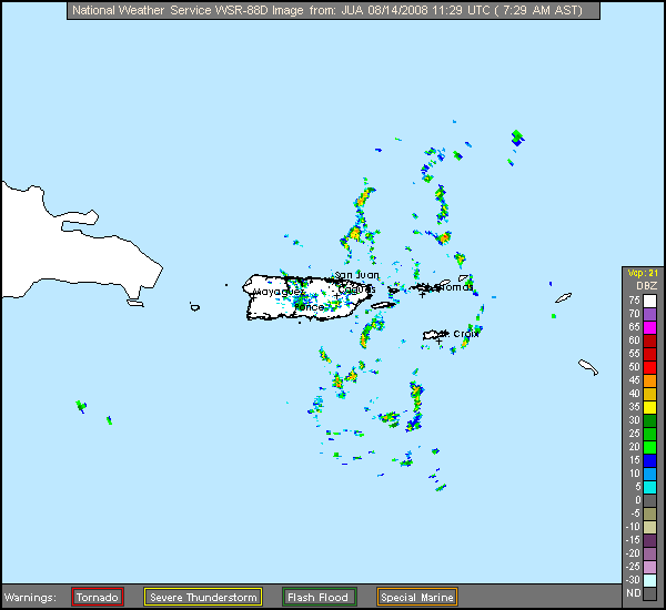
Thanks, Luis. Was going to post that, but got sidetracked. I know why those of us who live here and look at French radar every day can't get it to work... it's overloaded by being LIVE POSTED on the soon-2-be-1000-page thread about 92L. That makes it RELOAD for every person who brings up the thread page. (Sometimes good things are mixed blessing.)
Same thing for San Juan radar. If we who depend on it (because there is NO OTHER radar, not like in U.S., where there are many) want it available, we should discourage it being loaded "live" into posts. Let folks put a link, or take a snapshot and put in on imageshack.
Same thing for San Juan radar. If we who depend on it (because there is NO OTHER radar, not like in U.S., where there are many) want it available, we should discourage it being loaded "live" into posts. Let folks put a link, or take a snapshot and put in on imageshack.
0 likes
-
MiamiensisWx
Re: 92L NE Caribbean / Special local Statement Posted
bvigal wrote:Thanks, Luis. Was going to post that, but got sidetracked. I know why those of us who live here and look at French radar every day can't get it to work... it's overloaded by being LIVE POSTED on the soon-2-be-1000-page thread about 92L. That makes it RELOAD for every person who brings up the thread page. (Sometimes good things are mixed blessing.)
Same thing for San Juan radar. If we who depend on it (because there is NO OTHER radar, not like in U.S., where there are many) want it available, we should discourage it being loaded "live" into posts. Let folks put a link, or take a snapshot and put in on imageshack.
I always utilize links in my posts for satellite/radar data. I would STRONGLY encourage others to take heed now as well.
0 likes
Who is online
Users browsing this forum: No registered users and 108 guests