

Here we go.
BEGIN
NHC
invest_al932008.invest
FSTDA
R
U
040
010
0000
200808111251
NONE
NOTIFY=ATRP
END
INVEST, AL, L, , , , , 93, 2008, DB, O, 2008081112, 9999999999, , , , , , METWATCH, , AL932008
AL, 93, 2008081012, , BEST, 0, 103N, 232W, 20, 1009, DB, 0, , 0, 0, 0, 0,
AL, 93, 2008081018, , BEST, 0, 104N, 246W, 20, 1009, DB, 0, , 0, 0, 0, 0,
AL, 93, 2008081100, , BEST, 0, 105N, 260W, 25, 1009, DB, 0, , 0, 0, 0, 0,
AL, 93, 2008081106, , BEST, 0, 106N, 274W, 25, 1009, DB, 0, , 0, 0, 0, 0,
AL, 93, 2008081112, , BEST, 0, 108N, 288W, 25, 1008, DB, 34, NEQ, 0, 0, 0, 0, 1011, 180, 35, 0, 0, L, 0, , 0, 0, INVEST, D,
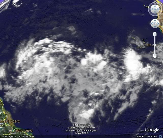
Ex Invest 93L in Central Atlantic
Moderator: S2k Moderators

-
Hyperstorm

- Category 5

- Posts: 1500
- Joined: Sun Sep 07, 2003 3:48 am
- Location: Ocala, FL
Re: East Atlantic: Invest 93L
Ha, I was just writing a topic about this system showing impressive organization and should be declared an invest at anytime when the original topic showed as locked, so couldn't write it.
Anyway, I was writing that it looks like the GFS was right all along as it is improving in organization markedly when compared to yesterday. The system in the front remained a wave (and looks to do that) as the models showed. Impressive how these models can sometimes predict with such accuracy.
I am confident this system will be developing into a tropical depression by tomorrow at the LATEST (It could surprise us with a classification as early as 5-11pm today.) per the very impressive structure and convection. It has that classic look of a Cape Verde developer.
The northern islands DO need to watch this one VERY carefully as it could be, IMO, the biggest threat since Hurricane Georges in 1998 for that area...
0 likes


-
Stratosphere747
- Category 5
- Posts: 3772
- Joined: Thu Sep 11, 2003 8:34 pm
- Location: Surfside Beach/Freeport Tx
- Contact:
-
Stratosphere747
- Category 5
- Posts: 3772
- Joined: Thu Sep 11, 2003 8:34 pm
- Location: Surfside Beach/Freeport Tx
- Contact:
Re:
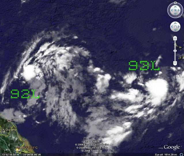
HURAKAN wrote:Disorganized 92L gets 1.0 while much better organized 93L gets TOO WEAK. In what kind of world are we living!!!!
Both are estimated at 'TOO WEAK.'
0 likes

Re:
HURAKAN wrote:Disorganized 92L gets 1.0 while much better organized 93L gets TOO WEAK. In what kind of world are we living!!!!
Persistance counts in the calculation. Since 93L has just been picked up it will need a little more time before the numbers go up. However, it does look much better than 92 does at this point.
MW
0 likes

 you can expect the unexpectable... no?
-
alan1961

- Category 2

- Posts: 767
- Joined: Mon Mar 20, 2006 11:58 am
- Location: Derby, Derbyshire, England
- Contact:
Re: East Atlantic: Invest 93L
Hmm..interesting last paragraph on accuweathers atlantic basin update..a tropical cyclone that intensifies and tracks towards the US east coast into the latter of next week..(93L)
http://hurricane.accuweather.com/hurric ... n=atlantic
http://hurricane.accuweather.com/hurric ... n=atlantic
0 likes
Re: East Atlantic: Invest 93L
This one has a better southern feed but the intensity of conditions in the area is unimpressive.
0 likes

>>Perhaps this is the one that will form. Looks alot better than 92L ever did.
What does this even mean? 92L is fine for what it is - a wave with some low pressure/rotation. It's around 50W. It's probably not going to do much (if ever) until it's after 70W. It is innocuous at the present time, but I don't expect that to be the case forever. You already know that you're not going to see Category 5 storms rolling off of Africa and crossing the entire Atlantic Basin as mature storms. You start with something and watch the evolutionary process.
Only because it's a week or so out, for kicks and giggles I'm going to go on the record in saying that 92L is an eventual Gulf Problem which probably won't be as strong in the end game as what 93L appears to be (potentially).
In my opinion, 93L is, in the words of the DK's, "We've Got A Bigger Problem Now." IMHO, whatever the models, pros or amateurs are saying, look for a more substantial storm than what we see with 92L. If this pattern spawns 2 or 3 systems in a mid-August run, look for the second system, again 93L, to take a silghtly more northerly path than whatever 92L does. Look for it also to get much stronger and become, perhaps, the biggest threat of the pre-peak of 2008 Hurricane Season.
*** DISCLAIMER ***
This post is the opinion of the poster who has posted it and that poster only. Do not rely on the contents, but if you're smart, you will consider them.
Steve
0 likes
Re: East Atlantic: Invest 93L
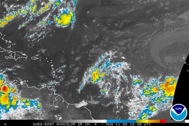
The Atlantic is slowly phasing between high season favorability and the weak conditions up to now. I think it just lapsed back into unfavorability but that will change soon.
0 likes
Re:
Steve wrote:>>Perhaps this is the one that will form. Looks alot better than 92L ever did.
What does this even mean? 92L is fine for what it is - a wave with some low pressure/rotation. It's around 50W. It's probably not going to do much (if ever) until it's after 70W. It is innocuous at the present time, but I don't expect that to be the case forever. You already know that you're not going to see Category 5 storms rolling off of Africa and crossing the entire Atlantic Basin as mature storms. You start with something and watch the evolutionary process.
Only because it's a week or so out, for kicks and giggles I'm going to go on the record in saying that 92L is an eventual Gulf Problem which probably won't be as strong in the end game as what 93L appears to be (potentially).
In my opinion, 93L is, in the words of the DK's, "We've Got A Bigger Problem Now." IMHO, whatever the models, pros or amateurs are saying, look for a more substantial storm than what we see with 92L. If this pattern spawns 2 or 3 systems in a mid-August run, look for the second system, again 93L, to take a silghtly more northerly path than whatever 92L does. Look for it also to get much stronger and become, perhaps, the biggest threat of the pre-peak of 2008 Hurricane Season.
*** DISCLAIMER ***
This post is the opinion of the poster who has posted it and that poster only. Do not rely on the contents, but if you're smart, you will consider them.
Steve
Great post Steve, and a point hopefully well taken.
The concern about 92 is not so much that it isn’t developing right away, but that it could become a seed for some trouble toward the end of the week.
The bad thing about the 2005 season is we saw this happen a lot. Katrina was a former TD, sheared and weak all across the Atlantic and then…POOF…it went to town just east of Florida.
Rita had a similar fate.
Sure we have had seasons like 2004 where something like Frances develops way east then trucks across the Atlantic…and it may happen sometime this season. For me, I would take eastern Atlantic development in a second over this close in late development we saw a few years ago. More chances to turn the big boys out to sea…these little ones tend to sneek across.
As for 93…I think people put a little too much faith in whatever the last model solution was. This one, ultimately, could be the bigger of the two.
MW
0 likes

You need to gator. There is sound methodology behind what Derek and 57 put out there for consumption. And I'm not going to do an American Rebel and put out some wacky prediction of a Cat 5 slamming the MS Gulf Coast or whatever (fwiw, one of my target areas this year with all due apologies to those of you who call that home). Still, these both have potential which is why they have the attention of the NRL and the TPC.
--------------------------
Mike,
Good to see you. You were one of the most important posters in 2005 IMHO. While everyone else was looking to be the first to ring the death knell on storms, you recognized real threats. Obviously they're not all going to pan out, but they need to be recognized. That's why this forum exists. While John Q. Public is watching local television or TWC and seeing a tropical update, other people are taking a hard look at all the possibilities. You're easily Top 10 [tm] on this site, and I look forward to your posts as we head more toward the heart of the season.
Steve
0 likes
Who is online
Users browsing this forum: No registered users and 107 guests