Typhoon Sinlaku in all its fury:
http://www.youtube.com/watch?v=2Ny_gFPn2L0
WPAC SINLAKU: Severe Tropical Storm - Discussion
Moderator: S2k Moderators
-
Typhoon Hunter
- WesternPacificWeather.com

- Posts: 1215
- Age: 40
- Joined: Wed Oct 11, 2006 11:37 am
- Location: Hong Kong
- Contact:


WTPQ20 RJTD 150600
RSMC TROPICAL CYCLONE ADVISORY
NAME STS 0813 SINLAKU (0813)
ANALYSIS
PSTN 150600UTC 26.5N 121.7E FAIR
MOVE ENE 06KT
PRES 980HPA
MXWD 060KT
GUST 085KT
50KT 60NM
30KT 180NM SOUTHEAST 150NM NORTHWEST
FORECAST
24HF 160600UTC 27.2N 124.4E 85NM 70%
MOVE ENE 06KT
PRES 975HPA
MXWD 065KT
GUST 095KT
48HF 170600UTC 28.1N 126.6E 160NM 70%
MOVE ENE SLOWLY
PRES 970HPA
MXWD 070KT
GUST 100KT
72HF 180600UTC 30.4N 129.6E 220NM 70%
MOVE NE 09KT
PRES 965HPA
MXWD 075KT
GUST 105KT =
0 likes
-
Harry Cane

- Tropical Low

- Posts: 33
- Joined: Tue Aug 21, 2007 11:23 pm
- Location: Asia
- Contact:
WTPQ20 RJTD 151200
RSMC TROPICAL CYCLONE ADVISORY
NAME STS 0813 SINLAKU (0813)
ANALYSIS
PSTN 151200UTC 26.9N 122.4E FAIR
MOVE ENE 07KT
PRES 980HPA
MXWD 060KT
GUST 085KT
50KT 60NM
30KT 180NM SOUTHEAST 150NM NORTHWEST
FORECAST
24HF 161200UTC 27.3N 125.2E 85NM 70%
MOVE E 06KT
PRES 975HPA
MXWD 065KT
GUST 095KT
48HF 171200UTC 28.7N 126.8E 160NM 70%
MOVE NE SLOWLY
PRES 965HPA
MXWD 075KT
GUST 105KT
72HF 181200UTC 30.6N 129.5E 220NM 70%
MOVE NE 08KT
PRES 955HPA
MXWD 080KT
GUST 115KT =
0 likes


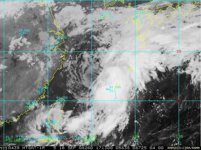
JMA has downgraded to TS but still expects re-intensification into a typhoon.
WTPQ20 RJTD 160000
RSMC TROPICAL CYCLONE ADVISORY
NAME TS 0813 SINLAKU (0813) DOWNGRADED FROM STS
ANALYSIS
PSTN 160000UTC 26.7N 123.5E FAIR
MOVE E 06KT
PRES 990HPA
MXWD 045KT
GUST 065KT
30KT 150NM SOUTHEAST 90NM NORTHWEST
FORECAST
24HF 170000UTC 27.1N 125.9E 85NM 70%
MOVE E SLOWLY
PRES 980HPA
MXWD 055KT
GUST 080KT
48HF 180000UTC 28.6N 127.4E 160NM 70%
MOVE NE SLOWLY
PRES 970HPA
MXWD 065KT
GUST 095KT
72HF 190000UTC 31.0N 130.3E 220NM 70%
MOVE NE 09KT
PRES 970HPA
MXWD 065KT
GUST 095KT =
0 likes
-
O Town
- S2K Supporter

- Posts: 5203
- Age: 50
- Joined: Wed Sep 07, 2005 9:37 pm
- Location: Orlando, Florida 28°35'35"N 81°22'55"W
Re: WPAC SINLAKU: Severe Tropical Storm - Discussion
Yikes!!!!! That was crazy footage, I found myself on the edge of my seat when you were trying to get a wind reading with that anemometer, thinking you were going to take off. What really surprised me about that footage was the people driving around in it, and also the lights stayed on that entire time, amazing.
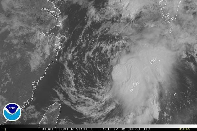
Looking at the track of Sinlaku it looks like another storm tip toed around the coast, look how he outlined Taiwan.
Amazing looking storm at its height.
0 likes
New rainfall totals from 11/16z to 16/00z:
*12日0時至16日8時出現較大累積雨量如下:台中縣雪嶺1608毫米、嘉義縣阿里山1462毫米、苗栗縣泰安1335毫米、南投縣阿眉1277毫米、新竹縣鳥嘴山1168毫米、台北市擎天1115毫米、宜蘭縣太平山1070毫米、高雄縣御油山1009毫米、桃園縣拉拉山995毫米、台北縣福山980毫米、台南縣關山707毫米。
Peak rainfall total in the 104 hours:
Taichung County Xueling station: 1608 mm = 63.3 inches of storm total rainfall
Chiayi County Alishan Township: 1462 mm = 57.6 inches
Miaoli County Tai-an Township: 1335 mm = 52.6 inches
0 likes
WTPQ20 RJTD 161200
RSMC TROPICAL CYCLONE ADVISORY
NAME TS 0813 SINLAKU (0813)
ANALYSIS
PSTN 161200UTC 27.2N 124.8E FAIR
MOVE E 09KT
PRES 994HPA
MXWD 040KT
GUST 060KT
30KT 150NM SOUTHEAST 90NM NORTHWEST
FORECAST
24HF 171200UTC 28.4N 127.0E 85NM 70%
MOVE ENE 06KT
PRES 985HPA
MXWD 050KT
GUST 070KT
48HF 181200UTC 30.7N 129.4E 160NM 70%
MOVE NE 08KT
PRES 980HPA
MXWD 055KT
GUST 080KT
72HF 191200UTC 32.9N 133.0E 220NM 70%
MOVE NE 09KT
PRES 994HPA
MXWD 045KT
GUST 065KT =
I cannot comprehend how a T2.0, partially-exposed system can still be a 40 kt TS.
0 likes
WTPQ20 RJTD 170300
RSMC TROPICAL CYCLONE ADVISORY
NAME TS 0813 SINLAKU (0813)
ANALYSIS
PSTN 170300UTC 27.6N 126.1E FAIR
MOVE NE SLOWLY
PRES 992HPA
MXWD 040KT
GUST 060KT
30KT 150NM EAST 90NM WEST
FORECAST
24HF 180300UTC 29.9N 128.6E 85NM 70%
MOVE NE 08KT
PRES 980HPA
MXWD 055KT
GUST 080KT
45HF 190000UTC 32.1N 131.7E 160NM 70%
MOVE NE 10KT
PRES 990HPA
MXWD 045KT
GUST 065KT
69HF 200000UTC 34.5N 137.5E 250NM 70%
MOVE ENE 14KT
PRES 998HPA
MXWD 035KT
GUST 050KT =
0 likes

-
HURAKAN

- Professional-Met

- Posts: 46086
- Age: 37
- Joined: Thu May 20, 2004 4:34 pm
- Location: Key West, FL
- Contact:
Re: WPAC SINLAKU: Tropical Storm - Discussion (storm total 63 in
Death toll from Typhoon Sinlaku climbs to 12
Central News Agency
2008-09-17 04:47 PM
The number of people confirmed dead from Typhoon Sinlaku has risen to 12, the Central Emergency Operation Center said Wednesday.
The latest fatality added to the list is a woman from Puli in the central county of Nantou, who was reported missing after falling into a river Sunday. Her body was recovered late Tuesday.
The number also includes the seven people who were buried by landslides near the Fongciou Tunnel in Nantou Monday. The bodies of all the victims were dug out by Tuesday.
On Wednesday, three persons are still listed as unaccounted for in the county. The latest potential casualty is a hotel worker who was buried by mudslides in the hot springs area of Lushan on Monday.
In Taichung County, rescue workers are still searching for the five drivers and passengers of two vehicles that plunged into the Dajia River when part of the Houfeng Bridge collapsed Sunday. The body of the other victim, who also fell into the river together with his car, was recovered Monday.
Meanwhile, two residents of Changhua County are still listed as missing.
0 likes
It's now an STS again.
WTPQ20 RJTD 171200
RSMC TROPICAL CYCLONE ADVISORY
NAME STS 0813 SINLAKU (0813) UPGRADED FROM TS
ANALYSIS
PSTN 171200UTC 28.8N 127.8E FAIR
MOVE ENE 12KT
PRES 985HPA
MXWD 050KT
GUST 070KT
30KT 150NM EAST 90NM WEST
FORECAST
24HF 181200UTC 30.7N 130.3E 85NM 70%
MOVE NE 08KT
PRES 980HPA
MXWD 055KT
GUST 080KT
48HF 191200UTC 33.2N 133.9E 160NM 70%
MOVE NE 10KT
PRES 992HPA
MXWD 045KT
GUST 065KT
72HF 201200UTC 35.5N 140.8E 250NM 70% EXTRATROPICAL LOW =
0 likes

Who is online
Users browsing this forum: No registered users and 34 guests