Hello!
After the madness of Taiwan last week where my trip to take part in a documentary was interrupted by typhoon Sinlaku and all its fury, I'm in Hong Kong kicking back with my girlfriend. This has been planned for weeks. It now looks like for the second time in a fortnight I'm going to have a major typhoon crashing in on me!
Typhoon Hagiput has been cranking up north of the Philippines and is due to make a close pass of Hong Kong tomorrow night or Wednesday morning. Given the acute angle of attack on the Chinese coast any jog to the north will take this much closer to Hong Kong than currently forecast.
I will be heading up the highest hills exposed to the NE and south (thinking Victoria Peak) where I should be able to experience some insane winds. Even during TSs which pass close by the peaks of Hong Kong can experience some INSANE winds speeds. If this jogs NW and makes a direct hit then it will of course be the most high impact storm on Hong Kong in years! Going to be a tense 24 hours!
WPAC HAGUPIT (PAGASA: Nina): Typhoon - Discussion
Moderator: S2k Moderators
-
Typhoon Hunter
- WesternPacificWeather.com

- Posts: 1215
- Age: 40
- Joined: Wed Oct 11, 2006 11:37 am
- Location: Hong Kong
- Contact:

WTPQ21 RJTD 230000
RSMC TROPICAL CYCLONE ADVISORY
NAME TY 0814 HAGUPIT (0814)
ANALYSIS
PSTN 230000UTC 20.2N 117.3E GOOD
MOVE W 17KT
PRES 935HPA
MXWD 090KT
GUST 130KT
50KT 110NM
30KT 240NM WEST 210NM EAST
FORECAST
24HF 240000UTC 21.1N 112.2E 75NM 70%
MOVE W 12KT
PRES 945HPA
MXWD 085KT
GUST 120KT
48HF 250000UTC 22.2N 108.1E 140NM 70%
MOVE WNW 11KT
PRES 994HPA
MXWD 045KT
GUST 065KT
72HF 260000UTC 22.7N 105.6E 160NM 70% TROPICAL DEPRESSION =
0 likes

Bulletin issued at 10:46 HKT 23/Sep/2008
Tropical Cyclone Bulletin
Here is the latest Tropical Cyclone Bulletin issued by the
Hong Kong Observatory.
The Strong Wind Signal, No. 3 is in force.
This means that winds with mean speeds of 41 to 62
kilometres per hour are expected.
At 11 a.m., Typhoon Hagupit was estimated to be about 360
kilometres southeast of Hong Kong (near 20.2 degrees north
116.8 degrees east) and is forecast to move west or
west-northwest at about 28 kilometres per hour edging
closer to the south China coast.
According to Hagupits' present track, the Observatory will
consider the need for the No.8 Gale or Storm Signal around
dusk today.
0 likes


Re: WPAC HAGUPIT (PAGASA: Nina): Typhoon - Discussion
Track local conditions in Hong Kong...as of 6:00 P.M. local time (Hong Kong is 12 hours ahead of EDT), winds gusting to 35mph...55 km/hr.
http://www.wunderground.com/weatherstation/WXDailyHistory.asp?ID=IVICTORI77
http://www.wunderground.com/weatherstation/WXDailyHistory.asp?ID=IVICTORI77
Last edited by jinftl on Tue Sep 23, 2008 5:26 am, edited 1 time in total.
0 likes
-
Typhoon Hunter
- WesternPacificWeather.com
- Posts: 1215
- Age: 40
- Joined: Wed Oct 11, 2006 11:37 am
- Location: Hong Kong
- Contact:
Re: WPAC HAGUPIT (PAGASA: Nina): Typhoon - Discussion
Up at Victoria Peak and it's windy!
Max gust recorded so far over Hong Kong is 134km/h at Tate's Cairn. Signal 8 has just been hoisted and Hong Kong will be shut down for the night! We're going to head to Stanley which will face off the South China Sea when winds swing round to the ESE.
Max gust recorded so far over Hong Kong is 134km/h at Tate's Cairn. Signal 8 has just been hoisted and Hong Kong will be shut down for the night! We're going to head to Stanley which will face off the South China Sea when winds swing round to the ESE.
0 likes


WTPQ21 RJTD 231200
RSMC TROPICAL CYCLONE ADVISORY
NAME TY 0814 HAGUPIT (0814)
ANALYSIS
PSTN 231200UTC 20.6N 114.2E GOOD
MOVE W 13KT
PRES 935HPA
MXWD 090KT
GUST 130KT
50KT 110NM
30KT 210NM
FORECAST
24HF 241200UTC 22.0N 108.3E 75NM 70%
MOVE WNW 14KT
PRES 980HPA
MXWD 050KT
GUST 070KT
48HF 251200UTC 22.9N 104.6E 110NM 70% TROPICAL DEPRESSION =
0 likes

-
Category 5

- Category 5

- Posts: 10074
- Age: 34
- Joined: Sun Feb 11, 2007 10:00 pm
- Location: New Brunswick, NJ
- Contact:
Re: WPAC HAGUPIT (PAGASA: Nina): Typhoon - Discussion
Sustained at 50mph gusting to 75mph in Hong Kong via weather underground.
Very lucky this is not making landfall. I still would expect some high rise windows to blow out.
Very lucky this is not making landfall. I still would expect some high rise windows to blow out.
0 likes

WTPQ21 RJTD 231500
RSMC TROPICAL CYCLONE ADVISORY
NAME TY 0814 HAGUPIT (0814)
ANALYSIS
PSTN 231500UTC 20.8N 113.3E GOOD
MOVE W 12KT
PRES 935HPA
MXWD 090KT
GUST 130KT
50KT 110NM
30KT 210NM
FORECAST
24HF 241500UTC 22.1N 107.8E 75NM 70%
MOVE WNW 13KT
PRES 980HPA
MXWD 050KT
GUST 070KT
45HF 251200UTC 22.9N 104.6E 110NM 70% TROPICAL DEPRESSION =
Bulletin issued at 23:46 HKT 23/Sep/2008
Tropical Cyclone Bulletin
Here is the latest Tropical Cyclone Bulletin issued by the
Hong Kong Observatory.
The No. 8 Northeast Gale or Storm Signal is in force.
This means that winds with mean speeds of 63 kilometres per
hour or more are expected from the northeast quarter.
At midnight, Typhoon Hagupit was centred about 200
kilometres south-southwest of Hong Kong (near 20.8 degrees
north 113.1 degrees east) and is forecast to move west or
west-northwest at about 28 kilometres per hour heading
towards the western coast of Guangdong.
Hagupit is skirting past to the southwest of Hong Kong. It
will remain at a distance of about 200 kilometres from Hong
Kong in the next few hours. The No.8 Gale or Storm Signal
will be in force throughout the overnight period.
Owing to the combined effect of Hagupit and high tide,
tides at many places are currently running more than 1
metre above normal. The tide is higher than normal by
about 1.6 metres at Tai Po Kau, and about 1.3 metres at
Quarry Bay. Flooding is expected overnight in low lying
areas.
In the past hour, the maximum sustained wind speeds
recorded at Chek Lap Kok and Cheung Chau were 80 and 112
kilometres per hour respectively.
0 likes
-
zaqxsw75050

- Tropical Storm

- Posts: 178
- Joined: Thu Mar 06, 2008 4:21 pm
- Location: Hong Kong
Re: WPAC HAGUPIT (PAGASA: Nina): Typhoon - Discussion
Good thing it didn't make a direct hit on Hong Kong. If so it would be the worst storm in many years.
0 likes
Bulletin issued at 00:45 HKT 24/Sep/2008
Tropical Cyclone Bulletin
Here is the latest Tropical Cyclone Bulletin issued by the
Hong Kong Observatory.
The No. 8 Southeast Gale or Storm Signal is in force.
This means that winds with mean speeds of 63 kilometres per
hour or more are expected from the southeast quarter.
At 1 a.m., Typhoon Hagupit was centred about 200 kilometres
southwest of Hong Kong (near 20.9 degrees north 112.9
degrees east) and is forecast to move west or
west-northwest at about 28 kilometres per hour heading
towards the western coast of Guangdong.
Hagupit is skirting past to the southwest of Hong Kong.
Winds over Hong Kong are expected to gradually turn to east
to southeast. Some places originally sheltered will become
exposed to the winds. According to the present track, the
No.8 Gale or Storm Signal will stay in force till at least
6 a.m. today.
Owing to the combined effect of Hagupit and high tide,
tides at many places are currently running more than 1
metre above normal. The tide is higher than normal by
about 1.6 metres at Tai Po Kau, and about 1.3 metres at
Quarry Bay. Flooding is expected overnight in low lying
areas.
In the past hour, the maximum sustained wind speeds
recorded at Chek Lap Kok and Cheung Chau were 73 and 102
kilometres per hour respectively.
0 likes

Re: WPAC HAGUPIT (PAGASA: Nina): Typhoon - Discussion
Category 5 wrote:Sustained at 50mph gusting to 75mph in Hong Kong via weather underground.
Very lucky this is not making landfall. I still would expect some high rise windows to blow out.
You mean landfall in Hong Kong since this is certainly going to make landfall somewhere along the coast.
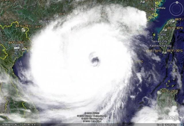
The cloud tops surrounding most of that large eye are impressive. I don't see that many large TC's with that type of sig.
0 likes
-
CrazyC83
- Professional-Met

- Posts: 33393
- Joined: Tue Mar 07, 2006 11:57 pm
- Location: Deep South, for the first time!
UW - CIMSS
ADVANCED DVORAK TECHNIQUE
ADT-Version 7.2.3
Tropical Cyclone Intensity Algorithm
----- Current Analysis -----
Date : 23 SEP 2008 Time : 171500 UTC
Lat : 21:11:13 N Lon : 112:28:10 E
CI# /Pressure/ Vmax
6.9 / 902.1mb/137.4kt
Final T# Adj T# Raw T#
(3hr avg)
6.9 7.2 7.2
Latitude bias adjustment to MSLP : +0.9mb
Estimated radius of max. wind based on IR : 38 km
Center Temp : +7.2C Cloud Region Temp : -77.9C
Scene Type : EYE
Positioning Method : RING/SPIRAL COMBINATION
Ocean Basin : WEST PACIFIC
Dvorak CI > MSLP Conversion Used : PACIFIC
Tno/CI Rules : Constraint Limits : NO LIMIT
Weakening Flag : OFF
Rapid Dissipation Flag : OFF
0 likes
Who is online
Users browsing this forum: No registered users and 66 guests