WPAC JANGMI: Tropical Storm - Discussion

Moderator: S2k Moderators

Message
Author
User avatar
HURAKAN
Professional-Met
Professional-Met
Posts: 46086
Age: 37
Joined: Thu May 20, 2004 4:34 pm
Location: Key West, FL
Contact:

#81 Postby HURAKAN » Fri Sep 26, 2008 9:50 pm

Image
0 likes   

User avatar
HURAKAN
Professional-Met
Professional-Met
Posts: 46086
Age: 37
Joined: Thu May 20, 2004 4:34 pm
Location: Key West, FL
Contact:

#82 Postby HURAKAN » Fri Sep 26, 2008 9:57 pm

0 likes   

User avatar
Chacor
Category 5
Category 5
Posts: 10229
Joined: Mon Oct 02, 2006 10:43 pm
Location: Singapore

#83 Postby Chacor » Fri Sep 26, 2008 11:41 pm

27/0230 UTC 20.1N 126.0E T7.0/7.0 JANGMI -- West Pacific Ocean
0 likes   

Ed Mahmoud

Re:

#84 Postby Ed Mahmoud » Fri Sep 26, 2008 11:43 pm

Chacor wrote:27/0230 UTC 20.1N 126.0E T7.0/7.0 JANGMI -- West Pacific Ocean


Taiwan just isn't catching any breaks this year...
0 likes   

CrazyC83
Professional-Met
Professional-Met
Posts: 33393
Joined: Tue Mar 07, 2006 11:57 pm
Location: Deep South, for the first time!

Re: Re:

#85 Postby CrazyC83 » Fri Sep 26, 2008 11:47 pm

Ed Mahmoud wrote:
Chacor wrote:27/0230 UTC 20.1N 126.0E T7.0/7.0 JANGMI -- West Pacific Ocean


Taiwan just isn't catching any breaks this year...


I wouldn't be surprised to see Recon find a storm as strong as 150 kt given its structure and comparisons with past Atlantic storms.
0 likes   

Ed Mahmoud

Re: WPAC JANGMI - Typhoon: Discussion

#86 Postby Ed Mahmoud » Fri Sep 26, 2008 11:52 pm

Wow

Image
0 likes   

User avatar
Chacor
Category 5
Category 5
Posts: 10229
Joined: Mon Oct 02, 2006 10:43 pm
Location: Singapore

#87 Postby Chacor » Fri Sep 26, 2008 11:53 pm

Image
0 likes   

Ed Mahmoud

Re: WPAC JANGMI - Typhoon: Discussion

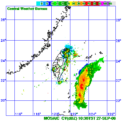
#88 Postby Ed Mahmoud » Sat Sep 27, 2008 12:33 am

You can see the stadium effect...

Image
0 likes   

User avatar
Chacor
Category 5
Category 5
Posts: 10229
Joined: Mon Oct 02, 2006 10:43 pm
Location: Singapore

#89 Postby Chacor » Sat Sep 27, 2008 1:23 am

Very warm eye.

Image
0 likes   

RL3AO
Moderator-Pro Met
Moderator-Pro Met
Posts: 16308
Joined: Thu Jun 14, 2007 10:03 pm
Location: NC

#90 Postby RL3AO » Sat Sep 27, 2008 1:31 am

No disrespect to Dean or Felix, but this is the best looking TC since Monica IMO.
0 likes   

User avatar
Chacor
Category 5
Category 5
Posts: 10229
Joined: Mon Oct 02, 2006 10:43 pm
Location: Singapore

#91 Postby Chacor » Sat Sep 27, 2008 1:51 am

WTPQ20 RJTD 270600
RSMC TROPICAL CYCLONE ADVISORY
NAME TY 0815 JANGMI (0815)
ANALYSIS
PSTN 270600UTC 20.7N 125.6E GOOD
MOVE NW 13KT
PRES 915HPA
MXWD 105KT
GUST 150KT
50KT 120NM
30KT 240NM
FORECAST
24HF 280600UTC 23.9N 121.9E 75NM 70%
MOVE NW 12KT
PRES 925HPA
MXWD 100KT
GUST 140KT
48HF 290600UTC 25.8N 120.7E 110NM 70%
MOVE NNW SLOWLY
PRES 970HPA
MXWD 065KT
GUST 095KT
72HF 300600UTC 28.0N 122.6E 220NM 70%
MOVE NE 07KT
PRES 985HPA
MXWD 050KT
GUST 070KT =
0 likes   

User avatar
bahamaswx
Category 5
Category 5
Posts: 1542
Joined: Sat Sep 13, 2003 1:11 am
Location: Georgetown, Bahamas

#92 Postby bahamaswx » Sat Sep 27, 2008 2:26 am

I don't really follow the WPAC, but when did they decide to start flying recon in the WPAC again?
0 likes   

User avatar
Chacor
Category 5
Category 5
Posts: 10229
Joined: Mon Oct 02, 2006 10:43 pm
Location: Singapore

Re:

#93 Postby Chacor » Sat Sep 27, 2008 2:29 am

bahamaswx wrote:I don't really follow the WPAC, but when did they decide to start flying recon in the WPAC again?


The ongoing flight is the last scheduled one. It's been part of a two-month research project.
0 likes   

Typhoon Hunter
WesternPacificWeather.com
Posts: 1215
Age: 40
Joined: Wed Oct 11, 2006 11:37 am
Location: Hong Kong
Contact:

Re: WPAC JANGMI - Typhoon: Discussion

#94 Postby Typhoon Hunter » Sat Sep 27, 2008 2:47 am

I'm in Kaosiung en route to Hualien. I know all the right places to shelter in town should this make a direct hit. More updates to come here and on my website.
0 likes   

User avatar
Matt-hurricanewatcher
Category 5
Category 5
Posts: 11649
Age: 38
Joined: Fri Nov 26, 2004 11:09 pm
Location: Portland,OR
Contact:

Re: WPAC JANGMI - Typhoon: Discussion

#95 Postby Matt-hurricanewatcher » Sat Sep 27, 2008 3:30 am

This is one of the most flawless cyclones I've seen.

Strength thinking

Winds 150 knots
Pressure 897 millibars
0 likes   

User avatar
Chacor
Category 5
Category 5
Posts: 10229
Joined: Mon Oct 02, 2006 10:43 pm
Location: Singapore

#96 Postby Chacor » Sat Sep 27, 2008 3:36 am

159 kts found in NW quad by recon.
0 likes   

User avatar
bahamaswx
Category 5
Category 5
Posts: 1542
Joined: Sat Sep 13, 2003 1:11 am
Location: Georgetown, Bahamas

Re:

#97 Postby bahamaswx » Sat Sep 27, 2008 3:44 am

Chacor wrote:159 kts found in NW quad by recon.


Now is that a 10min average, or 1min?
0 likes   

User avatar
P.K.
Professional-Met
Professional-Met
Posts: 5149
Joined: Thu Sep 23, 2004 5:57 pm
Location: Watford, England
Contact:

Re: WPAC JANGMI - Typhoon: Discussion

#98 Postby P.K. » Sat Sep 27, 2008 3:45 am

That converts to 125kts at the surface using a ten minute average.
0 likes   

User avatar
Chacor
Category 5
Category 5
Posts: 10229
Joined: Mon Oct 02, 2006 10:43 pm
Location: Singapore

Re: Re:

#99 Postby Chacor » Sat Sep 27, 2008 3:47 am

bahamaswx wrote:
Chacor wrote:159 kts found in NW quad by recon.


Now is that a 10min average, or 1min?


That was a flight-level reading, not surface wind. Should've made it clear.
0 likes   

User avatar
wxmann_91
Category 5
Category 5
Posts: 8013
Age: 32
Joined: Fri Jul 15, 2005 2:49 pm
Location: Southern California
Contact:

#100 Postby wxmann_91 » Sat Sep 27, 2008 3:53 am

Microwave:

Image


One of the last visibles of the day

Image
0 likes   


Return to “2008”

Who is online

Users browsing this forum: No registered users and 49 guests