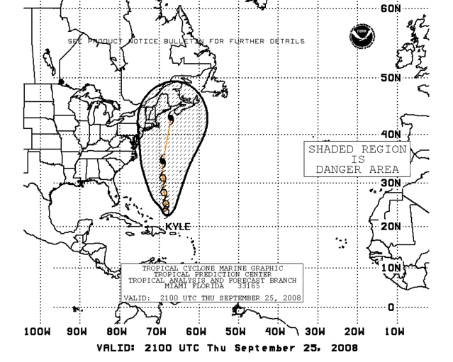
Best Track update at 00:00 UTC mantains 94L as Extratropical.
AL, 94, 2008092600, , BEST, 0, 334N, 782W, 55, 998, EX
ATL INVEST 94L: Discussion
Moderator: S2k Moderators
-
cycloneye

- Admin

- Posts: 139089
- Age: 67
- Joined: Thu Oct 10, 2002 10:54 am
- Location: San Juan, Puerto Rico
Re: ATL INVEST 94L: Discussion
0 likes
-
HURAKAN

- Professional-Met

- Posts: 46086
- Age: 37
- Joined: Thu May 20, 2004 4:34 pm
- Location: Key West, FL
- Contact:
Re: ATL INVEST 94L: Discussion
VORTEX DATA MESSAGE AL942008
A. 26/00:29:30Z
B. 33 deg 15 min N
078 deg 17 min W
C. 850 mb 1331 m
D. 51 kt
E. 352 deg 25 nm
F. 080 deg 58 kt
G. 352 deg 25 nm
H. 991 mb
I. 12 C / 1511 m
J. 19 C / 1525 m
K. 12 C / NA
L. NA
M. NA
N. 12345 / 8
O. 0.02 / 1 nm
P. AF303 03GGA LOW OB 09
MAX FL WIND 58 KT NE QUAD 23:32:50Z
19C at 1525 m?
0 likes
-
Matt-hurricanewatcher

- Category 5

- Posts: 11649
- Age: 38
- Joined: Fri Nov 26, 2004 11:09 pm
- Location: Portland,OR
- Contact:
Re: ATL INVEST 94L: Discussion
7c temperature difference, this is not just subtropical but full on tropical. I'm angry at what I'm seeing.
0 likes
-
CrazyC83
- Professional-Met
- Posts: 33393
- Joined: Tue Mar 07, 2006 11:57 pm
- Location: Deep South, for the first time!
http://moe.met.fsu.edu/cyclonephase/hwr ... 512/6.html
http://moe.met.fsu.edu/cyclonephase/gfd ... 518/2.html
Cyclone phase analysis.
http://moe.met.fsu.edu/cyclonephase/gfd ... 518/2.html
Cyclone phase analysis.
0 likes
-
CrazyC83
- Professional-Met
- Posts: 33393
- Joined: Tue Mar 07, 2006 11:57 pm
- Location: Deep South, for the first time!
Re: ATL INVEST 94L: Discussion
Matt-hurricanewatcher wrote:7c temperature difference, this is not just subtropical but full on tropical. I'm angry at what I'm seeing.
I agree, but given the circumstances it is not worth naming IMO.
0 likes
-
Matt-hurricanewatcher
- Category 5
- Posts: 11649
- Age: 38
- Joined: Fri Nov 26, 2004 11:09 pm
- Location: Portland,OR
- Contact:
Re: ATL INVEST 94L: Discussion
CrazyC83 wrote:Matt-hurricanewatcher wrote:7c temperature difference, this is not just subtropical but full on tropical. I'm angry at what I'm seeing.
I agree, but given the circumstances it is not worth naming IMO.
I think every system should be named or at least noted.
0 likes
-
Stormavoider
- Category 2

- Posts: 671
- Joined: Sat Jul 01, 2006 4:37 pm
- Location: Spring Hill Fl.

Re: ATL INVEST 94L: Discussion
Stormavoider wrote:Does this prove it is warm core?
We know it's warm core already. The problem is that still appears to be associated with a coastal warm front that has moved inland across the Carolinas, based on surface obs:
http://www.meteo.psu.edu/~gadomski/SFCSE/sfcloop.html
0 likes
-
HURAKAN
- Professional-Met
- Posts: 46086
- Age: 37
- Joined: Thu May 20, 2004 4:34 pm
- Location: Key West, FL
- Contact:
Re: ATL INVEST 94L: Discussion
CLKN7 - MARITIME-buoy
Friday Sep. 26 - 0:00 UTC
Air Temperature: 77°F
Dewpoint: 70°F
Wind: 25 mph
gusting to 28
Pressure: 1007.2 mb
41035 - MARITIME-buoy
Friday Sep. 26 - 0:50 UTC
Air Temperature: 76°F
Dewpoint: 71°F
Wind: E at 25 mph
gusting to 31
Pressure: 1005.1 mb
Wave Height: 8 ft
Sea Surface Temp: 75°F
41036 - MARITIME-buoy
Friday Sep. 26 - 0:50 UTC
Air Temperature: 78°F
Dewpoint: 71°F
Wind: ESE at 36 mph
gusting to 47
Pressure: 1004 mb
Wave Height: 15 ft
Sea Surface Temp: 78.1°F
41013 - MARITIME-buoy
Friday Sep. 26 - 0:50 UTC
Air Temperature: 75°F
Wind: SSE at 42 mph
gusting to 54
Pressure: 995.3 mb
Wave Height: 13 ft
Sea Surface Temp: 77.2°F
0 likes
-
Matt-hurricanewatcher
- Category 5
- Posts: 11649
- Age: 38
- Joined: Fri Nov 26, 2004 11:09 pm
- Location: Portland,OR
- Contact:
Re:
CrazyC83 wrote:Looks like the No-Name Storm is about to make landfall.
Sad
0 likes

Re: ATL INVEST 94L: Discussion
Funny, weather tonight in Myrtle Beach is much worse than it was a few weeks ago when Hannah blew through. I just hope my Dish Network signal stays strong for a few more hours.
0 likes
-
tolakram
- Admin
- Posts: 19165
- Age: 60
- Joined: Sun Aug 27, 2006 8:23 pm
- Location: Florence, KY (name is Mark)
Re: ATL INVEST 94L: Discussion
Wilmington:

Bald Head Island:
http://www.wunderground.com/weatherstat ... =KNCBALDH2

Sunset Beach:
http://www.wunderground.com/weatherstat ... =KNCSUNSE3

Bald Head Island:
http://www.wunderground.com/weatherstat ... =KNCBALDH2
Sunset Beach:
http://www.wunderground.com/weatherstat ... =KNCSUNSE3
0 likes

-
george_r_1961

- S2K Supporter

- Posts: 3171
- Age: 62
- Joined: Sat Oct 12, 2002 9:14 pm
- Location: Hampton, Virginia
Re: ATL INVEST 94L: Discussion
SCHawkFan wrote:Funny, weather tonight in Myrtle Beach is much worse than it was a few weeks ago when Hannah blew through. I just hope my Dish Network signal stays strong for a few more hours.
Ditto up here in VA. We have had heavy squalls rotating in off the ocean all day. Similar to what you would expect from an approaching tropical system.
And im not liking the looks of some of these cells. Some weak rotation evident and I wouldnt be surprised to see a tornado or two over SE VA overnight.
0 likes
-
HURAKAN
- Professional-Met
- Posts: 46086
- Age: 37
- Joined: Thu May 20, 2004 4:34 pm
- Location: Key West, FL
- Contact:
URNT12 KNHC 260225
VORTEX DATA MESSAGE AL942008
A. 26/02:15:00Z
B. 33 deg 17 min N
078 deg 35 min W
C. 850 mb 1351 m
D. 39 kt
E. 119 deg 37 nm
F. 194 deg 47 kt
G. 115 deg 23 nm
H. EXTRAP 993 mb
I. 14 C / 1521 m
J. 18 C / 1522 m
K. 13 C / NA
L. NA
M. NA
N. 12345 / 8
O. 0.02 / 1 nm
P. AF303 03GGA LOW OB 13
MAX FL WIND 58 KT NE QUAD 23:32:50Z
SLP EXTRAP FROM 850 MB
MAX FL TEMP 18 C 114 / 7 NM FROM FL CNTR
Once again, 18C at 1522 m.
0 likes
-
Ed Mahmoud
Re:
HURAKAN wrote:URNT12 KNHC 260225
VORTEX DATA MESSAGE AL942008
A. 26/02:15:00Z
B. 33 deg 17 min N
078 deg 35 min W
C. 850 mb 1351 m
D. 39 kt
E. 119 deg 37 nm
F. 194 deg 47 kt
G. 115 deg 23 nm
H. EXTRAP 993 mb
I. 14 C / 1521 m
J. 18 C / 1522 m
K. 13 C / NA
L. NA
M. NA
N. 12345 / 8
O. 0.02 / 1 nm
P. AF303 03GGA LOW OB 13
MAX FL WIND 58 KT NE QUAD 23:32:50Z
SLP EXTRAP FROM 850 MB
MAX FL TEMP 18 C 114 / 7 NM FROM FL CNTR
Once again, 18C at 1522 m.
Why bother when they already made up their mind that no evidence the airplane could find would change their minds.?
0 likes
Who is online
Users browsing this forum: No registered users and 110 guests