ATL INVEST 94L: Discussion

Moderator: S2k Moderators

Message
Author
User avatar
HURAKAN
Professional-Met
Professional-Met
Posts: 46086
Age: 37
Joined: Thu May 20, 2004 4:34 pm
Location: Key West, FL
Contact:

Re:

#341 Postby HURAKAN » Thu Sep 25, 2008 9:38 pm

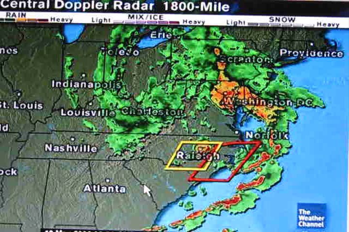
HURAKAN wrote:URNT12 KNHC 260225
VORTEX DATA MESSAGE AL942008
A. 26/02:15:00Z
B. 33 deg 17 min N
078 deg 35 min W
C. 850 mb 1351 m
D. 39 kt
E. 119 deg 37 nm
F. 194 deg 47 kt
G. 115 deg 23 nm
H. EXTRAP 993 mb
I. 14 C / 1521 m
J. 18 C / 1522 m
K. 13 C / NA

L. NA
M. NA
N. 12345 / 8
O. 0.02 / 1 nm
P. AF303 03GGA LOW OB 13
MAX FL WIND 58 KT NE QUAD 23:32:50Z
SLP EXTRAP FROM 850 MB
MAX FL TEMP 18 C 114 / 7 NM FROM FL CNTR

Once again, 18C at 1522 m.
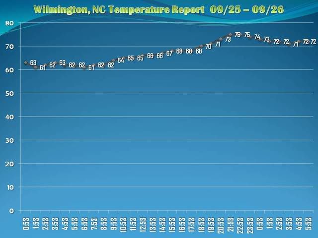

URNT12 KNHC 100125
VORTEX DATA MESSAGE
A. 10/01:07:50Z
B. 36 deg 04 min N
075 deg 34 min W
C. 850 mb 1491 m
D. NA kt
E. deg nm
F. 232 deg 042 kt
G. 160 deg 063 nm
H. 1008 mb
I. 18 C/ 1521 m
J. 19 C/ 1523 m
K. 18 C/ NA

L. NA
M. NA
N. 1345 / 8
O. 0.02 / 3 nm
P. AF305 0607A GABRIELLE OB 08
MAX FL WIND 42 KT SE QUAD 00:48:20 Z

94L: 18C at 1522 m.

Gabrielle: 19C at 1523 m.
0 likes   

CrazyC83
Professional-Met
Professional-Met
Posts: 33393
Joined: Tue Mar 07, 2006 11:57 pm
Location: Deep South, for the first time!

#342 Postby CrazyC83 » Thu Sep 25, 2008 9:39 pm

I think this calls for a poll to be created on the status of 94L. The options should be extratropical storm, subtropical storm, tropical storm.
0 likes   

CrazyC83
Professional-Met
Professional-Met
Posts: 33393
Joined: Tue Mar 07, 2006 11:57 pm
Location: Deep South, for the first time!

#343 Postby CrazyC83 » Thu Sep 25, 2008 9:40 pm

Current Weather/Wave Observations
Updated: 10:15 PM EDT on September 25, 2008
Air Temperature: 74° F / 24° C
Wind direction (W Dir): East (95 - 104 Degrees)
Wind Speed (W Spd): 45.0 kts (51.8 mph / 83.3 km/h)
Atmospheric Pressure (AP): 29.44 in / 997 hPa

http://www.wunderground.com/MAR/buoy/OCPN7.html
0 likes   

User avatar
Matt-hurricanewatcher
Category 5
Category 5
Posts: 11649
Age: 38
Joined: Fri Nov 26, 2004 11:09 pm
Location: Portland,OR
Contact:

Re: ATL INVEST 94L: Discussion

#344 Postby Matt-hurricanewatcher » Thu Sep 25, 2008 9:43 pm

Tropical storm...
1# Tight innercore
2# Well defined warm core
3# Well defined wind core

Maybe not the best on earth, but one at that. If this had another 12 hours it would form a CDO over its core.
0 likes   

seahawkjd
S2K Supporter
S2K Supporter
Posts: 632
Joined: Wed Sep 10, 2003 4:12 pm
Location: Morehead City, NC
Contact:

Re: ATL INVEST 94L: Discussion

#345 Postby seahawkjd » Thu Sep 25, 2008 9:43 pm

Over the past few hours we've had absolutely torrential rain bands come through, some tornado warnings, gusty winds. At one point my place was shaking and I couldn't see out the window. Nothing major, but pretty close to what hanah was like.
0 likes   

User avatar
bahamaswx
Category 5
Category 5
Posts: 1542
Joined: Sat Sep 13, 2003 1:11 am
Location: Georgetown, Bahamas

#346 Postby bahamaswx » Thu Sep 25, 2008 9:46 pm

Should've been named, period.

I'm sure the arguments at NHC were even more lively than on here.
0 likes   

capepoint
Category 1
Category 1
Posts: 414
Joined: Sat Jul 19, 2008 7:13 pm
Location: Beaufort, NC

#347 Postby capepoint » Thu Sep 25, 2008 9:58 pm

This was interesting to say the least. It felt tropical here today, conditions much worse than Hannah.

And we actually had a minor storm surge in Carteret County at about 8pm tonight! Very rapid water rise along Bouge and Core sounds. Flooding reported in Salter Path, between Atlantic Beach and Emerald Isle. Also flooding reported in down east areas of Carteret County. Water up to homes (but none reported inside homes) in Smyrna, Williston, Davis, Stacy, and Harkers Island. US70 east of Beaufort had water over it in many places, deepest reported was about 1 foot deep. NC 12 at Cedar Island was overwashed, and I heard that NC58 in Salter Path was covered but still passible.
This surge came in rapidly, and receeded just as rapidly, with the peak flooding taking place over about an hour to an hour and a half. And it pretty much co-insided with landfall, and was exactly like the surges we always get with a landfalling system around Cape Fear, although this was not as severe.

I have been through many hurricanes, tropical storms, and nor'easters on these southern outer banks during my 45 years, and the ONLY time that I have seen and felt these conditions were with tropical systems. This just did not feel or act like a noreaster. Yesterday, on the other hand, DID feel like a noreaster, and not a tropical system. Very strange event indeed! I'm not an educated meterologist, I can just tell you what I have seen and felt. So take this commentary for what its worth. :lol:
0 likes   

capepoint
Category 1
Category 1
Posts: 414
Joined: Sat Jul 19, 2008 7:13 pm
Location: Beaufort, NC

#348 Postby capepoint » Thu Sep 25, 2008 10:04 pm

wcti12.com has video of Carteret County flooding from this evening in Beaufort and Salter Path.
0 likes   

User avatar
cycloneye
Admin
Admin
Posts: 139089
Age: 67
Joined: Thu Oct 10, 2002 10:54 am
Location: San Juan, Puerto Rico

Re: ATL INVEST 94L: Discussion

#349 Postby cycloneye » Thu Sep 25, 2008 10:08 pm

I am sure,they will look at the data when the post season analysis comes and conclude one way or another that this was somekind of tropical or subtropical system,or the post season analysis concludes that it was all the time extratropical.
0 likes   

sellsfish
Tropical Wave
Tropical Wave
Posts: 6
Joined: Sat Jul 09, 2005 8:02 am
Location: charleston S.C.
Contact:

Re: ATL INVEST 94L: Discussion

#350 Postby sellsfish » Thu Sep 25, 2008 10:23 pm

We just had a confirmed 43 mph gust at lake Moultrie. There is a strong band making its way through Berkeley county, with torrential rain moving into Cainhoy. This is much worse than anything we got from Hannah. I think the NHC blew it on this one!
0 likes   

emeraldislencguy
S2K Supporter
S2K Supporter
Posts: 207
Joined: Sun Aug 27, 2006 4:35 pm
Location: emerald isle nc
Contact:

Re: ATL INVEST 94L: Discussion

#351 Postby emeraldislencguy » Thu Sep 25, 2008 10:36 pm

we have had some thunder squalls move through here tonight and the sound has relaly risen--I agree this should have been a named stormed--there have been named tropical storms that have passed by without this much wind surge or rain
0 likes   

Raleighheelsfan
Tropical Wave
Tropical Wave
Posts: 2
Joined: Wed Sep 24, 2008 1:08 am

Re: ATL INVEST 94L: Discussion

#352 Postby Raleighheelsfan » Fri Sep 26, 2008 1:15 am

We just got dumped on big time in wilson, NC

1.50 plus inches of rain in under 1 hour, still raining.

Temp at start of storm was 66...rose to 70

lots of thunder and lightning. It is still raining. I am pumped up right now!
0 likes   

User avatar
NC George
Category 2
Category 2
Posts: 624
Age: 54
Joined: Sun Sep 14, 2003 11:44 am
Location: Washington, NC, USA

#353 Postby NC George » Fri Sep 26, 2008 2:15 am

Temp in Pitt County rose significantly over the course of the evening. When I went to work, there was a cold breeze. Now it's warm and humid. We got an occasional gust today, but I really wouldn't call it windy here. It has rained off and on all afternoon and evening. Dramatic lightening started around midnight.
0 likes   

User avatar
Tampa Bay Hurricane
Category 5
Category 5
Posts: 5594
Age: 36
Joined: Fri Jul 22, 2005 7:54 pm
Location: St. Petersburg, FL

#354 Postby Tampa Bay Hurricane » Fri Sep 26, 2008 5:27 am

***NOT OFFICIAL*****

yea I think this is tropical storm laura making landfall based on structure...
it was extratropical 2 days ago now it is tropical...
0 likes   

User avatar
HURAKAN
Professional-Met
Professional-Met
Posts: 46086
Age: 37
Joined: Thu May 20, 2004 4:34 pm
Location: Key West, FL
Contact:

#355 Postby HURAKAN » Fri Sep 26, 2008 5:42 am

94L:

Image

Nor'easter:

Image
0 likes   

User avatar
HURAKAN
Professional-Met
Professional-Met
Posts: 46086
Age: 37
Joined: Thu May 20, 2004 4:34 pm
Location: Key West, FL
Contact:

#356 Postby HURAKAN » Fri Sep 26, 2008 6:21 am

Image

Wilmington, NC, had its high yesterday at 10:32 PM EDT. Interesting!

Code: Select all

CLIMATE REPORT
NATIONAL WEATHER SERVICE WILMINGTON NC
439 AM EDT FRI SEP 26 2008


 ...................................

...THE WILMINGTON NC CLIMATE SUMMARY FOR SEPTEMBER 25 2008...

CLIMATE NORMAL PERIOD 1971 TO 2000
CLIMATE RECORD PERIOD 1871 TO 2008


 WEATHER ITEM   OBSERVED TIME   RECORD YEAR NORMAL DEPARTURE LAST
                VALUE   (LST)  VALUE       VALUE  FROM      YEAR
                                                  NORMAL
..................................................................
TEMPERATURE (F)
 YESTERDAY
  MAXIMUM         75   1032 PM  93    1986  82     -7       83
  MINIMUM         61    625 AM  42    1887  63     -2       61
  AVERAGE         68                        73     -5       72


Link: http://www.weather.gov/climate/getclima ... %3A39%3A09

Which begs the question, if the system was non-tropical, shouldn't the temperature have descended?
0 likes   

User avatar
HURAKAN
Professional-Met
Professional-Met
Posts: 46086
Age: 37
Joined: Thu May 20, 2004 4:34 pm
Location: Key West, FL
Contact:

#357 Postby HURAKAN » Fri Sep 26, 2008 6:58 am

Image
0 likes   

User avatar
Lowpressure
S2K Supporter
S2K Supporter
Posts: 2032
Age: 57
Joined: Sun Sep 14, 2003 9:17 am
Location: Charlotte, North Carolina

Re: ATL INVEST 94L: Discussion

#358 Postby Lowpressure » Fri Sep 26, 2008 7:03 am

For what it is worth, 61 degrees here with a DP of 59 just south of Charlotte with storm the the SE.
0 likes   

HenkL
S2K Supporter
S2K Supporter
Posts: 2401
Joined: Fri Sep 10, 2004 5:33 pm
Location: Groningen, The Netherlands
Contact:

#359 Postby HenkL » Fri Sep 26, 2008 7:14 am

Image

The image shows temperatures (°C) as measured yesterday on the AF307 02GGA flight, during the time the plane was flying at 200-300m height.
Highest temps were measured when the plane came in (from W side), 23,0 - 23,5° in an area extending to 40 km W of the center. Further all temps between about 21,5 and 23,0. Only some 50 km SW of the center temps dropped below 20°C. After passing the center again, plane went NE and temps were steady between 22,0 en 22,5 until the plane ascended at some 150 km NE of the center.
So a broad area without significant temperature differences.
0 likes   

User avatar
HURAKAN
Professional-Met
Professional-Met
Posts: 46086
Age: 37
Joined: Thu May 20, 2004 4:34 pm
Location: Key West, FL
Contact:

#360 Postby HURAKAN » Fri Sep 26, 2008 7:18 am

Bye!

BEGIN
NHC
invest_DEACTIVATE_al942008.ren
FSTDA
R
U
040
010
0000
200809261156
NONE
NOTIFY=ATRP
END
0 likes   


Return to “2008”

Who is online

Users browsing this forum: No registered users and 99 guests