ATL: PALOMA - Tropical Depression - Discussion

Moderator: S2k Moderators

Message
Author
User avatar
Blown Away
S2K Supporter
S2K Supporter
Posts: 9862
Joined: Wed May 26, 2004 6:17 am

Re:

#41 Postby Blown Away » Mon Nov 03, 2008 7:41 pm

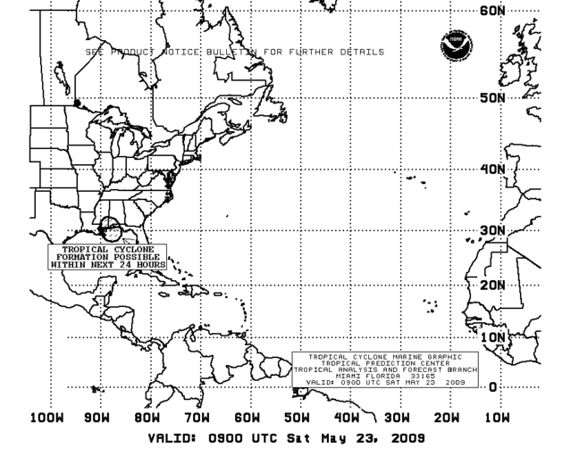
Dean4Storms wrote:This system may very well miss getting picked up by this trough, the longer it sits in the general area it is in and slower the development the better chance of this scenario IMO.


The 12z models started hinting that 93L would miss the trough coming in this weekend. The question is can 93L survive the shear and dry air after missing the trough and will it remain over water or die over CA. The odds are against 93L and it is likely the last Atlantic system for us to watch for 2008.
0 likes   

User avatar
gatorcane
S2K Supporter
S2K Supporter
Posts: 23499
Age: 46
Joined: Sun Mar 13, 2005 3:54 pm
Location: Boca Raton, FL

#42 Postby gatorcane » Mon Nov 03, 2008 8:54 pm

Is 93L starting to pick up some forward speed to the NW as of the past several hours? That is what I am seeing on the IR loops.

http://www.ssd.noaa.gov/goes/east/tatl/loop-avn.html
0 likes   

User avatar
Blown Away
S2K Supporter
S2K Supporter
Posts: 9862
Joined: Wed May 26, 2004 6:17 am

Re:

#43 Postby Blown Away » Mon Nov 03, 2008 9:15 pm

gatorcane wrote:Is 93L starting to pick up some forward speed to the NW as of the past several hours? That is what I am seeing on the IR loops.

http://www.ssd.noaa.gov/goes/east/tatl/loop-avn.html

Image

I was just about to post the same thing, I'd even go as far to say the low is relocating a bit farther N near the deeper convection. None of the models are showing this system moving much over the next 24-36 hours. Looking at the IR tonight it seems pretty clear the low is moving NW or NNW at a pretty good clip.
0 likes   

User avatar
wxman57
Moderator-Pro Met
Moderator-Pro Met
Posts: 22482
Age: 66
Joined: Sat Jun 21, 2003 8:06 pm
Location: Houston, TX (southwest)

Re:

#44 Postby wxman57 » Mon Nov 03, 2008 9:26 pm

gatorcane wrote:Is 93L starting to pick up some forward speed to the NW as of the past several hours? That is what I am seeing on the IR loops.

http://www.ssd.noaa.gov/goes/east/tatl/loop-avn.html


That loop is too low-res to see the LLC. A close-up loop clearly shows the LLC moving more northward and at a relatively slow speed. There's no convection near the center, so it's hard to see on a zoomed-out image like the one above.
0 likes   

User avatar
gatorcane
S2K Supporter
S2K Supporter
Posts: 23499
Age: 46
Joined: Sun Mar 13, 2005 3:54 pm
Location: Boca Raton, FL

Re: Re:

#45 Postby gatorcane » Mon Nov 03, 2008 9:30 pm

wxman57 wrote:
gatorcane wrote:Is 93L starting to pick up some forward speed to the NW as of the past several hours? That is what I am seeing on the IR loops.

http://www.ssd.noaa.gov/goes/east/tatl/loop-avn.html


That loop is too low-res to see the LLC. A close-up loop clearly shows the LLC moving more northward and at a relatively slow speed. There's no convection near the center, so it's hard to see on a zoomed-out image like the one above.


True its hard to make out a center tonight but the bulk of convection is spreading northward pretty quickly. The 18Z GFS shows a new Low developing farther north in the NW Caribbean and has it meandering around the NW Caribbean for several days. I can buy the relocation of the center but its likely the low moves NE through Cuba and the Bahamas ahead of the trough this weekend.

It's also interesting to note the two buoys in the NW Caribbean sea are seeing steady and significant pressure drops:

http://www.ndbc.noaa.gov/show_plot.php? ... _label=GMT
0 likes   

User avatar
MGC
S2K Supporter
S2K Supporter
Posts: 5792
Joined: Sun Mar 23, 2003 9:05 pm
Location: Pass Christian MS, or what is left.

Re: ATL: Invest 93L - Discussion

#46 Postby MGC » Mon Nov 03, 2008 10:49 pm

Most of the convection is occuring to the north of 93L which is likely being induced by the strong shear in that area. I'm starting to think that the only chance 93L has to develope is to move to the NE, with the shear. I'd say 93L is a little less organized this evening.....MGC
0 likes   

User avatar
HURAKAN
Professional-Met
Professional-Met
Posts: 46086
Age: 37
Joined: Thu May 20, 2004 4:34 pm
Location: Key West, FL
Contact:

#47 Postby HURAKAN » Mon Nov 03, 2008 11:24 pm

Image
0 likes   

User avatar
CourierPR
Category 5
Category 5
Posts: 1325
Age: 70
Joined: Tue Aug 31, 2004 7:53 pm
Location: Pompano Beach, Florida

Re: ATL: Invest 93L - Discussion

#48 Postby CourierPR » Tue Nov 04, 2008 7:00 am

This system looks much better organized this am.
0 likes   

User avatar
Matt-hurricanewatcher
Category 5
Category 5
Posts: 11649
Age: 38
Joined: Fri Nov 26, 2004 11:09 pm
Location: Portland,OR
Contact:

Re: ATL: Invest 93L - Discussion

#49 Postby Matt-hurricanewatcher » Tue Nov 04, 2008 7:37 am

13.2/81.3 possible LLC closing off but high southly shear.
0 likes   

User avatar
TheEuropean
Professional-Met
Professional-Met
Posts: 1793
Age: 58
Joined: Tue Sep 20, 2005 3:17 pm
Location: Voerde, Germany
Contact:

#50 Postby TheEuropean » Tue Nov 04, 2008 8:00 am

04/1145 UTC 12.5N 80.8W TOO WEAK 93L -- Atlantic
0 likes   

User avatar
HURAKAN
Professional-Met
Professional-Met
Posts: 46086
Age: 37
Joined: Thu May 20, 2004 4:34 pm
Location: Key West, FL
Contact:

#51 Postby HURAKAN » Tue Nov 04, 2008 8:25 am

TROPICAL WEATHER OUTLOOK
NWS TPC/NATIONAL HURRICANE CENTER MIAMI FL
700 AM EST TUE NOV 4 2008

FOR THE NORTH ATLANTIC...CARIBBEAN SEA AND THE GULF OF MEXICO...

A BROAD LOW PRESSURE AREA OVER THE SOUTHWESTERN CARIBBEAN SEA IS
DRIFTING NORTHWESTWARD. THE ASSOCIATED SHOWER ACTIVITY HAS CHANGED
LITTLE IN ORGANIZATION DURING THE PAST FEW HOURS. HOWEVER...SLOW
DEVELOPMENT OF THIS SYSTEM IS POSSIBLE OVER THE NEXT COUPLE OF
DAYS.

ELSEWHERE...TROPICAL CYCLONE FORMATION IS NOT EXPECTED DURING THE
NEXT 48 HOURS.

$$

FORECASTER BEVEN
0 likes   

User avatar
HURAKAN
Professional-Met
Professional-Met
Posts: 46086
Age: 37
Joined: Thu May 20, 2004 4:34 pm
Location: Key West, FL
Contact:

#52 Postby HURAKAN » Tue Nov 04, 2008 8:58 am

Best Track 12z:

AL, 93, 2008110412, , BEST, 0, 130N, 807W, 20, 1008
0 likes   

User avatar
wxman57
Moderator-Pro Met
Moderator-Pro Met
Posts: 22482
Age: 66
Joined: Sat Jun 21, 2003 8:06 pm
Location: Houston, TX (southwest)

Re: ATL: Invest 93L - Discussion

#53 Postby wxman57 » Tue Nov 04, 2008 9:58 am

Matt-hurricanewatcher wrote:13.2/81.3 possible LLC closing off but high southly shear.


That's the same center I've been tracking since Saturday. Definitely closed for the past 48 hours. It just lacks convection over it. Surface obs confirm the closed LLC today, as they have since Saturday. What's needed is convergence in toward the center. Convection is increasing just north of the center now - that could be the start of development.
0 likes   

User avatar
HURAKAN
Professional-Met
Professional-Met
Posts: 46086
Age: 37
Joined: Thu May 20, 2004 4:34 pm
Location: Key West, FL
Contact:

#54 Postby HURAKAN » Tue Nov 04, 2008 10:16 am

Image
0 likes   

User avatar
HURAKAN
Professional-Met
Professional-Met
Posts: 46086
Age: 37
Joined: Thu May 20, 2004 4:34 pm
Location: Key West, FL
Contact:

#55 Postby HURAKAN » Tue Nov 04, 2008 10:18 am

TROPICAL WEATHER DISCUSSION
NWS TPC/NATIONAL HURRICANE CENTER MIAMI FL
705 AM EST TUE NOV 04 2008

...SPECIAL FEATURE...
IN THE W CARIBBEAN...A SURFACE TROUGH EXTENDS FROM A 1008 MB
SURFACE LOW IN THE SW CARIBBEAN NEAR 13N81W TO 15N79W TO 18N78W.
LOW LEVEL CONVERGENCE NEAR THE LOW AND TROUGH...COMBINED WITH
DEEP MOISTURE AND UPPER LEVEL DIVERGENCE OVER THE W CARIBBEAN...
IS SUPPORTING SCATTERED SHOWERS AND THUNDERSTORMS FROM 13N-19N
BETWEEN 77W-82W...WITH ISOLATED SHOWERS AND THUNDERSTORMS S OF
11N W OF 80W. THIS ACTIVITY IS BECOMING SLIGHTLY BETTER
ORGANIZED...AND ADDITIONAL SLOW DEVELOPMENT OF THIS SYSTEM IS
POSSIBLE OVER THE NEXT COUPLE OF DAYS.
0 likes   

User avatar
HURAKAN
Professional-Met
Professional-Met
Posts: 46086
Age: 37
Joined: Thu May 20, 2004 4:34 pm
Location: Key West, FL
Contact:

#56 Postby HURAKAN » Tue Nov 04, 2008 10:35 am

Image
0 likes   

User avatar
gatorcane
S2K Supporter
S2K Supporter
Posts: 23499
Age: 46
Joined: Sun Mar 13, 2005 3:54 pm
Location: Boca Raton, FL

Re: ATL: Invest 93L - Discussion

#57 Postby gatorcane » Tue Nov 04, 2008 10:36 am

wxman57 wrote:
Matt-hurricanewatcher wrote:13.2/81.3 possible LLC closing off but high southly shear.


That's the same center I've been tracking since Saturday. Definitely closed for the past 48 hours. It just lacks convection over it. Surface obs confirm the closed LLC today, as they have since Saturday. What's needed is convergence in toward the center. Convection is increasing just north of the center now - that could be the start of development.


It's quite possible we will see a new low form farther north in the convection as the GFS has been suggesting for several runs now.
0 likes   

User avatar
HURAKAN
Professional-Met
Professional-Met
Posts: 46086
Age: 37
Joined: Thu May 20, 2004 4:34 pm
Location: Key West, FL
Contact:

#58 Postby HURAKAN » Tue Nov 04, 2008 10:38 am

Image
0 likes   

User avatar
Blown Away
S2K Supporter
S2K Supporter
Posts: 9862
Joined: Wed May 26, 2004 6:17 am

Re: ATL: Invest 93L - Discussion

#59 Postby Blown Away » Tue Nov 04, 2008 10:41 am

Image

The TAFB has 93L doing a sit and spin in the SW Caribbean for the next 72 hours.
0 likes   

Sanibel
Category 5
Category 5
Posts: 10348
Joined: Mon Aug 30, 2004 11:06 pm
Location: Offshore SW Florida

Re: ATL: Invest 93L - Discussion

#60 Postby Sanibel » Tue Nov 04, 2008 10:43 am

Seems like the axis center is under the convection near 15N-80 or so. But there's a weird elongation circulating down to the south and southwest that hasn't been pulled into a tighter center.

Cool here under a fog like cloud layer. Definitely tropically negative here.
0 likes   


Return to “2008”

Who is online

Users browsing this forum: No registered users and 93 guests