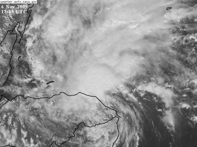
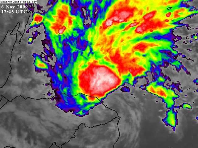
ATL : TROPICAL DEPRESSION IDA

Moderator: S2k Moderators

Message
Author
ericinmia
S2K Supporter
S2K Supporter
Posts: 1573
Joined: Fri Sep 12, 2003 11:15 pm
Location: Miami Lakes, FL

Re: ATL : TROPICAL DEPRESSION IDA

#1021 Postby ericinmia » Fri Nov 06, 2009 12:30 pm

It's so dead quiet around here... It really amazes me.

I think IDA really has potential to hit Cat1-2 before the Yucatan (Just my opinion). Once she hits the higher shear, we could either have a wilma scenario where it creates an outflow jet for IDA to maintain/intensify or the more likely scenario is that she begins to be ripped apart...

I wish I could "fast-forward" to see what the outcome would be... :)
-Eric
0 likes   

User avatar
cycloneye
Admin
Admin
Posts: 145354
Age: 68
Joined: Thu Oct 10, 2002 10:54 am
Location: San Juan, Puerto Rico

Re: ATL : TROPICAL DEPRESSION IDA - Models

#1022 Postby cycloneye » Fri Nov 06, 2009 12:36 pm

12z GFDL has a cat 2 in the central GOM and run ends as it moves east West of Tampa going slowly down in intensity.

http://moe.met.fsu.edu/cgi-bin/gfdltc2. ... =Animation
0 likes   
Visit the Caribbean-Central America Weather Thread where you can find at first post web cams,radars
and observations from Caribbean basin members Click Here

maxx9512
Tropical Storm
Tropical Storm
Posts: 114
Age: 65
Joined: Thu May 31, 2007 7:55 pm
Location: Cape Coral, Fl.

Re: ATL : TROPICAL DEPRESSION IDA

#1023 Postby maxx9512 » Fri Nov 06, 2009 12:36 pm

It does look like the center has now reached water. It also looks to have a slight ne motion (wobble) to it.
I guess now is when we will see what this storm has left to give. Does anyone see this?
0 likes   

Aric Dunn
Category 5
Category 5
Posts: 21238
Age: 42
Joined: Sun Sep 19, 2004 9:58 pm
Location: Ready for the Chase.
Contact:

#1024 Postby Aric Dunn » Fri Nov 06, 2009 12:36 pm

yeah it has pick up speed for sure its nearly off the coast. if this keeps up it will emerge in the next 2 hours .. way before it was forecast and well east of the track. Convection already migrating back to the center.. hehe its almost like the convection is on the coast waiting there and celebrating the return of the center :D
0 likes   

User avatar
Ivanhater
Storm2k Moderator
Storm2k Moderator
Posts: 11161
Age: 38
Joined: Fri Jul 01, 2005 8:25 am
Location: Pensacola

Re: ATL : TROPICAL DEPRESSION IDA - Models

#1025 Postby Ivanhater » Fri Nov 06, 2009 12:42 pm

GFDL is doing a loop in the gulf. Looks like a large system spreading a lot of wind and rain to the northern Gulfcoast. GFDL shows a large lopsided system, with most of the wind and storms to the NW of the center..interesting

Image
0 likes   
Michael

User avatar
hurricanefloyd5
Category 5
Category 5
Posts: 1659
Age: 44
Joined: Sun May 02, 2004 10:53 am
Location: Spartanburg
Contact:

Re: ATL : TROPICAL DEPRESSION IDA

#1026 Postby hurricanefloyd5 » Fri Nov 06, 2009 12:49 pm

LOL It will come to florida for sure and I am wondering if IDA will regain Hurricane STATUS again and omove into florida and should I batten down the Hatches yet????!!!!LOL well I will keep on top of this Storm and to see if it will still head for us here in florida as a hurriane or not a hurricane but a TS!!!!!!!!
0 likes   

User avatar
Blown Away
S2K Supporter
S2K Supporter
Posts: 10146
Joined: Wed May 26, 2004 6:17 am

Re: ATL : TROPICAL DEPRESSION IDA - Models

#1027 Postby Blown Away » Fri Nov 06, 2009 12:50 pm

cycloneye wrote:12z GFDL has a cat 2 in the central GOM and run ends as it moves east West of Tampa going slowly down in intensity.

http://moe.met.fsu.edu/cgi-bin/gfdltc2. ... =Animation


I think we are seeing a general consensus w/ Ida ultimately moving in the general area of Florida. Ultimately we might see a general Wilma type track (not intensity) and bring some gusty TS winds across Florida.
0 likes   
Hurricane Eye Experience: David 79, Irene 99, Frances 04, Jeanne 04, Wilma 05... EYE COMING MY WAY IN 2024…
Hurricane Brush Experience: Andrew 92, Erin 95, Floyd 99, Matthew 16, Irma 17, Ian 22, Nicole 22…

User avatar
cycloneye
Admin
Admin
Posts: 145354
Age: 68
Joined: Thu Oct 10, 2002 10:54 am
Location: San Juan, Puerto Rico

Re: ATL : TROPICAL DEPRESSION IDA - Models

#1028 Postby cycloneye » Fri Nov 06, 2009 12:55 pm

12z HWRF does a loop in the GOM and at the end targets Florida Penninsula.

http://moe.met.fsu.edu/cgi-bin/hwrftc2. ... =Animation
0 likes   
Visit the Caribbean-Central America Weather Thread where you can find at first post web cams,radars
and observations from Caribbean basin members Click Here

User avatar
Ivanhater
Storm2k Moderator
Storm2k Moderator
Posts: 11161
Age: 38
Joined: Fri Jul 01, 2005 8:25 am
Location: Pensacola

Re: ATL : TROPICAL DEPRESSION IDA - Models

#1029 Postby Ivanhater » Fri Nov 06, 2009 12:57 pm

Yep HWRF shows a loop as well in the gulf, very near the northern Gulfcoast spreading tropical storm conditions for much of the north central gulfcoast before looping and weakening...I think we will see a loop in the gulf with this storm, the timing and speed of Ida will say where the loop will occur

Image
0 likes   
Michael

User avatar
Ivanhater
Storm2k Moderator
Storm2k Moderator
Posts: 11161
Age: 38
Joined: Fri Jul 01, 2005 8:25 am
Location: Pensacola

Re: ATL : TROPICAL DEPRESSION IDA - Models

#1030 Postby Ivanhater » Fri Nov 06, 2009 12:59 pm

Again, the GFDL and HWRF are showing a loopsided system with most of the winds and storms to the Northwest, a loop will effect more people before weakening

Image

Image
0 likes   
Michael

User avatar
cycloneye
Admin
Admin
Posts: 145354
Age: 68
Joined: Thu Oct 10, 2002 10:54 am
Location: San Juan, Puerto Rico

Re: ATL : TROPICAL DEPRESSION IDA

#1031 Postby cycloneye » Fri Nov 06, 2009 1:00 pm

If anyone was wondering,why there is no advisory at 1 PM EST is because there are no watches or warnings at this time.The nexy advisory will be at 4 PM EST.
0 likes   
Visit the Caribbean-Central America Weather Thread where you can find at first post web cams,radars
and observations from Caribbean basin members Click Here

ozonepete
Professional-Met
Professional-Met
Posts: 4743
Joined: Mon Sep 07, 2009 3:23 pm
Location: From Ozone Park, NYC / Now in Brooklyn, NY

Re: ATL : TROPICAL DEPRESSION IDA

#1032 Postby ozonepete » Fri Nov 06, 2009 1:01 pm

cycloneye wrote:If anyone was wondering,why there is no advisory at 1 PM EST is because there are no watches or warnings at this time.The nexy advisory will be at 4 PM EST.


thanks, cyclone!
0 likes   

User avatar
AdamFirst
S2K Supporter
S2K Supporter
Posts: 2491
Age: 36
Joined: Thu Aug 14, 2008 10:54 am
Location: Port Saint Lucie, FL

#1033 Postby AdamFirst » Fri Nov 06, 2009 1:03 pm

Looks like northern part of the LLC is starting to dip its feet in the Caribbean. Convection attempting to wrap around on the left side.
0 likes   
Dolphins Marlins Canes Golden Panthers HEAT
Andrew 1992 - Irene 1999 - Frances 2004 - Jeanne 2004 - Wilma 2005 - Fay 2008 - Isaac 2012 - Matthew 2016 - Irma 2017 - Dorian 2019 - Ian 2022 - Nicole 2022 - Milton 2024

ozonepete
Professional-Met
Professional-Met
Posts: 4743
Joined: Mon Sep 07, 2009 3:23 pm
Location: From Ozone Park, NYC / Now in Brooklyn, NY

Re: ATL : TROPICAL DEPRESSION IDA

#1034 Postby ozonepete » Fri Nov 06, 2009 1:03 pm

Yes it's coming off the coast now, and from the looks of that nasty convection deepening on the north and west, this may re-intensify really rapidly.
0 likes   

User avatar
hurricanefloyd5
Category 5
Category 5
Posts: 1659
Age: 44
Joined: Sun May 02, 2004 10:53 am
Location: Spartanburg
Contact:

Re: ATL : TROPICAL DEPRESSION IDA

#1035 Postby hurricanefloyd5 » Fri Nov 06, 2009 1:04 pm

ozonepete wrote:Yes it's coming off the coast now, and from the looks of that nasty convection deepening on the north and west, this may re-intensify really rapidly.


it very well could do that!!!!! Can anyone say Hurricane?
0 likes   

User avatar
Blown Away
S2K Supporter
S2K Supporter
Posts: 10146
Joined: Wed May 26, 2004 6:17 am

Re: ATL : TROPICAL DEPRESSION IDA

#1036 Postby Blown Away » Fri Nov 06, 2009 1:05 pm

0 likes   
Hurricane Eye Experience: David 79, Irene 99, Frances 04, Jeanne 04, Wilma 05... EYE COMING MY WAY IN 2024…
Hurricane Brush Experience: Andrew 92, Erin 95, Floyd 99, Matthew 16, Irma 17, Ian 22, Nicole 22…

Aric Dunn
Category 5
Category 5
Posts: 21238
Age: 42
Joined: Sun Sep 19, 2004 9:58 pm
Location: Ready for the Chase.
Contact:

Re: ATL : TROPICAL DEPRESSION IDA

#1037 Postby Aric Dunn » Fri Nov 06, 2009 1:07 pm


yeah pretty much ..
0 likes   

User avatar
HURAKAN
Professional-Met
Professional-Met
Posts: 46086
Age: 38
Joined: Thu May 20, 2004 4:34 pm
Location: Key West, FL
Contact:

#1038 Postby HURAKAN » Fri Nov 06, 2009 1:08 pm

Image

Image

Coming offshore
0 likes   

User avatar
Weatherboy1
Category 5
Category 5
Posts: 1189
Age: 49
Joined: Mon Jul 05, 2004 1:50 pm
Location: Jupiter/Sarasota, FL

#1039 Postby Weatherboy1 » Fri Nov 06, 2009 1:08 pm

Yes, I agree that the circulation center is partially off the coast now. Next 4-8 hours will tell us if this thing can rapidly get her act together or if land has seriously disrupted her central core. My suspicion is that Ida will reintensify to a TS fairly quickly.
0 likes   

tolakram
Admin
Admin
Posts: 20009
Age: 62
Joined: Sun Aug 27, 2006 8:23 pm
Location: Florence, KY (name is Mark)

Re: ATL : TROPICAL DEPRESSION IDA

#1040 Postby tolakram » Fri Nov 06, 2009 1:09 pm

20 kts of shear off shore, heading to 30 knots the further north Ida gets.

Image

http://cimss.ssec.wisc.edu/tropic/real- ... g8shr.html

Conditions are not improving. :)
0 likes   
M a r k
- - - - -
Join us in chat: Storm2K Chatroom Invite. Android and IOS apps also available.

The posts in this forum are NOT official forecasts and should not be used as such. Posts are NOT endorsed by any professional institution or STORM2K.org. For official information and forecasts, please refer to NHC and NWS products.


Return to “2009”

Who is online

Users browsing this forum: No registered users and 12 guests