589
WTNT25 KNHC 261430
TCMAT5
TROPICAL STORM DANNY FORECAST/ADVISORY NUMBER 1
NWS TPC/NATIONAL HURRICANE CENTER MIAMI FL AL052009
1500 UTC WED AUG 26 2009
INTERESTS IN THE BAHAMAS AND THE SOUTHEASTERN UNITED STATES SHOULD
MONITOR THE PROGRESS OF DANNY.
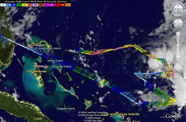
TROPICAL STORM CENTER LOCATED NEAR 24.9N 70.3W AT 26/1500Z
POSITION ACCURATE WITHIN 20 NM
PRESENT MOVEMENT TOWARD THE WEST-NORTHWEST OR 295 DEGREES AT 16 KT
ESTIMATED MINIMUM CENTRAL PRESSURE 1009 MB
MAX SUSTAINED WINDS 40 KT WITH GUSTS TO 50 KT.
34 KT.......120NE 0SE 0SW 120NW.
12 FT SEAS..120NE 75SE 75SW 120NW.
WINDS AND SEAS VARY GREATLY IN EACH QUADRANT. RADII IN NAUTICAL
MILES ARE THE LARGEST RADII EXPECTED ANYWHERE IN THAT QUADRANT.
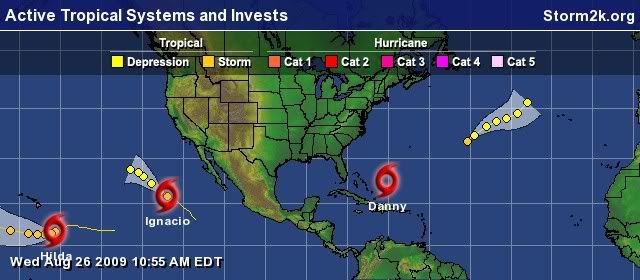
ATL: TROPICAL DEPRESSION DANNY (05L)
Moderator: S2k Moderators
-
HURAKAN

- Professional-Met

- Posts: 46084
- Age: 39
- Joined: Thu May 20, 2004 4:34 pm
- Location: Key West, FL
- Contact:
Re: ATL: TROPICAL STORM DANNY
0 likes
-
Hybridstorm_November2001

- S2K Supporter

- Posts: 2817
- Joined: Sat Aug 21, 2004 2:50 pm
- Location: SW New Brunswick, Canada
- Contact:
Re: ATL: Invest 92L
Sanibel wrote:You can imagine the panic if the CV belt was more favorable and Danny was a category 4 barrelling down this Floyd-like track!
I worry just as much, and often times more so, about homebrew like Danny. These types of systems can really sneak up on an area, then explosively deepen.
0 likes


-
Hybridstorm_November2001
- S2K Supporter
- Posts: 2817
- Joined: Sat Aug 21, 2004 2:50 pm
- Location: SW New Brunswick, Canada
- Contact:
-
ConvergenceZone
.gif)
- Category 5

- Posts: 5241
- Joined: Fri Jul 29, 2005 1:40 am
- Location: Northern California
Re: ATL: TROPICAL STORM DANNY
Wow, looks like the USA might dodge yet another bullet. How lucky can we keep getting???
0 likes
-
HouTXmetro

- Category 5
- Posts: 3949
- Joined: Sun Jun 13, 2004 6:00 pm
- Location: District of Columbia, USA
-
vbhoutex

- Storm2k Executive

- Posts: 29147
- Age: 74
- Joined: Wed Oct 09, 2002 11:31 pm
- Location: Cypress, TX
- Contact:
Re: ATL: Invest 92L
jenmrk wrote:vbhoutex wrote:jenmrk wrote:I just read at another forum that we now have Tropical Storm Danny, not sure if I am allowed to say what site.
Information coming in indicates that it will soon be named TS Danny, but nothing has been said officially yet that I am aware of.
I read it at Eastern Us Weather, I am sorry for jumping the gun, maybe I am better off lurking...lol!
No apologies needed. Don't just lurk. You just reported what you read. Stormm2k has a policy about not calling a storm by name until it is officially called, even if every indication says it should be called.
0 likes
-
ConvergenceZone
- Category 5
- Posts: 5241
- Joined: Fri Jul 29, 2005 1:40 am
- Location: Northern California
Re:
HouTXmetro wrote:The East Coast Megalopolis cities are in the cone!!! This will make MAJOR headlines.
It's not like it's a hurricane....
might be a good rain soaker though...
0 likes
-
HouTXmetro
- Category 5
- Posts: 3949
- Joined: Sun Jun 13, 2004 6:00 pm
- Location: District of Columbia, USA
Re: Re:
ConvergenceZone wrote:HouTXmetro wrote:The East Coast Megalopolis cities are in the cone!!! This will make MAJOR headlines.
It's not like it's a hurricane....
might be a good rain soaker though...
But the NHC is forcasting it to become a Hurricane.
0 likes
-
vbhoutex
- Storm2k Executive
- Posts: 29147
- Age: 74
- Joined: Wed Oct 09, 2002 11:31 pm
- Location: Cypress, TX
- Contact:
Re:
HouTXmetro wrote:The East Coast Megalopolis cities are in the cone!!! This will make MAJOR headlines.
I believe it is the CMC model that has this raking the whole East Coast all the way to NYC. It is the outlier to say the least. NOw that will bring major attention!!
0 likes

-
ConvergenceZone
- Category 5
- Posts: 5241
- Joined: Fri Jul 29, 2005 1:40 am
- Location: Northern California
Re: Re:
HouTXmetro wrote:ConvergenceZone wrote:HouTXmetro wrote:The East Coast Megalopolis cities are in the cone!!! This will make MAJOR headlines.
It's not like it's a hurricane....
might be a good rain soaker though...
But the NHC is forcasting it to become a Hurricane.
I just think that with the shear and everything, it's not going to happen...
0 likes
Re: ATL: TROPICAL STORM DANNY
what was all this discussion about a Florida threat?? seems to me it is already on a WNW track and following quite nicely along the model tracks as of this morning.
0 likes
-
Hybridstorm_November2001
- S2K Supporter
- Posts: 2817
- Joined: Sat Aug 21, 2004 2:50 pm
- Location: SW New Brunswick, Canada
- Contact:
Re: Re:
ConvergenceZone wrote:HouTXmetro wrote:The East Coast Megalopolis cities are in the cone!!! This will make MAJOR headlines.
It's not like it's a hurricane....
might be a good rain soaker though...
I hope your right and it does not, oh say turn into a hurricane or even a cat 3 or 4 at some point.
0 likes
-
ConvergenceZone
- Category 5
- Posts: 5241
- Joined: Fri Jul 29, 2005 1:40 am
- Location: Northern California
Re: Re:
Hybridstorm_November2001 wrote:ConvergenceZone wrote:HouTXmetro wrote:The East Coast Megalopolis cities are in the cone!!! This will make MAJOR headlines.
It's not like it's a hurricane....
might be a good rain soaker though...
I hope your right and it does not, oh say turn into a hurricane or even a cat 3 or 4 at some point.
well, conditions would have to RAPIDLY change for that to happen. Not saying conditios can't change. , just a very unlikely scenerio... (in my opinion)
0 likes
-
HURAKAN
- Professional-Met
- Posts: 46084
- Age: 39
- Joined: Thu May 20, 2004 4:34 pm
- Location: Key West, FL
- Contact:
Re: ATL: TROPICAL STORM DANNY
ConvergenceZone wrote:Wow, looks like the USA might dodge yet another bullet. How lucky can we keep getting???

If Danny were to have this track, it will be a direct strike on US soil. No bullet was dodged.
0 likes
-
ConvergenceZone
- Category 5
- Posts: 5241
- Joined: Fri Jul 29, 2005 1:40 am
- Location: Northern California
Re: ATL: TROPICAL STORM DANNY
You are right HURAKAN, I wasn't able to see that far out, sorry about that...
0 likes

Very interesting cone, I think if the models are going to go one way its going to trend west not east so the cone can only come closer to the East coast IMO but we shall see.
Looks like by the time it gets upto the NE its well on its way to being a extra tropical system but still looks pretty potent from the looks of things, so still a pretty interesting to watch!!!
Looks like by the time it gets upto the NE its well on its way to being a extra tropical system but still looks pretty potent from the looks of things, so still a pretty interesting to watch!!!
0 likes
Who is online
Users browsing this forum: No registered users and 6 guests