ATL: TROPICAL DEPRESSION DANNY (05L)

Moderator: S2k Moderators

Message
Author
User avatar
HURAKAN
Professional-Met
Professional-Met
Posts: 46086
Age: 38
Joined: Thu May 20, 2004 4:34 pm
Location: Key West, FL
Contact:

#1141 Postby HURAKAN » Wed Aug 26, 2009 12:18 pm

Image

Finally going north
0 likes   

Derek Ortt

#1142 Postby Derek Ortt » Wed Aug 26, 2009 12:20 pm

CMC does not intensify this overland.

It keeps it offshore until New England

GFS does not look to have shifted west at all. It looks like that is some other non-tropical low near New England that absorbs Danny
0 likes   

User avatar
storms NC
Tropical Storm
Tropical Storm
Posts: 247
Age: 69
Joined: Tue Sep 14, 2004 2:41 pm
Location: Coast of NC & southwest coast of Fla

#1143 Postby storms NC » Wed Aug 26, 2009 12:21 pm

A 100 miles off to the west would bring Danny in to the south of NC and up though NC east side of the state
0 likes   

User avatar
artist
Category 5
Category 5
Posts: 9792
Joined: Mon Jun 06, 2005 3:26 pm
Location: West Palm

#1144 Postby artist » Wed Aug 26, 2009 12:21 pm

000
URNT15 KNHC 261717
AF307 0205A DANNY HDOB 13 20090826
170800 2323N 07215W 8674 01352 0136 +174 +145 336003 004 003 003 03
170830 2324N 07215W 8893 01166 0153 +182 +173 300004 006 011 002 00
170900 2326N 07215W 9109 00916 0132 +196 +180 292005 005 014 001 00
170930 2328N 07214W 9331 00704 0114 +209 +197 279005 006 018 000 03
171000 2329N 07214W 9553 00487 0102 +225 +201 289005 006 013 001 03
171030 2331N 07214W 9590 00452 0098 +230 +205 297005 006 012 001 00
171100 2333N 07213W 9590 00452 0097 +229 +211 303006 006 015 000 03
171130 2335N 07213W 9590 00451 0097 +228 +210 305006 007 007 000 00
171200 2336N 07213W 9591 00450 0097 +227 +212 296006 006 001 003 00
171230 2338N 07212W 9589 00452 0096 +226 +213 304007 007 001 001 00
171300 2340N 07212W 9590 00451 0096 +225 +213 305006 006 003 001 00
171330 2341N 07212W 9590 00450 0096 +226 +210 313006 006 002 002 00
171400 2343N 07211W 9588 00452 0096 +225 +212 316006 006 004 001 00
171430 2345N 07211W 9591 00449 0095 +225 +213 315005 005 007 000 00
171500 2346N 07211W 9592 00448 0095 +226 +212 316005 005 001 002 00
171530 2348N 07210W 9592 00448 0094 +226 +213 308006 006 006 001 00
171600 2350N 07210W 9587 00451 0094 +225 +214 303006 006 007 000 00
171630 2351N 07209W 9598 00441 0094 +227 +213 294007 007 003 002 03
171700 2353N 07208W 9606 00434 0092 +230 +212 290007 008 009 000 03
171730 2354N 07207W 9589 00447 0091 +230 +207 295007 007 009 000 03
$$
0 likes   

User avatar
DanKellFla
Category 5
Category 5
Posts: 1291
Joined: Fri Mar 17, 2006 12:02 pm
Location: Lake Worth, Florida

#1145 Postby DanKellFla » Wed Aug 26, 2009 12:24 pm

3 out of 4 quadrents are nearly empty. But, Danny has a definite center of circulation. I am surprised it managed to get this far. I don't see how it is going to get too much stronger in the current conditions.
0 likes   

User avatar
HURAKAN
Professional-Met
Professional-Met
Posts: 46086
Age: 38
Joined: Thu May 20, 2004 4:34 pm
Location: Key West, FL
Contact:

#1146 Postby HURAKAN » Wed Aug 26, 2009 12:25 pm

Image

Now the plane is very close to the sea-surface
0 likes   

User avatar
artist
Category 5
Category 5
Posts: 9792
Joined: Mon Jun 06, 2005 3:26 pm
Location: West Palm

#1147 Postby artist » Wed Aug 26, 2009 12:29 pm

Product: Air Force Tropical RECCO Message (URNT11 KNHC)
Transmitted: 26th day of the month at 17:21Z
Aircraft: Air Force Aircraft (Last 3 digits of the tail number are 307)
Storm Number: 05
Storm Name: Danny (flight originating in the North Atlantic basin)
Mission Number: 2
Observation Number: 03

Mandatory Data...

Observation Time: Wednesday, 17:17Z
Radar Capability: Yes
Aircraft Altitude: Below 10,000 meters
Coordinates: 23.9N 72.1W
Location: 339 miles (546 km) to the ESE (104°) from Nassau, Bahamas.
Turbulence: None
Conditions Along Flight Route: In the clear
Pressure Altitude: 450 meters
Flight Level Wind: 5 knots (~ 5.8 mph) (Bearing was unavailable.)
- The above is a spot wind.
- Winds were obtained using doppler radar or inertial systems.
Flight Level Temperature: 23°C
Flight Level Dew Point: 21°C
Weather (within 30 nautical miles): Shower(s) (continuous or intermittent precipitation - from cumuliform clouds)
925 mb Surface Altitude: 762 geopotential meters

Optional Data...

Estimated Surface Wind Direction: Bearing was unavailable.
Estimated Surface Wind Speed: 5 knots (~ 5.8 mph)
0 likes   

User avatar
artist
Category 5
Category 5
Posts: 9792
Joined: Mon Jun 06, 2005 3:26 pm
Location: West Palm

#1148 Postby artist » Wed Aug 26, 2009 12:31 pm

000
URNT15 KNHC 261727
AF307 0205A DANNY HDOB 14 20090826
171800 2355N 07206W 9592 00445 0091 +230 +206 299007 007 006 000 03
171830 2356N 07205W 9592 00444 0091 +230 +204 308007 007 009 000 03
171900 2357N 07203W 9593 00443 0090 +229 +209 310007 008 006 000 03
171930 2358N 07202W 9593 00445 0090 +228 +214 306008 009 008 000 03
172000 2400N 07201W 9591 00445 0090 +229 +215 294008 008 007 000 03
172030 2401N 07200W 9593 00444 0090 +229 +216 279007 008 004 000 03
172100 2402N 07159W 9593 00442 0090 +229 +218 273008 008 009 000 00
172130 2403N 07157W 9589 00446 0089 +227 +219 266007 008 011 000 00
172200 2404N 07156W 9592 00443 0089 +229 +219 294007 008 999 999 03
172230 2406N 07156W 9593 00443 0090 +230 +214 294007 008 009 000 03
172300 2407N 07155W 9586 00449 0089 +228 +220 292008 009 002 001 03
172330 2408N 07154W 9594 00442 0089 +230 +217 294009 010 009 000 03
172400 2410N 07153W 9592 00442 0088 +227 +219 301010 010 010 000 00
172430 2411N 07152W 9594 00440 0088 +229 +218 294009 010 008 000 00
172500 2412N 07151W 9592 00442 0087 +230 +210 288009 009 005 000 03
172530 2413N 07149W 9593 00441 0087 +229 +213 281008 008 003 001 00
172600 2414N 07148W 9592 00441 0087 +227 +217 290007 007 004 000 03
172630 2415N 07147W 9593 00441 0087 +225 +218 300006 007 005 000 03
172700 2416N 07146W 9592 00440 0086 +225 +218 296007 007 002 000 00
172730 2417N 07144W 9593 00439 0086 +225 +216 297006 007 006 000 03
$$
0 likes   

User avatar
SEASON_CANCELED
Category 3
Category 3
Posts: 887
Joined: Mon Jul 06, 2009 5:17 am
Location: 8 Bit Charlie Sheen

Re:

#1149 Postby SEASON_CANCELED » Wed Aug 26, 2009 12:31 pm

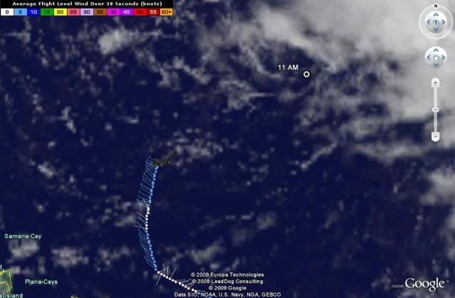
DanKellFla wrote:3 out of 4 quadrents are nearly empty. But, Danny has a definite center of circulation. I am surprised it managed to get this far. I don't see how it is going to get too much stronger in the current conditions.


Conditions will improve
0 likes   

Derek Ortt

#1150 Postby Derek Ortt » Wed Aug 26, 2009 12:32 pm

this is not hitting Florida. Nothing at all suggests that track. NOTHING!
0 likes   

Air Force Met
Military Met
Military Met
Posts: 4372
Age: 56
Joined: Tue Jul 08, 2003 9:30 am
Location: Roan Mountain, TN

Re: ATL: TROPICAL STORM DANNY

#1151 Postby Air Force Met » Wed Aug 26, 2009 12:33 pm

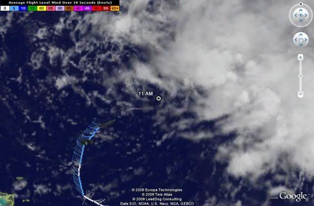
canes04 wrote:Forward speed has slowed down, also convection firing north and east of center.
Still think he will be close to the coast of FLA.


Uh.....No.
0 likes   

User avatar
SEASON_CANCELED
Category 3
Category 3
Posts: 887
Joined: Mon Jul 06, 2009 5:17 am
Location: 8 Bit Charlie Sheen

Re: ATL: TROPICAL STORM DANNY

#1152 Postby SEASON_CANCELED » Wed Aug 26, 2009 12:35 pm

That LLC is heading completly west with a small north component. Its going to need to make that turn soon. Within the last hour looks to be right on the TFP's but again. Watch the LLC not the convection
Last edited by SEASON_CANCELED on Wed Aug 26, 2009 12:37 pm, edited 1 time in total.
0 likes   

User avatar
artist
Category 5
Category 5
Posts: 9792
Joined: Mon Jun 06, 2005 3:26 pm
Location: West Palm

#1153 Postby artist » Wed Aug 26, 2009 12:35 pm

At 17:18:00Z (first observation), the observation was 339 miles (546 km) to the ESE (104°) from Nassau, Bahamas.
At 17:27:30Z (last observation), the observation was 356 miles (574 km) to the E (99°) from Nassau, Bahamas.
0 likes   

capepoint
Category 1
Category 1
Posts: 415
Joined: Sat Jul 19, 2008 7:13 pm
Location: Beaufort, NC

Re:

#1154 Postby capepoint » Wed Aug 26, 2009 12:36 pm

Derek Ortt wrote:this is not hitting Florida. Nothing at all suggests that track. NOTHING!


Guess you don't read much into the -removed- models, Derek? lol
0 likes   

User avatar
HURAKAN
Professional-Met
Professional-Met
Posts: 46086
Age: 38
Joined: Thu May 20, 2004 4:34 pm
Location: Key West, FL
Contact:

#1155 Postby HURAKAN » Wed Aug 26, 2009 12:37 pm

Image
0 likes   

User avatar
Thunder44
Category 5
Category 5
Posts: 5922
Age: 44
Joined: Mon Jun 09, 2003 7:53 pm
Location: New York City

Re:

#1156 Postby Thunder44 » Wed Aug 26, 2009 12:38 pm

Derek Ortt wrote:CMC does not intensify this overland.

It keeps it offshore until New England

GFS does not look to have shifted west at all. It looks like that is some other non-tropical low near New England that absorbs Danny


I don't another low forming near New England through 84 hours. It looks like the same storm to me.
0 likes   

User avatar
artist
Category 5
Category 5
Posts: 9792
Joined: Mon Jun 06, 2005 3:26 pm
Location: West Palm

#1157 Postby artist » Wed Aug 26, 2009 12:39 pm

000
URNT15 KNHC 261737
AF307 0205A DANNY HDOB 15 20090826
172800 2418N 07143W 9592 00441 0086 +226 +215 292006 007 004 000 00
172830 2420N 07142W 9592 00440 0085 +226 +209 286006 007 008 000 00
172900 2421N 07141W 9593 00439 0085 +226 +209 294005 006 004 000 03
172930 2422N 07139W 9593 00440 0085 +225 +210 305006 006 001 001 00
173000 2423N 07138W 9592 00439 0085 +228 +211 307005 005 004 000 00
173030 2424N 07137W 9592 00441 0085 +228 +210 290004 005 005 000 00
173100 2425N 07136W 9592 00440 0085 +225 +210 295005 006 004 000 00
173130 2426N 07134W 9591 00438 0085 +226 +209 293004 004 002 001 00
173200 2427N 07133W 9593 00438 0084 +230 +207 008003 003 004 000 00
173230 2428N 07132W 9591 00439 0083 +229 +208 020002 002 001 001 00
173300 2430N 07131W 9593 00436 0083 +229 +206 011002 002 003 001 03
173330 2431N 07129W 9592 00437 0083 +230 +208 006003 003 004 001 03
173400 2432N 07128W 9594 00435 0083 +227 +214 353002 002 002 001 00
173430 2433N 07127W 9590 00439 0082 +228 +215 327002 003 006 000 03
173500 2434N 07126W 9593 00437 0082 +229 +215 326002 003 006 000 03
173530 2435N 07124W 9590 00438 0082 +225 +216 320003 003 010 000 00
173600 2436N 07123W 9590 00438 0082 +225 +219 312003 003 008 000 03
173630 2437N 07122W 9593 00435 0082 +225 +220 300003 004 005 000 03
173700 2439N 07121W 9591 00436 0081 +223 +222 290003 004 006 000 03
173730 2440N 07120W 9593 00434 0081 +225 +222 312003 003 008 000 03
$$
0 likes   

Air Force Met
Military Met
Military Met
Posts: 4372
Age: 56
Joined: Tue Jul 08, 2003 9:30 am
Location: Roan Mountain, TN

Re: ATL: TROPICAL STORM DANNY

#1158 Postby Air Force Met » Wed Aug 26, 2009 12:40 pm

SEASON_CANCELED wrote:That LLC is heading completly west with a small north component. Its going to need to make that turn soon. Within the last hour looks to be right on the TFP's but again. Watch the LLC not the convection


Looks WNW to me...and I'm not looking at the convection.

http://wwwghcc.msfc.nasa.gov/cgi-bin/get-goes?satellite=GOES-E%20CONUS&lat=25&lon=-70&info=vis&zoom=1&width=2800&height=2000&type=Animation&numframes=15&map=latlon
0 likes   

Derek Ortt

#1159 Postby Derek Ortt » Wed Aug 26, 2009 12:40 pm

http://moe.met.fsu.edu/cgi-bin/gfstc2.c ... =Animation

it is a piece that breaks off of the current vorticity. That vorticity pattern is definitely not tropical
0 likes   

User avatar
massweathernet
Tropical Low
Tropical Low
Posts: 48
Joined: Mon May 18, 2009 1:52 pm
Location: Boston, MA
Contact:

Re: ATL: TROPICAL STORM DANNY

#1160 Postby massweathernet » Wed Aug 26, 2009 12:41 pm

FOX-25 BOSTON boldly announces their track forecast:

Image
0 likes   


Return to “2009”

Who is online

Users browsing this forum: No registered users and 6 guests