ATL : TROPICAL DEPRESSION IDA

Moderator: S2k Moderators

Message
Author
ericinmia
S2K Supporter
S2K Supporter
Posts: 1573
Joined: Fri Sep 12, 2003 11:15 pm
Location: Miami Lakes, FL

Re:

#1521 Postby ericinmia » Sat Nov 07, 2009 9:25 am

deltadog03 wrote::uarrow: The ridge at 500mb


Oh, I must've missed that... (does anyone have a feature map handy?)
Thanks
-Eric

Edit, got one:
Image
0 likes   

User avatar
HURAKAN
Professional-Met
Professional-Met
Posts: 46086
Age: 38
Joined: Thu May 20, 2004 4:34 pm
Location: Key West, FL
Contact:

#1522 Postby HURAKAN » Sat Nov 07, 2009 9:25 am

Image

Intense convection over the center
0 likes   

User avatar
Ivanhater
Storm2k Moderator
Storm2k Moderator
Posts: 11162
Age: 38
Joined: Fri Jul 01, 2005 8:25 am
Location: Pensacola

Re: ATL : TROPICAL STORM IDA

#1523 Postby Ivanhater » Sat Nov 07, 2009 9:26 am

Yeah Eric, notice the blow up of convection on the southeast side? As Ida moves further from the coast, the inflow is becoming better established on the Southeast side.
0 likes   
Michael

tgenius
S2K Supporter
S2K Supporter
Posts: 1160
Joined: Mon May 15, 2006 5:31 pm
Location: Miami, FL

Re: ATL : TROPICAL STORM IDA

#1524 Postby tgenius » Sat Nov 07, 2009 9:26 am

I meant about a direct landfall.. I was always expecting at least some rain from Ida. :)
0 likes   

jinftl
Category 5
Category 5
Posts: 4312
Joined: Tue Aug 31, 2004 4:47 pm
Location: fort lauderdale, fl

Re: ATL : TROPICAL STORM IDA

#1525 Postby jinftl » Sat Nov 07, 2009 9:26 am

True, the further north Ida gets, the weaker (and more likely to be extratropical) she will be....but if the track hooks east anywhere south of tampa bay, water temps are still over 80 deg (esp close to the coast)

Image

ocala wrote:
deltadog03 wrote:
Ivanhater wrote:GFS windshear forecast ..not good


IF** that map is correct then the GFS not only is telling you where it thinks she is going, but saying look out as well!


True, but the SST's in the Central Gulf aren't that warm.
0 likes   

User avatar
HURAKAN
Professional-Met
Professional-Met
Posts: 46086
Age: 38
Joined: Thu May 20, 2004 4:34 pm
Location: Key West, FL
Contact:

Re: ATL : TROPICAL STORM IDA

#1526 Postby HURAKAN » Sat Nov 07, 2009 9:27 am

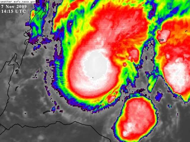
ericinmia wrote:She sure looks good.... on the loop, it's like watching a boiling pot of water.


Image

And it's only getting better.
0 likes   

User avatar
gatorcane
S2K Supporter
S2K Supporter
Posts: 23691
Age: 47
Joined: Sun Mar 13, 2005 3:54 pm
Location: Boca Raton, FL

Re: ATL : TROPICAL STORM IDA - Models

#1527 Postby gatorcane » Sat Nov 07, 2009 9:28 am

ericinmia wrote:What is supposed to make Ida make her eventual NW-WNW movement?


You mean NE-ENE movement at the end? That is because a CONUS trough is going to sweep through to the north and likely drop down into the Northern GOM. That trough will bring in strong Westerly winds and even WNW winds that could cause Ida to bend to the E or ESE at the end. Of course that hook to the SE would also be in an environment of very high shear and probably the entire cloud canopy of Ida would be ripped off to the ENE leaving a low-level swirl in the EGOM.
Last edited by gatorcane on Sat Nov 07, 2009 9:29 am, edited 1 time in total.
0 likes   

User avatar
deltadog03
Professional-Met
Professional-Met
Posts: 3580
Joined: Tue Jul 05, 2005 6:16 pm
Location: Macon, GA

#1528 Postby deltadog03 » Sat Nov 07, 2009 9:29 am

Image

12z nam coming out right now. Don't worry about what it shows with regards to the low placement and all. NAM looking terrible, but this just shows that the ridge over FL should allow for some NW movement.
0 likes   

Derek Ortt

#1529 Postby Derek Ortt » Sat Nov 07, 2009 9:29 am

this likely won't weaken at all due to SST, even though they are below 80F

That is only a general rule and does not apply at all during ET
0 likes   

User avatar
deltadog03
Professional-Met
Professional-Met
Posts: 3580
Joined: Tue Jul 05, 2005 6:16 pm
Location: Macon, GA

#1530 Postby deltadog03 » Sat Nov 07, 2009 9:30 am

It all depends on speed as well. The hwrf and gfdl still have this moving at a decent clip into the northern gom.
0 likes   

User avatar
MGC
S2K Supporter
S2K Supporter
Posts: 5899
Joined: Sun Mar 23, 2003 9:05 pm
Location: Pass Christian MS, or what is left.

Re: ATL : TROPICAL STORM IDA

#1531 Postby MGC » Sat Nov 07, 2009 9:31 am

SST are warm enough to maintain a TC in the central GOM. Up in the N GOM the SST drop into the mid 70's...so a TC would slowly die up there. Dry continental air and shear in the N GOM will kill a TC much faster than lower ocean heat content.....MGC
0 likes   

User avatar
Blown Away
S2K Supporter
S2K Supporter
Posts: 10147
Joined: Wed May 26, 2004 6:17 am

Re: ATL : TROPICAL STORM IDA

#1532 Postby Blown Away » Sat Nov 07, 2009 9:32 am

jlauderdal wrote:
Blown_away wrote:
12 UTC Best Track

In line with SSD Dvorak,45kts.

AL, 11, 2009110712, , BEST, 0, 174N, 841W, 45, 1000, TS

ftp://ftp.tpc.ncep.noaa.gov/atcf/tcweb/ ... 009.invest


:uarrow:
Looks like that center is east of 84W by a few degrees?

you mean a few 1/10ths of a degree, big difference.. a few degrees would have some people really excited


Oops, yep I meant a few 1/10ths and I don't think it's a big deal, I'm just intrigued with wobbles because they are usually not predicted. :D
0 likes   
Hurricane Eye Experience: David 79, Irene 99, Frances 04, Jeanne 04, Wilma 05... EYE COMING MY WAY IN 2024…
Hurricane Brush Experience: Andrew 92, Erin 95, Floyd 99, Matthew 16, Irma 17, Ian 22, Nicole 22…

ericinmia
S2K Supporter
S2K Supporter
Posts: 1573
Joined: Fri Sep 12, 2003 11:15 pm
Location: Miami Lakes, FL

Re: ATL : TROPICAL STORM IDA - Models

#1533 Postby ericinmia » Sat Nov 07, 2009 9:33 am

gatorcane wrote:
ericinmia wrote:What is supposed to make Ida make her eventual NW-WNW movement?


You mean NE-ENE movement at the end? That is because a CONUS trough is going to sweep through to the north and likely drop down into the Northern GOM. That trough will bring in strong Westerly winds and even WNW winds that could cause Ida to bend to the E or ESE at the end. Of course that hook to the SE would also be in an environment of very high shear and probably the entire cloud canopy of Ida would be ripped off to the ENE leaving a low-level swirl in the EGOM.


No, I meant NW-WNW as written. :)
All of the guidance says that today she should commence going NW-WNW. I was wondering what was causing that, and if those features were really as strong as the models claim. Also, would the strength of Ida have an affect on how far west she would move?
-Eric
0 likes   

User avatar
Evil Jeremy
S2K Supporter
S2K Supporter
Posts: 5463
Age: 32
Joined: Mon Apr 10, 2006 2:10 pm
Location: Los Angeles, CA

Re: ATL : TROPICAL STORM IDA

#1534 Postby Evil Jeremy » Sat Nov 07, 2009 9:33 am

Wow, Ida is strengthening. I hope the NHC does not play it conservative since land is now in danger. This could easily be a 60 MPH storm right now. My main concern though, is when is Ida going to start making that turn to the NW?
0 likes   
Frances 04 / Jeanne 04 / Katrina 05 / Wilma 05 / Fay 08 / Debby 12 / Andrea 13 / Colin 16 / Hermine 16 / Matthew 16 / Irma 17

jinftl
Category 5
Category 5
Posts: 4312
Joined: Tue Aug 31, 2004 4:47 pm
Location: fort lauderdale, fl

Re: Re:

#1535 Postby jinftl » Sat Nov 07, 2009 9:34 am

HAZARDOUS WEATHER OUTLOOK
NATIONAL WEATHER SERVICE TAMPA BAY RUSKIN FL
510 AM EST SAT NOV 7 2009

THIS HAZARDOUS WEATHER OUTLOOK IS FOR WEST CENTRAL AND SOUTHWEST
FLORIDA.

..DAYS TWO THROUGH SEVEN...SUNDAY THROUGH FRIDAY.

...TROPICAL IMPACT...
TROPICAL STORM IDA HAS EMERGED INTO THE NORTHWEST CARRIBEAN SEA
THIS MORNING. CONSIDERABLE UNCERTAINTY REMAINS IN THE LONG TERM
FORECAST OF THIS STORM...BOTH IN LOCATION AND INTENSITY. ALL
INTERESTS ARE ENCOURAGED TO CONSULT THE LATEST GUIDANCE AND
INFORMATION FROM THE NATIONAL HURRICANE CENTER CONCERNING THE
POSSIBLE IMPACTS FROM IDA
.

...WIND AND SEA IMPACT...
EAST TO NORTHEAST WINDS WILL CONTINUE AT AROUND 20 KNOTS OFF THE
COAST. THESE STRONGER WINDS ARE EXPECTED TO CONTINUE THROUGH THE
WEEKENED AND INTO EARLY NEXT WEEK. FISHERMEN AND OTHER SMALL CRAFT
OPREATORS MAY WISH TO POSTPONE TRIPS UNTIL CONDITIONS IMPROVE
.

robbielyn wrote:
jdray wrote:
robbielyn wrote:Tampa as always will dodge a bullet too. I'm thinking big bend being the eastern most part crossing into georgia northern fl and ga watch out for tornadoes!! :cry:


Yup, all my neighbors will say "it's gonna miss us" and totally forget about the tornadic threat.

Tampa Bay NWS is making it sound like another day in paradise almost. I believe we will have some rain and some wind but nothing too impressive. I don't even think tornadoes will be much of a factor from hernando(spring hill) south. I think tornadoes will be a ne fl ga event. Why? Cause it usually is. Our shield stays up year round lol.
0 likes   

ericinmia
S2K Supporter
S2K Supporter
Posts: 1573
Joined: Fri Sep 12, 2003 11:15 pm
Location: Miami Lakes, FL

Re:

#1536 Postby ericinmia » Sat Nov 07, 2009 9:35 am

deltadog03 wrote:
12z nam coming out right now. Don't worry about what it shows with regards to the low placement and all. NAM looking terrible, but this just shows that the ridge over FL should allow for some NW movement.


Cool, thanks.

In theory here how is that ridge stacked... would it move a weaker storm the same as a stronger one? Just curious?
0 likes   

User avatar
MGC
S2K Supporter
S2K Supporter
Posts: 5899
Joined: Sun Mar 23, 2003 9:05 pm
Location: Pass Christian MS, or what is left.

Re: ATL : TROPICAL STORM IDA

#1537 Postby MGC » Sat Nov 07, 2009 9:35 am

It will be interesting to see the extent of Ida's wind field since the passage overland.....MGC
0 likes   

User avatar
fci
S2K Supporter
S2K Supporter
Posts: 3324
Joined: Tue Sep 14, 2004 10:29 am
Location: Lake Worth, FL

Re: ATL : TROPICAL STORM IDA

#1538 Postby fci » Sat Nov 07, 2009 9:36 am

tgenius wrote:So the developments overnight lead me to believe that South FL is going to dodge a bullet with Ida...


I believe that we are not close to "dodging a bullet"!
Looking back at Irene, I see the same type of forecast albeit a little closer to SFL than Ida.
Forecast was a north movement and she went NNE and then crossed the Southern Peninsula.
Climatologically this is the most likely result.
In my opinion, we are far from getting an "all clear" in South Florida!

This has been a strange season but a threat to the Northern Gulf coming from the NW Carib in November is really strange and I still don't buy it. I still expect, if Ida survives; a sharp right turn well before the Northern Gulf coast.

Just my opinion...

Personal Forecast Disclaimer:
The posts in this forum are NOT official forecast and should not be used as such. They are just the opinion of the poster and may or may not be backed by sound meteorological data. They are NOT endorsed by any professional institution or storm2k.org. For official information, please refer to the NHC and NWS products.
0 likes   

User avatar
AdamFirst
S2K Supporter
S2K Supporter
Posts: 2491
Age: 36
Joined: Thu Aug 14, 2008 10:54 am
Location: Port Saint Lucie, FL

Re: ATL : TROPICAL STORM IDA

#1539 Postby AdamFirst » Sat Nov 07, 2009 9:37 am

Look at the forecast track....there is nobody in Florida that is "dodging a bullet" right now.
0 likes   
Dolphins Marlins Canes Golden Panthers HEAT
Andrew 1992 - Irene 1999 - Frances 2004 - Jeanne 2004 - Wilma 2005 - Fay 2008 - Isaac 2012 - Matthew 2016 - Irma 2017 - Dorian 2019 - Ian 2022 - Nicole 2022 - Milton 2024

User avatar
gatorcane
S2K Supporter
S2K Supporter
Posts: 23691
Age: 47
Joined: Sun Mar 13, 2005 3:54 pm
Location: Boca Raton, FL

Re: ATL : TROPICAL STORM IDA - Models

#1540 Postby gatorcane » Sat Nov 07, 2009 9:37 am

ericinmia wrote:
gatorcane wrote:
ericinmia wrote:What is supposed to make Ida make her eventual NW-WNW movement?


You mean NE-ENE movement at the end? That is because a CONUS trough is going to sweep through to the north and likely drop down into the Northern GOM. That trough will bring in strong Westerly winds and even WNW winds that could cause Ida to bend to the E or ESE at the end. Of course that hook to the SE would also be in an environment of very high shear and probably the entire cloud canopy of Ida would be ripped off to the ENE leaving a low-level swirl in the EGOM.


No, I meant NW-WNW as written. :)
All of the guidance says that today she should commence going NW-WNW. I was wondering what was causing that, and if those features were really as strong as the models claim. Also, would the strength of Ida have an affect on how far west she would move?
-Eric


That is because there is a mid-level ridge with a center over Texas/LA area right now that is pushing East over the Northern GOM and then will eventually be over Florida and Bahamas. There is also another ridge east of Ida right now and a trough over the Western GOM. So Ida was moving North but should start to bump up against the Texas/LA ridge today and move more NW or even WNW. Strength probably won't matter, in fact if Ida is stronger than expected may even cause more of a WNW movement as she bumps up against that ridge.

You can see the Texas/LA ridge clearly here in this WV image. See the arc (like an inverted U shape) over the Central CONUS?

Image
0 likes   


Return to “2009”

Who is online

Users browsing this forum: No registered users and 3 guests