ATL: TROPICAL LOW ex-FRED (ex-07L)

Moderator: S2k Moderators

Message
Author
Aric Dunn
Category 5
Category 5
Posts: 21238
Age: 42
Joined: Sun Sep 19, 2004 9:58 pm
Location: Ready for the Chase.
Contact:

Re: ATL: TROPICAL LOW ex-FRED (ex-07L)

#1621 Postby Aric Dunn » Mon Sep 21, 2009 6:51 am

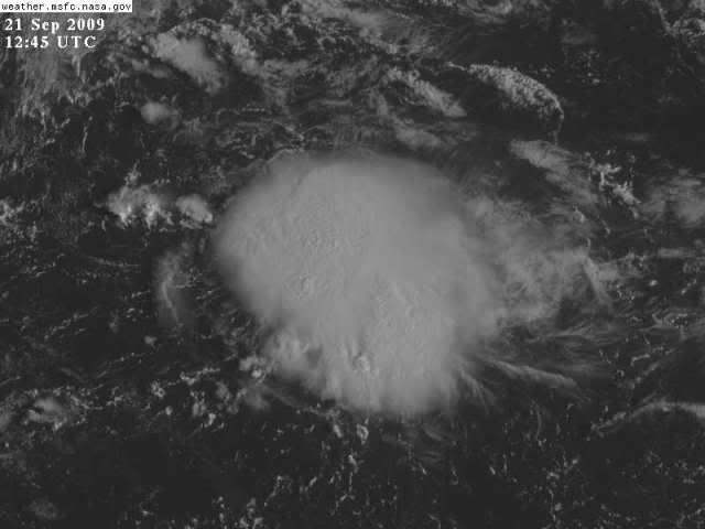
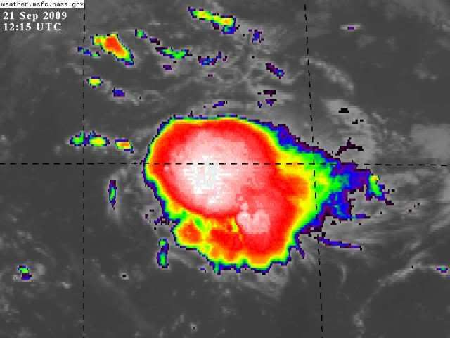
ronjon wrote:Looks like the LLC has tucked under the western convection near 29.5N-73.5W accoding to shortwave IR SAT - need VIS to confirm. Wow, ole freddie has more lives than a cat. Shear has dropped way down - does it develop or pulse down again. Gonna run smack into a DLM ridge near SC or possibly get pushed SW back toward FL.

http://www.ssd.noaa.gov/goes/east/watl/loop-ir2.html


yeah the deeper this gets the more west to SW it will go..

Once the shear drops even more the llc will likely be pulled or quickly reform under the deep convection where the most convergence is
0 likes   

User avatar
deltadog03
Professional-Met
Professional-Met
Posts: 3580
Joined: Tue Jul 05, 2005 6:16 pm
Location: Macon, GA

#1622 Postby deltadog03 » Mon Sep 21, 2009 6:55 am

Whats crazy is this is going to go right over the gulf stream fairly slowly. If** shear does truely relax, then.....
0 likes   

IvanSurvivor
Tropical Storm
Tropical Storm
Posts: 152
Joined: Wed Aug 20, 2008 12:12 am
Location: Pensacola Florida (Warrington)

#1623 Postby IvanSurvivor » Mon Sep 21, 2009 7:08 am

Uh-Oh :P
Good morning all...are there any models coming out soon that will show the latest projected direction? Last one in the other thread is from mid afternoon yesterday.
0 likes   

User avatar
Normandy
Category 5
Category 5
Posts: 2293
Joined: Sun Oct 10, 2004 12:31 am
Location: Houston, TX

Re: ATL: TROPICAL LOW ex-FRED (ex-07L)

#1624 Postby Normandy » Mon Sep 21, 2009 7:14 am

Hey guys,
Interesting developments this morning. Fred still has a good amount of low level vorticity, and the new convection that just sprung up could deepen it more. The question is, if this redevelops will the NHC assign the name Fred to it? Its been forever since advisories stopped on Fred.
0 likes   

User avatar
wxman57
Moderator-Pro Met
Moderator-Pro Met
Posts: 22978
Age: 67
Joined: Sat Jun 21, 2003 8:06 pm
Location: Houston, TX (southwest)

Re: ATL: TROPICAL LOW ex-FRED (ex-07L)

#1625 Postby wxman57 » Mon Sep 21, 2009 7:27 am

There's no evidence of a surface circulation center in the surface obs around what's left of Fred. Pressures near the western edge of the convection are about 1019mb.

That said, the GFS does indicate an upper-level ridge briefly building over Fred's remnants tonight and tomorrow morning. I can see some signs that shear is already beginning to relax over the area of storms. If the convection can persist, then it may be able to regenerate a surface circulation later today or tonight. But with a deep trof to its east and a strengthening ridge over the Gulf, wind shear should increase quite significantly across the SW Atlantic by Wednesday morning. Anything there would be ripped apart.
0 likes   

jconsor
Professional-Met
Professional-Met
Posts: 551
Joined: Mon Jun 30, 2008 9:31 pm
Location: Jerusalem, Israel
Contact:

Re: ATL: TROPICAL LOW ex-FRED (ex-07L)

#1626 Postby jconsor » Mon Sep 21, 2009 7:44 am

Fred will most likely be inland by Wednesday. The window of opportunity for development is mainly between now and Tuesday.
0 likes   

User avatar
alan1961
Category 2
Category 2
Posts: 771
Joined: Mon Mar 20, 2006 11:58 am
Location: Derby, Derbyshire, England
Contact:

Re: ATL: TROPICAL LOW ex-FRED (ex-07L)

#1627 Postby alan1961 » Mon Sep 21, 2009 7:47 am

The convective cockroach is growing...into godzilla? :lol:
0 likes   

User avatar
boca
Category 5
Category 5
Posts: 6367
Age: 60
Joined: Mon Dec 15, 2003 8:49 am
Location: Boca Raton,FL

Re: ATL: TROPICAL LOW ex-FRED (ex-07L)

#1628 Postby boca » Mon Sep 21, 2009 7:53 am

If and a big if Fred where to develop more what steering level would you look at? Wouldn't Fred be more of a threat to the Carolina's vs Going SW towards Florida?
0 likes   

User avatar
Emmett_Brown
Category 5
Category 5
Posts: 1432
Joined: Wed Aug 24, 2005 9:10 pm
Location: Sarasota FL

#1629 Postby Emmett_Brown » Mon Sep 21, 2009 7:58 am

So far, Quickscat doesn't see a closed LLC either, but this is so small, QS probably would miss it anyway until it gets better established:

Image
0 likes   

User avatar
Emmett_Brown
Category 5
Category 5
Posts: 1432
Joined: Wed Aug 24, 2005 9:10 pm
Location: Sarasota FL

Re: ATL: TROPICAL LOW ex-FRED (ex-07L)

#1630 Postby Emmett_Brown » Mon Sep 21, 2009 8:00 am

boca wrote:If and a big if Fred where to develop more what steering level would you look at? Wouldn't Fred be more of a threat to the Carolina's vs Going SW towards Florida?


My guess would be to use the shallow steering like below:

Image
0 likes   

User avatar
HURAKAN
Professional-Met
Professional-Met
Posts: 46086
Age: 38
Joined: Thu May 20, 2004 4:34 pm
Location: Key West, FL
Contact:

#1631 Postby HURAKAN » Mon Sep 21, 2009 8:03 am

Image

Image

Latest
0 likes   

User avatar
boca
Category 5
Category 5
Posts: 6367
Age: 60
Joined: Mon Dec 15, 2003 8:49 am
Location: Boca Raton,FL

Re: ATL: TROPICAL LOW ex-FRED (ex-07L)

#1632 Postby boca » Mon Sep 21, 2009 8:03 am

Emmett_Brown wrote:
boca wrote:If and a big if Fred where to develop more what steering level would you look at? Wouldn't Fred be more of a threat to the Carolina's vs Going SW towards Florida?


My guess would be to use the shallow steering like below:

Image


Looking at that map it would be a S Carolina issue if it got its act together.
0 likes   

User avatar
storms NC
Tropical Storm
Tropical Storm
Posts: 247
Age: 69
Joined: Tue Sep 14, 2004 2:41 pm
Location: Coast of NC & southwest coast of Fla

Re: ATL: TROPICAL LOW ex-FRED (ex-07L)

#1633 Postby storms NC » Mon Sep 21, 2009 8:06 am

jconsor wrote:Fred will most likely be inland by Wednesday. The window of opportunity for development is mainly between now and Tuesday.


You are right. Would give rain to SC-NC Not much more than that. to close to go into TS or a Hurricane. Would be some nice rain here on the coast.
0 likes   

Aric Dunn
Category 5
Category 5
Posts: 21238
Age: 42
Joined: Sun Sep 19, 2004 9:58 pm
Location: Ready for the Chase.
Contact:

#1634 Postby Aric Dunn » Mon Sep 21, 2009 8:12 am

There has been a closed circ this entire time.. just needed to point that out again .. its not directly under the convection but has always at least been a closed wind field..
0 likes   

User avatar
ronjon
Category 5
Category 5
Posts: 4822
Joined: Fri Aug 19, 2005 5:17 pm
Location: Hernando Beach, FL

Re:

#1635 Postby ronjon » Mon Sep 21, 2009 8:15 am

Aric Dunn wrote:There has been a closed circ this entire time.. just needed to point that out again .. its not directly under the convection but has always at least been a closed wind field..


Yeah, now it has some heavy convection over it - but this happened Saturday morning and I thought it would take off from there - will it pulse down again or blossom?
0 likes   

Aric Dunn
Category 5
Category 5
Posts: 21238
Age: 42
Joined: Sun Sep 19, 2004 9:58 pm
Location: Ready for the Chase.
Contact:

#1636 Postby Aric Dunn » Mon Sep 21, 2009 8:15 am

This where the broad area center is .. its very clear that we have a closed wind field..

30.43° N 73.41° W near the NW edge on the convection I imagine as i said earlier that reforming under or closer the convection is likely.. if convection continues.
0 likes   

Aric Dunn
Category 5
Category 5
Posts: 21238
Age: 42
Joined: Sun Sep 19, 2004 9:58 pm
Location: Ready for the Chase.
Contact:

Re: Re:

#1637 Postby Aric Dunn » Mon Sep 21, 2009 8:17 am

ronjon wrote:
Aric Dunn wrote:There has been a closed circ this entire time.. just needed to point that out again .. its not directly under the convection but has always at least been a closed wind field..


Yeah, now it has some heavy convection over it - but this happened Saturday morning and I thought it would take off from there - will it pulse down again or blossom?


yeah nut saturday the convection was much less than this..
0 likes   

User avatar
ronjon
Category 5
Category 5
Posts: 4822
Joined: Fri Aug 19, 2005 5:17 pm
Location: Hernando Beach, FL

Re: ATL: TROPICAL LOW ex-FRED (ex-07L)

#1638 Postby ronjon » Mon Sep 21, 2009 8:23 am

Checked the steering winds - deeper system definitely gets pushed SW over FL.

http://cimss.ssec.wisc.edu/tropic2/real-time/dlmmain.php?&basin=atlantic&sat=wg8&prod=dlm3&zoom=&time=
0 likes   

User avatar
Emmett_Brown
Category 5
Category 5
Posts: 1432
Joined: Wed Aug 24, 2005 9:10 pm
Location: Sarasota FL

Re: ATL: TROPICAL LOW ex-FRED (ex-07L)

#1639 Postby Emmett_Brown » Mon Sep 21, 2009 8:29 am

ronjon wrote:Checked the steering winds - deeper system definitely gets pushed SW over FL.

http://cimss.ssec.wisc.edu/tropic2/real-time/dlmmain.php?&basin=atlantic&sat=wg8&prod=dlm3&zoom=&time=


Yup, that is true. Before they stopped running yesterday, the general idea the models showed for the path was W/NW as a shallow system, and bending back to the W/SW as it deepened.
0 likes   

User avatar
Emmett_Brown
Category 5
Category 5
Posts: 1432
Joined: Wed Aug 24, 2005 9:10 pm
Location: Sarasota FL

#1640 Postby Emmett_Brown » Mon Sep 21, 2009 8:30 am

Upper level divergence is improving:

Image
0 likes   


Return to “2009”

Who is online

Users browsing this forum: No registered users and 4 guests