ATL: TROPICAL DEPRESSION DANNY (05L)

Moderator: S2k Moderators

Message
Author
Air Force Met
Military Met
Military Met
Posts: 4372
Age: 56
Joined: Tue Jul 08, 2003 9:30 am
Location: Roan Mountain, TN

Re:

#1701 Postby Air Force Met » Thu Aug 27, 2009 12:19 pm

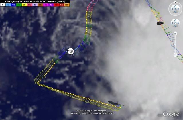
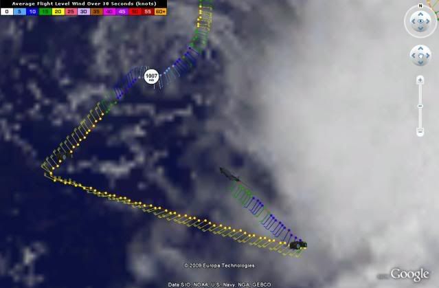
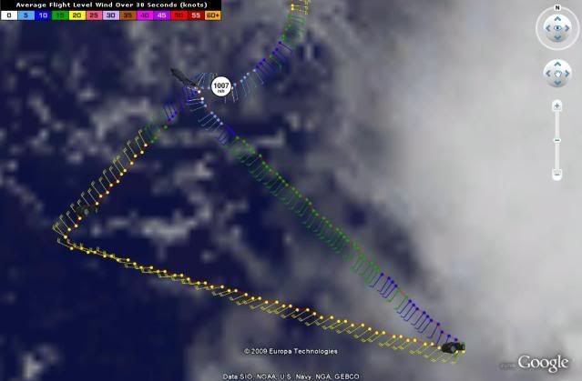
Dean4Storms wrote:Danny has become decoupled from his mid and upper level circulation. Right now Danny's LLC is moving along with the lower atmospheric flow which is westward.


Right now its not much moving at all...Slow drift west at best.
0 likes   

User avatar
Blown Away
S2K Supporter
S2K Supporter
Posts: 10145
Joined: Wed May 26, 2004 6:17 am

Re: ATL: TROPICAL STORM DANNY

#1702 Postby Blown Away » Thu Aug 27, 2009 12:20 pm

Maybe the LLC will reform back near 28N /70W, looks like a little spin in that area. Big friggen mess rate now!
0 likes   

User avatar
Lowpressure
S2K Supporter
S2K Supporter
Posts: 2032
Age: 58
Joined: Sun Sep 14, 2003 9:17 am
Location: Charlotte, North Carolina

#1703 Postby Lowpressure » Thu Aug 27, 2009 12:24 pm

The next NHC discussion ought to be a real good read. Watch them try to explain this mess in a professional manner.
0 likes   

User avatar
artist
Category 5
Category 5
Posts: 9792
Joined: Mon Jun 06, 2005 3:26 pm
Location: West Palm

#1704 Postby artist » Thu Aug 27, 2009 12:25 pm

000
URNT15 KNHC 271723
AF307 0505A DANNY HDOB 27 20090827
171400 2613N 07237W 9665 00407 0123 +240 +205 240021 021 020 000 00
171430 2612N 07235W 9665 00408 0124 +237 +205 239021 021 020 000 00
171500 2612N 07232W 9663 00410 0124 +236 +206 238021 021 021 000 00
171530 2611N 07230W 9667 00407 0125 +237 +205 235021 021 020 000 00
171600 2610N 07228W 9666 00407 0125 +236 +206 234020 020 022 000 00
171630 2610N 07226W 9665 00408 0126 +235 +206 233021 021 021 000 00
171700 2609N 07223W 9661 00412 0125 +236 +206 233021 021 022 000 00
171730 2609N 07221W 9665 00408 0126 +236 +205 233020 021 019 000 00
171800 2608N 07219W 9664 00409 0125 +237 +205 234020 021 020 000 00
171830 2608N 07217W 9665 00408 0125 +237 +205 234021 022 022 000 00
171900 2607N 07214W 9665 00408 0125 +236 +205 233021 022 019 000 00
171930 2607N 07212W 9665 00409 0126 +237 +205 232021 022 020 000 00
172000 2606N 07210W 9666 00409 0126 +237 +205 231022 022 021 000 00
172030 2605N 07208W 9662 00413 0127 +237 +205 230022 023 021 000 00
172100 2605N 07205W 9660 00414 0127 +237 +205 228022 023 020 000 03
172130 2605N 07203W 9663 00412 0126 +239 +203 217021 023 999 999 03
172200 2607N 07203W 9668 00407 0126 +239 +203 210015 016 999 999 03
172230 2608N 07205W 9669 00407 0127 +237 +203 214012 013 999 999 03
172300 2609N 07207W 9660 00415 0127 +236 +204 202013 013 023 000 03
172330 2610N 07209W 9664 00410 0126 +236 +204 203013 013 015 001 00
$$
0 likes   

User avatar
BensonTCwatcher
Category 5
Category 5
Posts: 1046
Joined: Sat Aug 28, 2004 10:11 pm
Location: Southport NC

#1705 Postby BensonTCwatcher » Thu Aug 27, 2009 12:26 pm

Yep, Danny has not read the definitive manual "How to Be a Tropical System"
0 likes   

User avatar
artist
Category 5
Category 5
Posts: 9792
Joined: Mon Jun 06, 2005 3:26 pm
Location: West Palm

#1706 Postby artist » Thu Aug 27, 2009 12:26 pm

At 17:14:00Z (first observation), the observation was 305 miles (491 km) to the ENE (75°) from Nassau, Bahamas.
At 17:23:30Z (last observation), the observation was 332 miles (535 km) to the ENE (77°) from Nassau, Bahamas.
0 likes   

User avatar
HURAKAN
Professional-Met
Professional-Met
Posts: 46086
Age: 38
Joined: Thu May 20, 2004 4:34 pm
Location: Key West, FL
Contact:

#1707 Postby HURAKAN » Thu Aug 27, 2009 12:26 pm

Image
0 likes   

User avatar
robbielyn
Category 5
Category 5
Posts: 1298
Joined: Wed May 07, 2003 9:45 am
Location: brooksville, fl

#1708 Postby robbielyn » Thu Aug 27, 2009 12:27 pm

http://www.ssd.noaa.gov/goes/east/watl/loop-vis.html according to this visible, I see just to the se of the naked llc, another strong swirl below the main convection, however i am now seeing the main convection having a circulation and its going north. I think this is going to go nne I'd forget that naked swirls path. Thats not where the storm is going. IMO :) I think in the end the nhc track will be within the cone. Nothing radical here. Granted that ull below louisana isn't moving but with the llc eventually relocating in the main convection, it's already feeling a northern tug the models maybe be on to something afterall. Im betting the carolinas will miss this one.
0 likes   

User avatar
artist
Category 5
Category 5
Posts: 9792
Joined: Mon Jun 06, 2005 3:26 pm
Location: West Palm

#1709 Postby artist » Thu Aug 27, 2009 12:36 pm

000
URNT15 KNHC 271733
AF307 0505A DANNY HDOB 28 20090827
172400 2612N 07210W 9676 00395 0121 +240 +203 208013 014 014 001 00
172430 2613N 07212W 9674 00390 0114 +240 +201 218013 014 018 000 00
172500 2614N 07213W 9661 00401 0112 +238 +199 217013 014 016 001 00
172530 2615N 07214W 9668 00393 0111 +239 +198 218014 014 019 000 03
172600 2616N 07216W 9665 00397 0111 +237 +196 219013 014 017 000 00
172630 2617N 07217W 9664 00397 0111 +238 +194 217014 014 018 000 00
172700 2618N 07218W 9662 00398 0111 +238 +193 219014 014 017 000 00
172730 2619N 07219W 9663 00398 0110 +238 +192 218015 016 016 000 00
172800 2621N 07221W 9665 00396 0110 +239 +192 219015 015 019 000 00
172830 2622N 07222W 9666 00395 0110 +240 +191 220014 014 018 000 00
172900 2623N 07223W 9667 00394 0110 +240 +191 216014 014 016 000 00
172930 2624N 07224W 9664 00395 0109 +240 +191 212014 015 019 000 03
173000 2625N 07226W 9664 00394 0108 +240 +190 216014 015 016 000 00
173030 2626N 07227W 9664 00394 0108 +240 +190 215015 015 017 000 00
173100 2627N 07228W 9665 00393 0107 +239 +190 213015 016 019 000 00
173130 2628N 07229W 9664 00394 0107 +240 +190 216015 015 019 000 00
173200 2629N 07231W 9666 00391 0107 +240 +190 215016 016 020 000 00
173230 2630N 07232W 9665 00392 0106 +240 +191 212015 016 018 000 00
173300 2632N 07233W 9663 00393 0106 +240 +191 213015 015 018 000 00
173330 2633N 07234W 9664 00391 0105 +240 +191 213015 015 019 000 00
$$


At 17:24:00Z (first observation), the observation was 332 miles (534 km) to the ENE (76°) from Nassau, Bahamas.
At 17:33:30Z (last observation), the observation was 314 miles (506 km) to the ENE (71°) from Nassau, Bahamas.
0 likes   

Orrie
Tropical Low
Tropical Low
Posts: 10
Joined: Thu Aug 27, 2009 1:00 am

Re: ATL: TROPICAL STORM DANNY

#1710 Postby Orrie » Thu Aug 27, 2009 12:37 pm

Sanibel wrote:Stalling. Probably prior to right turn. Must be some westerly shear on this.
I see No evidence that the LLC is stalling or even slowing for that matter..however that being said there is a MLC to the east of the exposed center that may become the new LLC later today..and that complex of energy is crawling (this may be what your referring to ) Even if thats the case I see nothing that would pull this poleward attm. in fact there is ridging to the north and west of the system. (per wv loop) a 1020 mb high is in the proximity. the ull over the gulf coast has created a complex set-up around Danny . the model guidance hasnt preformed as badly as everyone has said either ..especially given the synoptic mess of the ec right now.
0 likes   

User avatar
HURAKAN
Professional-Met
Professional-Met
Posts: 46086
Age: 38
Joined: Thu May 20, 2004 4:34 pm
Location: Key West, FL
Contact:

#1711 Postby HURAKAN » Thu Aug 27, 2009 12:41 pm

Image
0 likes   

User avatar
M_0331
S2K Supporter
S2K Supporter
Posts: 137
Joined: Fri Sep 10, 2004 12:05 pm
Location: SE COAST, SC

Re: ATL: TROPICAL STORM DANNY

#1712 Postby M_0331 » Thu Aug 27, 2009 12:41 pm

Orrie wrote:
Sanibel wrote:Stalling. Probably prior to right turn. Must be some westerly shear on this.
I see No evidence that the LLC is stalling or even slowing for that matter..however that being said there is a MLC to the east of the exposed center that may become the new LLC later today..and that complex of energy is crawling (this may be what your referring to ) Even if thats the case I see nothing that would pull this poleward attm. in fact there is ridging to the north and west of the system. (per wv loop) a 1020 mb high is in the proximity. the ull over the gulf coast has created a complex set-up around Danny . the model guidance hasnt preformed as badly as everyone has said either ..especially given the synoptic mess of the ec right now.


Pretty heavy for your first post
0 likes   

User avatar
artist
Category 5
Category 5
Posts: 9792
Joined: Mon Jun 06, 2005 3:26 pm
Location: West Palm

#1713 Postby artist » Thu Aug 27, 2009 12:42 pm

ok, when I do a 10 image loop now by clicking on Latitude= 28.23° N Longitude= 72.44° W (X=378 Y=132)
from http://weather.msfc.nasa.gov/GOES/goeseasthurr.html
I am now seeing clouds moving beneath this swirl off to the ne, not in tandem. Is anyone else seeing this? Do a rapid loop and tell me if I am losing it or not please. :ggreen:
0 likes   

tolakram
Admin
Admin
Posts: 20009
Age: 62
Joined: Sun Aug 27, 2006 8:23 pm
Location: Florence, KY (name is Mark)

Re:

#1714 Postby tolakram » Thu Aug 27, 2009 12:45 pm

artist wrote:ok, when I do a 10 image loop now by clicking on Latitude= 28.23° N Longitude= 72.44° W (X=378 Y=132)
from http://weather.msfc.nasa.gov/GOES/goeseasthurr.html
I am now seeing clouds moving beneath this swirl off to the ne, not in tandem. Is anyone else seeing this? Do a rapid loop and tell me if I am losing it or not please. :ggreen:


YES, for hours now. :p

And for the first poster who must live on the east coast.

http://rammb.cira.colostate.edu/ramsdis ... _floater_1

Put your finger on the LLC and tell me if it's moved. :)
0 likes   

jpigott
Category 2
Category 2
Posts: 692
Joined: Fri Sep 03, 2004 1:31 pm
Location: North Palm Beach, Florida

Re: ATL: TROPICAL STORM DANNY

#1715 Postby jpigott » Thu Aug 27, 2009 12:45 pm

http://rammb.cira.colostate.edu/ramsdis ... _floater_1

almost looks like Danny's exposed center moves south of west in the most recent frame. Wonder if it is getting sucked back towards the convection. Convection looks to be waning
0 likes   

User avatar
ronjon
Category 5
Category 5
Posts: 4822
Joined: Fri Aug 19, 2005 5:17 pm
Location: Hernando Beach, FL

Re: ATL: TROPICAL STORM DANNY - Computer Models

#1716 Postby ronjon » Thu Aug 27, 2009 12:47 pm

12Z GFDL is further west - now clips cape cod. 12Z GFS strikes Conn-RI now.

http://moe.met.fsu.edu/cgi-bin/gfdltc2.cgi?time=2009082712-danny05l&field=Sea+Level+Pressure&hour=Animation
0 likes   

Sanibel
Category 5
Category 5
Posts: 10375
Joined: Mon Aug 30, 2004 11:06 pm
Location: Offshore SW Florida

Re: ATL: TROPICAL STORM DANNY

#1717 Postby Sanibel » Thu Aug 27, 2009 12:47 pm

If it's trapped it will probably break poleward. Otherwise a high will develop over it and push it west (Or even SW in an arc west), but the cut-off GOM ULL probably won't allow that. The shortwave should boot the whole thing along - right???
0 likes   

User avatar
artist
Category 5
Category 5
Posts: 9792
Joined: Mon Jun 06, 2005 3:26 pm
Location: West Palm

#1718 Postby artist » Thu Aug 27, 2009 12:54 pm

000
URNT15 KNHC 271743
AF307 0505A DANNY HDOB 29 20090827
173400 2634N 07236W 9664 00392 0105 +240 +191 215016 017 015 001 00
173430 2635N 07237W 9666 00388 0105 +240 +191 214016 016 018 000 00
173500 2636N 07238W 9666 00390 0104 +240 +191 213016 016 020 000 00
173530 2637N 07239W 9664 00389 0103 +240 +192 212016 017 020 000 03
173600 2638N 07241W 9664 00391 0102 +240 +192 210016 017 018 000 00
173630 2639N 07242W 9663 00389 0102 +240 +192 208017 017 019 000 00
173700 2640N 07243W 9662 00391 0101 +240 +192 208018 018 017 000 00
173730 2641N 07245W 9662 00389 0101 +240 +193 210017 018 019 000 00
173800 2642N 07246W 9667 00385 0100 +240 +193 213019 020 019 000 03
173830 2644N 07247W 9664 00387 0099 +240 +193 214019 020 020 000 00
173900 2645N 07248W 9664 00387 0099 +240 +193 211018 018 021 000 03
173930 2646N 07250W 9663 00386 0098 +240 +193 209018 019 021 000 00
174000 2647N 07251W 9667 00382 0098 +239 +193 217018 019 021 000 00
174030 2648N 07252W 9662 00387 0097 +239 +193 221017 018 022 000 00
174100 2649N 07254W 9666 00383 0096 +240 +193 223016 017 021 000 03
174130 2650N 07255W 9663 00384 0095 +239 +193 218016 017 017 001 00
174200 2651N 07256W 9666 00381 0095 +240 +193 225015 015 020 000 00
174230 2652N 07257W 9664 00381 0093 +241 +194 225015 015 019 000 03
174300 2653N 07259W 9664 00380 0092 +240 +194 225016 016 020 000 00
174330 2654N 07300W 9664 00381 0091 +241 +194 224016 016 019 000 00
$$


At 17:34:00Z (first observation), the observation was 313 miles (503 km) to the ENE (71°) from Nassau, Bahamas.
At 17:43:30Z (last observation), the observation was 298 miles (480 km) to the ENE (65°) from Nassau, Bahamas.
0 likes   

User avatar
carolina_73
Tropical Storm
Tropical Storm
Posts: 148
Joined: Wed Jul 23, 2008 1:30 am

Re: ATL: TROPICAL STORM DANNY

#1719 Postby carolina_73 » Thu Aug 27, 2009 12:55 pm

jpigott wrote:http://rammb.cira.colostate.edu/ramsdis/online/loop_640.asp?product=tropical_ge_4km_visir2_floater_1

almost looks like Danny's exposed center moves south of west in the most recent frame. Wonder if it is getting sucked back towards the convection. Convection looks to be waning

Looking at that loop shows how disorganized Danny is at the moment. The LLC does seem to slightly drop to SSW in that last frame. Looks like he has been moving due W for some time now. The track has to shift W bigtime if he doesn't start to move N soon. I think that that ULL is sucking him in. JMO
0 likes   

User avatar
HURAKAN
Professional-Met
Professional-Met
Posts: 46086
Age: 38
Joined: Thu May 20, 2004 4:34 pm
Location: Key West, FL
Contact:

#1720 Postby HURAKAN » Thu Aug 27, 2009 12:58 pm

Image
0 likes   


Return to “2009”

Who is online

Users browsing this forum: No registered users and 3 guests