ATL : TROPICAL DEPRESSION IDA
Moderator: S2k Moderators
-
Evil Jeremy

- S2K Supporter

- Posts: 5463
- Age: 32
- Joined: Mon Apr 10, 2006 2:10 pm
- Location: Los Angeles, CA

Re: ATL : HURRICANE IDA
Sanibel wrote:Could somebody interpret the 130mph vortex data message wind for the 883 millibar level? Is that a 113KT flight level wind?
It's what the dropsonde that was dropped from the plane, recorded at that level.
0 likes
-
MGC

- S2K Supporter
- Posts: 5940
- Joined: Sun Mar 23, 2003 9:05 pm
- Location: Pass Christian MS, or what is left.
Re: ATL : HURRICANE IDA
Wow, looking at the IR loop Ida does not look to be a 90mph hurricane. Sure wish a eye would pop out, would make it much easier to track. Wondering when I wake if Ida might be a Cat-3...and I thought the GFDL was dead wrong.....MGC
0 likes
-
Hurricaneman

- Category 5

- Posts: 7404
- Age: 45
- Joined: Tue Aug 31, 2004 3:24 pm
- Location: central florida
Re:
bahamaswx wrote:Definitely doesn't look like a 100mph storm.
just like earl in 1998 didnt look like a cat 2 and Ida now doesnt look like one, but looks can be decieving
0 likes
-
Hurricanewatcher2007

- Category 2

- Posts: 578
- Joined: Sat Jul 05, 2008 8:10 pm
Re: ATL : HURRICANE IDA - Recon
979mb pressure
000
URNT15 KNHC 080728
AF306 0311A IDA HDOB 30 20091108
072030 2036N 08513W 6962 03094 0015 +062 +048 118068 071 062 028 00
072100 2035N 08514W 6966 03080 9998 +069 +049 125072 075 064 025 00
072130 2034N 08516W 6975 03065 9994 +070 +052 133068 072 066 019 00
072200 2033N 08517W 6968 03069 9988 +071 +055 136071 074 065 018 00
072230 2031N 08518W 6968 03065 9974 +077 +057 134065 067 061 015 00
072300 2030N 08520W 6971 03056 9947 +095 +058 129062 062 062 007 00
072330 2029N 08521W 6968 03051 9924 +106 +060 127064 068 062 009 03
072400 2028N 08522W 6931 03086 9910 +106 +064 119050 059 067 009 03
072430 2026N 08523W 6920 03094 9893 +113 +069 114039 041 068 007 03
072500 2025N 08524W 6957 03039 9878 +119 +075 112035 036 067 004 03
072530 2023N 08525W 6971 03014 9849 +133 +082 116037 041 063 003 00
072600 2021N 08526W 6967 03009 9811 +158 +089 112027 035 048 003 00
072630 2020N 08527W 6970 03004 9802 +163 +098 104014 017 036 002 03
072700 2018N 08527W 6967 03007 9792 +173 +106 210006 009 024 002 00
072730 2016N 08527W 6976 03000 9796 +175 +114 269014 015 024 002 00
072800 2015N 08528W 6954 03030 9802 +169 +122 284015 016 017 003 03
072830 2013N 08529W 6977 03005 9791 +177 +129 287022 024 023 001 00
072900 2012N 08531W 6961 03024 9780 +189 +134 296023 025 025 003 00
072930 2011N 08532W 6960 03032 9792 +185 +139 305031 035 038 002 00
073000 2010N 08533W 6976 03024 9797 +186 +142 301041 043 052 005 00
$$
;
0 likes
-
maxx9512
- Tropical Storm

- Posts: 114
- Age: 66
- Joined: Thu May 31, 2007 7:55 pm
- Location: Cape Coral, Fl.
Re: ATL : HURRICANE IDA
Does it look like the west shift has stopped and a more of northerly path has resumed?
It it just I am tired of looking the sat. pictures and its late? I think this is what I see but could be wrong.
It's hard to tell using AVN pictures. Maybe just time to rest the eyes and check back later!
It it just I am tired of looking the sat. pictures and its late? I think this is what I see but could be wrong.
It's hard to tell using AVN pictures. Maybe just time to rest the eyes and check back later!
0 likes
-
Hurricanewatcher2007
- Category 2
- Posts: 578
- Joined: Sat Jul 05, 2008 8:10 pm

-
Tampa Bay Hurricane

- Category 5
- Posts: 5597
- Age: 38
- Joined: Fri Jul 22, 2005 7:54 pm
- Location: St. Petersburg, FL
Re: ATL : HURRICANE IDA
-5 mb/hr
Obvious Rapid Intensification
I think there is a fair chance of Ida reaching Category 3 by Midday
Sunday; small but very intense eye.
Obvious Rapid Intensification
I think there is a fair chance of Ida reaching Category 3 by Midday
Sunday; small but very intense eye.
0 likes
-
JonathanBelles
- Professional-Met

- Posts: 11430
- Age: 35
- Joined: Sat Dec 24, 2005 9:00 pm
- Location: School: Florida State University (Tallahassee, FL) Home: St. Petersburg, Florida
- Contact:
Re: ATL : HURRICANE IDA
This is going to be a very controversial excerpt from the NHC Discussion at 4am.....sounds like the NHC is not anticipating...right now... to have to issue any tropical storm watches/warnings (and no hurricane watches) for the Gulf Coast. This is because of the expectation Ida will be extratropical and the high wind/coastal flood/etc advisories will be handled by the local NWS offices instead.
Important to note they are not saying such conditions won't take place...they just won't take place as a 'tropical system'. Why do i have a feeling not everyone will agree with this move? Obviously, they can change their minds if conditions warrant....we are still 48-60 hours away from the system approaching the U.S. coast.


THE OFFICIAL FORECAST SHOWS TROPICAL STORM FORCE WINDS REACHING
PORTIONS OF THE U.S. GULF COAST IN A COUPLE OF DAYS. HOWEVER...
SINCE IDA IS EXPECTED TO BEGIN UNDERGOING EXTRATROPICAL TRANSITION
AROUND THAT TIME...THESE HAZARDS ARE BEING HANDLED BY LOCAL
NATIONAL WEATHER SERVICE OFFICES ALONG THE GULF COAST IN THEIR
PRODUCT SUITE WITH MARINE AND COASTAL FLOOD WATCHES... WARNINGS
...AND ADVISORIES.
Important to note they are not saying such conditions won't take place...they just won't take place as a 'tropical system'. Why do i have a feeling not everyone will agree with this move? Obviously, they can change their minds if conditions warrant....we are still 48-60 hours away from the system approaching the U.S. coast.
THE OFFICIAL FORECAST SHOWS TROPICAL STORM FORCE WINDS REACHING
PORTIONS OF THE U.S. GULF COAST IN A COUPLE OF DAYS. HOWEVER...
SINCE IDA IS EXPECTED TO BEGIN UNDERGOING EXTRATROPICAL TRANSITION
AROUND THAT TIME...THESE HAZARDS ARE BEING HANDLED BY LOCAL
NATIONAL WEATHER SERVICE OFFICES ALONG THE GULF COAST IN THEIR
PRODUCT SUITE WITH MARINE AND COASTAL FLOOD WATCHES... WARNINGS
...AND ADVISORIES.
Last edited by jinftl on Sun Nov 08, 2009 4:14 am, edited 1 time in total.
0 likes
-
ozonepete
- Professional-Met
- Posts: 4743
- Joined: Mon Sep 07, 2009 3:23 pm
- Location: From Ozone Park, NYC / Now in Brooklyn, NY
Re: ATL : HURRICANE IDA
jinftl wrote:This is going to be a very controversial excerpt from the NHC Discussion at 4am.....they are not anticipating...right now... to have to issue any tropical storm watches/warnings (and no hurricane watches) for the Gulf Coast because of the expectation Ida will be extratrop and the high wind/coastal flood/etc advisories will be handled by the local NWS offices instead.
Important to note they are not saying such conditions won't take place...they just won't take place as a 'tropical system'. Why do i have a feeling not everyone will agree with this move?
THE OFFICIAL FORECAST SHOWS TROPICAL STORM FORCE WINDS REACHING
PORTIONS OF THE U.S. GULF COAST IN A COUPLE OF DAYS. HOWEVER...
SINCE IDA IS EXPECTED TO BEGIN UNDERGOING EXTRATROPICAL TRANSITION
AROUND THAT TIME...THESE HAZARDS ARE BEING HANDLED BY LOCAL
NATIONAL WEATHER SERVICE OFFICES ALONG THE GULF COAST IN THEIR
PRODUCT SUITE WITH MARINE AND COASTAL FLOOD WATCHES... WARNINGS
...AND ADVISORIES.
I understand it. Just why not wait?
0 likes
-
Janie2006

- Category 5
- Posts: 1329
- Joined: Mon Sep 18, 2006 3:28 pm
- Location: coastal Ms aka home of the hurricanes
Re: ATL : HURRICANE IDA
jinftl wrote:This is going to be a very controversial excerpt from the NHC Discussion at 4am.....they are not anticipating...right now... to have to issue any tropical storm watches/warnings (and no hurricane watches) for the Gulf Coast because of the expectation Ida will be extratrop and the high wind/coastal flood/etc advisories will be handled by the local NWS offices instead.
Important to note they are not saying such conditions won't take place...they just won't take place as a 'tropical system'. Why do i have a feeling not everyone will agree with this move? Obviously, they can change their minds if conditions warrant....we are still 48-72 hours away from the system approaching the U.S. coast.
THE OFFICIAL FORECAST SHOWS TROPICAL STORM FORCE WINDS REACHING
PORTIONS OF THE U.S. GULF COAST IN A COUPLE OF DAYS. HOWEVER...
SINCE IDA IS EXPECTED TO BEGIN UNDERGOING EXTRATROPICAL TRANSITION
AROUND THAT TIME...THESE HAZARDS ARE BEING HANDLED BY LOCAL
NATIONAL WEATHER SERVICE OFFICES ALONG THE GULF COAST IN THEIR
PRODUCT SUITE WITH MARINE AND COASTAL FLOOD WATCHES... WARNINGS
...AND ADVISORIES.
...and this is where it gets really dicey for the NHC. It seems at this point they're betting everything on Ida going extratropical in around 48-72 hours or so. That may very well be the case, but if it doesn't turn out like that then they've really dropped the ball as far as warnings/advisories go. There isn't all that much time remaining, so they'll have to make up their minds rather quickly now: do they issue TS/hurricand advisories or let the local NWS handle things? I'm not convinced this is written in stone yet. They may need to change their opinions.
0 likes
Re: ATL : HURRICANE IDA
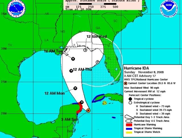
I do agree it was early to make this statement. The current forecast map has the system as a hurricane still southeast of Buras at 12am Tuesday and then as a 50 mph extratropical system at 12 am Wednesday near Panama City. That's pushing it really close!
But there is still time....most watches don't go out until we are in the 48 hour window. And the thinking is very confident that what we are talking about is tropical storm, not hurricane conditions. Big difference in terms of how folks would prepare. I know by me, for example, we have to work if there is a tropical storm warning, but we don't work if there is a hurricane warning. If you are in a flood prone coastal area, yes, there is preparation to do. But if you live away from the beach, it is doubtful you would shutter the house and load up on supplies for what will probably be a day with 45 or 50 mph wind gusts.
The NHC is not saying there won't be bad conditions, they are just saying they don't issue warnings for such systems. The NWS Offices would handle that, just as they handle flood warnings, gale warnings, blizzard warnings, winter storm warnings, etc. The severity of a warning is not diminished if it comes from a NWS Office.
Case in point, as of now, there is already a Coastal Flood Watch in effect for parts of Southeast Louisiana that uses serious language that vulnerable residents should heed (and which will likely be extended beyond Tueday). If folks are waiting to see if the NHC says there will be coastal flooding from Ida, there is no need to do that. A storm doesn't have to have a name to cause havoc.
...COASTAL FLOOD WATCH REMAINS IN EFFECT THROUGH TUESDAY
MORNING...
RESIDENTS AND INTERESTS ALONG THE COAST ARE URGED TO MAKE
PREPARATIONS FOR MODERATE TO SIGNIFICANT INUNDATION THAT MAY LAST
FOR 2 TO 3 DAYS AS TIDES RISE AS HIGH AS 3 TO 4 FEET AND POSSIBLY
5 FEET ABOVE NORMAL AT TIMES THROUGH TUESDAY MORNING...ESPECIALLY
ALONG EAST FACING SHORES IN ST BERNARD AND PLAQUEMINES PARISH...
AND ALONG HANCOCK COUNTY. CURRENTLY...TIDES ARE RUNNING ABOUT
1 FOOT ABOVE NORMAL. AS WINDS INCREASE OVER THE GULF OF MEXICO ON
SUNDAY...TIDES ARE EXPECTED TO CONTINUE TO INCREASE BY SUNDAY
NIGHT.
ozonepete wrote:I understand it. Just why not wait?
0 likes
-
Janie2006
- Category 5
- Posts: 1329
- Joined: Mon Sep 18, 2006 3:28 pm
- Location: coastal Ms aka home of the hurricanes
Re: ATL : HURRICANE IDA - Advisories
000
WTNT41 KNHC 080900
TCDAT1
HURRICANE IDA DISCUSSION NUMBER 17
NWS TPC/NATIONAL HURRICANE CENTER MIAMI FL AL112009
300 AM CST SUN NOV 08 2009
DATA FROM THE AIR FORCE HURRICANE HUNTER AIRCRAFT SUGGEST THAT THE
INTENSIFICATION OF IDA HAS HALTED...AT LEAST TEMPORARILY. THE
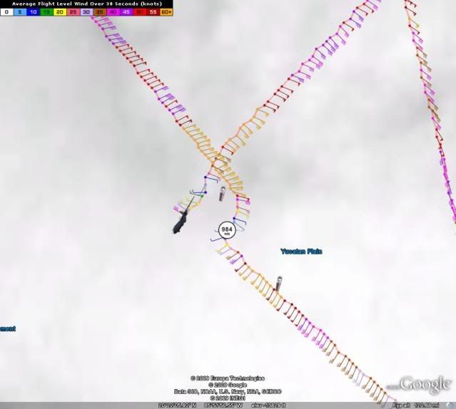
LATEST PRESSURE MEASURED ON A PASS THROUGH THE CENTER WAS 984
MB...AND THE INITIAL INTENSITY IS HELD AT 80 KT FOR THIS ADVISORY.
THE INTENSITY FORECAST SHOWS SOME STRENGTHENING IN THE SHORT
TERM...AS IDA WILL REMAIN OVER VERY WARM WATERS THROUGH THE NEXT 24
HOURS. BEYOND THAT TIME...IDA WILL BEGIN TO MOVE OVER MUCH COOLER
WATERS...BELOW 26C AFTER 48 HOURS...AND VERTICAL SHEAR WILL
INCREASE MARKEDLY AS STRONG UPPER-LEVEL SOUTHWESTERLY FLOW AHEAD OF
A MID- TO UPPER-LEVEL TROUGH IMPINGES ON IDA. GLOBAL MODEL GUIDANCE
SHOWS IDA UNDERGOING EXTRATROPICAL TRANSITION IN THE 48 TO 72 HOUR
TIME FRAME AS IT INTERACTS WITH THE TROUGH AND A SURFACE FRONT
ALONG THE NORTHERN GULF COAST. THE OFFICIAL FORECAST SHOWS GRADUAL
WEAKENING FROM 24 TO 48 HOURS...AND MORE RAPID WEAKENING AS IDA
BECOMES EXTRATROPICAL.
THE INITIAL MOTION ESTIMATE IS NORTHWEST...OR 325/10. THIS IS TO THE
LEFT OF THE PREVIOUS PACKAGE...AS THE FLOW AROUND A MID- TO
UPPER-LEVEL TROUGH OVER SOUTHERN MEXICO AND GUATEMALA MAY BE
TUGGING IDA A LITTLE MORE TOWARD THE WEST. THE TRACK GUIDANCE IS IN
GOOD AGREEMENT ON A TURN TOWARD THE NORTH-NORTHWEST AND THE NORTH
OVER THE NEXT 48 HOURS AS IDA ACCELERATES AHEAD OF THE TROUGH THAT
MOVES INTO THE NORTHERN GULF. GIVEN THE MORE WESTERLY COMPONENT OF
THE INITIAL MOTION...THE TRACK GUIDANCE HAS SHIFTED WESTWARD
COMPARED TO THE LAST PACKAGE...AND SO HAS THE OFFICIAL FORECAST...
WHICH NOW TAKES THE CENTER OF IDA VERY CLOSE TO THE NORTHEASTERN TIP
OF THE YUCATAN PENINSULA TODAY. IDA WILL THEN MOVE INTO THE GULF OF
MEXICO AND APPROACH THE EAST-CENTRAL GULF COAST IN 48 TO 72 HOURS.
MOST OF THE TRACK GUIDANCE SHOWS A TURN TOWARD THE EAST AND
SOUTHEAST AT DAYS 3 AND 4 AS IDA BECOMES EXTRATROPICAL. HOWEVER...
THERE IS LARGE SPREAD IN THE GUIDANCE WITH REGARD TO THE ULTIMATE
FATE OF IDA. FOR EXAMPLE...THE ECMWF SHOWS THE EXTRATROPICAL
REMNANTS OF IDA CONTINUING ACROSS THE SOUTHEASTERN UNITED
STATES...WHILE THE GFS LEAVES THE REMNANTS OF IDA BEHIND A STRONGER
BAROCLINIC LOW THAT FORMS OVER THE SOUTHEASTERN UNITED STATES.
GIVEN THE LARGE RANGE OF POSSIBLE SOLUTIONS...THE OFFICIAL FORECAST
SHOWS A SLOW SOUTHEASTWARD MOTION AT DAY 4...AND HAS IDA
DISSIPATING AS IT IS ABSORBED INTO A FRONTAL ZONE BY DAY 5. THERE
IS A HIGH DEGREE OF UNCERTAINTY IN THIS PART OF THE FORECAST
SCENARIO.
THE OFFICIAL FORECAST SHOWS TROPICAL STORM FORCE WINDS REACHING
PORTIONS OF THE U.S. GULF COAST IN A COUPLE OF DAYS. HOWEVER...
SINCE IDA IS EXPECTED TO BEGIN UNDERGOING EXTRATROPICAL TRANSITION
AROUND THAT TIME...THESE HAZARDS ARE BEING HANDLED BY LOCAL
NATIONAL WEATHER SERVICE OFFICES ALONG THE GULF COAST IN THEIR
PRODUCT SUITE WITH MARINE AND COASTAL FLOOD WATCHES... WARNINGS
...AND ADVISORIES.
FORECAST POSITIONS AND MAX WINDS
INITIAL 08/0900Z 20.5N 85.6W 80 KT
12HR VT 08/1800Z 21.8N 86.7W 85 KT
24HR VT 09/0600Z 24.0N 87.8W 85 KT
36HR VT 09/1800Z 26.7N 88.5W 80 KT
48HR VT 10/0600Z 28.5N 88.2W 65 KT
72HR VT 11/0600Z 29.8N 86.1W 45 KT...EXTRATROPICAL
96HR VT 12/0600Z 28.0N 84.0W 30 KT...EXTRATROPICAL
120HR VT 13/0600Z...DISSIPATED
$$
FORECASTER BRENNAN/KIMBERLAIN
WTNT41 KNHC 080900
TCDAT1
HURRICANE IDA DISCUSSION NUMBER 17
NWS TPC/NATIONAL HURRICANE CENTER MIAMI FL AL112009
300 AM CST SUN NOV 08 2009
DATA FROM THE AIR FORCE HURRICANE HUNTER AIRCRAFT SUGGEST THAT THE
INTENSIFICATION OF IDA HAS HALTED...AT LEAST TEMPORARILY. THE
LATEST PRESSURE MEASURED ON A PASS THROUGH THE CENTER WAS 984
MB...AND THE INITIAL INTENSITY IS HELD AT 80 KT FOR THIS ADVISORY.
THE INTENSITY FORECAST SHOWS SOME STRENGTHENING IN THE SHORT
TERM...AS IDA WILL REMAIN OVER VERY WARM WATERS THROUGH THE NEXT 24
HOURS. BEYOND THAT TIME...IDA WILL BEGIN TO MOVE OVER MUCH COOLER
WATERS...BELOW 26C AFTER 48 HOURS...AND VERTICAL SHEAR WILL
INCREASE MARKEDLY AS STRONG UPPER-LEVEL SOUTHWESTERLY FLOW AHEAD OF
A MID- TO UPPER-LEVEL TROUGH IMPINGES ON IDA. GLOBAL MODEL GUIDANCE
SHOWS IDA UNDERGOING EXTRATROPICAL TRANSITION IN THE 48 TO 72 HOUR
TIME FRAME AS IT INTERACTS WITH THE TROUGH AND A SURFACE FRONT
ALONG THE NORTHERN GULF COAST. THE OFFICIAL FORECAST SHOWS GRADUAL
WEAKENING FROM 24 TO 48 HOURS...AND MORE RAPID WEAKENING AS IDA
BECOMES EXTRATROPICAL.
THE INITIAL MOTION ESTIMATE IS NORTHWEST...OR 325/10. THIS IS TO THE
LEFT OF THE PREVIOUS PACKAGE...AS THE FLOW AROUND A MID- TO
UPPER-LEVEL TROUGH OVER SOUTHERN MEXICO AND GUATEMALA MAY BE
TUGGING IDA A LITTLE MORE TOWARD THE WEST. THE TRACK GUIDANCE IS IN
GOOD AGREEMENT ON A TURN TOWARD THE NORTH-NORTHWEST AND THE NORTH
OVER THE NEXT 48 HOURS AS IDA ACCELERATES AHEAD OF THE TROUGH THAT
MOVES INTO THE NORTHERN GULF. GIVEN THE MORE WESTERLY COMPONENT OF
THE INITIAL MOTION...THE TRACK GUIDANCE HAS SHIFTED WESTWARD
COMPARED TO THE LAST PACKAGE...AND SO HAS THE OFFICIAL FORECAST...
WHICH NOW TAKES THE CENTER OF IDA VERY CLOSE TO THE NORTHEASTERN TIP
OF THE YUCATAN PENINSULA TODAY. IDA WILL THEN MOVE INTO THE GULF OF
MEXICO AND APPROACH THE EAST-CENTRAL GULF COAST IN 48 TO 72 HOURS.
MOST OF THE TRACK GUIDANCE SHOWS A TURN TOWARD THE EAST AND
SOUTHEAST AT DAYS 3 AND 4 AS IDA BECOMES EXTRATROPICAL. HOWEVER...
THERE IS LARGE SPREAD IN THE GUIDANCE WITH REGARD TO THE ULTIMATE
FATE OF IDA. FOR EXAMPLE...THE ECMWF SHOWS THE EXTRATROPICAL
REMNANTS OF IDA CONTINUING ACROSS THE SOUTHEASTERN UNITED
STATES...WHILE THE GFS LEAVES THE REMNANTS OF IDA BEHIND A STRONGER
BAROCLINIC LOW THAT FORMS OVER THE SOUTHEASTERN UNITED STATES.
GIVEN THE LARGE RANGE OF POSSIBLE SOLUTIONS...THE OFFICIAL FORECAST
SHOWS A SLOW SOUTHEASTWARD MOTION AT DAY 4...AND HAS IDA
DISSIPATING AS IT IS ABSORBED INTO A FRONTAL ZONE BY DAY 5. THERE
IS A HIGH DEGREE OF UNCERTAINTY IN THIS PART OF THE FORECAST
SCENARIO.
THE OFFICIAL FORECAST SHOWS TROPICAL STORM FORCE WINDS REACHING
PORTIONS OF THE U.S. GULF COAST IN A COUPLE OF DAYS. HOWEVER...
SINCE IDA IS EXPECTED TO BEGIN UNDERGOING EXTRATROPICAL TRANSITION
AROUND THAT TIME...THESE HAZARDS ARE BEING HANDLED BY LOCAL
NATIONAL WEATHER SERVICE OFFICES ALONG THE GULF COAST IN THEIR
PRODUCT SUITE WITH MARINE AND COASTAL FLOOD WATCHES... WARNINGS
...AND ADVISORIES.
FORECAST POSITIONS AND MAX WINDS
INITIAL 08/0900Z 20.5N 85.6W 80 KT
12HR VT 08/1800Z 21.8N 86.7W 85 KT
24HR VT 09/0600Z 24.0N 87.8W 85 KT
36HR VT 09/1800Z 26.7N 88.5W 80 KT
48HR VT 10/0600Z 28.5N 88.2W 65 KT
72HR VT 11/0600Z 29.8N 86.1W 45 KT...EXTRATROPICAL
96HR VT 12/0600Z 28.0N 84.0W 30 KT...EXTRATROPICAL
120HR VT 13/0600Z...DISSIPATED
$$
FORECASTER BRENNAN/KIMBERLAIN
0 likes
-
ozonepete
- Professional-Met
- Posts: 4743
- Joined: Mon Sep 07, 2009 3:23 pm
- Location: From Ozone Park, NYC / Now in Brooklyn, NY
Re: ATL : HURRICANE IDA
They really need to fix this. the point east of Fort Meyers says 12AM THURSDAY!
0 likes
-
SouthFLTropics

- Category 5
- Posts: 4258
- Age: 50
- Joined: Thu Aug 14, 2003 8:04 am
- Location: Port St. Lucie, Florida
Re: ATL : HURRICANE IDA
ozonepete wrote:They really need to fix this. the point east of Fort Meyers says 12AM THURSDAY!
At first glance it is a bit deceiving but look closer and you will see that the 12:00AM Thursday point that is being shown is the last coordinate on the map, the point that is West of Tampa and is showing the system as an extratropical depression.
SFT
0 likes
Fourth Generation Florida Native
Personal Storm History: David 79, Andrew 92, Erin 95, Floyd 99, Irene 99, Frances 04, Jeanne 04, Wilma 05, Matthew 16, Irma 17, Ian 22, Nicole 22, Milton 24
Personal Storm History: David 79, Andrew 92, Erin 95, Floyd 99, Irene 99, Frances 04, Jeanne 04, Wilma 05, Matthew 16, Irma 17, Ian 22, Nicole 22, Milton 24

Re:
bahamaswx wrote:Definitely doesn't look like a 100mph storm.
It's one of the worst looking 80 knot hurricanes I have ever seen...looks more like a 50 knot TS. If they were just using satellite estimates, it would probably be only 70 knots at the most which is what the ADT numbers show (4.2).
0 likes
-
ozonepete
- Professional-Met
- Posts: 4743
- Joined: Mon Sep 07, 2009 3:23 pm
- Location: From Ozone Park, NYC / Now in Brooklyn, NY
Re: ATL : HURRICANE IDA
SouthFLTropics wrote:ozonepete wrote:They really need to fix this. the point east of Fort Meyers says 12AM THURSDAY!
At first glance it is a bit deceiving but look closer and you will see that the 12:00AM Thursday point that is being shown is the last coordinate on the map, the point that is West of Tampa and is showing the system as an extratropical depression.
SFT
OOPS! I need to turn in for the night, although they need to work on their graphics as well. Thanks.
0 likes
-
ozonepete
- Professional-Met
- Posts: 4743
- Joined: Mon Sep 07, 2009 3:23 pm
- Location: From Ozone Park, NYC / Now in Brooklyn, NY
Re: ATL : HURRICANE IDA
P.S. That track doesn't seem very realistic. This will either get pulled up along the east coast as a strong hybrid or will get sheared apart. The idea of some phantom LLC lingering around the GOM is a liitle bit intense. Not that it hasn't happened once or twice in the past, but that would be one spectacular forecast if it happened again.
Last edited by ozonepete on Sun Nov 08, 2009 5:47 am, edited 1 time in total.
0 likes
Who is online
Users browsing this forum: No registered users and 12 guests