ATL : TROPICAL DEPRESSION IDA

Moderator: S2k Moderators

Message
Author
User avatar
artist
Category 5
Category 5
Posts: 9792
Joined: Mon Jun 06, 2005 3:26 pm
Location: West Palm

Re: ATL : HURRICANE IDA

#2561 Postby artist » Sun Nov 08, 2009 5:43 am

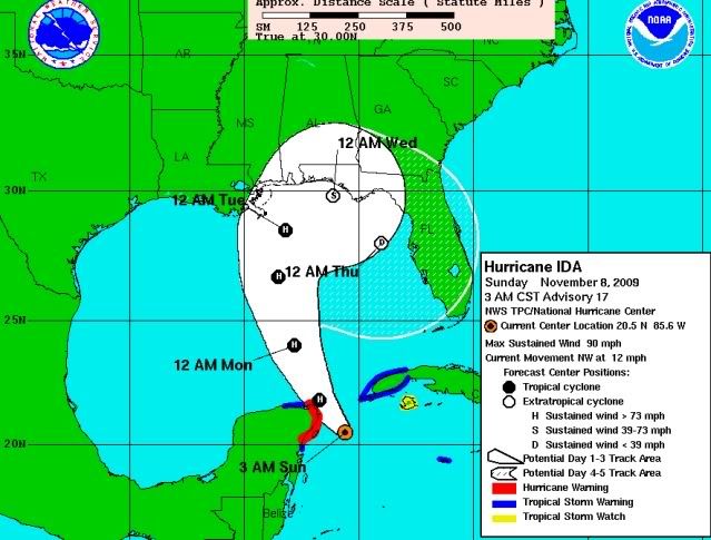
ozonepete wrote:They really need to fix this. the point east of Fort Meyers says 12AM THURSDAY!

Image

that's the hook back to the se at the end.
0 likes   

User avatar
robbielyn
Category 5
Category 5
Posts: 1298
Joined: Wed May 07, 2003 9:45 am
Location: brooksville, fl

#2562 Postby robbielyn » Sun Nov 08, 2009 5:47 am

I just carefully look at wv and that eye has stopped going nw it even look a tad ne and the eye is east of the projected track. And my eyes are wide awake as i slept all night and getting ready to work. This is the time to throw the models out the window and concentrate on what the storm is actually doing and looking at the synoptic setup. dry air will quickly entrain this system and shear it. no way it'll stay hurricane strength all the way to the north coast.
0 likes   
Robbielyn McCrary
I know just about enough to sound like I know what I'm talking about sometimes. But for your safety please follow the nhc for truly professional forecasting. :D

User avatar
KWT
Category 5
Category 5
Posts: 31415
Joined: Tue Aug 17, 2004 11:02 am
Location: UK!!!

#2563 Postby KWT » Sun Nov 08, 2009 6:05 am

Yep a cat-2, just like Irene once again, I think the system will probably struggle to get any stronger with its current structure but we shall see...still Ida is a pretty decent late season hurricane regardless!
0 likes   
Personal Forecast Disclaimer:
The posts in this forum are NOT official forecast and should not be used as such. They are just the opinion of the poster and may or may not be backed by sound meteorological data. They are NOT endorsed by any professional institution or storm2k.org. For official information, please refer to the NHC and NWS products

User avatar
cycloneye
Admin
Admin
Posts: 145619
Age: 68
Joined: Thu Oct 10, 2002 10:54 am
Location: San Juan, Puerto Rico

Re: ATL : HURRICANE IDA

#2564 Postby cycloneye » Sun Nov 08, 2009 6:07 am

Good morning to all after only 4 hours of sleep :) A long day today tracking Ida is instore.Here is the Cancun radar at 5:47 AM EST.Nice eye and eyewall.

Image
0 likes   
Visit the Caribbean-Central America Weather Thread where you can find at first post web cams,radars
and observations from Caribbean basin members Click Here

User avatar
KWT
Category 5
Category 5
Posts: 31415
Joined: Tue Aug 17, 2004 11:02 am
Location: UK!!!

#2565 Postby KWT » Sun Nov 08, 2009 6:09 am

Looking very giood on there cycloneye,wesdtertn eyewall looks pretty potent!

Didn't think I'd be tracking a hurricane in an El nino November!
0 likes   
Personal Forecast Disclaimer:
The posts in this forum are NOT official forecast and should not be used as such. They are just the opinion of the poster and may or may not be backed by sound meteorological data. They are NOT endorsed by any professional institution or storm2k.org. For official information, please refer to the NHC and NWS products

User avatar
Nimbus
Category 5
Category 5
Posts: 5305
Joined: Mon Jul 19, 2004 10:54 am

Re: ATL : HURRICANE IDA - Models

#2566 Postby Nimbus » Sun Nov 08, 2009 6:14 am

So it looks like the models all think Ida will roll up into a building ridge over the southeast and stalls?
If the ridge builds in west or southwest Ida stays out over the gulf and weakens as she churns.
0 likes   

xironman
S2K Supporter
S2K Supporter
Posts: 2522
Joined: Sun Jun 10, 2007 4:53 pm
Location: NoVA

Re: ATL : HURRICANE IDA

#2567 Postby xironman » Sun Nov 08, 2009 6:27 am

Still looks like things will quite down as Ida comes into the northern gulf

Image
0 likes   

User avatar
KWT
Category 5
Category 5
Posts: 31415
Joined: Tue Aug 17, 2004 11:02 am
Location: UK!!!

#2568 Postby KWT » Sun Nov 08, 2009 6:32 am

Hmmm thats got to be a worry, looks like the lower shear follows Ida's path exactly there. That would buy Ida an awful lot longedr before the cooler shelf waters finally weaken it.

Looks like with lower shear the peak could yet happen in the southern gulf.
0 likes   
Personal Forecast Disclaimer:
The posts in this forum are NOT official forecast and should not be used as such. They are just the opinion of the poster and may or may not be backed by sound meteorological data. They are NOT endorsed by any professional institution or storm2k.org. For official information, please refer to the NHC and NWS products

User avatar
cycloneye
Admin
Admin
Posts: 145619
Age: 68
Joined: Thu Oct 10, 2002 10:54 am
Location: San Juan, Puerto Rico

Re: ATL : HURRICANE IDA - Models

#2569 Postby cycloneye » Sun Nov 08, 2009 6:35 am

06z HWRF has landfall at Panhandle as a cat 2.

http://moe.met.fsu.edu/cgi-bin/hwrftc2. ... =Animation

Image
0 likes   
Visit the Caribbean-Central America Weather Thread where you can find at first post web cams,radars
and observations from Caribbean basin members Click Here

User avatar
Kingarabian
S2K Supporter
S2K Supporter
Posts: 16017
Joined: Sat Aug 08, 2009 3:06 am
Location: Honolulu, Hawaii

#2570 Postby Kingarabian » Sun Nov 08, 2009 6:38 am

Image

Looks like a one mess of a storm...
0 likes   
RIP Kobe Bryant

User avatar
cycloneye
Admin
Admin
Posts: 145619
Age: 68
Joined: Thu Oct 10, 2002 10:54 am
Location: San Juan, Puerto Rico

Re: ATL : HURRICANE IDA - Models

#2571 Postby cycloneye » Sun Nov 08, 2009 6:38 am

06z GFDL landfall is near Mobile as a cat 2

http://moe.met.fsu.edu/cgi-bin/gfdltc2. ... =Animation

Image
0 likes   
Visit the Caribbean-Central America Weather Thread where you can find at first post web cams,radars
and observations from Caribbean basin members Click Here

User avatar
KWT
Category 5
Category 5
Posts: 31415
Joined: Tue Aug 17, 2004 11:02 am
Location: UK!!!

#2572 Postby KWT » Sun Nov 08, 2009 6:39 am

Its got the same compact ball of convection that Irene had when it was in the SE gulf.
0 likes   
Personal Forecast Disclaimer:
The posts in this forum are NOT official forecast and should not be used as such. They are just the opinion of the poster and may or may not be backed by sound meteorological data. They are NOT endorsed by any professional institution or storm2k.org. For official information, please refer to the NHC and NWS products

O Town
S2K Supporter
S2K Supporter
Posts: 5205
Age: 52
Joined: Wed Sep 07, 2005 9:37 pm
Location: Orlando, Florida 28°35'35"N 81°22'55"W

#2573 Postby O Town » Sun Nov 08, 2009 6:40 am

And she has a sad face. :uarrow: LOL
0 likes   

#ORLANDOSTRONG

User avatar
Nimbus
Category 5
Category 5
Posts: 5305
Joined: Mon Jul 19, 2004 10:54 am

#2574 Postby Nimbus » Sun Nov 08, 2009 6:41 am

The moisture content over the gulf is ample for development but the sea surface temperatures are pretty marginal where Ida is expected to stall. It will be an interesting storm to track.
0 likes   

User avatar
KWT
Category 5
Category 5
Posts: 31415
Joined: Tue Aug 17, 2004 11:02 am
Location: UK!!!

Re:

#2575 Postby KWT » Sun Nov 08, 2009 6:45 am

O Town wrote:And she has a sad face. :uarrow: LOL


Thinking what it could have been if it hadn't hit land!

Anyway as Numbus has said this will be an interesting few days, 2009 has been a good season with regards to landfalling systems, lets hope Ida doesn't mess that all up.
0 likes   
Personal Forecast Disclaimer:
The posts in this forum are NOT official forecast and should not be used as such. They are just the opinion of the poster and may or may not be backed by sound meteorological data. They are NOT endorsed by any professional institution or storm2k.org. For official information, please refer to the NHC and NWS products

ocala
Tropical Depression
Tropical Depression
Posts: 88
Joined: Sat Apr 08, 2006 8:48 am
Location: Candler,Florida
Contact:

Re:

#2576 Postby ocala » Sun Nov 08, 2009 6:46 am

O Town wrote:And she has a sad face. :uarrow: LOL


That's funny. I didn't know what you meant by that until I looked at the image.


..Summary of 600 am CST information...
location...20.8n 85.7w
maximum sustained winds...90 mph
present movement...northwest or 325 degrees at 12 mph
minimum central pressure...983 mb
0 likes   

User avatar
cycloneye
Admin
Admin
Posts: 145619
Age: 68
Joined: Thu Oct 10, 2002 10:54 am
Location: San Juan, Puerto Rico

Re: ATL : HURRICANE IDA - Advisories

#2577 Postby cycloneye » Sun Nov 08, 2009 6:48 am

000
WTNT31 KNHC 081143
TCPAT1
BULLETIN
HURRICANE IDA INTERMEDIATE ADVISORY NUMBER 17A
NWS TPC/NATIONAL HURRICANE CENTER MIAMI FL AL112009
600 AM CST SUN NOV 08 2009

...IDA APPROACHING THE NORTHEASTERN TIP OF THE YUCATAN PENINSULA...

A HURRICANE WARNING REMAINS IN EFFECT FOR THE YUCATAN PENINSULA OF
MEXICO FROM PLAYA DEL CARMEN TO CABO CATOCHE. A HURRICANE WARNING
MEANS THAT HURRICANE CONDITIONS ARE EXPECTED SOMEWHERE WITHIN THE
WARNING AREA WITHIN 24 HOURS. PREPARATIONS TO PROTECT LIFE AND
PROPERTY SHOULD BE RUSHED TO COMPLETION IN THE WARNING AREA.

A HURRICANE WATCH REMAINS IN EFFECT FOR THE YUCATAN PENINSULA OF
MEXICO FROM TULUM TO PLAYA DEL CARMEN. A HURRICANE WATCH MEANS THAT
HURRICANE CONDITIONS ARE POSSIBLE WITHIN THE WATCH AREA.

A TROPICAL STORM WARNING REMAINS IN EFFECT FOR THE YUCATAN PENINSULA
OF MEXICO FROM PUNTA ALLEN NORTHWARD TO PLAYA DEL CARMEN AND FROM
CABO CATOCHE WESTWARD TO SAN FELIPE. A TROPICAL STORM WARNING
MEANS THAT TROPICAL STORM CONDITIONS ARE EXPECTED WITHIN THE
WARNING AREA WITHIN 24 HOURS.

A TROPICAL STORM WARNING REMAINS IN EFFECT FOR THE CUBAN PROVINCE OF
PINAR DEL RIO.

A TROPICAL STORM WATCH REMAINS IN EFFECT FOR THE ISLE OF YOUTH.

AT 600 AM CST...1200 UTC...THE TROPICAL STORM WARNING FOR GRAND
CAYMAN ISLAND IS DISCONTINUED.

FOR STORM INFORMATION SPECIFIC TO YOUR AREA IN THE UNITED
STATES...INCLUDING POSSIBLE MARINE AND COASTAL FLOOD WATCHES AND
WARNINGS...PLEASE MONITOR PRODUCTS ISSUED BY YOUR LOCAL NATIONAL
WEATHER SERVICE FORECAST OFFICE.

FOR STORM INFORMATION SPECIFIC TO YOUR AREA OUTSIDE OF THE UNITED
STATES...PLEASE MONITOR PRODUCTS ISSUED BY YOUR NATIONAL
METEOROLOGICAL SERVICE.

AT 600 AM CST...1200 UTC...THE CENTER OF HURRICANE IDA WAS LOCATED
NEAR LATITUDE 20.8 NORTH...LONGITUDE 85.7 WEST OR ABOUT 70 MILES...
115 KM...EAST-NORTHEAST OF COZUMEL MEXICO AND ABOUT 85 MILES...
135 KM...SOUTH-SOUTHWEST OF THE WESTERN TIP OF CUBA.

IDA IS MOVING TOWARD THE NORTHWEST NEAR 12 MPH...19 KM/HR. A TURN
TOWARD THE NORTH-NORTHWEST AND THEN NORTH IS EXPECTED OVER THE NEXT
COUPLE OF DAYS WITH AN INCREASE IN FORWARD SPEED. ON THE FORECAST
TRACK...IDA IS EXPECTED TO MOVE THROUGH THE YUCATAN CHANNEL AND
INTO THE SOUTHEASTERN GULF OF MEXICO LATER TODAY...PASSING CLOSE TO
THE NORTHEASTERN TIP OF THE YUCATAN PENINSULA.

MAXIMUM SUSTAINED WINDS ARE NEAR 90 MPH...150 KM/HR...WITH HIGHER
GUSTS. IDA IS A CATEGORY ONE HURRICANE ON THE SAFFIR-SIMPSON SCALE.
SOME STRENGTHENING IS FORECAST...AND IDA COULD BECOME A CATEGORY TWO
HURRICANE TODAY OR TONIGHT. GRADUAL WEAKENING IS EXPECTED TO BEGIN
BY LATE MONDAY.

HURRICANE FORCE WINDS EXTEND OUTWARD UP TO 15 MILES...30 KM...FROM
THE CENTER...AND TROPICAL STORM FORCE WINDS EXTEND OUTWARD UP TO
140 MILES...220 KM.

THE LATEST MINIMUM CENTRAL PRESSURE MEASURED BY AN AIR FORCE
RESERVER HURRICANE HUNTER AIRCRAFT WAS 983 MB...29.03 INCHES.

IDA IS EXPECTED TO PRODUCE TOTAL RAIN ACCUMULATIONS OF 3 TO 5 INCHES
OVER PORTIONS OF THE YUCATAN PENINSULA AND WESTERN CUBA...WITH
POSSIBLE ISOLATED MAXIMUM AMOUNTS OF 10 INCHES.

A STORM SURGE COULD RAISE WATER LEVELS BY AS MUCH AS 3 TO 4 FEET
ABOVE GROUND LEVEL ALONG THE COAST OF THE YUCATAN PENINSULA...WITH
LARGE AND DANGEROUS BATTERING WAVES.

...SUMMARY OF 600 AM CST INFORMATION...
LOCATION...20.8N 85.7W
MAXIMUM SUSTAINED WINDS...90 MPH
PRESENT MOVEMENT...NORTHWEST OR 325 DEGREES AT 12 MPH
MINIMUM CENTRAL PRESSURE...983 MB

THE NEXT ADVISORY WILL BE ISSUED BY THE NATIONAL HURRICANE CENTER AT
900 AM CST.

$$
FORECASTER BEVEN/ROBERTS
0 likes   
Visit the Caribbean-Central America Weather Thread where you can find at first post web cams,radars
and observations from Caribbean basin members Click Here

jinftl
Category 5
Category 5
Posts: 4312
Joined: Tue Aug 31, 2004 4:47 pm
Location: fort lauderdale, fl

Re: ATL : HURRICANE IDA

#2578 Postby jinftl » Sun Nov 08, 2009 7:13 am

Please forgive the quality of the photo i took (with cell phone), but i can confirm the satellite image below...the outermost cirrus stream from Ida is moving over southeast florida this morning.....made for a beautiful sunrise when mixed with the cotton ball clouds streaming in from the ocean on 30 mph winds...

Image

Image
0 likes   

User avatar
alan1961
Category 2
Category 2
Posts: 771
Joined: Mon Mar 20, 2006 11:58 am
Location: Derby, Derbyshire, England
Contact:

Re: ATL : HURRICANE IDA

#2579 Postby alan1961 » Sun Nov 08, 2009 7:31 am

Last edited by alan1961 on Sun Nov 08, 2009 7:34 am, edited 1 time in total.
0 likes   

User avatar
Recurve
Category 5
Category 5
Posts: 1640
Joined: Tue Aug 16, 2005 8:59 pm
Location: St. Petersburg, FL

Re: ATL : HURRICANE IDA

#2580 Postby Recurve » Sun Nov 08, 2009 7:34 am

Yes indeed, the fringes of Ida here. Winds off Key West sustained at 37 knots.

http://www.ndbc.noaa.gov/station_page.php?station=sanf1
0 likes   


Return to “2009”

Who is online

Users browsing this forum: No registered users and 188 guests