ATL : TROPICAL DEPRESSION IDA

Moderator: S2k Moderators

Message
Author
Dean4Storms
S2K Supporter
S2K Supporter
Posts: 6358
Age: 62
Joined: Sun Aug 31, 2003 1:01 pm
Location: Miramar Bch. FL

Re:

#2701 Postby Dean4Storms » Sun Nov 08, 2009 11:23 am

DESTRUCTION5 wrote:12z going more conventional with a Panhandle landfall and turning her in to a MONSTER Noreaster rater than the dive SE....

http://www.nco.ncep.noaa.gov/pmb/nwprod ... n_072l.gif
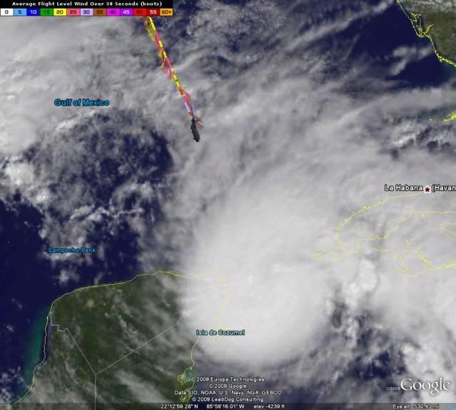


Yep, my concern is growing by the hour!
0 likes   

User avatar
Hurricanewatcher2007
Category 2
Category 2
Posts: 578
Joined: Sat Jul 05, 2008 8:10 pm

Re: Re:

#2702 Postby Hurricanewatcher2007 » Sun Nov 08, 2009 11:23 am

cycloneye wrote:
deltadog03 wrote:I find it interesting that recon is flying at 400mb level right now on there way to IDA and in there obs there are indicating that the winds are only 23kt at that level. Not too bad right now over the northern gom.


Winds increasing in the central gulf.

160200 2516N 08747W 3928 07683 0371 -177 -225 117041 043 031 000 00
160230 2514N 08746W 3925 07691 0369 -181 -225 122039 041 032 000 00
160300 2512N 08745W 3926 07674 0372 -180 -225 137038 039 031 000 00
$$


yes winds are increasing but looks like it mostly has to do with Ida's outflow which will be moving with Ida.
0 likes   

User avatar
cycloneye
Admin
Admin
Posts: 145568
Age: 68
Joined: Thu Oct 10, 2002 10:54 am
Location: San Juan, Puerto Rico

Re: ATL : HURRICANE IDA - Recon=Plane is flying towards Ida

#2703 Postby cycloneye » Sun Nov 08, 2009 11:23 am

Dropsonde

Product: Air Force Temp Drop (Dropsonde) Message (UZNT13 KNHC)
Transmitted: 8th day of the month at 16:16Z
Aircraft: Air Force Aircraft (Last 3 digits of the tail number are 309)
Storm Number: 11
Storm Name: Ida (flight in the North Atlantic basin)
Mission Number: 4
Observation Number: 02

Date: Near the closest hour of 16Z on the 8th day of the month
Highest Mandatory Level For Which Wind Was Reported: 500mb
Coordinates: 27.6N 88.9W
Location: 179 miles (287 km) to the SSE (157°) from New Orleans, LA, USA.
Marsden Square: 081 (About)
0 likes   
Visit the Caribbean-Central America Weather Thread where you can find at first post web cams,radars
and observations from Caribbean basin members Click Here

Aric Dunn
Category 5
Category 5
Posts: 21238
Age: 42
Joined: Sun Sep 19, 2004 9:58 pm
Location: Ready for the Chase.
Contact:

Re: ATL : HURRICANE IDA

#2704 Postby Aric Dunn » Sun Nov 08, 2009 11:25 am

shear continues to drop rather fast almost to the gulf coast..

would not be surprised to have a fully tropical system making landfall ...

present:
Image

12 hours ago:
Image
0 likes   

User avatar
cycloneye
Admin
Admin
Posts: 145568
Age: 68
Joined: Thu Oct 10, 2002 10:54 am
Location: San Juan, Puerto Rico

Re: ATL : HURRICANE IDA - Recon=Plane is flying towards Ida

#2705 Postby cycloneye » Sun Nov 08, 2009 11:27 am

OB 11

000
URNT15 KNHC 081621
AF309 0411A IDA HDOB 11 20091108
161330 2431N 08726W 3927 07712 0394 -170 -215 117027 029 032 006 00
161400 2429N 08725W 3927 07705 0395 -167 -214 117021 021 029 001 00
161430 2427N 08724W 3924 07715 0396 -168 -213 121023 024 027 001 00
161500 2425N 08723W 3926 07709 0396 -171 -213 119025 025 026 000 00
161530 2423N 08723W 3919 07722 0395 -175 -214 122025 025 025 000 00
161600 2421N 08722W 3925 07719 0398 -175 -214 120026 026 024 001 03
161630 2419N 08722W 3929 07699 0394 -177 -216 111025 026 028 000 03
161700 2417N 08724W 3930 07702 0392 -173 -218 107023 025 027 001 00
161730 2415N 08725W 3927 07706 0393 -170 -221 109021 021 027 000 00
161800 2413N 08726W 3926 07710 0393 -169 -223 115023 023 028 001 00
161830 2411N 08727W 3927 07704 0393 -167 -225 117022 023 027 000 00
161900 2409N 08729W 3927 07709 0394 -166 -227 114020 021 028 000 00
161930 2409N 08729W 3927 07709 0394 -165 -228 112018 018 027 000 00
162000 2405N 08731W 3925 07715 0395 -165 -229 113015 017 027 000 00
162030 2403N 08733W 3927 07710 0394 -165 -230 110015 016 027 000 00
162100 2401N 08734W 3926 07712 0395 -166 -230 109014 015 026 000 00
162130 2359N 08735W 3926 07710 0394 -167 -230 108010 012 027 000 00
162200 2357N 08736W 3926 07705 0393 -170 -229 116009 009 028 000 00
162230 2355N 08738W 3926 07705 0392 -170 -229 122008 008 028 000 00
162300 2353N 08739W 3925 07713 0393 -170 -229 122009 009 028 001 00
0 likes   
Visit the Caribbean-Central America Weather Thread where you can find at first post web cams,radars
and observations from Caribbean basin members Click Here

xironman
S2K Supporter
S2K Supporter
Posts: 2522
Joined: Sun Jun 10, 2007 4:53 pm
Location: NoVA

Re: ATL : HURRICANE IDA

#2706 Postby xironman » Sun Nov 08, 2009 11:27 am

Aric Dunn wrote:shear continues to drop rather fast almost to the gulf coast..

That is what the models said would happen.
0 likes   

User avatar
Ivanhater
Storm2k Moderator
Storm2k Moderator
Posts: 11162
Age: 38
Joined: Fri Jul 01, 2005 8:25 am
Location: Pensacola

Re: ATL : HURRICANE IDA

#2707 Postby Ivanhater » Sun Nov 08, 2009 11:29 am

I noticed the Hurricane watch only extends to the MS/AL border. Is that supposed to extend east as it gets closer cause landfall is still showing the Pensacola area?
0 likes   
Michael

User avatar
wxman57
Moderator-Pro Met
Moderator-Pro Met
Posts: 22984
Age: 67
Joined: Sat Jun 21, 2003 8:06 pm
Location: Houston, TX (southwest)

Re: ATL : HURRICANE IDA

#2708 Postby wxman57 » Sun Nov 08, 2009 11:29 am

New GFS dropped the goofy E-SE hook and accelerates the merged Ida-frontal low NE across Alabama and Georgia on Tuesday. Since it agrees with my track, I agree with the GFS. ;-)
0 likes   

tampastorm
Category 1
Category 1
Posts: 434
Joined: Thu Aug 12, 2004 9:22 pm
Location: TAMPA

#2709 Postby tampastorm » Sun Nov 08, 2009 11:30 am

Could someone post a map of the front/trough and where it is that suppose to influence IDA?
0 likes   

curtadams
S2K Supporter
S2K Supporter
Posts: 1122
Joined: Sun Aug 28, 2005 7:57 pm
Location: Orange, California
Contact:

#2710 Postby curtadams » Sun Nov 08, 2009 11:31 am

I can think of another reason for hurricane warnings only for LA and MS. For Ida to landfall as a hurricane the front will probably have to slow or weaken - meaning Ida will move more W as well. If Ida gets smacked over to the Panhandle by 40 kt shear she's very unlikely to be a hurricane or even tropical - so much less likelihood of a hurricane strike and no warning.
0 likes   

User avatar
HURAKAN
Professional-Met
Professional-Met
Posts: 46086
Age: 38
Joined: Thu May 20, 2004 4:34 pm
Location: Key West, FL
Contact:

#2711 Postby HURAKAN » Sun Nov 08, 2009 11:32 am

Image
0 likes   

User avatar
HURAKAN
Professional-Met
Professional-Met
Posts: 46086
Age: 38
Joined: Thu May 20, 2004 4:34 pm
Location: Key West, FL
Contact:

#2712 Postby HURAKAN » Sun Nov 08, 2009 11:32 am

Image
0 likes   

User avatar
HURAKAN
Professional-Met
Professional-Met
Posts: 46086
Age: 38
Joined: Thu May 20, 2004 4:34 pm
Location: Key West, FL
Contact:

#2713 Postby HURAKAN » Sun Nov 08, 2009 11:33 am

Image

Closer to Ida
0 likes   

User avatar
cycloneye
Admin
Admin
Posts: 145568
Age: 68
Joined: Thu Oct 10, 2002 10:54 am
Location: San Juan, Puerto Rico

Re: ATL : HURRICANE IDA - Recon=Plane is flying towards Ida

#2714 Postby cycloneye » Sun Nov 08, 2009 11:36 am

OB 12=Plane decends

URNT15 KNHC 081631
AF309 0411A IDA HDOB 12 20091108
162330 2351N 08740W 3925 07710 0392 -171 -230 123008 008 029 000 00
162400 2349N 08741W 3925 07710 0391 -172 -230 126009 009 029 001 00
162430 2347N 08743W 3928 07703 0391 -169 -231 125010 010 028 000 00
162500 2345N 08744W 3926 07704 0391 -170 -232 120009 010 028 000 00
162530 2343N 08745W 3958 07644 0386 -167 -233 116010 011 028 000 00
162600 2341N 08747W 4042 07486 0374 -156 -232 121007 008 027 000 00
162630 2339N 08748W 4098 07381 0367 -148 -232 110004 005 026 001 00
162700 2337N 08749W 4160 07262 0362 -141 -231 132006 008 025 000 00
162730 2334N 08751W 4244 07117 0354 -127 -231 115013 014 024 001 03
162800 2332N 08751W 4328 06967 0342 -126 -228 110009 011 026 000 00
162830 2330N 08752W 4417 06810 0333 -113 -224 103009 009 026 002 00
162900 2327N 08753W 4544 06599 0326 -100 -223 083014 017 027 002 00
162930 2325N 08753W 4682 06371 0315 -085 -217 092013 015 027 001 03
163000 2323N 08754W 4899 06023 0300 -067 -210 082010 011 025 000 03
163030 2321N 08755W 5098 05709 0280 -053 -203 076012 012 026 000 00
163100 2319N 08756W 5296 05407 0262 -036 -194 071013 014 028 001 03
163130 2317N 08758W 5497 05111 0243 -018 -185 062014 014 028 001 00
163200 2316N 08800W 5703 04810 0078 +001 -174 058014 014 029 000 00
163230 2314N 08802W 5902 04520 0073 +012 -162 069020 023 030 001 00
163300 2313N 08804W 6087 04296 0113 +021 -150 078022 023 024 000 00
$$
0 likes   
Visit the Caribbean-Central America Weather Thread where you can find at first post web cams,radars
and observations from Caribbean basin members Click Here

User avatar
HURAKAN
Professional-Met
Professional-Met
Posts: 46086
Age: 38
Joined: Thu May 20, 2004 4:34 pm
Location: Key West, FL
Contact:

#2715 Postby HURAKAN » Sun Nov 08, 2009 11:37 am

Image

Looking good
0 likes   

Aric Dunn
Category 5
Category 5
Posts: 21238
Age: 42
Joined: Sun Sep 19, 2004 9:58 pm
Location: Ready for the Chase.
Contact:

Re:

#2716 Postby Aric Dunn » Sun Nov 08, 2009 11:37 am

curtadams wrote:I can think of another reason for hurricane warnings only for LA and MS. For Ida to landfall as a hurricane the front will probably have to slow or weaken - meaning Ida will move more W as well. If Ida gets smacked over to the Panhandle by 40 kt shear she's very unlikely to be a hurricane or even tropical - so much less likelihood of a hurricane strike and no warning.


The shear is decreasing and will continue too as the there is a small upper low to its Sw that has been moving north with it for the last two days putting it the environment it has been in.. gfdl and hwrf both see this feature staying with hence the stronger system.. transition is not likely before landfall .. but hey im ready to see people back pedaling ( including my self of course)
0 likes   

User avatar
cycloneye
Admin
Admin
Posts: 145568
Age: 68
Joined: Thu Oct 10, 2002 10:54 am
Location: San Juan, Puerto Rico

Re: ATL : HURRICANE IDA

#2717 Postby cycloneye » Sun Nov 08, 2009 11:37 am

Plane starts to decend.
0 likes   
Visit the Caribbean-Central America Weather Thread where you can find at first post web cams,radars
and observations from Caribbean basin members Click Here

User avatar
Ivanhater
Storm2k Moderator
Storm2k Moderator
Posts: 11162
Age: 38
Joined: Fri Jul 01, 2005 8:25 am
Location: Pensacola

Re: ATL : HURRICANE IDA

#2718 Postby Ivanhater » Sun Nov 08, 2009 11:37 am

Ivanhater wrote:I noticed the Hurricane watch only extends to the MS/AL border. Is that supposed to extend east as it gets closer cause landfall is still showing the Pensacola area?


Anybody know? lol
0 likes   
Michael

Aric Dunn
Category 5
Category 5
Posts: 21238
Age: 42
Joined: Sun Sep 19, 2004 9:58 pm
Location: Ready for the Chase.
Contact:

Re:

#2719 Postby Aric Dunn » Sun Nov 08, 2009 11:38 am

HURAKAN wrote:Image

Closer to Ida

awesome i love that picture better :)
0 likes   

Aric Dunn
Category 5
Category 5
Posts: 21238
Age: 42
Joined: Sun Sep 19, 2004 9:58 pm
Location: Ready for the Chase.
Contact:

Re: ATL : HURRICANE IDA

#2720 Postby Aric Dunn » Sun Nov 08, 2009 11:38 am

Ivanhater wrote:
Ivanhater wrote:I noticed the Hurricane watch only extends to the MS/AL border. Is that supposed to extend east as it gets closer cause landfall is still showing the Pensacola area?


Anybody know? lol

I t should be farther east but who knows what the nhc is thinking..
0 likes   


Return to “2009”

Who is online

Users browsing this forum: No registered users and 8 guests