...SUMMARY OF 800 AM AST INFORMATION...
LOCATION...16.5N 59.5W
MAXIMUM SUSTAINED WINDS...45 MPH
PRESENT MOVEMENT...WEST OR 270 DEGREES AT 7 MPH
MINIMUM CENTRAL PRESSURE...1008 MB
ATL : TROPICAL DEPRESSION ERIKA (06L)
Moderator: S2k Moderators
-
dekeoy
- Tropical Depression

- Posts: 53
- Joined: Mon Aug 02, 2004 7:42 pm
- Location: Wilmington/Wrightsville Beach, NC
- Contact:
Re: ATL : TROPICAL STORM ERIKA (06L)
seems she's got our NWS office's attention to a point.
AREA FORECAST DISCUSSION
NATIONAL WEATHER SERVICE WILMINGTON NC
742 AM EDT WED SEP 2 2009
.LONG TERM /SATURDAY THROUGH TUESDAY/...
AS OF 3 AM WEDNESDAY...THE MID LEVEL FLOW REMAINS FROM THE SOUTHWEST
THROUGHOUT THE PERIOD WHICH GENERALLY MEANS A MOIST AND UNSETTLED
FLOW. HOWEVER...A SECOND ROUND OF STRONG WEDGING IS BEING
ADVERTISED BY THE GFS FOR LATE SUNDAY INTO MONDAY AS MID LEVEL
CONFLUENCE STRENGTHENS OVER THE NORTHEAST. OVERALL...HAVE TRENDED
DOWN ON THE POPS A BIT FOR SUNDAY INTO MONDAY VIA THE DRY SURFACE
HIGH BUILDING IN ONCE AGAIN...WITH NO OTHER CHANGES. TEMPERATURE
TRENDS LOOK GOOD WITH A BRIEF RETURN TO SEASONAL VALUES SATURDAY
INTO SUNDAY TRENDING DOWN ONCE AGAIN EARLY NEXT WEEK. IT APPEARS
AT THIS POINT TROPICAL STORM ERIKA...WITH HER SLOW MOVEMENT...WILL
NOT BE AN IMMEDIATE CONCERN THROUGH THIS TIME FRAME.
0 likes


-
HURAKAN

- Professional-Met

- Posts: 46084
- Age: 39
- Joined: Thu May 20, 2004 4:34 pm
- Location: Key West, FL
- Contact:
999
URNT15 KNHC 021155
AF305 0206A ERIKA HDOB 50 20090902
114500 1656N 06101W 8429 01577 0100 +174 +174 077030 031 999 999 03
114530 1657N 06103W 8429 01579 0099 +178 +178 074032 032 999 999 03
114600 1658N 06106W 8431 01578 0101 +176 +176 071033 034 999 999 03
114630 1659N 06108W 8429 01582 0106 +175 +175 070033 034 999 999 03
114700 1659N 06110W 8431 01584 0107 +176 +176 069033 034 999 999 03
114730 1700N 06113W 8429 01587 0110 +174 +174 069033 034 999 999 03
114800 1701N 06115W 8430 01588 0112 +175 +175 067034 034 999 999 03
114830 1702N 06118W 8429 01589 0114 +173 +173 062038 040 999 999 03
114900 1703N 06120W 8429 01589 0114 +172 +172 064041 041 999 999 05
114930 1704N 06123W 8429 01589 0113 +172 +172 065040 041 999 999 05
115000 1704N 06125W 8429 01591 9990 +171 +999 064040 040 036 000 05
115030 1705N 06128W 8429 01593 0117 +173 +173 055034 036 034 000 01
115100 1706N 06130W 8425 01587 0097 +175 +175 052032 032 026 001 03
115130 1706N 06132W 7682 02366 9990 +146 +999 053033 034 999 999 05
115200 1706N 06134W 7304 02796 9990 +132 +999 035027 028 999 999 05
115230 1706N 06136W 6907 03267 9990 +111 +999 024023 024 999 999 05
115300 1707N 06138W 6541 03723 9990 +082 +999 029022 022 999 999 05
115330 1707N 06140W 6300 04035 9990 +059 +999 041021 022 999 999 05
115400 1707N 06142W 6065 04345 9990 +038 +999 059018 020 999 999 05
115430 1707N 06144W 5802 04700 9990 +023 +999 039017 019 999 999 05
$$
;
Ascending and leaving
0 likes
-
Evil Jeremy

- S2K Supporter

- Posts: 5463
- Age: 32
- Joined: Mon Apr 10, 2006 2:10 pm
- Location: Los Angeles, CA
Re: ATL : TROPICAL STORM ERIKA (06L)
Its really interesting to look at the forecast cone updated with the 8AM info. Erika would have to move NNW from here on out to make the next point, and its still headed west lol:

0 likes
-
Gustywind

- Category 5

- Posts: 12334
- Joined: Mon Sep 03, 2007 7:29 am
- Location: Baie-Mahault, GUADELOUPE
Here we are in Guadeloupe: Meteo-France has just issued an yellow alert for Guadeloupe and there's higher chances to pass in orange alert before the end of the day. They have Erika at 17,0 N 59,6W, a little more west compared to the NHC (17N 59W)but they said that it's an approximative center. Waves are expected tonight to be near 4 meters , but the strong showers and tstorms should affect us tommrow, gusts could reach 40kts and a little more. The risk to see Erika at cane status are weak...Guadeloupe should deal with a the effects of a TS with a moderate to strong impact.
The heart of this storm shoud pass on Guadeloupe tonight but especially tommorow.
I will give you more later as the next update will be at 12AM.
Gustywind
The heart of this storm shoud pass on Guadeloupe tonight but especially tommorow.
I will give you more later as the next update will be at 12AM.
Gustywind
0 likes

Re: ATL : TROPICAL STORM ERIKA (06L)
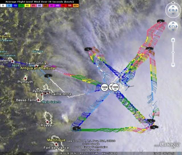
Probably more than 1 center and a good bit farther south than it should be. Check out the above  radar and you see a vortex moving SSW and the larger broader circulation.
0 likes
-
Gustywind
- Category 5
- Posts: 12334
- Joined: Mon Sep 03, 2007 7:29 am
- Location: Baie-Mahault, GUADELOUPE
Re:
HURAKAN wrote:...SUMMARY OF 800 AM AST INFORMATION...
LOCATION...16.5N 59.5W
MAXIMUM SUSTAINED WINDS...45 MPH
PRESENT MOVEMENT...WEST OR 270 DEGREES AT 7 MPH
MINIMUM CENTRAL PRESSURE...1008 MB
What is that? the Latest forecast of the NHC at 8AM i guess or not???
Link please...Erika churning near Guadeloupe?!
0 likes

good morning
It's looks like St Maarten is under the gun too.
Using stormcarib.com how close can it get, using current forecast positions, the results for st. maarten are :
Results for St.Maarten/St.Martin (18.05N, 63.12W): The approximate Closest Point of Approach (CPA) is located near 18.4N, 63.0W or about 27.9 miles (44.9 km) from your location. The estimated time of when the center of the storm will be at that location is in about 36.4 hours (Thursday, September 3 at 5:24PM
Like Luis, I am concerned about the flooding possibilities. Even a heavy thunderstorm can give us minor flooding.
Barbara
0 likes
-
HURAKAN
- Professional-Met
- Posts: 46084
- Age: 39
- Joined: Thu May 20, 2004 4:34 pm
- Location: Key West, FL
- Contact:
Re: Re:
Gustywind wrote:HURAKAN wrote:...SUMMARY OF 800 AM AST INFORMATION...
LOCATION...16.5N 59.5W
MAXIMUM SUSTAINED WINDS...45 MPH
PRESENT MOVEMENT...WEST OR 270 DEGREES AT 7 MPH
MINIMUM CENTRAL PRESSURE...1008 MB
What is that? the Latest forecast of the NHC at 8AM i guess or not???

Link please...Erika churning near Guadeloupe?!
Summary of the 8 am intermediate advisory
http://www.nhc.noaa.gov/text/refresh/MI ... 1150.shtml
0 likes

-
Evil Jeremy
- S2K Supporter
- Posts: 5463
- Age: 32
- Joined: Mon Apr 10, 2006 2:10 pm
- Location: Los Angeles, CA
Re:
HURAKAN wrote:
Convection appears to be bursting over the LLC
Which LLC lol? How many are there?
0 likes
-
BatzVI

- Tropical Storm

- Posts: 199
- Joined: Sat Jun 10, 2006 8:27 am
- Location: St. Thomas, Virgin Islands
Re: ATL : TROPICAL STORM ERIKA (06L)
I don't understand why they have not put us under at least a TS Watch....it's looking more obvious that the VI will be getting weather and it doesn't take much to create mudslides, etc....I guess it'll happen by 11am????
0 likes

Re: ATL : TROPICAL STORM ERIKA - Computer Models
You never know, but there my not be much left of Erika for models to track in another 24hrs, She looks very disorganized.
0 likes
-
HURAKAN
- Professional-Met
- Posts: 46084
- Age: 39
- Joined: Thu May 20, 2004 4:34 pm
- Location: Key West, FL
- Contact:
Re: ATL : TROPICAL STORM ERIKA (06L)
BatzVI wrote:I don't understand why they have not put us under at least a TS Watch....it's looking more obvious that the VI will be getting weather and it doesn't take much to create mudslides, etc....I guess it'll happen by 11am????
I'm pretty sure watches or warnings will go up by 11 AM. I guess the NHC is now calling the respective governments and getting them to put up the watches or watchings.
0 likes
Who is online
Users browsing this forum: No registered users and 19 guests