
AL, 06, 2009090212, , BEST, 0, 163N, 600W, 40, 1008, TS
Moderator: S2k Moderators

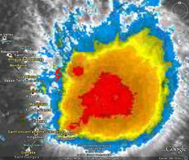
wxman57 wrote:The satellite image in this surface plot is a little old, but you can clearly see the LLC near northern Guadeloupe Island. Obs all around fit THAT as being the real center of Erika. I don't see any evidence on satellite or surface obs of a large gyre with multiple vortices now.
Have I mentioned that I hate storms like this lately?

Derek Ortt wrote:however, recon is flying at 850mb. Wonder if that vtx is not quite reaching the surface


Derek Ortt wrote:however, recon is flying at 850mb. Wonder if that vtx is not quite reaching the surface


Normandy wrote:Looking at these maps, I would say Erika is FAR from being very disorganized. Great Low Level Convergence, along with good Upper divergence and little shear will get this think cranking today. I think it went through some center reformations overnight which explains the SW motion.
http://cimss.ssec.wisc.edu/tropic/real- ... 8conv.html
http://cimss.ssec.wisc.edu/tropic/real- ... g8dvg.html
http://cimss.ssec.wisc.edu/tropic/real- ... g8shr.html

Air Force Met wrote:Derek Ortt wrote:however, recon is flying at 850mb. Wonder if that vtx is not quite reaching the surface
As I said...I'm seeing low level clouds headed into that blob...those are below 850.
Its possible...but how many times have we seen a TC with a broad circulation spit out a vort center only to spin up another one under the convection? I think that is what's happening now.
WHY its happening? can't explain. SAL...undercutting shear...who knows. All I know is it has great upper level outflow and deep deep convection. Should be going ape.
Derek Ortt wrote:could be a SAL surge. One was catching up yesterday.

xironman wrote:That little vort max shows up nicely if you animate the radar http://www.meteo.fr/temps/domtom/antilles/pack-public/animation/animMOSAIC2.html
wxman57 wrote: Yeah, you're right, we've seen weak multi-vortex systems many times. A vortex moving away from the convection can't sustain itself. Either it dies and another forms near the convection or the TS dies. But note the SE wind at 20 kts on my plot above that seems to point perpendicular to the low cloud flow into the convection. Could be a bad wind direction from that ship. I don't trust ships much.
wxman57 wrote:One major clue that the center near Guadeloupe isn't the actual real center is that it is now moving to the south. Good indication that it's rotating around another center farther east. Possibly near 16.5/59.5.
tpr1967 wrote:You never know, but there my not be much left of Erika for models to track in another 24hrs, She looks very disorganized.
wxman57 wrote:One major clue that the center near Guadeloupe isn't the actual real center is that it is now moving to the south. Good indication that it's rotating around another center farther east. Possibly near 16.5/59.5.
Evil Jeremy wrote:promets, what do you think Erika's path could be like now? Where do you see Erika in 5 days?
Users browsing this forum: No registered users and 19 guests

