
ATL: TROPICAL STORM BILL (03L)
Moderator: S2k Moderators
-
HURAKAN

- Professional-Met

- Posts: 46084
- Age: 39
- Joined: Thu May 20, 2004 4:34 pm
- Location: Key West, FL
- Contact:
000
URNT15 KNHC 200545
AF303 0303A BILL HDOB 25 20090820
053600 2146N 05901W 6963 03046 9990 +069 +999 131102 104 067 018 01
053630 2145N 05902W 6961 03040 9990 +069 +999 132099 104 066 018 01
053700 2144N 05903W 6969 03030 9990 +079 +999 132096 097 063 012 01
053730 2142N 05904W 6970 03022 9990 +083 +999 134101 104 065 010 01
053800 2141N 05905W 6967 03020 9990 +087 +999 132103 106 068 012 01
053830 2140N 05907W 6964 03020 9990 +086 +999 130100 100 070 010 01
053900 2139N 05908W 6970 03007 9990 +085 +999 132103 104 071 011 01
053930 2138N 05909W 6967 02998 9990 +088 +999 133105 107 072 012 01
054000 2137N 05910W 6964 02991 9990 +089 +999 133107 108 076 013 01
054030 2136N 05911W 6969 02982 9990 +085 +999 131108 109 076 014 01
054100 2135N 05912W 6968 02977 9990 +086 +999 128109 110 073 016 01
054130 2134N 05914W 6964 02970 9990 +085 +999 129107 110 075 016 01
054200 2132N 05915W 6966 02959 9990 +088 +999 129108 109 076 017 01
054230 2131N 05916W 6974 02938 9990 +081 +999 130112 114 077 019 01
054300 2130N 05917W 6960 02942 9990 +082 +999 130114 114 083 015 01
054330 2129N 05919W 6958 02933 9990 +089 +999 131120 121 085 011 01
054400 2128N 05920W 6970 02903 9990 +095 +999 134116 117 085 011 01
054430 2127N 05921W 6968 02891 9990 +098 +999 136118 119 084 014 01
054500 2126N 05922W 6966 02881 9990 +094 +999 135119 123 082 022 05
054530 2125N 05923W 6969 02855 9990 +093 +999 134116 117 085 035 05
$$
;
0 likes

-
DreamworksSKG
Re: ATL: HURRICANE BILL (Models)
Excuse me . people have a right to differing opinions you know and shouldn't just be torn apart by all you "Experts" out there.
You know the weather channel earlier this week predicted a hit on Bermuda...and got all the media up in arms about it. and they said east of bermuda a few days before.
I've been saying all along this was headed for the Gulf of Maine --for about a week before they did. All from watching the models and the forecasts.
So don't bash people for having a different viewpoint.
Harvey Leonard and Dick Albert worked together for awhile before Dick Retired. They'd always have different views but were still good friends. They had plenty of heated discussions over snow-storms, hurricane tracks, temperatures, etc. but always were friends. Lets try to be the same here.
I only believe Bill will move a LITTLE MORE west than the official track thinks. I think it will be closer to the Cape and Islands than they think or thought.
Yeah Bill won't hit Long Island or New York City, but until Bill clears our latitude and longitude (70) we should continue to watch it and be ready to act should it veer left just a bit.
Regardless this should be a BIG TIME wake up call for people in the Northeast and New England about how quickly a storm can threaten or change a track and get too close for comfort. We may have dodged the bullet this time. But what about next time?
Joe B says we're well overdue for a hit in New England. Hopefully this "Scare" will wake people up about stronger storms moving quickly up here.
Also its kinda funny isn't it..
Warmer than normal 70* Degree sea temps near Nova Scotia.
Could that be due to ---dare I say it Global Warming?
Btw, the arctic and antarctic ice continues to melt.
And temps have been hotter than ever around 3/4 of the globe
Just a thought
Anyway thats my take on Bill
I say a Gulf of Maine Bay of Fundy Storm recurving into Nova Scota..on the SE side. I'd say if you were in Yarmouth NS, Halifax (anywhere in Nova Scotia) but esp Yarmouth and Digby since its right on the ocean. And Saint John even should be prepared to board up..Maybe even E-Maine but right now it looks like stays in the Gulf of Maine---and curves into NS.
0 likes
-
HURAKAN
- Professional-Met
- Posts: 46084
- Age: 39
- Joined: Thu May 20, 2004 4:34 pm
- Location: Key West, FL
- Contact:
Re: ATL : BILL (03L) Recon Thread
000
URNT15 KNHC 200555
AF303 0303A BILL HDOB 26 20090820
054600 2124N 05924W 6964 02857 9990 +090 +999 134118 119 088 040 05
054630 2123N 05925W 6967 02833 9990 +092 +999 131115 118 087 044 01
054700 2122N 05926W 6960 02816 9990 +092 +999 132118 119 077 054 01
054730 2121N 05927W 6964 02787 9990 +103 +999 135112 117 072 064 05
054800 2120N 05929W 6971 02762 9990 +120 +999 133094 099 094 027 05
054830 2119N 05930W 6963 02758 9556 +135 +135 130082 089 095 018 00
054900 2117N 05931W 6970 02737 9542 +131 +131 126070 072 090 008 01
054930 2116N 05933W 6972 02719 9522 +134 +134 118061 067 077 005 03
055000 2115N 05933W 6971 02711 9498 +152 +133 113045 049 054 004 00
055030 2113N 05934W 6963 02714 9487 +158 +130 111038 040 040 003 03
055100 2111N 05935W 6971 02697 9473 +164 +128 108033 036 028 001 00
055130 2110N 05935W 6962 02705 9469 +164 +128 110023 026 019 003 00
055200 2108N 05936W 6967 02698 9471 +167 +109 109012 014 011 002 03
055230 2106N 05937W 6971 02693 9474 +161 +124 091006 008 008 001 03
055300 2105N 05937W 6966 02705 9477 +163 +114 174002 006 007 003 00
055330 2103N 05937W 6969 02701 9480 +163 +104 255010 011 010 003 03
055400 2101N 05938W 6962 02717 9489 +166 +077 261016 019 020 003 03
055430 2100N 05939W 6971 02711 9502 +151 +127 272024 027 024 002 00
055500 2059N 05940W 6963 02726 9500 +162 +121 284031 033 026 002 00
055530 2058N 05941W 6969 02732 9511 +162 +118 287036 039 035 003 00
$$
;
0 likes

-
HURAKAN
- Professional-Met
- Posts: 46084
- Age: 39
- Joined: Thu May 20, 2004 4:34 pm
- Location: Key West, FL
- Contact:
000
URNT15 KNHC 200606
AF303 0303A BILL HDOB 27 20090820
055600 2057N 05943W 6968 02744 9525 +162 +124 290044 048 038 003 00
055630 2056N 05944W 6970 02761 9537 +167 +128 288056 057 042 004 00
055700 2055N 05945W 6960 02788 9546 +175 +120 288060 061 049 002 00
055730 2054N 05946W 6967 02802 9559 +188 +100 289065 066 055 003 00
055800 2053N 05947W 6963 02826 9584 +185 +079 288063 065 061 001 00
055830 2052N 05948W 6969 02832 9595 +190 +085 288060 061 062 002 03
055900 2051N 05949W 6967 02849 9612 +187 +079 286066 068 062 003 00
055930 2050N 05950W 6973 02852 9638 +173 +081 282071 072 062 001 00
060000 2049N 05952W 6966 02873 9656 +167 +085 282068 069 061 001 00
060030 2048N 05953W 6972 02875 9675 +159 +092 281069 070 059 001 00
060100 2047N 05954W 6965 02895 9702 +141 +108 281066 067 059 001 00
060130 2046N 05955W 6967 02906 9722 +133 +115 281063 063 056 003 00
060200 2045N 05956W 6969 02915 9732 +137 +104 284062 063 056 002 00
060230 2044N 05957W 6974 02919 9740 +142 +102 288061 063 056 000 00
060300 2043N 05958W 6965 02939 9755 +136 +106 287059 060 054 002 00
060330 2042N 05959W 6965 02947 9770 +131 +107 286059 060 054 002 00
060400 2041N 06000W 6967 02952 9784 +126 +101 285057 058 052 003 00
060430 2040N 06001W 6965 02963 9794 +124 +100 285056 057 052 003 00
060500 2039N 06002W 6966 02968 9798 +127 +100 284054 055 051 002 00
060530 2037N 06004W 6965 02980 9806 +126 +107 285052 053 051 002 00
$$
;
0 likes
-
SaskatchewanScreamer
Is a current map showing the ocean temperature near Nova Scotia available?
http://www.ec.gc.ca/ouragans-hurricanes/default.asp?lang=en&n=4A490D1C-1So what made Juan so powerful when it reached Nova Scotia? The answer to that question has a lot to do with the unusually warm ocean surface-water temperatures during the tail end of September 2003. Hurricanes need 26°C water temperatures to intensify. Once they move over colder waters, they begin to weaken. The rate at which they weaken depends strongly on the water temperature. The general water temperatures between the Gulf Stream and the Nova Scotia coast on September 28 were about 18°C (see the map). The normal temperatures are around 15°C for this date, so the large area of yellow in the image south of Nova Scotia would normally be green. The basic answer to the question is that the warmer-than-normal water slowed down the rate at which the hurricane would normally weaken in this region.
There is more to the story than just water temperatures. Hurricane Juan actually did not weaken much at all when it headed across the cooler shelf waters south of Nova Scotia. The hurricane accelerated, and as a result, the wind speeds increased relative to the ground and ocean. The storm on its own was still weakening, but the rapid forward motion almost counteracted the weakening as far as wind speeds were concerned. Furthermore, the hurricane spent less time over the cooler waters because it was moving so rapidly, and hence there was less time for the storm to weaken.
The warmer-than-normal water can have two effects. Firstly, it can keep the hurricane going a little longer than it would otherwise. Secondly, the atmosphere is more unstable if the water is warm, and this equates to stronger winds reaching the ground and ocean. If stronger winds reach the ocean, then these winds can help fuel the storm with more moist energy from the water. There are indications that hurricane Juan may have been 20-30 km/h weaker when it hit Nova Scotia under normal ocean conditions. That would correspond to a 130 km/h storm. When you factor in the increased stability of the atmosphere over 15°C (as opposed to 18°C) water, then this may account for 10-20 km/h less wind at the surface. These considerations leave you with a marginal hurricane hitting the coast, with less damage.
More work will be done in order to quantify the influence of ocean surface water temperature on the intensity of hurricanes in Atlantic Canada. If the seemingly small departure of water temperature from 15°C to 18°C makes a significant impact on storm strength like we believe, then we should be very concerned about long-term trends in ocean temperatures. This could happen in an increasingly warmer climate or with changes in the dynamics of the warm Gulf Stream that may allow warmer waters to move toward Nova Scotia.
0 likes
-
DreamworksSKG
Re: ATL: HURRICANE BILL (Models)
Ok so it looks like BIll will just miss New England.
I am wondering how much longer our luck is going to hold.
I hope Bill was a major WAKE Up call for Boston and E mass. - and New England as to how quickly a storm can rev up to a cat 4 and with warmer ocean temps than normal can maintain strength now and move up quickly . No longer do the storms weaken to cat 1 before they get here. We have to be prepared for the next hurricane to come it could be a cat 4 this time heading right for Rhode Island up Narragansett bay.
It will happen one day, and I'm afraid it'll be soon within (3 years)
Good luck can't remain forever.
Anyway I think it'll be closer to New Eng than people thought 75 miles SE of Cape Cod ---at the closest pass maybe 100 but no less than 100. then it'll curve up into the Gulf of Maine and then curve NNE into Nova Scotia.
I like to predict landfall zones and landfall about 2-3 days out I was pretty close within 10-20 miles in several big storms of the exact eye location in the past, and in a couple cases, IVAN being one was less than 5 miles from the eye impact point.
My current thinking is somewhere between Digby-St Marys Bay Port Maitland-Yarmouth and Barrington NS.
MY initial thought on a landfall is Port Maitland near Yarmouth over St Marys Bay
we'll see
thats my prediction for now
Will be a strong cat 2 - maybe a weak cat 3 at landfall and will be moving quickly
0 likes
-
HURAKAN
- Professional-Met
- Posts: 46084
- Age: 39
- Joined: Thu May 20, 2004 4:34 pm
- Location: Key West, FL
- Contact:
572
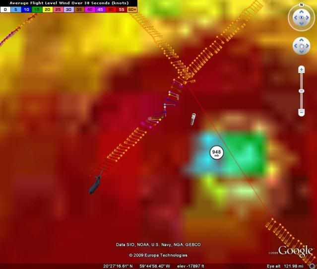
URNT12 KNHC 200630
VORTEX DATA MESSAGE AL032009
A. 20/05:53:00Z
B. 21 deg 05 min N
059 deg 37 min W
C. 700 mb 2662 m
D. 95 kt
E. 028 deg 15 nm
F. 133 deg 123 kt
G. 035 deg 25 nm
H. 949 mb
I. 9 C / 3053 m
J. 17 C / 3048 m
K. 9 C / NA
L. OPEN W-SW
M. E12/25/16
N. 12345 / 7
O. 0.02 / 0 nm
P. AF303 0303A BILL OB 09
MAX FL WIND 123 KT NE QUAD 05:45:00Z
;
Going to sleep now
0 likes
-
Hurricanewatcher2007

- Category 2

- Posts: 578
- Joined: Sat Jul 05, 2008 8:10 pm
Re: ATL: HURRICANE BILL (03L)
Heres the SSTs for the entire Atlantic Ocean
http://www.ssd.noaa.gov/PS/TROP/DATA/RT/SST/ATL/20.jpg
**EDIT** For those of you who are new to Hurricane Tracking SST stands for Sea Surface Temperature
http://www.ssd.noaa.gov/PS/TROP/DATA/RT/SST/ATL/20.jpg
**EDIT** For those of you who are new to Hurricane Tracking SST stands for Sea Surface Temperature
0 likes
-
SaskatchewanScreamer

Re: ATL: HURRICANE BILL (Models)
Major wake up call for the NE? I live on Nantucket and we have been watching this storm as soon as it was off of Africa...WTF?? It seems almost as you wishing bad luck on the North East...which is sad. Personally I don't want a hurricane to hit anywhere for anyone in the US.
0 likes
-
cheezyWXguy

- Category 5

- Posts: 6282
- Joined: Mon Feb 13, 2006 12:29 am
- Location: Dallas, TX
Re: ATL: HURRICANE BILL (Models)
DreamworksSKG wrote:Ok so it looks like BIll will just miss New England.
I am wondering how much longer our luck is going to hold.
I hope Bill was a major WAKE Up call for Boston and E mass. - and New England as to how quickly a storm can rev up to a cat 4 and with warmer ocean temps than normal can maintain strength now and move up quickly . No longer do the storms weaken to cat 1 before they get here. We have to be prepared for the next hurricane to come it could be a cat 4 this time heading right for Rhode Island up Narragansett bay.
It will happen one day, and I'm afraid it'll be soon within (3 years)
Good luck can't remain forever.
Anyway I think it'll be closer to New Eng than people thought 75 miles SE of Cape Cod ---at the closest pass maybe 100 but no less than 100. then it'll curve up into the Gulf of Maine and then curve NNE into Nova Scotia.
I like to predict landfall zones and landfall about 2-3 days out I was pretty close within 10-20 miles in several big storms of the exact eye location in the past, and in a couple cases, IVAN being one was less than 5 miles from the eye impact point.
My current thinking is somewhere between Digby-St Marys Bay Port Maitland-Yarmouth and Barrington NS.
MY initial thought on a landfall is Port Maitland near Yarmouth over St Marys Bay
we'll see
thats my prediction for now
Will be a strong cat 2 - maybe a weak cat 3 at landfall and will be moving quickly
For a post like that, newbie, you generally need a disclaimer. You should go read the rules first, and try to stay on topic (for instance, take your global warming debate to the global weather forum). Also, you act as if Bill is already past New England. It is not, and we all know how quickly a prediction not set in stone can change. Therefore, before we share your sigh of relief, lets wait a few days so the hurricane can actually pass by.
0 likes
-
somethingfunny

- ChatStaff

- Posts: 3926
- Age: 37
- Joined: Thu May 31, 2007 10:30 pm
- Location: McKinney, Texas
Re: ATL: HURRICANE BILL (03L)
I am not a professional and I am in no way implying that Bill's track will end up being the same as Edouard's, but I thought that now would be an excellent time to remind everyone of the life and times of 1996's Hurricane Edouard:

The early lifespans and the forecast tracks are very very similar. Hopefully the mid-lattitude westerlies associated with the trough can kick Bill to the curb just like Edouard.

The early lifespans and the forecast tracks are very very similar. Hopefully the mid-lattitude westerlies associated with the trough can kick Bill to the curb just like Edouard.
0 likes
-
Hurricanewatcher2007
- Category 2
- Posts: 578
- Joined: Sat Jul 05, 2008 8:10 pm
Re:
SaskatchewanScreamer wrote:Thank you Hurricanewatcher (and that would indeed be me re new to Hurricane Tracking)
Your link shows the northerly SSTs should slow Bill down somewhat.
Yeah like I said in response to some one else in the models thread the only way we really get Tropical Storms and Hurricanes impacting us this far North is if they are moving really fast because the water most of the time is just to cold to sustain them.
0 likes

-
Hurricanewatcher2007
- Category 2
- Posts: 578
- Joined: Sat Jul 05, 2008 8:10 pm
Re: ATL: HURRICANE BILL (03L)
This is interesting!
THE LARGE-SCALE MODELS SUGGEST THE CURRENT SHEAR SHOULD DIMINISH
DURING THE NEXT 24 HR...AND THIS BASIS SOME RE-INTENSIFICATION IS
EXPECTED. THE INTENSITY FORECAST IS MOST UNCERTAIN DURING THE
24-72 HR TIME FRAME AS BILL INTERACTS WITH THE CURRENT WESTERN
ATLANTIC TROUGH. THIS TROUGH COULD CAUSE SHEAR TO WEAKEN THE
SYSTEM. HOWEVER...SOME OF THE LARGE-SCALE MODELS FORECAST
INCREASED UPPER-LEVEL DIVERGENCE OVER BILL...WHICH COULD STRENGTHEN
THE HURRICANE. FOR NOW...THE INTENSITY FORECAST CALLS FOR LITTLE
CHANGE IN STRENGTH AS A COMPROMISE. AFTER 72 HR...BILL SHOULD
WEAKEN RAPIDLY AS IT MOVES OVER COLDER SEA SURFACE TEMPERATURES AND
INTO STRONG VERTICAL WIND SHEAR. EXTRATROPICAL TRANSITION SHOULD
BEGIN AROUND 96 HR AND BE COMPLETE BY 120 HR.
Well back to work on my MMO got to get the first patch out for my Alpha testers to start testing.
0 likes
-
TheEuropean

- Professional-Met
- Posts: 1797
- Age: 60
- Joined: Tue Sep 20, 2005 3:17 pm
- Location: Voerde, Germany
- Contact:
Another NOAA-Mission is on the way to Bill:
000
URNT15 KWBC 200850
NOAA3 WX03A BILL5 HDOB 07 20090820
084030 1723N 06007W 5951 04458 0036 +026 +001 197024 027 006 000 03
084100 1726N 06007W 5948 04461 0042 +025 +005 204020 022 999 999 03
084130 1728N 06007W 5950 04457 0042 +025 +001 205019 019 999 999 03
084200 1731N 06007W 5950 04456 0039 +026 +000 204019 020 009 000 03
084230 1733N 06007W 5948 04458 0034 +029 -002 206018 018 999 999 03
084300 1736N 06007W 5948 04459 0025 +034 -010 219018 019 013 000 00
084330 1738N 06007W 5950 04455 0024 +034 -009 212020 021 018 000 03
084400 1741N 06008W 5950 04455 0023 +035 -012 214021 022 005 000 00
084430 1743N 06008W 5952 04452 0023 +034 -005 212022 023 007 000 00
084500 1746N 06008W 5952 04451 0026 +032 -004 210024 025 010 002 00
084530 1748N 06008W 5951 04452 0027 +032 -010 210025 025 999 999 03
084600 1750N 06008W 5952 04452 0029 +031 -006 212026 026 005 000 03
084630 1753N 06009W 5951 04454 0033 +029 -008 211027 028 004 000 03
084700 1755N 06009W 5952 04451 0032 +028 -003 212028 029 999 999 03
084730 1758N 06010W 5953 04451 0033 +027 +008 213029 029 014 000 03
084800 1800N 06010W 5951 04451 0031 +026 +023 217028 030 021 007 03
084830 1802N 06011W 5954 04449 0026 +028 +027 226030 032 021 002 00
084900 1805N 06011W 5950 04452 0020 +032 +025 222022 023 021 002 00
084930 1807N 06011W 5950 04451 0027 +030 +002 216025 025 013 000 03
085000 1809N 06012W 5951 04451 0024 +031 +006 219025 025 013 000 00
000
URNT15 KWBC 200900
NOAA3 WX03A BILL5 HDOB 08 20090820
085030 1812N 06012W 5953 04449 0031 +028 +007 221025 026 006 000 00
085100 1814N 06012W 5953 04450 0037 +025 +008 220026 027 004 000 03
085130 1817N 06012W 5953 04449 0032 +027 +003 223026 026 999 999 03
085200 1819N 06012W 5954 04446 0032 +027 +002 225027 027 004 000 03
085230 1822N 06012W 5954 04445 0032 +026 +004 225028 028 004 000 03
085300 1824N 06012W 5954 04445 0031 +027 +003 228028 028 999 999 03
085330 1827N 06012W 5953 04445 0022 +032 -002 233028 028 003 000 03
085400 1829N 06012W 5979 04410 0027 +031 -001 234029 029 004 000 03
085430 1831N 06013W 6064 04293 0019 +041 +001 233030 030 999 999 03
085500 1834N 06013W 6165 04158 0018 +050 +006 231031 031 003 000 03
085530 1836N 06013W 6265 04026 0030 +051 +010 235031 031 999 999 03
085600 1838N 06013W 6357 03906 0029 +058 +027 232028 029 004 000 03
085630 1841N 06013W 6465 03768 0019 +073 +035 229029 029 004 000 00
085700 1843N 06014W 6562 03646 0019 +080 +049 230026 029 004 000 03
085730 1845N 06014W 6630 03560 0023 +084 +033 237023 023 003 000 03
085800 1847N 06015W 6626 03563 0025 +081 +038 234024 025 999 999 03
085830 1850N 06015W 6626 03564 0030 +078 +040 227025 025 999 999 03
085900 1852N 06016W 6625 03566 0037 +073 +043 228024 025 002 000 03
085930 1854N 06017W 6626 03564 0037 +073 +042 225024 025 999 999 03
090000 1856N 06017W 6627 03561 0030 +076 +047 229030 032 004 000 03
000
URNT15 KWBC 200850
NOAA3 WX03A BILL5 HDOB 07 20090820
084030 1723N 06007W 5951 04458 0036 +026 +001 197024 027 006 000 03
084100 1726N 06007W 5948 04461 0042 +025 +005 204020 022 999 999 03
084130 1728N 06007W 5950 04457 0042 +025 +001 205019 019 999 999 03
084200 1731N 06007W 5950 04456 0039 +026 +000 204019 020 009 000 03
084230 1733N 06007W 5948 04458 0034 +029 -002 206018 018 999 999 03
084300 1736N 06007W 5948 04459 0025 +034 -010 219018 019 013 000 00
084330 1738N 06007W 5950 04455 0024 +034 -009 212020 021 018 000 03
084400 1741N 06008W 5950 04455 0023 +035 -012 214021 022 005 000 00
084430 1743N 06008W 5952 04452 0023 +034 -005 212022 023 007 000 00
084500 1746N 06008W 5952 04451 0026 +032 -004 210024 025 010 002 00
084530 1748N 06008W 5951 04452 0027 +032 -010 210025 025 999 999 03
084600 1750N 06008W 5952 04452 0029 +031 -006 212026 026 005 000 03
084630 1753N 06009W 5951 04454 0033 +029 -008 211027 028 004 000 03
084700 1755N 06009W 5952 04451 0032 +028 -003 212028 029 999 999 03
084730 1758N 06010W 5953 04451 0033 +027 +008 213029 029 014 000 03
084800 1800N 06010W 5951 04451 0031 +026 +023 217028 030 021 007 03
084830 1802N 06011W 5954 04449 0026 +028 +027 226030 032 021 002 00
084900 1805N 06011W 5950 04452 0020 +032 +025 222022 023 021 002 00
084930 1807N 06011W 5950 04451 0027 +030 +002 216025 025 013 000 03
085000 1809N 06012W 5951 04451 0024 +031 +006 219025 025 013 000 00
000
URNT15 KWBC 200900
NOAA3 WX03A BILL5 HDOB 08 20090820
085030 1812N 06012W 5953 04449 0031 +028 +007 221025 026 006 000 00
085100 1814N 06012W 5953 04450 0037 +025 +008 220026 027 004 000 03
085130 1817N 06012W 5953 04449 0032 +027 +003 223026 026 999 999 03
085200 1819N 06012W 5954 04446 0032 +027 +002 225027 027 004 000 03
085230 1822N 06012W 5954 04445 0032 +026 +004 225028 028 004 000 03
085300 1824N 06012W 5954 04445 0031 +027 +003 228028 028 999 999 03
085330 1827N 06012W 5953 04445 0022 +032 -002 233028 028 003 000 03
085400 1829N 06012W 5979 04410 0027 +031 -001 234029 029 004 000 03
085430 1831N 06013W 6064 04293 0019 +041 +001 233030 030 999 999 03
085500 1834N 06013W 6165 04158 0018 +050 +006 231031 031 003 000 03
085530 1836N 06013W 6265 04026 0030 +051 +010 235031 031 999 999 03
085600 1838N 06013W 6357 03906 0029 +058 +027 232028 029 004 000 03
085630 1841N 06013W 6465 03768 0019 +073 +035 229029 029 004 000 00
085700 1843N 06014W 6562 03646 0019 +080 +049 230026 029 004 000 03
085730 1845N 06014W 6630 03560 0023 +084 +033 237023 023 003 000 03
085800 1847N 06015W 6626 03563 0025 +081 +038 234024 025 999 999 03
085830 1850N 06015W 6626 03564 0030 +078 +040 227025 025 999 999 03
085900 1852N 06016W 6625 03566 0037 +073 +043 228024 025 002 000 03
085930 1854N 06017W 6626 03564 0037 +073 +042 225024 025 999 999 03
090000 1856N 06017W 6627 03561 0030 +076 +047 229030 032 004 000 03
0 likes
Who is online
Users browsing this forum: No registered users and 47 guests