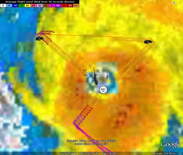
ATL: TROPICAL STORM BILL (03L)

Moderator: S2k Moderators

Message
Author
User avatar
UpTheCreek
Category 1
Category 1
Posts: 397
Age: 61
Joined: Tue Aug 31, 2004 5:28 pm
Location: Vassalboro, Maine

Re:

#3221 Postby UpTheCreek » Thu Aug 20, 2009 12:55 pm

deltadog03 wrote:Image


Thanks for that image, helped me understand IMMENSELY! :wink:
0 likes   

User avatar
Hybridstorm_November2001
S2K Supporter
S2K Supporter
Posts: 2811
Joined: Sat Aug 21, 2004 2:50 pm
Location: SW New Brunswick, Canada
Contact:

#3222 Postby Hybridstorm_November2001 » Thu Aug 20, 2009 12:56 pm

And looks like maybe even hurricane force winds into where I am near the tip of SW New Brunswick. I don't like this run of the CMC at all. :eek:
0 likes   

User avatar
HURAKAN
Professional-Met
Professional-Met
Posts: 46086
Age: 38
Joined: Thu May 20, 2004 4:34 pm
Location: Key West, FL
Contact:

#3223 Postby HURAKAN » Thu Aug 20, 2009 1:00 pm

000
URNT15 KNHC 201744
AF304 0403A BILL HDOB 21 20090820
173430 2346N 06325W 6969 03060 9960 +091 +025 055064 065 999 999 03
173500 2345N 06323W 6967 03059 9962 +085 +026 053066 067 999 999 03
173530 2344N 06322W 6972 03050 9970 +074 +027 051063 064 999 999 03
173600 2343N 06321W 6959 03061 9966 +073 +027 048064 065 999 999 03
173630 2342N 06319W 6974 03035 9961 +071 +027 050067 068 086 020 03
173700 2341N 06318W 6959 03051 9960 +067 +027 054073 074 082 022 03
173730 2340N 06317W 6978 03025 9935 +087 +026 057063 066 077 006 03
173800 2339N 06315W 6964 03039 9914 +098 +027 056063 063 078 005 03
173830 2338N 06314W 6970 03027 9909 +099 +030 056067 068 999 999 03
173900 2337N 06313W 6966 03023 9896 +104 +033 054063 065 083 003 03
173930 2336N 06312W 6967 03012 9883 +106 +036 050063 063 999 999 03
174000 2335N 06310W 6974 03000 9873 +109 +040 051063 063 999 999 03
174030 2334N 06309W 6962 03011 9874 +103 +043 050063 063 999 999 03
174100 2333N 06308W 6965 02998 9866 +104 +044 050064 065 999 999 03
174130 2332N 06306W 6970 02986 9860 +101 +043 049066 068 999 999 03
174200 2330N 06305W 6970 02978 9848 +104 +040 043066 068 999 999 03
174230 2329N 06304W 6971 02970 9835 +108 +038 044070 071 999 999 03
174300 2328N 06302W 6966 02966 9825 +108 +037 040069 070 999 999 03
174330 2327N 06301W 6967 02954 9810 +110 +036 038070 070 999 999 03
174400 2326N 06259W 6962 02945 9790 +116 +036 036072 073 999 999 03
$$
;

000
URNT15 KNHC 201755
AF304 0403A BILL HDOB 22 20090820
174430 2325N 06258W 6969 02924 9767 +122 +036 033074 075 999 999 03
174500 2324N 06256W 6935 02953 9755 +118 +036 028075 077 999 999 03
174530 2322N 06255W 6945 02923 9752 +107 +036 025077 079 999 999 03
174600 2321N 06253W 6943 02905 9729 +106 +033 021081 082 999 999 03
174630 2320N 06252W 6944 02881 9696 +114 +030 016084 085 999 999 03
174700 2319N 06250W 6940 02864 9697 +091 +027 012077 079 093 017 03
174730 2317N 06249W 6928 02855 9678 +083 +024 011092 100 097 030 03
174800 2316N 06247W 6919 02827 9631 +090 +022 006087 097 097 031 03
174830 2314N 06245W 6949 02763 9579 +113 +022 350068 070 095 014 03
174900 2314N 06243W 6931 02772 9518 +158 +025 351056 061 999 999 03
174930 2314N 06241W 6945 02737 9498 +158 +030 353036 046 999 999 03
175000 2314N 06239W 6935 02735 9482 +158 +038 354017 025 999 999 03
175030 2314N 06237W 6955 02706 9480 +154 +044 044006 010 999 999 03
175100 2314N 06236W 6933 02732 9490 +144 +049 108004 006 999 999 03
175130 2314N 06234W 6937 02730 9492 +140 +050 135007 009 999 999 03
175200 2314N 06232W 6947 02717 9499 +135 +050 143013 015 999 999 03
175230 2314N 06230W 6941 02721 9494 +138 +049 152018 021 999 999 03
175300 2315N 06228W 6939 02723 9481 +146 +048 156022 023 999 999 03
175330 2315N 06226W 6945 02722 9484 +149 +047 153024 026 999 999 03
175400 2313N 06225W 6937 02723 9473 +154 +048 165027 031 999 999 03
$$
;

Extra: 948 mb
0 likes   

User avatar
HURAKAN
Professional-Met
Professional-Met
Posts: 46086
Age: 38
Joined: Thu May 20, 2004 4:34 pm
Location: Key West, FL
Contact:

#3224 Postby HURAKAN » Thu Aug 20, 2009 1:00 pm

Image
0 likes   

User avatar
KWT
Category 5
Category 5
Posts: 31415
Joined: Tue Aug 17, 2004 11:02 am
Location: UK!!!

#3225 Postby KWT » Thu Aug 20, 2009 1:01 pm

Yep the CMC is very interesting, gets very close to the NE of the US indeed, wil lbe interesting to see where the 12z ECM ends up I suppose!
0 likes   

User avatar
srainhoutx
S2K Supporter
S2K Supporter
Posts: 6919
Age: 67
Joined: Sun Jan 14, 2007 11:34 am
Location: Haywood County, NC
Contact:

Re: Re:

#3226 Postby srainhoutx » Thu Aug 20, 2009 1:05 pm

deltadog03 wrote:
Derek Ortt wrote:this may turn WNW later today for about 12 hours. The UL to its NW appears to be cutting off


I agree Derek. That ULL is going to be very important **IMO** to where it gets to in the long run. This could make it fairly close to the NE in the long run.
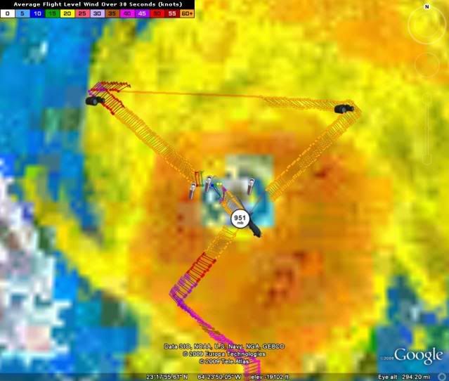

Derek and deltadog03, I hope you don't mind my "big picture" look at the feature you both are discussing...

http://wxweb.meteostar.com/models/noaap ... UMBLOOP=10
0 likes   

Shaun2453
Tropical Low
Tropical Low
Posts: 14
Joined: Tue Jul 22, 2008 10:25 am

Re: ATL: HURRICANE BILL (03L)

#3227 Postby Shaun2453 » Thu Aug 20, 2009 1:06 pm

sigh >>>>

You have attempted to navigate to a site that is blocked because it is categorized as Personal Network Storage and Backup

sucks to try and follow this from behind a corporate firewall - Is there any other way I can get a copy. specially if it helps explain 'stuff' lol

Thnx
0 likes   

CrazyC83
Professional-Met
Professional-Met
Posts: 34002
Joined: Tue Mar 07, 2006 11:57 pm
Location: Deep South, for the first time!

Re: ATL: HURRICANE BILL (03L)

#3228 Postby CrazyC83 » Thu Aug 20, 2009 1:06 pm

cheezyWXguy wrote:
hurricanefloyd5 wrote:with FL winds of 135kts we should see an upgrade back to Cat.4 again at 2pm if not sooner!!!!!!!!

To be honest, there are a few holes in your "logic." When FL winds were over 140kt yesterday, we still barely had a 115kt storm at the surface. Also, there is no 2pm advisory because no advisories are out, and there is absolutely no reason for a special advisory at this point.

So...


Given all the available information, I'd stick to 105 kt, or maybe bump it to 110 kt if the closed wall suggests strengthening.
0 likes   

OuterBanker
S2K Supporter
S2K Supporter
Posts: 1731
Joined: Wed Feb 26, 2003 10:53 am
Location: Nags Head, NC
Contact:

#3229 Postby OuterBanker » Thu Aug 20, 2009 1:06 pm

Hey storms. I have to go to DC this weekend because a friends daughter is getting married.
Unfortunately, I will not be back until Sunday which means I will miss the surf.
We have our nephew staying with us this summer and he is so stoked that he bought new fins for his board because of the expected surf.
(he isn't going and I'm just a tad jealous)
NOAA is calling for 15 to 20 ft here in Nags Head.
For those of you that aren’t aware, when we have this kind of surf surfers from all over the east coast head here. Bill should make for the perfect scene. Far enough away to produce large clean surf with no rain, wind, etc.
Personally, I'm hoping for the perfect storm. One that has no ill effects, no damages, stabilizes the atmosphere and produces great surf.
0 likes   

User avatar
HURAKAN
Professional-Met
Professional-Met
Posts: 46086
Age: 38
Joined: Thu May 20, 2004 4:34 pm
Location: Key West, FL
Contact:

#3230 Postby HURAKAN » Thu Aug 20, 2009 1:08 pm

Image

Continues to look good
0 likes   

User avatar
HURAKAN
Professional-Met
Professional-Met
Posts: 46086
Age: 38
Joined: Thu May 20, 2004 4:34 pm
Location: Key West, FL
Contact:

#3231 Postby HURAKAN » Thu Aug 20, 2009 1:10 pm

294
URNT15 KNHC 201804
AF304 0403A BILL HDOB 23 20090820
175430 2312N 06224W 6943 02716 9467 +163 +049 180036 040 999 999 03
175500 2311N 06223W 6939 02728 9472 +164 +050 191046 053 999 999 03
175530 2310N 06221W 6939 02740 9483 +164 +052 196061 065 999 999 03
175600 2309N 06220W 6947 02736 9507 +153 +053 204072 077 999 999 03
175630 2308N 06219W 6938 02767 9538 +140 +053 206089 092 999 999 03
175700 2307N 06218W 6933 02796 9577 +125 +050 212104 108 999 999 03
175730 2307N 06218W 6933 02796 9612 +115 +045 215115 117 093 000 03
175800 2305N 06217W 6944 02829 9634 +120 +038 213113 115 092 000 03
175830 2304N 06216W 6954 02837 9678 +101 +030 212113 114 090 004 03
175900 2303N 06215W 6935 02879 9681 +117 +022 212108 109 085 003 03
175930 2302N 06214W 6937 02902 9719 +105 +017 212107 107 085 000 03
180000 2301N 06213W 6940 02916 9733 +110 +013 211108 109 082 001 00
180030 2300N 06212W 6939 02931 9751 +108 +010 211105 107 081 002 00
180100 2259N 06211W 6943 02937 9763 +111 +009 210103 103 079 001 00
180130 2258N 06210W 6938 02957 9778 +110 +009 210101 101 077 000 03
180200 2257N 06209W 6942 02966 9794 +108 +011 211099 100 077 000 03
180230 2256N 06208W 6936 02984 9806 +107 +014 210096 097 076 000 03
180300 2255N 06208W 6941 02987 9815 +110 +016 211096 096 074 000 03
180330 2254N 06207W 6938 02998 9828 +104 +019 212094 095 073 000 03
180400 2253N 06206W 6943 03001 9843 +100 +020 210091 092 073 000 03
$$
;
0 likes   

User avatar
HURAKAN
Professional-Met
Professional-Met
Posts: 46086
Age: 38
Joined: Thu May 20, 2004 4:34 pm
Location: Key West, FL
Contact:

#3232 Postby HURAKAN » Thu Aug 20, 2009 1:11 pm

Image

Someone please take over.
0 likes   

User avatar
cycloneye
Admin
Admin
Posts: 145365
Age: 68
Joined: Thu Oct 10, 2002 10:54 am
Location: San Juan, Puerto Rico

Re: ATL: HURRICANE BILL (Models)

#3233 Postby cycloneye » Thu Aug 20, 2009 1:20 pm

12z UKMET hits hard Nova Scotia,well east from Cape Cod.

GLOBAL MODEL DATA TIME 12UTC 20.08.2009

HURRICANE BILL ANALYSED POSITION : 21.9N 61.2W

ATCF IDENTIFIER : AL032009

VERIFYING TIME POSITION STRENGTH TENDENCY
-------------- -------- -------- --------
12UTC 20.08.2009 21.9N 61.2W INTENSE
00UTC 21.08.2009 23.8N 63.8W INTENSE INTENSIFYING RAPIDLY
12UTC 21.08.2009 26.4N 66.0W INTENSE LITTLE CHANGE
00UTC 22.08.2009 29.0N 67.8W INTENSE LITTLE CHANGE
12UTC 22.08.2009 32.0N 68.9W INTENSE WEAKENING SLIGHTLY
00UTC 23.08.2009 35.8N 68.5W INTENSE LITTLE CHANGE
12UTC 23.08.2009 40.3N 66.8W INTENSE WEAKENING SLIGHTLY
00UTC 24.08.2009 44.8N 63.4W STRONG WEAKENING SLIGHTLY
12UTC 24.08.2009 48.2N 56.4W INTENSE INTENSIFYING SLIGHTLY
00UTC 25.08.2009 50.4N 44.0W MODERATE WEAKENING RAPIDLY
12UTC 25.08.2009 EXTRA-TROPICAL
0 likes   

otowntiger
Category 5
Category 5
Posts: 1921
Joined: Tue Aug 31, 2004 7:06 pm

Re: ATL: HURRICANE BILL (Models)

#3234 Postby otowntiger » Thu Aug 20, 2009 1:36 pm

That run also shows another storm following Bills path and intensity almost exactly except it appears to recurve a little further east threatening Bermuda more than it appears Bill will.
0 likes   

cyclonebuster

#3235 Postby cyclonebuster » Thu Aug 20, 2009 1:42 pm

Bill is gobbeling up his second ULL today NNW of Bill located @ 66W AND 34N. You can watch the ULL dissapear in about 12 hours on the vapor loop HERE! This may cause Bill to follow the ULL to his WNW located @ 72W and 27N.


http://www.ssd.noaa.gov/goes/east/eaus/loop-wv.html
Image
0 likes   

User avatar
cycloneye
Admin
Admin
Posts: 145365
Age: 68
Joined: Thu Oct 10, 2002 10:54 am
Location: San Juan, Puerto Rico

Re: ATL: HURRICANE BILL (03L)

#3236 Postby cycloneye » Thu Aug 20, 2009 1:42 pm

18 UTC Best Track bumped winds to 110 kts.

AL, 03, 2009082018, , BEST, 0, 232N, 626W, 110, 948, HU

ftp://ftp.tpc.ncep.noaa.gov/atcf/tcweb/ ... 009.invest
0 likes   

User avatar
KWT
Category 5
Category 5
Posts: 31415
Joined: Tue Aug 17, 2004 11:02 am
Location: UK!!!

#3237 Postby KWT » Thu Aug 20, 2009 1:45 pm

Not that surprising given what was found at flight level today, now once again pretty close to category-4 strength, I certainly think it looks a little better now. Cycloneye, its got a nice eye thats for sure!
0 likes   

User avatar
cycloneye
Admin
Admin
Posts: 145365
Age: 68
Joined: Thu Oct 10, 2002 10:54 am
Location: San Juan, Puerto Rico

Re: ATL : BILL (03L) Recon Thread

#3238 Postby cycloneye » Thu Aug 20, 2009 1:52 pm

The previous mission is over.The next three ones are below.

FLIGHT TWO -- NOAA 49
A. 21/0000Z
B. NOAA9 0503A BILL
C. 20/1730Z
D. NA
E. NA
F. 41,000 TO 45,000 FT

FLIGHT THREE -- TEAL 73
A. 21/0000Z
B. AFXXX 0603A BILL
C. 20/1730Z
D. NA
E. NA
F. 24,000 TO 30,000 FT

FLIGHT FOUR -- TEAL 71
A. 21/0600Z
B. AFXXX 0703A BILL
C. 21/0200Z
D. 24.4N 64.4W
E. 20/0400Z TO 20/0830Z
F. SFC TO 10,000 FT

http://www.nhc.noaa.gov/reconlist.shtml
0 likes   

User avatar
cycloneye
Admin
Admin
Posts: 145365
Age: 68
Joined: Thu Oct 10, 2002 10:54 am
Location: San Juan, Puerto Rico

Re: ATL: HURRICANE BILL (Models)

#3239 Postby cycloneye » Thu Aug 20, 2009 1:56 pm

If 12z NOGAPS is right,Cape Cod gets hurricane force winds.

http://moe.met.fsu.edu/cgi-bin/ngptc2.c ... =Animation

Image
0 likes   

Shaun2453
Tropical Low
Tropical Low
Posts: 14
Joined: Tue Jul 22, 2008 10:25 am

Re:

#3240 Postby Shaun2453 » Thu Aug 20, 2009 2:00 pm

cyclonebuster wrote:Bill is gobbeling up his second ULL today NNW of Bill located @ 66W AND 34N. You can watch the ULL dissapear in about 12 hours on the vapor loop HERE! This may cause Bill to follow the ULL to his WNW located @ 72W and 27N.


http://www.ssd.noaa.gov/goes/east/eaus/loop-wv.html
Image


So ULL 's are represented by the black/ uncoloured areas and storms are pushed/ pulled/ move to try and find them (appreciate that may just be one of many factors)...?
0 likes   


Return to “2009”

Who is online

Users browsing this forum: No registered users and 7 guests