The following post is NOT an official forecast and should not be used as such. It is just the opinion of the poster and may or may not be backed by sound meteorological data. It is NOT endorsed by any professional institution including storm2k.org For Official Information please refer to the NHC and NWS products.
The Bailey model will put this low inland at 87.8 - 30.2 in about 28-32 hr's
***This is just my opinion of where and when this low will go "thus the Bailey model"***
GOM: INVEST 90L
Moderator: S2k Moderators
-
Bailey1777
- S2K Supporter

- Posts: 962
- Joined: Mon Jul 31, 2006 6:23 pm
- Location: Houston, Texas
-
Bailey1777
- S2K Supporter
- Posts: 962
- Joined: Mon Jul 31, 2006 6:23 pm
- Location: Houston, Texas
-
Category 5

- Category 5

- Posts: 10074
- Age: 36
- Joined: Sun Feb 11, 2007 10:00 pm
- Location: New Brunswick, NJ
- Contact:
Re:
Bailey1777 wrote:The following post is NOT an official forecast and should not be used as such. It is just the opinion of the poster and may or may not be backed by sound meteorological data. It is NOT endorsed by any professional institution including storm2k.org For Official Information please refer to the NHC and NWS products.
The Bailey model will put this low inland at 87.8 - 30.2 in about 28-32 hr's
I didnt know computer models could post on message boards.
0 likes
-
vbhoutex

- Storm2k Executive

- Posts: 29149
- Age: 74
- Joined: Wed Oct 09, 2002 11:31 pm
- Location: Cypress, TX
- Contact:
Re: GOM: INVEST 90L
Stormcenter wrote:I'm sorry but 90L still looks like crap. Yes I know looks can be deceiving but in this case I think they are not.
Unless the dry air entrainment stops it appears to be doomed to me. I do understand them doing an Invest, just in case, but conditions currently don't look too hopeful for 90L.
0 likes
-
Bailey1777
- S2K Supporter
- Posts: 962
- Joined: Mon Jul 31, 2006 6:23 pm
- Location: Houston, Texas
-
HURAKAN

- Professional-Met

- Posts: 46084
- Age: 39
- Joined: Thu May 20, 2004 4:34 pm
- Location: Key West, FL
- Contact:
GOM: Invest 90L RECON - Cancelled
354
NOUS42 KNHC 221600
WEATHER RECONNAISSANCE FLIGHTS
CARCAH, NATIONAL HURRICANE CENTER, MIAMI, FL.
1200 PM EDT FRI 22 MAY 2009
SUBJECT: TROPICAL CYCLONE PLAN OF THE DAY (TCPOD)
VALID 23/1100Z TO 24/1100Z FEB 2009
WSPOD NUMBER.....09-001
I. ATLANTIC REQUIREMENTS
1. SUSPECT AREA IN GULF OF MEXICO
FLIGHT ONE -- TEAL 70
A. 23/1600Z
B. AFXXX 01AAA INVEST
C. 23/1500Z
D. 29.7N AND 88.7W
E. 23/1500Z TO 23/2300Z
F. SFC TO 10,000 FT
2. SUCCEEDING DAY OUTLOOK.....NEGATIVE.
II. PACIFIC REQUIREMENTS
1. NEGATIVE RECONNAISSANCE REQUIREMENTS.
2. OUTLOOK FOR SUCCEEDING DAY.....NEGATIVE.
WVW
0 likes
-
vbhoutex
- Storm2k Executive
- Posts: 29149
- Age: 74
- Joined: Wed Oct 09, 2002 11:31 pm
- Location: Cypress, TX
- Contact:
Re: GOM: Invest 90L Models
Stormcenter wrote:90L is still not doing much so I'm not sure why the invest now.
It actually looked "better" yesterday. Oh well hopefully
it will bring some beneficial rains to the areas that need it.
http://www.ssd.noaa.gov/goes/east/gmex/loop-vis.html
Two possibilities. They see something we don't that makes them believe it needs more emphasis or they are being cautious since it has to landfall somewhere and there is a possibility it could become tropical(however small).
0 likes
-
Ed Mahmoud
Re: GOM: Invest 90L RECON - 23/1600Z
In my unscientific opinion, there is a 67% chance the mission will canx tomorrow...
0 likes

Re: GOM: INVEST 90L
I would think the farther to the east of that little Upper low (spinning south of the Miss. coast)that it gets, that the conditions will improve with the exception of SST's.and will probably bend back to the NW before heading N then NNE. MSG and points east will likely see a great deal of rain. IMHO
If this is correct then that could be why they made it an Invest

If this is correct then that could be why they made it an Invest
0 likes
-
Ed Mahmoud
Re: GOM: Invest 90L Models
Code: Select all
WHXX01 KWBC 221436

CHGHUR

TROPICAL CYCLONE GUIDANCE MESSAGE

NWS TPC/NATIONAL HURRICANE CENTER MIAMI FL

1436 UTC FRI MAY 22 2009


DISCLAIMER...NUMERICAL MODELS ARE SUBJECT TO LARGE ERRORS.

PLEASE REFER TO NHC OFFICIAL FORECASTS FOR TROPICAL CYCLONE

AND SUBTROPICAL CYCLONE INFORMATION.


ATLANTIC OBJECTIVE AIDS FOR


DISTURBANCE INVEST (AL902009) 20090522 1200 UTC


        ...00 HRS...   ...12 HRS...   ...24 HRS. ..   ...36 HRS...

        090522  1200   090523  0000   090523  1200   090524  0000


         LAT    LON     LAT    LON     LAT    LON     LAT    LON

BAMS    26.6N  87.3W   27.8N  88.2W   29.1N  89.0W   30.4N  89.6W

BAMD    26.6N  87.3W   27.8N  87.5W   29.2N  88.0W   31.1N  88.9W

BAMM    26.6N  87.3W   27.8N  87.7W   29.2N  88.1W   30.9N  88.6W

LBAR    26.6N  87.3W   27.7N  87.3W   29.1N  87.5W   30.6N  87.7W

SHIP        25KTS          29KTS          34KTS          41KTS

DSHP        25KTS          29KTS          34KTS          33KTS


        ...48 HRS...   ...72 HRS...   ...96 HRS. ..   ..120 HRS...

        090524  1200   090525  1200   090526  1200   090527  1200


         LAT    LON     LAT    LON     LAT    LON     LAT    LON

BAMS    31.9N  90.1W   34.8N  91.1W   37.7N  91.1W   39.8N  89.3W

BAMD    33.0N  90.1W   36.5N  92.7W   40.1N  93.8W   42.0N  91.8W

BAMM    32.8N  89.3W   36.2N  90.8W   39.6N  91.3W   41.8N  88.6W

LBAR    32.2N  87.8W   35.1N  87.0W   37.4N  83.9W   38.5N  78.6W

SHIP        45KTS          52KTS          51KTS          52KTS

DSHP        29KTS          27KTS          29KTS          30KTS


         ...INITIAL CONDITIONS...

LATCUR =  26.6N LONCUR =  87.3W DIRCUR =   0DEG SPDCUR =   4KT

LATM12 =  26.0N LONM12 =  86.8W DIRM12 = 294DEG SPDM12 =   5KT

LATM24 =  25.5N LONM24 =  86.3W

WNDCUR =   25KT RMAXWD =  125NM WNDM12 =   25KT

CENPRS = 1006MB OUTPRS = 1011MB OUTRAD =  300NM SDEPTH =   M

RD34NE =    0NM RD34SE =    0NM RD34SW =    0NM RD34NW =   0NM


$$

NNNN
0 likes
-
HURAKAN
- Professional-Met
- Posts: 46084
- Age: 39
- Joined: Thu May 20, 2004 4:34 pm
- Location: Key West, FL
- Contact:
TROPICAL WEATHER DISCUSSION
NWS TPC/NATIONAL HURRICANE CENTER MIAMI FL
205 PM EDT FRI MAY 22 2009
...DISCUSSION...
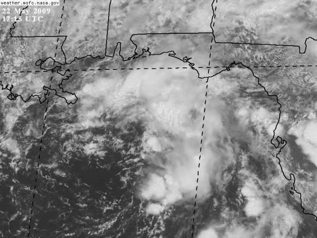
THE GULF OF MEXICO...
A 1005 MB LOW IS OVER THE E GULF OF MEXICO NEAR 27N87W. BANDS OF
WIDELY SCATTERED MODERATE CONVECTION ARE OVER THE NE GULF OF
MEXICO AND FLORIDA FROM 24N-31N BETWEEN 80W-87W. A TIGHT
PRESSURE GRADIENT OVER THE NE GULF IS PRODUCING 20-25 KT WINDS N
OF 27N E OF 90W. THE W GULF OF MEXICO W OF 90W HAS PARTLY CLOUDY
SKIES WITH 10-15 KT N WINDS. IN THE UPPER LEVELS...AN UPPER
LEVEL LOW IS CENTERED OVER THE NORTH CENTRAL GULF NEAR 29N88W.
THE NE GULF AND FLORIDA HAS ABUNDANT UPPER AIR MOISTURE WHILE
STRONG SUBSIDENCE IS OVER THE REMAINDER OF THE GULF.
EXPECT...THE SURFACE LOW TO DRIFT NW TO THE LOUISIANA COAST OVER
THE NEXT 24 HOURS WITH CONVECTION MOSTLY E OF THE CENTER.
NWS TPC/NATIONAL HURRICANE CENTER MIAMI FL
205 PM EDT FRI MAY 22 2009
...DISCUSSION...
THE GULF OF MEXICO...
A 1005 MB LOW IS OVER THE E GULF OF MEXICO NEAR 27N87W. BANDS OF
WIDELY SCATTERED MODERATE CONVECTION ARE OVER THE NE GULF OF
MEXICO AND FLORIDA FROM 24N-31N BETWEEN 80W-87W. A TIGHT
PRESSURE GRADIENT OVER THE NE GULF IS PRODUCING 20-25 KT WINDS N
OF 27N E OF 90W. THE W GULF OF MEXICO W OF 90W HAS PARTLY CLOUDY
SKIES WITH 10-15 KT N WINDS. IN THE UPPER LEVELS...AN UPPER
LEVEL LOW IS CENTERED OVER THE NORTH CENTRAL GULF NEAR 29N88W.
THE NE GULF AND FLORIDA HAS ABUNDANT UPPER AIR MOISTURE WHILE
STRONG SUBSIDENCE IS OVER THE REMAINDER OF THE GULF.
EXPECT...THE SURFACE LOW TO DRIFT NW TO THE LOUISIANA COAST OVER
THE NEXT 24 HOURS WITH CONVECTION MOSTLY E OF THE CENTER.
0 likes


-
HURAKAN
- Professional-Met
- Posts: 46084
- Age: 39
- Joined: Thu May 20, 2004 4:34 pm
- Location: Key West, FL
- Contact:
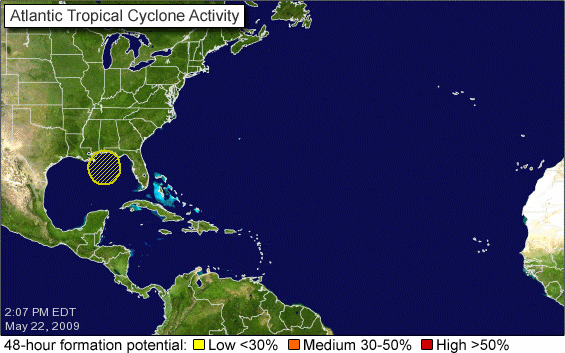
916
ABNT20 KNHC 221805
TWOAT
SPECIAL TROPICAL WEATHER OUTLOOK
NWS TPC/NATIONAL HURRICANE CENTER MIAMI FL
205 PM EDT FRI MAY 22 2009
FOR THE NORTH ATLANTIC...CARIBBEAN SEA AND THE GULF OF MEXICO...
SATELLITE IMAGES INDICATE THAT SHOWERS AND THUNDERSTORMS ASSOCIATED
WITH A BROAD AREA OF LOW PRESSURE OVER THE NORTH-CENTRAL GULF OF
MEXICO HAVE INCREASED TODAY. SOME SLOW DEVELOPMENT OF THIS SYSTEM
IS POSSIBLE AS IT MOVES SLOWLY NORTHWARD...AND AN AIR FORCE RESERVE
HURRICANE HUNTER AIRCRAFT WILL INVESTIGATE THE LOW TOMORROW...IF
NECESSARY. THERE IS A LOW CHANCE...LESS THAN 30 PERCENT...OF
TROPICAL CYCLONE DEVELOPMENT IN THIS AREA BEFORE THE SYSTEM REACHES
THE COAST ON SATURDAY. REGARDLESS OF DEVELOPMENT...HEAVY RAINS AND
OCCASIONALLY GUSTY WINDS ARE EXPECTED ALONG PORTIONS OF THE
NORTHERN GULF COAST TODAY AND SATURDAY.
$$
FORECASTER KIMBERLAIN/FRANKLIN
0 likes


Re:
[quote="HURAKAN"]916
ABNT20 KNHC 221805
TWOAT
SPECIAL TROPICAL WEATHER OUTLOOK
NWS TPC/NATIONAL HURRICANE CENTER MIAMI FL
205 PM EDT FRI MAY 22 2009
FOR THE NORTH ATLANTIC...CARIBBEAN SEA AND THE GULF OF MEXICO...
SATELLITE IMAGES INDICATE THAT SHOWERS AND THUNDERSTORMS ASSOCIATED
WITH A BROAD AREA OF LOW PRESSURE OVER THE NORTH-CENTRAL GULF OF
MEXICO HAVE INCREASED TODAY. SOME SLOW DEVELOPMENT OF THIS SYSTEM
IS POSSIBLE AS IT MOVES SLOWLY NORTHWARD...AND AN AIR FORCE RESERVE
HURRICANE HUNTER AIRCRAFT WILL INVESTIGATE THE LOW TOMORROW...IF
NECESSARY. THERE IS A LOW CHANCE...LESS THAN 30 PERCENT...OF
TROPICAL CYCLONE DEVELOPMENT IN THIS AREA BEFORE THE SYSTEM REACHES
THE COAST ON SATURDAY. REGARDLESS OF DEVELOPMENT...HEAVY RAINS AND
OCCASIONALLY GUSTY WINDS ARE EXPECTED ALONG PORTIONS OF THE
NORTHERN GULF COAST TODAY AND SATURDAY.
$$
FORECASTER KIMBERLAIN/FRANKLIN
[img]http://i40.photobucket.com/albums/e244/zdtadmin/atl_overview-1.gif[/img][/quote]
I'm a little confused...the earlier statement said that it was moving NW and Franklin says that it is moving Nwd...do we split the difference and call it's movement NNW...not that it really makes that much of a difference
0 likes
-
Bailey1777
- S2K Supporter
- Posts: 962
- Joined: Mon Jul 31, 2006 6:23 pm
- Location: Houston, Texas
-
cycloneye

- Admin
- Posts: 149508
- Age: 69
- Joined: Thu Oct 10, 2002 10:54 am
- Location: San Juan, Puerto Rico
Re: GOM: INVEST 90L - STWO: Less than 30%
18z Best Track data:
AL, 90, 2009052218, , BEST, 0, 271N, 873W, 25, 1006, LO, 0, , 0, 0, 0, 0,
ftp://ftp.tpc.ncep.noaa.gov/atcf/tcweb/
AL, 90, 2009052218, , BEST, 0, 271N, 873W, 25, 1006, LO, 0, , 0, 0, 0, 0,
ftp://ftp.tpc.ncep.noaa.gov/atcf/tcweb/
0 likes
-
wxman57

- Moderator-Pro Met

- Posts: 23175
- Age: 68
- Joined: Sat Jun 21, 2003 8:06 pm
- Location: Houston, TX (southwest)
Re: GOM: Invest 90L RECON - 23/1600Z
Maybe more like 95% it'll cancel, as the low will be inland by mid morning.
0 likes
Who is online
Users browsing this forum: No registered users and 37 guests