ATL: TROPICAL DEPRESSION HENRI (10L)
Moderator: S2k Moderators
-
dixiebreeze

- S2K Supporter

- Posts: 5140
- Joined: Wed Sep 03, 2003 5:07 pm
- Location: crystal river, fla.
Re: ATL: TROPICAL STORM HENRI (10L)
Still surprised that no Recon is scheduled for a TS this far west.
0 likes
-
Aric Dunn
- Category 5

- Posts: 21238
- Age: 43
- Joined: Sun Sep 19, 2004 9:58 pm
- Location: Ready for the Chase.
- Contact:
I would not be surprised to see a motion of 280 to 285 over night with as much convection that it has right now..
midlevel steering is pretty clear that the 290 300 degrees wont last with deep convection like this .. here is the mid level steering.. it will begin to slow down here overnight as it begins to run into the ridge.
i would say it barely makes it past 60 west and 20 north before stalling briefly and turning wsw.
0 likes

Re: ATL: TROPICAL STORM HENRI (10L)
Seems like the convection may be partially covering the center again with that last burst. Its hard to tell though at night.
http://rammb.cira.colostate.edu/ramsdis ... _floater_2
http://rammb.cira.colostate.edu/ramsdis ... _floater_2
0 likes
-
Aric Dunn
- Category 5
- Posts: 21238
- Age: 43
- Joined: Sun Sep 19, 2004 9:58 pm
- Location: Ready for the Chase.
- Contact:
Re: ATL: TROPICAL STORM HENRI (10L)
This is interesting.. oh well posting that in here keep screwing up the alignment... so here is the link...
http://cimss.ssec.wisc.edu/tropic2/real ... 000&loop=0
TROPICAL STORM HENRI 0:00UTC 07October2009
UW-CIMSS Experimental Vertical Shear and TC Intensity Trend Estimates
Current Conditions (from TPC) :
Latitude : 18:04:28 N
Longitude : 54:46:26 W
Intensity (MSLP) : 1005.0 hPa
Max Pot Int (MPI,from Emanuel) : 929.5 hPa
MPI differential (MSLP-MPI) : 75.5 hPa
CIMSS Vertical Shear Magnitude : 13.0 m/s
Direction : 230.0 deg
Outlook for TC Intensification Based on Current
Env. Shear Values and MPI Differential
Forecast Interval : 6hr 12hr 18hr 24hr
......................N ....N ...N ...N
Legend : VF-Very Favorable F-Favorable N-Neutral
U-Unfavorable VU-Very Unfavorable
-- Mean Intensity Trend (negative indicates TC deepening) --
6hr 12hr 18hr 24hr
VF <-3.0mb/ 6hr <-6.0mb/12hr <-9.0mb/18hr <-12.0mb/24hr
F -3.0 - -1.0 -6.0 - -2.0 -9.0 - -3.0 -12.0 - -4.0
N -1.0 - +1.0 -2.0 - +2.0 -3.0 - +3.0 -4.0 - +4.0
U +1.0 - +3.0 +2.0 - +6.0 +3.0 - +9.0 +4.0 -+12.0
VU >+3.0 >+6.0 >+9.0 >+12.0
0 likes
-
Aric Dunn
- Category 5
- Posts: 21238
- Age: 43
- Joined: Sun Sep 19, 2004 9:58 pm
- Location: Ready for the Chase.
- Contact:
Advanced Dvorak from cimss..
CI# /Pressure/ Vmax
2.8 /1002.0mb/ 41.0kt
http://cimss.ssec.wisc.edu/tropic2/real ... 000&loop=0
CI# /Pressure/ Vmax
2.8 /1002.0mb/ 41.0kt
http://cimss.ssec.wisc.edu/tropic2/real ... 000&loop=0
0 likes
Re: ATL: TROPICAL STORM HENRI (10L)
Aric Dunn wrote:This is interesting.. oh well posting that in here keep screwing up the alignment... so here is the link...
http://cimss.ssec.wisc.edu/tropic2/real ... 000&loop=0
TROPICAL STORM HENRI 0:00UTC 07October2009
UW-CIMSS Experimental Vertical Shear and TC Intensity Trend Estimates
Current Conditions (from TPC) :
Latitude : 18:04:28 N
Longitude : 54:46:26 W
Intensity (MSLP) : 1005.0 hPa
Max Pot Int (MPI,from Emanuel) : 929.5 hPa
MPI differential (MSLP-MPI) : 75.5 hPa
CIMSS Vertical Shear Magnitude : 13.0 m/s
Direction : 230.0 deg
Outlook for TC Intensification Based on Current
Env. Shear Values and MPI Differential
Forecast Interval : 6hr 12hr 18hr 24hr
......................N ....N ...N ...N
Legend : VF-Very Favorable F-Favorable N-Neutral
U-Unfavorable VU-Very Unfavorable
-- Mean Intensity Trend (negative indicates TC deepening) --
6hr 12hr 18hr 24hr
VF <-3.0mb/ 6hr <-6.0mb/12hr <-9.0mb/18hr <-12.0mb/24hr
F -3.0 - -1.0 -6.0 - -2.0 -9.0 - -3.0 -12.0 - -4.0
N -1.0 - +1.0 -2.0 - +2.0 -3.0 - +3.0 -4.0 - +4.0
U +1.0 - +3.0 +2.0 - +6.0 +3.0 - +9.0 +4.0 -+12.0
VU >+3.0 >+6.0 >+9.0 >+12.0
Interesting indeed. Do they base this data off any models like GFS or Nogaps?
0 likes

-
Aric Dunn
- Category 5
- Posts: 21238
- Age: 43
- Joined: Sun Sep 19, 2004 9:58 pm
- Location: Ready for the Chase.
- Contact:
Re: ATL: TROPICAL STORM HENRI (10L)
blp wrote:Aric Dunn wrote:This is interesting.. oh well posting that in here keep screwing up the alignment... so here is the link...
http://cimss.ssec.wisc.edu/tropic2/real ... 000&loop=0
TROPICAL STORM HENRI 0:00UTC 07October2009
UW-CIMSS Experimental Vertical Shear and TC Intensity Trend Estimates
Current Conditions (from TPC) :
Latitude : 18:04:28 N
Longitude : 54:46:26 W
Intensity (MSLP) : 1005.0 hPa
Max Pot Int (MPI,from Emanuel) : 929.5 hPa
MPI differential (MSLP-MPI) : 75.5 hPa
CIMSS Vertical Shear Magnitude : 13.0 m/s
Direction : 230.0 deg
Outlook for TC Intensification Based on Current
Env. Shear Values and MPI Differential
Forecast Interval : 6hr 12hr 18hr 24hr
......................N ....N ...N ...N
Legend : VF-Very Favorable F-Favorable N-Neutral
U-Unfavorable VU-Very Unfavorable
-- Mean Intensity Trend (negative indicates TC deepening) --
6hr 12hr 18hr 24hr
VF <-3.0mb/ 6hr <-6.0mb/12hr <-9.0mb/18hr <-12.0mb/24hr
F -3.0 - -1.0 -6.0 - -2.0 -9.0 - -3.0 -12.0 - -4.0
N -1.0 - +1.0 -2.0 - +2.0 -3.0 - +3.0 -4.0 - +4.0
U +1.0 - +3.0 +2.0 - +6.0 +3.0 - +9.0 +4.0 -+12.0
VU >+3.0 >+6.0 >+9.0 >+12.0
Interesting indeed. Do they base this data off any models like GFS or Nogaps?
From what i read .. its based off of trends hence the title of the page
0 likes
Re: ATL: TROPICAL STORM HENRI (10L)
Aric Dunn wrote:blp wrote:Aric Dunn wrote:This is interesting.. oh well posting that in here keep screwing up the alignment... so here is the link...
http://cimss.ssec.wisc.edu/tropic2/real ... 000&loop=0
TROPICAL STORM HENRI 0:00UTC 07October2009
UW-CIMSS Experimental Vertical Shear and TC Intensity Trend Estimates
Current Conditions (from TPC) :
Latitude : 18:04:28 N
Longitude : 54:46:26 W
Intensity (MSLP) : 1005.0 hPa
Max Pot Int (MPI,from Emanuel) : 929.5 hPa
MPI differential (MSLP-MPI) : 75.5 hPa
CIMSS Vertical Shear Magnitude : 13.0 m/s
Direction : 230.0 deg
Outlook for TC Intensification Based on Current
Env. Shear Values and MPI Differential
Forecast Interval : 6hr 12hr 18hr 24hr
......................N ....N ...N ...N
Legend : VF-Very Favorable F-Favorable N-Neutral
U-Unfavorable VU-Very Unfavorable
-- Mean Intensity Trend (negative indicates TC deepening) --
6hr 12hr 18hr 24hr
VF <-3.0mb/ 6hr <-6.0mb/12hr <-9.0mb/18hr <-12.0mb/24hr
F -3.0 - -1.0 -6.0 - -2.0 -9.0 - -3.0 -12.0 - -4.0
N -1.0 - +1.0 -2.0 - +2.0 -3.0 - +3.0 -4.0 - +4.0
U +1.0 - +3.0 +2.0 - +6.0 +3.0 - +9.0 +4.0 -+12.0
VU >+3.0 >+6.0 >+9.0 >+12.0
Interesting indeed. Do they base this data off any models like GFS or Nogaps?
From what i read .. its based off of trends hence the title of the page
Oops, sorry, well that was obvious. Man this thing is still blowing up some nice convection. What your take? Does it dissipate?
0 likes
-
Aric Dunn
- Category 5
- Posts: 21238
- Age: 43
- Joined: Sun Sep 19, 2004 9:58 pm
- Location: Ready for the Chase.
- Contact:
blp wrote:Oops, sorry, well that was obvious. Man this thing is still blowing up some nice convection. What your take? Does it dissipate?
I wrote a pretty long post on the previous page with some images.
in general I think as long as convection stays as strong as it is the farther south it will move and the better environment it will be in ..
0 likes
Re:
Aric Dunn wrote:blp wrote:Oops, sorry, well that was obvious. Man this thing is still blowing up some nice convection. What your take? Does it dissipate?
I wrote a pretty long post on the previous page with some images.
in general I think as long as convection stays as strong as it is the farther south it will move and the better environment it will be in ..
Thanks I just went back and saw it. Sounds pretty resonable and much more possible than I thought yesterday with all this heavy convection. Keep up the good work, I learn a lot from your posts.
0 likes
-
Aric Dunn
- Category 5
- Posts: 21238
- Age: 43
- Joined: Sun Sep 19, 2004 9:58 pm
- Location: Ready for the Chase.
- Contact:
Re: Re:
blp wrote:Aric Dunn wrote:blp wrote:Oops, sorry, well that was obvious. Man this thing is still blowing up some nice convection. What your take? Does it dissipate?
I wrote a pretty long post on the previous page with some images.
in general I think as long as convection stays as strong as it is the farther south it will move and the better environment it will be in ..
Thanks I just went back and saw it. Sounds pretty resonable and much more possible than I thought yesterday with all this heavy convection. Keep up the good work, I learn a lot from your posts.
Thanks
0 likes


-
Aric Dunn
- Category 5
- Posts: 21238
- Age: 43
- Joined: Sun Sep 19, 2004 9:58 pm
- Location: Ready for the Chase.
- Contact:
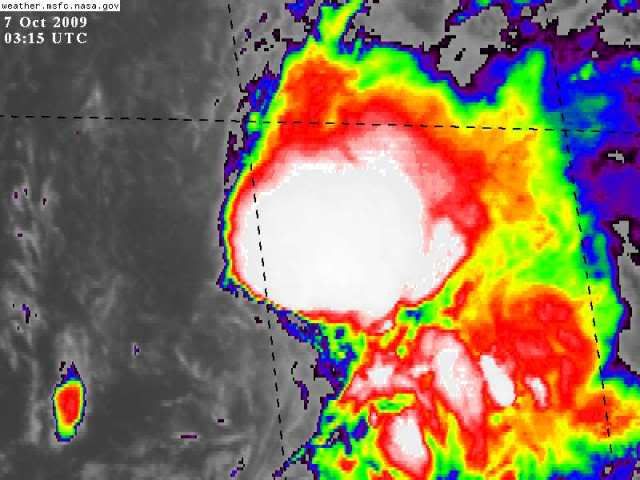
Re: ATL: TROPICAL STORM HENRI (10L)
Thats impressive..
4 Z image
everything else is in a eclipse..
actually here is last 2 images .. big explosion !

4 Z image
everything else is in a eclipse..
actually here is last 2 images .. big explosion !
0 likes
-
floridasun78
- Category 5
- Posts: 3755
- Joined: Sun May 17, 2009 10:16 pm
- Location: miami fl
Re: ATL: TROPICAL STORM HENRI (10L)
it like this ts henri not going by book i bet nhc will relook at henti later today have wind upto 60mph if this blowup near center keep growning
0 likes
-
cycloneye
- Admin

- Posts: 149519
- Age: 69
- Joined: Thu Oct 10, 2002 10:54 am
- Location: San Juan, Puerto Rico
Re: ATL: TROPICAL STORM HENRI - Advisories
WTNT35 KNHC 070843
TCPAT5
BULLETIN
TROPICAL STORM HENRI ADVISORY NUMBER 3
NWS TPC/NATIONAL HURRICANE CENTER MIAMI FL AL102009
500 AM AST WED OCT 07 2009
...HENRI STRENGTHENS A LITTLE MORE...
AT 500 AM AST...0900 UTC...THE CENTER OF TROPICAL STORM HENRI WAS
LOCATED NEAR LATITUDE 18.1 NORTH...LONGITUDE 56.1 WEST OR ABOUT 460
MILES...740 KM...EAST OF THE NORTHERN LEEWARD ISLANDS.
HENRI IS MOVING TOWARD THE WEST NEAR 14 MPH...22 KM/HR...AND A
WESTWARD TO WEST-NORTHWESTWARD MOTION IS EXPECTED TO CONTINUE OVER
THE NEXT DAY OR TWO. ON THIS TRACK...THE CENTER OF HENRI AND THE
ASSOCIATED STRONG WINDS ARE EXPECTED TO PASS NORTH OF THE LESSER
ANTILLES AT ITS CLOSEST APPROACH.
MAXIMUM SUSTAINED WINDS HAVE INCREASED TO NEAR 50 MPH...85 KM/HR...
WITH HIGHER GUSTS. LITTLE CHANGE IN STRENGTH IS EXPECTED TODAY.
HOWEVER...WEAKENING IS FORECAST TO BEGIN BY TONIGHT...AND HENRI
COULD BECOME A REMNANT LOW BY THURSDAY.
TROPICAL STORM FORCE WINDS EXTEND OUTWARD UP TO 70 MILES...110 KM
FROM THE CENTER.
ESTIMATED MINIMUM CENTRAL PRESSURE IS 1005 MB...29.68 INCHES.
...SUMMARY OF 500 AM AST INFORMATION...
LOCATION...18.1N 56.1W
MAXIMUM SUSTAINED WINDS...50 MPH
PRESENT MOVEMENT...WEST OR 280 DEGREES AT 13 MPH
MINIMUM CENTRAL PRESSURE...1005 MB
THE NEXT ADVISORY WILL BE ISSUED BY THE NATIONAL HURRICANE CENTER AT
1100 AM AST.
$$
FORECASTER KIMBERLAIN
000
WTNT45 KNHC 070848
TCDAT5
TROPICAL STORM HENRI DISCUSSION NUMBER 3
NWS TPC/NATIONAL HURRICANE CENTER MIAMI FL AL102009
500 AM AST WED OCT 07 2009
INFRARED SATELLITE IMAGERY AFTER THE ECLIPSE SHOWS A LARGE MASS OF
VIGOROUS DEEP CONVECTION ASSOCIATED WITH HENRI...WITH CLOUD TOP
TEMPERATURES COLDER THAN -80C. IN FACT...THE AREAL COVERAGE OF DEEP
CONVECTION HAS EXPANDED CONSIDERABLY SINCE YESTERDAY EVENING...
THOUGH THERE ARE NO BANDING FEATURES. HOWEVER...A 0531 UTC AMSR-E
PASS INDICATED THAT THE CENTER WAS STILL PARTIALLY EXPOSED...
LOCATED ON THE WESTERN EDGE OF THE MAIN CONVECTIVE CLUSTER. BASED
UPON THE IMPROVEMENT IN ORGANIZATION DURING THE PAST SEVERAL
HOURS...THE INITIAL INTENSITY IS RAISED TO 45 KT IN ACCORDANCE WITH
0600 UTC DVORAK CLASSIFICATIONS OF 3.0 FROM TAFB AND RECENT
OBJECTIVE ESTIMATES NEAR 3.0 FROM UW CIMSS.
PERSISTENT SOUTHWESTERLY SHEAR OF 20-25 KT CONTINUES TO PREVENT
HENRI FROM STRENGTHENING MUCH. SHIPS MODEL GUIDANCE INDICATES THAT
HIGH WESTERLY SHEAR SHOULD PREVAIL OVER HENRI FOR AT LEAST THE NEXT
24 HOURS...WITH A POSSIBLE RELAXATION THEREAFTER. THIS DOES NOT
SEEM ENTIRELY REALISTIC...AS A MAJORITY OF GLOBAL MODELS INDICATE
THAT HENRI SHOULD CROSS A SHARP SHEAR AXIS NORTH OF THE NORTHEAST
CARIBBEAN ISLANDS IN 36-48 HOURS AND ENCOUNTER STRONG UPPER-LEVEL
NORTHERLY OR NORTHEASTERLY FLOW. SHIPS MODEL OUTPUT ALSO FORECASTS
HENRI TO ENCOUNTER A CONVERGENT UPPER-LEVEL FLOW AND A RATHER
ANTICYCLONIC LOWER TROPOSPHERIC ENVIRONMENT...BOTH OF WHICH WOULD
HAVE A NEGATIVE INFLUENCE ON THE CYCLONE. GIVEN THESE FACTORS...THE
OFFICIAL FORECAST IS IN LINE WITH THE PREVIOUS ADVISORY AND A
MAJORITY OF LARGE-SCALE DYNAMICAL MODELS...CALLING FOR THE
DISSIPATION OF HENRI WITHIN 48 HOURS.
LATEST CENTER FIXES SUGGEST A RATHER UNCERTAIN INITIAL MOTION.
FORTUNATELY...A 0531 UTC AMSR-E PASS HAS ALLOWED FOR A MORE
CONFIDENT INITIAL MOTION ESTIMATE OF 280/11...FARTHER LEFT THAN IN
THE PREVIOUS ADVISORY. THE DOMINANT STEERING IS BEING PROVIDED BY
MID-LEVEL SUBTROPICAL RIDGING NORTH OF HENRI...WITH A MINOR
WEAKNESS AT UPPER LEVELS NORTHWEST OF THE CYCLONE. THIS FLOW
PATTERN SHOULD FAVOR A GENERALLY WESTWARD TO WEST-NORTHWESTWARD
TRACK UNTIL DISSIPATION. THE OFFICIAL FORECAST IS NUDGED SOUTH OF
THE PREVIOUS ADVISORY TO ACCOUNT FOR ITS MORE SOUTHERN INITIAL
POSITION AND MORE WESTERLY MOTION.
FORECAST POSITIONS AND MAX WINDS
INITIAL 07/0900Z 18.1N 56.1W 45 KT
12HR VT 07/1800Z 18.9N 58.0W 45 KT
24HR VT 08/0600Z 20.0N 60.3W 40 KT
36HR VT 08/1800Z 21.2N 62.5W 30 KT
48HR VT 09/0600Z 21.2N 63.2W 25 KT...REMNANT LOW
72HR VT 10/0600Z...DISSIPATED
$$
FORECASTER KIMBERLAIN
0 likes
Visit the Caribbean-Central America Weather Thread where you can find at first post web cams,radars
and observations from Caribbean basin members Click Here
and observations from Caribbean basin members Click Here
-
cycloneye
- Admin
- Posts: 149519
- Age: 69
- Joined: Thu Oct 10, 2002 10:54 am
- Location: San Juan, Puerto Rico
Re: ATL: TROPICAL STORM HENRI (10L)
It was going to be a short-lived cyclone per first advisory but here we are with Henri living another day.
0 likes
Visit the Caribbean-Central America Weather Thread where you can find at first post web cams,radars
and observations from Caribbean basin members Click Here
and observations from Caribbean basin members Click Here


Who is online
Users browsing this forum: No registered users and 35 guests