Looks like the LLC is being pulled into the convection and convection is beggining to pop over the LLC
http://metofis.rsmas.miami.edu/~dortt/satellite/invest_08/VIS/atl_vis1_loop.gif
ATL : TROPICAL DEPRESSION ERIKA (06L)
Moderator: S2k Moderators
-
Bocadude85

- Category 5

- Posts: 2991
- Age: 39
- Joined: Mon Apr 18, 2005 2:20 pm
- Location: Honolulu,Hi
-
MGC

- S2K Supporter

- Posts: 5940
- Joined: Sun Mar 23, 2003 9:05 pm
- Location: Pass Christian MS, or what is left.
Re: ATL : TROPICAL STORM ERIKA (06L)
Erika in the Caribbean....so much for my track north of the islands...throw that one out the window. What a fickle storm, that is what makes trying to figure these thing out so much fun. Yep, some convection near the center, lets see if it persists. Way things are going with Erika I would not be surprised if it tracks south of PR. At least it gives us something to track....its been a dud season......MGC
0 likes
-
Dave

- Retired Staff

- Posts: 13442
- Age: 75
- Joined: Tue Aug 01, 2006 3:57 pm
- Location: Milan Indiana
- Contact:
URNT15 KNHC 022158
AF309 0306A ERIKA HDOB 35 20090902
214830 1617N 06154W 8433 01570 0092 +180 +166 040007 007 024 000 00
214900 1616N 06154W 8428 01573 0091 +180 +165 044008 009 024 000 03
214930 1614N 06154W 8429 01572 0092 +179 +165 056009 009 025 000 03
215000 1612N 06154W 8429 01571 0091 +180 +165 060010 010 024 000 03
215030 1611N 06154W 8429 01573 0090 +181 +164 060010 011 999 999 03
215100 1609N 06154W 8430 01570 0092 +179 +164 054011 011 026 000 03
215130 1607N 06154W 8429 01572 0088 +181 +165 049012 012 026 000 03
215200 1605N 06154W 8430 01571 0087 +183 +166 047013 013 025 000 03
215230 1604N 06154W 8428 01571 0084 +185 +168 047011 013 025 000 03
215300 1602N 06154W 8430 01568 0083 +190 +170 038010 011 026 000 03
215330 1600N 06154W 8434 01567 0083 +189 +172 053008 010 025 000 03
215400 1559N 06153W 8430 01567 0084 +186 +175 109003 004 027 000 03
215430 1557N 06153W 8429 01569 0081 +189 +176 128001 002 027 000 03
215500 1556N 06152W 8430 01570 0081 +190 +177 224001 002 999 999 06
215530 1554N 06151W 8433 01569 9990 +191 +177 999999 999 999 999 36
215600 1553N 06152W 8429 01569 0084 +187 +178 223004 004 030 000 32
215630 1552N 06154W 8428 01570 0082 +188 +179 220003 004 032 000 00
215700 1551N 06155W 8429 01570 0080 +193 +179 261003 004 033 000 00
215730 1550N 06156W 8431 01569 0080 +190 +180 283004 004 033 000 03
215800 1549N 06158W 8429 01570 0082 +186 +180 298006 006 030 000 03
$$
;
0 likes
-
attallaman
Re: ATL : TROPICAL STORM ERIKA (06L)
Now aren't you glad it's been a dud season?MGC wrote:Erika in the Caribbean....so much for my track north of the islands...throw that one out the window. What a fickle storm, that is what makes trying to figure these thing out so much fun. Yep, some convection near the center, lets see if it persists. Way things are going with Erika I would not be surprised if it tracks south of PR. At least it gives us something to track....its been a dud season......MGC
0 likes

Re: ATL : TROPICAL STORM ERIKA (06L)
As the last visible frames of the day come in, I detect no westward movement whatsoever of the LLCC.
0 likes
-
BensonTCwatcher

- Category 5
- Posts: 1050
- Joined: Sat Aug 28, 2004 10:11 pm
- Location: Southport NC
Re:
deltadog03 wrote:I am wondering about that area up there as well wxman. That's the area I was pointing out earlier.
You can see pretty well in last of the visible loops that area referenced by WxMan (where recon located a low center) that is where the new center is forming. The old circ is collapsing. The fun continues 17.5N 60.5W
0 likes
-
OuterBanker
- S2K Supporter
- Posts: 1761
- Joined: Wed Feb 26, 2003 10:53 am
- Location: Nags Head, NC
- Contact:
-
Dave
- Retired Staff
- Posts: 13442
- Age: 75
- Joined: Tue Aug 01, 2006 3:57 pm
- Location: Milan Indiana
- Contact:
URNT15 KNHC 022208
AF309 0306A ERIKA HDOB 36 20090902
215830 1548N 06159W 8429 01569 0082 +185 +180 310008 008 026 001 00
215900 1547N 06200W 8429 01571 0082 +186 +180 312008 009 025 000 03
215930 1545N 06201W 8431 01568 0084 +185 +178 306010 011 024 000 00
220000 1544N 06203W 8425 01576 0084 +185 +177 300012 012 026 000 03
220030 1543N 06204W 8430 01569 0084 +187 +176 301013 013 024 000 03
220100 1542N 06205W 8431 01570 0085 +184 +175 305012 013 025 000 03
220130 1541N 06206W 8429 01572 0088 +182 +174 307011 011 024 000 03
220200 1540N 06208W 8429 01572 0091 +180 +174 314011 011 023 000 03
220230 1539N 06209W 8432 01568 0090 +179 +173 325010 011 027 002 00
220300 1538N 06210W 8435 01565 0098 +168 +168 319012 013 031 012 00
220330 1537N 06211W 8427 01573 0093 +176 +169 324012 013 026 000 00
220400 1536N 06213W 8432 01570 0090 +181 +165 321013 014 025 000 03
220430 1535N 06214W 8429 01574 0095 +176 +164 318014 016 029 004 00
220500 1533N 06215W 8438 01565 0094 +178 +163 305013 014 028 002 03
220530 1532N 06217W 8427 01574 0093 +180 +162 302016 016 027 000 00
220600 1531N 06218W 8432 01572 0092 +182 +162 307015 017 026 000 03
220630 1530N 06219W 8429 01573 0092 +183 +162 306013 014 026 000 00
220700 1529N 06220W 8428 01576 0093 +180 +163 312012 012 026 000 00
220730 1528N 06222W 8432 01572 0093 +180 +164 312013 013 026 000 03
220800 1527N 06223W 8429 01576 0095 +180 +165 312014 014 026 000 03
$$
;
0 likes
Re: ATL : TROPICAL STORM ERIKA (06L)
OK, I see the second area. In any case, it looks like somthing is pulling the old center eastward, and that doesn´t happen on its own.
0 likes
-
thetruesms

- Professional-Met

- Posts: 844
- Age: 42
- Joined: Thu Aug 16, 2007 1:14 pm
- Location: Tallahasee, FL
- Contact:
Re:
I wish we had time to get a few more visible shots of that area for my eyes to play more tricks on medeltadog03 wrote:I am wondering about that area up there as well wxman. That's the area I was pointing out earlier.
0 likes
-
Dave
- Retired Staff
- Posts: 13442
- Age: 75
- Joined: Tue Aug 01, 2006 3:57 pm
- Location: Milan Indiana
- Contact:
000
URNT12 KNHC 022212
VORTEX DATA MESSAGE AL062009
A. 02/21:54:30Z
B. 15 deg 58 min N
061 deg 53 min W
C. 850 mb 1497 m
D. 36 kt
E. 052 deg 171 nm
F. 148 deg 31 kt
G. 051 deg 236 nm
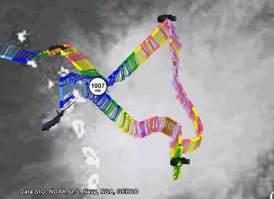
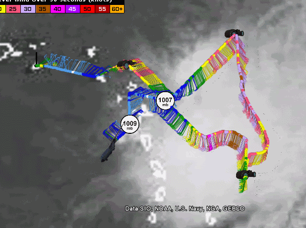
H. 1009 mb
I. 16 C / 1524 m
J. 19 C / 1523 m
K. 17 C / NA
L. NA
M. NA
N. 134 / 8
O. 0.05 / 3 nm
P. AF309 0306A ERIKA OB 06
MAX FL WIND 44 KT SE QUAD 18:22:30Z
;
URNT12 KNHC 022212
VORTEX DATA MESSAGE AL062009
A. 02/21:54:30Z
B. 15 deg 58 min N
061 deg 53 min W
C. 850 mb 1497 m
D. 36 kt
E. 052 deg 171 nm
F. 148 deg 31 kt
G. 051 deg 236 nm
H. 1009 mb
I. 16 C / 1524 m
J. 19 C / 1523 m
K. 17 C / NA
L. NA
M. NA
N. 134 / 8
O. 0.05 / 3 nm
P. AF309 0306A ERIKA OB 06
MAX FL WIND 44 KT SE QUAD 18:22:30Z
;
0 likes

Re:
Stormcenter wrote:I just got back from a long meeting and read the NHC discussion. I wouldn't bet too much on Erika doing too much more (as things look now) then a heavy rain maker. I cannot ever recall reading such a doom and gloom discussion from the NHC concerning any named tropical system. Erika like it's siblings is fighting a losing battle with shear. I personally cannot see any reason to argue any of their (NHC) points. This of course is just my opinion based on how things stand currently. By the way yes I do know that even a TS can cause death and destruction so I'm not down playing her potential.
Thank you.
You put it clearly and hope many read it.
The NHC rarely forecasts the demise of a system like this.
One that is racing out into the North Atlantic, yeah.
But not one in the tropics like this, in September; at the height of the season (I know 9/10 is statistically the "height" of the season).
So, Erika looks like toast as it relates to being a destructive wind storm.
But, as stormcenter put it, this is not to minimize the destruction that a rainmaker can be on The Islands.
This has the potential to be severe for the rain aspect as opposed to the wind of a hurricane.
Like Luis has said, waves and disturbed areas can be horrific for the islands for the flooding, mudslides and misery they can cause.
Good luck to our friends in The Islands.
For those here in Florida and GOM'ers, yes; this could be a problem down the road and, yes; there have been systems that have done so in the past; BUT; if this goes as the NHC predicts and is a remnant low in 5 days; you should direct your interests elsewhere.
Just my $.02
0 likes
-
SapphireSea
- Category 1

- Posts: 430
- Joined: Wed Aug 24, 2005 12:13 pm
- Location: Miami, FL
Re: ATL : TROPICAL STORM ERIKA (06L)
Around 18N and 56W I see some sort of ML or UL vort, I am not sure if it's some sort of sat mirage. This thing is a complete mess when it comes to system organization. I dont see anything that resembles another vort 17.5 and 60. I think this is just unorganized CAPE being expended, as I said a few days ago.
0 likes
-
Dave
- Retired Staff
- Posts: 13442
- Age: 75
- Joined: Tue Aug 01, 2006 3:57 pm
- Location: Milan Indiana
- Contact:
URNT15 KNHC 022218
AF309 0306A ERIKA HDOB 37 20090902
220830 1526N 06224W 8428 01575 0093 +180 +165 309013 013 025 000 03
220900 1525N 06225W 8432 01574 0095 +178 +166 298012 013 024 000 00
220930 1524N 06227W 8429 01574 0098 +175 +166 293012 012 025 000 03
221000 1523N 06228W 8429 01576 0099 +174 +166 295012 012 023 000 03
221030 1522N 06229W 8432 01575 0097 +175 +165 290012 013 999 999 03
221100 1521N 06230W 8429 01575 0094 +180 +164 284012 014 029 000 03
221130 1519N 06232W 8429 01577 0095 +182 +164 293013 013 016 000 03
221200 1518N 06233W 8433 01574 0097 +181 +164 288012 013 022 000 03
221230 1517N 06234W 8428 01583 0102 +176 +164 284012 013 999 999 03
221300 1516N 06233W 8432 01577 0102 +177 +165 267013 013 999 999 03
221330 1515N 06231W 8430 01578 0098 +179 +165 268015 015 999 999 03
221400 1515N 06230W 8428 01578 0098 +180 +165 261016 016 014 002 00
221430 1515N 06228W 8430 01578 0100 +175 +165 253016 016 014 002 00
221500 1515N 06226W 8430 01577 0102 +175 +164 252017 017 019 000 00
221530 1514N 06224W 8431 01576 0104 +174 +163 254015 015 019 002 00
221600 1514N 06222W 8425 01584 0102 +176 +163 257015 015 019 002 00
221630 1514N 06220W 8433 01576 0101 +179 +162 252016 017 020 002 00
221700 1514N 06219W 8431 01579 0101 +175 +161 244018 018 024 000 03
221730 1514N 06217W 8422 01586 0102 +175 +161 245017 018 025 000 03
221800 1513N 06215W 8433 01577 0104 +174 +161 245018 019 025 000 00
$$
;
0 likes
-
Bocadude85
- Category 5
- Posts: 2991
- Age: 39
- Joined: Mon Apr 18, 2005 2:20 pm
- Location: Honolulu,Hi
Re: ATL : TROPICAL STORM ERIKA - Computer Models
18z GFS wave makes landfall in S Fl in 6days
http://www.nco.ncep.noaa.gov/pmb/nwprod/analysis/namer/gfs/18/images/gfs_ten_132l.gif
http://www.nco.ncep.noaa.gov/pmb/nwprod/analysis/namer/gfs/18/images/gfs_ten_132l.gif
0 likes
-
paintplaye
- Category 1
- Posts: 380
- Joined: Sun Jul 20, 2008 11:25 pm
Re: ATL : TROPICAL STORM ERIKA (06L)
Watch convection is going to come back and we are going to have the same posts as last night; "This is such an impressive storm". Then it is going to die off and the cycle will continue. 
0 likes
-
SapphireSea
- Category 1
- Posts: 430
- Joined: Wed Aug 24, 2005 12:13 pm
- Location: Miami, FL
Re: ATL : TROPICAL STORM ERIKA (06L)
paintplaye wrote:Watch convection is going to come back and we are going to have the same posts as last night; "This is such an impressive storm". Then it is going to die off and the cycle will continue.
Unless it develops an eye or pulls a real consistant moving center on Microwave, it won't matter how much convection it creates. Regardless, this is not good for the islands. We will see what happens.
0 likes
-
Dave
- Retired Staff
- Posts: 13442
- Age: 75
- Joined: Tue Aug 01, 2006 3:57 pm
- Location: Milan Indiana
- Contact:
URNT15 KNHC 022228
AF309 0306A ERIKA HDOB 38 20090902
221830 1513N 06213W 8425 01584 0105 +174 +160 245020 021 027 000 00
221900 1513N 06211W 8435 01576 0107 +173 +159 244020 021 028 004 00
221930 1513N 06210W 8426 01584 0108 +171 +158 244019 021 030 004 00
222000 1513N 06208W 8440 01570 0106 +175 +157 242017 017 029 002 00
222030 1512N 06206W 8427 01583 0107 +175 +155 241017 017 027 000 03
222100 1512N 06204W 8430 01580 0107 +175 +155 243017 018 024 000 00
222130 1512N 06202W 8429 01582 0108 +175 +155 242018 018 025 000 03
222200 1512N 06200W 8428 01582 0111 +171 +156 244018 019 029 006 00
222230 1512N 06159W 8450 01561 0111 +170 +157 240018 018 029 008 00
222300 1512N 06157W 8422 01589 0107 +173 +156 241019 020 025 000 00
222330 1511N 06155W 8430 01582 0108 +172 +155 242019 019 026 000 03
222400 1511N 06153W 8428 01583 0112 +166 +155 238021 022 025 001 00
222430 1511N 06151W 8433 01579 0110 +168 +155 234018 019 026 000 00
222500 1511N 06150W 8430 01580 0108 +172 +152 233020 020 025 000 03
222530 1511N 06150W 8430 01580 0104 +179 +150 226021 021 024 000 03
222600 1510N 06146W 8433 01578 0102 +182 +148 223021 021 023 000 03
222630 1510N 06144W 8429 01584 0106 +175 +149 227021 021 024 000 03
222700 1510N 06142W 8432 01579 0106 +175 +152 222022 023 024 000 03
222730 1510N 06141W 8426 01585 0103 +180 +153 220023 023 025 000 03
222800 1510N 06139W 8430 01581 0103 +182 +153 219022 022 025 000 03
$$
;
0 likes
Who is online
Users browsing this forum: No registered users and 70 guests