ATL : TROPICAL DEPRESSION ERIKA (06L)

Moderator: S2k Moderators

Message
Author
User avatar
storms NC
Tropical Storm
Tropical Storm
Posts: 247
Age: 69
Joined: Tue Sep 14, 2004 2:41 pm
Location: Coast of NC & southwest coast of Fla

Re: ATL : TROPICAL STORM ERIKA (06L)

#3541 Postby storms NC » Wed Sep 02, 2009 6:09 pm

lrak wrote:GOM, WTH are you guys talking about? I thought this was Florida or East Coast event if anything at all. Mexico? :double:

I saw a few days ago the LBAR having this thing cruise towards MEX but someone said the LBAR is on crack.


I don't see how there is going to be a high in the Gulf un less it don't make it.
0 likes   

User avatar
Dave
Retired Staff
Retired Staff
Posts: 13442
Age: 74
Joined: Tue Aug 01, 2006 3:57 pm
Location: Milan Indiana
Contact:

#3542 Postby Dave » Wed Sep 02, 2009 6:10 pm

URNT15 KNHC 022308
AF309 0306A ERIKA HDOB 42 20090902
225830 1553N 06144W 8433 01578 0098 +186 +160 170012 013 025 002 00
225900 1553N 06146W 8429 01581 0098 +186 +160 169012 014 027 002 00
225930 1554N 06148W 8425 01585 0098 +186 +162 159010 011 028 001 03
230000 1555N 06149W 8432 01578 0094 +189 +163 157006 007 027 001 00
230030 1555N 06149W 8432 01578 0091 +193 +164 118005 006 027 001 00
230100 1555N 06153W 8434 01574 0090 +193 +165 102005 006 028 002 00
230130 1555N 06154W 8429 01577 0089 +195 +167 100007 007 028 000 00
230200 1556N 06156W 8432 01574 0088 +195 +168 081006 006 024 000 03
230230 1555N 06158W 8426 01579 0087 +192 +169 055004 005 021 001 00
230300 1555N 06200W 8434 01566 0084 +190 +170 057006 006 011 002 00
230330 1555N 06202W 8428 01572 0084 +187 +171 054010 012 004 002 00
230400 1555N 06203W 8430 01572 0085 +188 +171 056013 014 006 002 03
230430 1556N 06205W 8423 01581 0086 +190 +171 068013 014 009 002 03
230500 1557N 06206W 8432 01572 0088 +190 +171 067014 015 011 002 00
230530 1558N 06207W 8429 01579 0090 +190 +171 062013 013 016 001 00
230600 1600N 06209W 8429 01578 0090 +192 +170 057014 015 013 002 00
230630 1601N 06210W 8282 01733 0090 +184 +170 047013 014 018 001 03
230700 1602N 06211W 7888 02152 0086 +168 +168 042012 013 999 999 03
230730 1603N 06212W 7554 02520 0078 +150 +150 046012 013 999 999 03
230800 1605N 06214W 7209 02916 9990 +129 +999 026014 015 999 999 05
$$
;
0 likes   

User avatar
Dave
Retired Staff
Retired Staff
Posts: 13442
Age: 74
Joined: Tue Aug 01, 2006 3:57 pm
Location: Milan Indiana
Contact:

#3543 Postby Dave » Wed Sep 02, 2009 6:20 pm

URNT15 KNHC 022318
AF309 0306A ERIKA HDOB 43 20090902
230830 1606N 06215W 6902 03285 9990 +115 +999 031014 016 999 999 05
230900 1607N 06216W 6631 03626 9990 +094 +999 041017 017 999 999 05
230930 1608N 06217W 6374 03954 9990 +067 +999 042015 016 999 999 05
231000 1610N 06219W 6134 04271 9990 +044 +999 047013 014 999 999 05
231030 1611N 06220W 5909 04558 9990 +022 +999 045011 012 999 999 05
231100 1612N 06221W 5704 04839 9990 +002 +999 053010 011 999 999 05
231130 1614N 06222W 5500 05149 9990 -016 +999 038013 014 999 999 05
231200 1615N 06224W 5299 05445 0305 -025 +999 030017 017 999 999 05
231230 1616N 06225W 5128 05704 0321 -042 +999 030014 018 999 999 05
231300 1617N 06226W 5053 05824 0326 -052 +999 033012 012 016 001 01
231330 1619N 06228W 5054 05819 0324 -053 +999 032013 013 020 000 01
231400 1621N 06230W 5054 05819 0323 -050 +999 032014 014 017 001 01
231430 1623N 06231W 5056 05811 0323 -050 +999 032015 015 020 000 01
231500 1624N 06233W 5057 05815 0324 -050 -050 031015 015 019 000 00
231530 1626N 06235W 5058 05815 0326 -046 -046 032015 016 020 000 00
231600 1628N 06237W 5058 05815 0326 -047 -052 037017 017 021 000 00
231630 1630N 06239W 5064 05805 0327 -050 -056 036016 016 022 000 00
231700 1632N 06241W 5058 05820 0328 -050 -057 039015 016 024 000 03
231730 1634N 06243W 5059 05815 0329 -050 -058 038014 014 999 999 03
231800 1636N 06245W 5058 05823 0329 -050 -059 035015 015 999 999 03
$$
;
0 likes   

User avatar
Dave
Retired Staff
Retired Staff
Posts: 13442
Age: 74
Joined: Tue Aug 01, 2006 3:57 pm
Location: Milan Indiana
Contact:

#3544 Postby Dave » Wed Sep 02, 2009 6:21 pm

000
UZNT13 KNHC 022208
XXAA 52228 99159 70619 04351 99009 26813 18516 00082 26207 17516
92768 22805 18012 85505 19411 18501 88999 77999
31313 09608 82154
61616 AF309 0306A ERIKA OB 07
62626 SPL 1595N06187W 2156 MBL WND 18017 AEV 20801 DLM WND 18011
009843 WL150 17516 083 REL 1594N06187W 215449 SPG 1595N06187W 215
638 =
XXBB 52228 99159 70619 04351 00009 26813 11850 19411 22843 19013
21212 00009 18516 11995 17016 22958 18019 33888 18006 44874 19506
55843 00000
31313 09608 82154
61616 AF309 0306A ERIKA OB 07
62626 SPL 1595N06187W 2156 MBL WND 18017 AEV 20801 DLM WND 18011
009843 WL150 17516 083 REL 1594N06187W 215449 SPG 1595N06187W 215
638 =
;
0 likes   

User avatar
jasons2k
Storm2k Executive
Storm2k Executive
Posts: 8245
Age: 51
Joined: Wed Jul 06, 2005 12:32 pm
Location: The Woodlands, TX

Re: Re:

#3545 Postby jasons2k » Wed Sep 02, 2009 6:22 pm

Aric Dunn wrote:
sorry not the right link


That's OK, I found a new avatar :-)
0 likes   

User avatar
Dave
Retired Staff
Retired Staff
Posts: 13442
Age: 74
Joined: Tue Aug 01, 2006 3:57 pm
Location: Milan Indiana
Contact:

#3546 Postby Dave » Wed Sep 02, 2009 6:26 pm

000
URNT12 KNHC 022324
VORTEX DATA MESSAGE AL062009
A. 02/23:03:40Z
B. 15 deg 55 min N
062 deg 02 min W
C. 850 mb 1499 m
D. 28 kt
E. 108 deg 30 nm
F. 213 deg 21 kt
G. 124 deg 67 nm
H. 1010 mb
I. 17 C / 1524 m
J. 20 C / 1525 m
K. 17 C / NA
L. NA
M. NA
N. 134 / 8
O. 0.02 / 4 nm
P. AF309 0306A ERIKA OB 10
MAX FL WIND 36 KT E QUAD 20:03:00Z
;
0 likes   

User avatar
jasons2k
Storm2k Executive
Storm2k Executive
Posts: 8245
Age: 51
Joined: Wed Jul 06, 2005 12:32 pm
Location: The Woodlands, TX

#3547 Postby jasons2k » Wed Sep 02, 2009 6:29 pm

I saw earlier today soundings from Guadalupe and from San Juan. They were very different. The Guadalupe sounding showed an area of shear and dry air intrusion. It was an "unfavorable" sounding just looking at it.

The one form San Juan was much different. Just a moist, tropical sounding. It didn't show the dry air intrusion.

Just something to think about as Erika moves to the west.
0 likes   

User avatar
Dave
Retired Staff
Retired Staff
Posts: 13442
Age: 74
Joined: Tue Aug 01, 2006 3:57 pm
Location: Milan Indiana
Contact:

#3548 Postby Dave » Wed Sep 02, 2009 6:30 pm

URNT15 KNHC 022328
AF309 0306A ERIKA HDOB 44 20090902
231830 1638N 06247W 5060 05817 0329 -050 -061 035015 016 999 999 03
231900 1640N 06249W 5058 05818 0329 -050 -063 033016 017 025 000 03
231930 1642N 06251W 5059 05816 0329 -047 -065 037017 018 022 000 00
232000 1644N 06253W 5057 05814 0329 -046 -066 039018 018 023 000 00
232030 1646N 06255W 5060 05816 0329 -045 -067 039018 018 023 000 00
232100 1648N 06257W 5060 05814 0327 -043 -067 041019 020 020 000 00
232130 1650N 06259W 5058 05819 0329 -040 -069 044021 022 020 001 00
232200 1652N 06301W 5060 05815 0330 -045 -070 042019 020 022 000 00
232230 1654N 06303W 5060 05813 0329 -043 -071 046021 021 023 000 00
232300 1656N 06305W 5060 05815 0330 -045 -073 046020 020 022 000 00
232330 1658N 06307W 5103 05750 0329 -042 -074 033019 019 014 001 03
232400 1700N 06310W 5252 05521 0313 -027 -077 027018 018 999 999 03
232430 1701N 06312W 5426 05261 0294 -010 -074 026018 018 999 999 03
232500 1702N 06315W 5633 04958 0088 +013 -072 024016 017 999 999 03
232530 1702N 06315W 5633 04958 0088 +026 -068 023011 013 999 999 03
232600 1703N 06319W 6041 04399 0128 +028 -057 056009 009 999 999 03
232630 1704N 06321W 6252 04118 0130 +047 -045 041012 015 999 999 03
232700 1705N 06324W 6476 03828 0137 +059 -034 048016 016 999 999 03
232730 1706N 06326W 6672 03583 0132 +074 -022 060016 017 023 000 03
232800 1707N 06328W 6684 03563 0127 +075 -009 057017 018 022 001 00
$$
;

Mission's Over
0 likes   

lonelymike
S2K Supporter
S2K Supporter
Posts: 634
Joined: Sat Jul 26, 2008 10:12 am
Location: walton county fla

Re:

#3549 Postby lonelymike » Wed Sep 02, 2009 6:31 pm

AdamFirst wrote:One of my local TV mets has given the proverbial "all-clear"...said Erika is nothing to worry about.


Yeah and they'll joining Bob Breck in running for their lives in the swamps of S La if this pulls a Katrina :grrr: :cheesy:
0 likes   

User avatar
Dave
Retired Staff
Retired Staff
Posts: 13442
Age: 74
Joined: Tue Aug 01, 2006 3:57 pm
Location: Milan Indiana
Contact:

#3550 Postby Dave » Wed Sep 02, 2009 6:33 pm

Image
0 likes   

fasterdisaster
Category 5
Category 5
Posts: 1868
Joined: Mon Sep 19, 2005 4:41 pm
Location: Miami, Florida

#3551 Postby fasterdisaster » Wed Sep 02, 2009 6:33 pm

The NHC advisory should say: All interests from Costa Rica to Newfoundland should closely monitor Erika
0 likes   

User avatar
knotimpaired
Category 1
Category 1
Posts: 495
Joined: Fri May 20, 2005 4:14 am
Location: Vieques, PR
Contact:

#3552 Postby knotimpaired » Wed Sep 02, 2009 6:34 pm

This came out a few hours ago.


Captain of the Port sets Port Condition YANKEE for the U.S. Virgin Islands
“Tropical Storm Erika Update 2"

SAN JUAN, Puerto Rico – The Coast Guard Sector San Juan Captain of the Port, Capt. Eduardo Pino, set Port Condition YANKEE Wednesday at 6p.m. for all the ports in Saint Croix and at 8p.m. for all the ports in Saint John and Saint Thomas, U.S. Virgin Islands due to the expectation that gale force winds generated by Tropical Storm Erika will arrive within 24 hours.
Ferry operations in the U.S. Virgin Islands are allowed during Port Condition YANKEE.

The ports in Puerto Rico remain at Port Condition X-RAY subject to changes in Erika's storm track or strength.

"WARNING"
During Port Condition YANKEE all ports are closed to inbound vessel traffic greater than 200 Gross Tons. All vessels greater than 200 gross tons without permission to remain in port should have departed or be prepared to depart prior to the setting of Port Condition ZULU.
During Port Condition X-RAY waterfront facilities should be removing potential flying debris, hazardous materials and pollutants from dockside areas. All oceangoing commercial vessels greater than 200 gross tons must prepare to depart the port and shall depart immediately upon setting and increasing port conditions to YANKEE. Vessels unable to depart the port must contact the Captain of the Port and submit a safe mooring plan in writing when requesting and prior to receiving permission to remain in port. Inbound vessels that will be unable to depart the port upon the setting of port condition YANKEE are advised to seek an alternate destination.
0 likes   

User avatar
Dave
Retired Staff
Retired Staff
Posts: 13442
Age: 74
Joined: Tue Aug 01, 2006 3:57 pm
Location: Milan Indiana
Contact:

#3553 Postby Dave » Wed Sep 02, 2009 6:34 pm

FLIGHT TWO - TEAL 75......NO CHANGE
A. 03/0600Z, 1200Z
B. AFXXX 0406A CYCLONE
C. 03/0445Z
D. 18.5N 62.2W
E. 03/0530Z TO 03/1200Z
F. SFC TO 10,000 FT
0 likes   

User avatar
cycloneye
Admin
Admin
Posts: 145374
Age: 68
Joined: Thu Oct 10, 2002 10:54 am
Location: San Juan, Puerto Rico

Re: ATL: TROPICAL STORM ERIKA Advisories Thread

#3554 Postby cycloneye » Wed Sep 02, 2009 6:38 pm

000
WTNT31 KNHC 022336
TCPAT1
BULLETIN
TROPICAL STORM ERIKA INTERMEDIATE ADVISORY NUMBER 5A
NWS TPC/NATIONAL HURRICANE CENTER MIAMI FL AL062009
800 PM AST WED SEP 02 2009

...ERIKA BARELY A TROPICAL STORM...WILL LIKELY WEAKEN FURTHER
TONIGHT...

A TROPICAL STORM WARNING IS IN EFFECT FOR DOMINICA...GUADELOUPE...
ST. MARTIN...ST. BARTHELEMY...ANTIGUA...BARBUDA...MONTSERRAT...ST.
KITTS...NEVIS...ANGUILLA...ST. MAARTEN...SABA...AND ST. EUSTATIUS.

A TROPICAL STORM WATCH REMAINS IN EFFECT FOR PUERTO RICO...THE U.S.
AND THE BRITISH VIRGIN ISLANDS.

INTERESTS IN THE DOMINICAN REPUBLIC AND HAITI SHOULD MONITOR THE
PROGRESS OF ERIKA.

FOR STORM INFORMATION SPECIFIC TO YOUR AREA IN THE UNITED
STATES...INCLUDING POSSIBLE INLAND WATCHES AND WARNINGS...PLEASE
MONITOR PRODUCTS ISSUED BY YOUR LOCAL NATIONAL WEATHER SERVICE
FORECAST OFFICE. FOR STORM INFORMATION SPECIFIC TO YOUR AREA
OUTSIDE OF THE UNITED STATES...PLEASE MONITOR PRODUCTS ISSUED
BY YOUR NATIONAL METEOROLOGICAL SERVICE.

AT 800 PM AST...0000 UTC...THE CENTER OF POORLY ORGANIZED TROPICAL
STORM ERIKA WAS ESTIMATED NEAR LATITUDE 15.9 NORTH...LONGITUDE 62.0
WEST...OR JUST WEST OF GUADELOUPE AND ABOUT 315 MILES...510 KM...
SOUTHEAST OF SAN JUAN PUERTO RICO.

ERIKA HAS BEEN DRIFTING BETWEEN THE WEST AND WEST-SOUTHWEST DURING
THE PAST FEW HOURS BUT IT SHOULD RESUME A WESTWARD MOTION NEAR 10
MPH...17 KM/HR LATER TONIGHT. A WEST-NORTHWESTWARD MOTION IS
EXPECTED TO BEGIN EARLY TOMORROW. ON THE FORECAST TRACK...THE
WEATHER ASSOCIATED WITH ERIKA WILL CONTINUE TO MOVE THROUGH THE
LEEWARD ISLANDS TONIGHT AND APPROACH PUERTO RICO LATE TOMORROW.

MAXIMUM SUSTAINED WINDS ARE NEAR 40 MPH...65 KM/HR...WITH HIGHER
GUSTS. LITTLE CHANGE IN STRENGTH IS EXPECTED TONIGHT AND ERIKA
COULD WEAKEN TO A TROPICAL DEPRESSION TONIGHT OR THURSDAY.

TROPICAL STORM FORCE WINDS EXTEND OUTWARD UP TO 205 MILES...335 KM
PRIMARILY TO THE EAST OF THE CENTER.

THE ESTIMATED MINIMUM CENTRAL PRESSURE IS 1008 MB...29.77 INCHES.

ERIKA IS EXPECTED TO PRODUCE TOTAL RAINFALL ACCUMULATIONS OF 2 TO 4
INCHES OVER MUCH OF THE LESSER ANTILLES DURING THE NEXT COUPLE OF
DAYS...WITH ISOLATED MAXIMUM AMOUNTS OF 6 INCHES POSSIBLE. OVER
PUERTO RICO...3 TO 5 INCHES OF RAIN ARE POSSIBLE DURING THE NEXT
FEW DAYS...WITH ISOLATED MAXIMUM AMOUNTS OF 8 INCHES.

...SUMMARY OF 800 PM AST INFORMATION...
LOCATION...15.9N 62.0W
MAXIMUM SUSTAINED WINDS...40 MPH
PRESENT MOVEMENT...WEST OR 260 DEGREES AT 1 MPH
MINIMUM CENTRAL PRESSURE...1008 MB

THE NEXT ADVISORY WILL BE ISSUED BY THE NATIONAL HURRICANE CENTER AT
1100 PM AST.

$$
FORECASTER AVILA
0 likes   

User avatar
cycloneye
Admin
Admin
Posts: 145374
Age: 68
Joined: Thu Oct 10, 2002 10:54 am
Location: San Juan, Puerto Rico

Re: ATL : TROPICAL STORM ERIKA (06L)

#3555 Postby cycloneye » Wed Sep 02, 2009 6:41 pm

This is from the 8 PM advisory,They expect Erika to weaken to a TD later tonight or early tommorow.

MAXIMUM SUSTAINED WINDS ARE NEAR 40 MPH...65 KM/HR...WITH HIGHER
GUSTS. LITTLE CHANGE IN STRENGTH IS EXPECTED TONIGHT AND ERIKA
COULD WEAKEN TO A TROPICAL DEPRESSION TONIGHT OR THURSDAY.
0 likes   

User avatar
Gustywind
Category 5
Category 5
Posts: 12334
Joined: Mon Sep 03, 2007 7:29 am
Location: Baie-Mahault, GUADELOUPE

Re: Re:

#3556 Postby Gustywind » Wed Sep 02, 2009 6:43 pm

knotimpaired wrote:
Gustywind wrote:ERIKA is coming in Guadeloupe.... :roll: :oops:

Image


Take care Gusty. Let us know how things are going if you can.

K

Yeah my friend, i will try as possible :) Tkanks knotimpaired :wink:
0 likes   

User avatar
Evil Jeremy
S2K Supporter
S2K Supporter
Posts: 5463
Age: 32
Joined: Mon Apr 10, 2006 2:10 pm
Location: Los Angeles, CA

Re: ATL : TROPICAL STORM ERIKA (06L)

#3557 Postby Evil Jeremy » Wed Sep 02, 2009 6:44 pm

cycloneye wrote:This is from the 8 PM advisory,They expect Erika to weaken to a TD later tonight or early tommorow.

MAXIMUM SUSTAINED WINDS ARE NEAR 40 MPH...65 KM/HR...WITH HIGHER
GUSTS. LITTLE CHANGE IN STRENGTH IS EXPECTED TONIGHT AND ERIKA
COULD WEAKEN TO A TROPICAL DEPRESSION TONIGHT OR THURSDAY.


I am not sure that they "expect" it. They say it is a possibility, but it would say "Erika is expected to weaken..." if they expected it lol.
0 likes   

User avatar
cycloneye
Admin
Admin
Posts: 145374
Age: 68
Joined: Thu Oct 10, 2002 10:54 am
Location: San Juan, Puerto Rico

Re: ATL : TROPICAL STORM ERIKA (06L)

#3558 Postby cycloneye » Wed Sep 02, 2009 6:48 pm

Evil Jeremy wrote:
cycloneye wrote:This is from the 8 PM advisory,They expect Erika to weaken to a TD later tonight or early tommorow.

MAXIMUM SUSTAINED WINDS ARE NEAR 40 MPH...65 KM/HR...WITH HIGHER
GUSTS. LITTLE CHANGE IN STRENGTH IS EXPECTED TONIGHT AND ERIKA
COULD WEAKEN TO A TROPICAL DEPRESSION TONIGHT OR THURSDAY.


I am not sure that they "expect" it. They say it is a possibility, but it would say "Erika is expected to weaken..." if they expected it lol.


If you read the past discussions,they haved been laying the foundation for the obituary.
0 likes   

Chris_in_Tampa
Category 5
Category 5
Posts: 5075
Age: 41
Joined: Thu Jun 21, 2007 11:06 pm
Location: Tampa, Florida, USA
Contact:

#3559 Postby Chris_in_Tampa » Wed Sep 02, 2009 6:52 pm

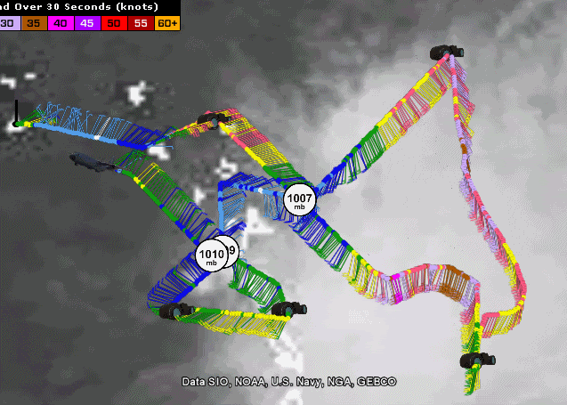
Today's mission with the vortex missions from the previous two mission plotted as well:
Image
Satellite imagery from NRL's Google Earth file: http://www.nrlmry.navy.mil/tcdat/tc09/A ... L.main.kml
0 likes   

Dean4Storms
S2K Supporter
S2K Supporter
Posts: 6358
Age: 62
Joined: Sun Aug 31, 2003 1:01 pm
Location: Miramar Bch. FL

#3560 Postby Dean4Storms » Wed Sep 02, 2009 6:58 pm

I wouldn't totally rule Erika out yet, we've seen storms come roaring back. I think we are going to have to watch this once it gets into the FL Straits with whatever energy remains of it.
0 likes   


Return to “2009”

Who is online

Users browsing this forum: No registered users and 7 guests