
URNT15 KNHC 042216
AF303 0111A CYCLONE HDOB 43 20091104
220630 1306N 08243W 9248 00763 0092 +201 +196 092039 040 020 000 00
220700 1308N 08243W 9244 00769 0094 +201 +195 089038 039 021 000 00
220730 1309N 08243W 9241 00769 0094 +200 +200 088036 038 027 000 03
220800 1311N 08243W 9248 00764 0094 +200 +200 090037 039 023 002 00
220830 1312N 08243W 9250 00762 0092 +200 +200 091039 039 024 002 00
220900 1314N 08243W 8962 01018 0077 +187 +184 092039 040 999 999 03
220930 1316N 08243W 8576 01406 0085 +165 +162 096040 041 021 000 03
221000 1318N 08244W 8278 01707 0085 +148 +148 096037 038 999 999 03
221030 1319N 08244W 7923 02082 0085 +129 +129 099036 037 021 001 03
221100 1321N 08244W 7600 02445 0093 +114 +114 101032 033 021 000 03
221130 1323N 08244W 7303 02778 0084 +107 +077 109029 031 022 000 00
221200 1325N 08244W 7071 03047 0080 +095 +050 113032 033 022 000 00
221230 1327N 08245W 6818 03348 0083 +072 +044 108033 034 021 000 03
221300 1329N 08245W 6555 03672 0080 +053 +050 100034 035 021 000 03
221330 1332N 08245W 6322 03969 0080 +035 +034 100033 034 022 000 00
221400 1334N 08245W 6111 04244 0075 +021 +020 096031 034 021 000 00
221430 1336N 08246W 5894 04535 0067 +007 +007 088034 034 018 000 00
221500 1338N 08246W 5705 04797 0044 +003 -001 079032 032 021 000 03
221530 1340N 08246W 5548 05019 0042 -010 -014 080033 034 024 001 00
221600 1342N 08246W 5418 05209 0234 -019 -019 079033 034 029 005 00
$$
;
Mission over.
ATL : TROPICAL DEPRESSION IDA
Moderator: S2k Moderators


Re: ATL : TROPICAL STORM IDA - Models
Tampa? that would a bad scenario if it was a strong storm. Doesnt take much of a surge there...
0 likes
-
Ivanhater

- Storm2k Moderator

- Posts: 11222
- Age: 39
- Joined: Fri Jul 01, 2005 8:25 am
- Location: Pensacola
Re: ATL : TROPICAL STORM IDA - Models
156 hrs
seems to stall then move east some..trough might pick it up

seems to stall then move east some..trough might pick it up
0 likes
Michael
-
cycloneye

- Admin

- Posts: 149735
- Age: 69
- Joined: Thu Oct 10, 2002 10:54 am
- Location: San Juan, Puerto Rico
Re: ATL : TROPICAL STORM IDA - Recon
Next mission will be tommorow afternoon.It may not happen if it makes landfall.
A. 05/1800Z
B. AFXXX 0211A CYCLONE
C. 05/1230Z
D. 12.7N 83.2W
E. 05/1630Z TO 05/2030Z
F. SFC TO 10,000 FT
A. 05/1800Z
B. AFXXX 0211A CYCLONE
C. 05/1230Z
D. 12.7N 83.2W
E. 05/1630Z TO 05/2030Z
F. SFC TO 10,000 FT
0 likes
Visit the Caribbean-Central America Weather Thread where you can find at first post web cams,radars
and observations from Caribbean basin members Click Here
and observations from Caribbean basin members Click Here
-
srainhoutx

- S2K Supporter

- Posts: 6919
- Age: 68
- Joined: Sun Jan 14, 2007 11:34 am
- Location: Haywood County, NC
- Contact:
Re: ATL : TROPICAL STORM IDA
0 likes
Carla/Alicia/Jerry(In The Eye)/Michelle/Charley/Ivan/Dennis/Katrina/Rita/Wilma/Ike/Harvey
Member: National Weather Association
Wx Infinity Forums
http://wxinfinity.com/index.php
Facebook.com/WeatherInfinity
Twitter @WeatherInfinity
Member: National Weather Association
Wx Infinity Forums
http://wxinfinity.com/index.php
Facebook.com/WeatherInfinity
Twitter @WeatherInfinity
-
Ivanhater
- Storm2k Moderator
- Posts: 11222
- Age: 39
- Joined: Fri Jul 01, 2005 8:25 am
- Location: Pensacola
Re: ATL : TROPICAL STORM IDA - Models
18z gfs stalls Ida in the gulf then pushes her back south similar to the Euro
0 likes
Michael
-
cycloneye
- Admin
- Posts: 149735
- Age: 69
- Joined: Thu Oct 10, 2002 10:54 am
- Location: San Juan, Puerto Rico
Re: ATL : TROPICAL STORM IDA - Models
Ivanhater wrote:18z gfs stalls Ida in the gulf then pushes her back south similar to the Euro
So the EURO is not alone,and I was mocking that model earlier.
0 likes
Visit the Caribbean-Central America Weather Thread where you can find at first post web cams,radars
and observations from Caribbean basin members Click Here
and observations from Caribbean basin members Click Here
Re: ATL : TROPICAL STORM IDA - Models
it misses the trof? oh brother.... 
I was mocking the EURO also....
I was mocking the EURO also....
0 likes
-
Hurricanewatcher2007

- Category 2

- Posts: 578
- Joined: Sat Jul 05, 2008 8:10 pm
Re: ATL : TROPICAL STORM IDA
000
WTNT61 KNHC 042230
TCUAT1
TROPICAL STORM IDA TROPICAL CYCLONE UPDATE
NWS TPC/NATIONAL HURRICANE CENTER MIAMI FL AL112009
530 PM EST WED NOV 04 2009
...IDA A LITTLE STRONGER...HURRICANE WATCH ISSUED...
AT 530 PM EST...2230 UTC...THE GOVERNMENT OF NICARAGUA HAS ISSUED A
HURRICANE WATCH FOR THE EASTERN COAST OF NICARAGUA FROM BLUEFIELDS
NORTHWARD TO THE HONDURAS/NICARAGUA BORDER. A TROPICAL STORM
WARNING REMAINS IN EFFECT FOR THE ENTIRE EASTERN COAST OF NICARAGUA
AND FOR THE ISLANDS OF SAN ANDRES AND PROVIDENCIA.
REPORTS FROM AN AIR FORCE RESERVE RECONNAISSANCE PLANE INVESTIGATING
IDA INDICATE THAT THE MAXIMUM SUSTAINED WINDS HAVE INCREASED TO
NEAR 65 MPH...100 KM/HR.
FORECASTER PASCH/ROBERTS
0 likes

-
wxman57

- Moderator-Pro Met

- Posts: 23175
- Age: 68
- Joined: Sat Jun 21, 2003 8:06 pm
- Location: Houston, TX (southwest)
Re: ATL : TROPICAL STORM IDA
cycloneye wrote::uarrow: If this NNW trend continues,it may spend less time on land with all the implications that it will have by doing that..
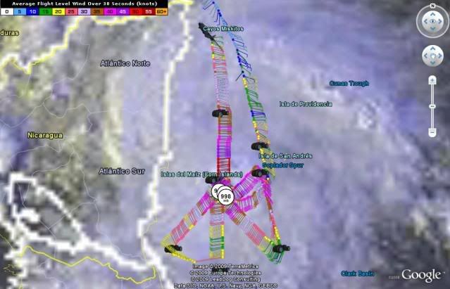
You can't assume a motion based on 2 recon fixes that may not be in the "center" of the center. Otherwise, that 3rd fix puts it moving WNW. It's not moving NNW or WNW.
Here's a graphic that I made last year during Gustav to demonstrate that fixes even slightly off-center can indicate an inaccurate heading if connected:

0 likes
-
jaxfladude
- Category 5

- Posts: 1249
- Joined: Wed Aug 24, 2005 9:36 pm
- Location: Jacksonville, Fla
Re: ATL : TROPICAL STORM IDA - Models
Prayers for all those in Ida's path; current and future if the models are correct.

0 likes
-
gatorcane

- S2K Supporter
- Posts: 23708
- Age: 48
- Joined: Sun Mar 13, 2005 3:54 pm
- Location: Boca Raton, FL
well now that is is rapidly deepening, let's see if it goes more poleward as some of the models had suggested (ECMWF/UKMET/GFDL)
Might feel the weakness to the NW more as it deepens.
It appears the EPAC area lost this battle.
Might feel the weakness to the NW more as it deepens.
It appears the EPAC area lost this battle.
Last edited by gatorcane on Wed Nov 04, 2009 5:54 pm, edited 2 times in total.
0 likes

-
gatorcane
- S2K Supporter
- Posts: 23708
- Age: 48
- Joined: Sun Mar 13, 2005 3:54 pm
- Location: Boca Raton, FL
I don't believe that it will stop and start moving back SE in the long-run, a very ridiculous and unlikely scenario in my opinion.
More likely scenario would be a slow North or NNW movement in the NW Carib then an accelerated bend to the NE or ENE out ahead of a trough. I think the long-range models are struggling some with the synoptics over the CONUS in the long-range and will eventually converge on that scenario. Keep in mind only yesterday the ECMWF thought Ida would get buried in Belize and bend west.
In November, the ridge and trough setups can change more quickly than in August for example as mid-lattitude systems traverse the CONUS.
0 likes
-
Derek Ortt
Who is online
Users browsing this forum: No registered users and 76 guests