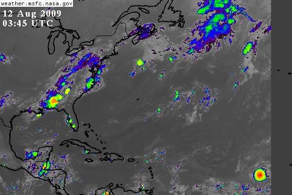
ATL: TROPICAL DEPRESSION ANA (02L)

Moderator: S2k Moderators

Message
Author
Aric Dunn
Category 5
Category 5
Posts: 21238
Age: 42
Joined: Sun Sep 19, 2004 9:58 pm
Location: Ready for the Chase.
Contact:

Re: ATL : TROPICAL DEPRESSION TWO

#561 Postby Aric Dunn » Tue Aug 11, 2009 11:22 pm

HURAKAN wrote:
cycloneye wrote:
Macrocane wrote:I think that if the trend continues a special advisory will be issued cause it looks very good, visible images would be so helpful at this time but we have to wait.


Its posible,if trend continues that may occur.


If it was close to land, then it's possible. But it's so far, that I think everyone can wait 4 hours and 46 minutes!

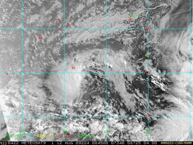
yeah no need to rush it, although with convection that deep, it is almost a certainty that its a Tropical storm. when the next set of microwave images come in i can imagine that we will be looking at a much different system than earlier. by all accounts this is Ana at the moment and a upgrade at 5am is most likely going to happen. The convection is going to flair down again here shortly as is typical of organizing systems, then it will fire again, its just the way convection wraps around. I have never seen a ball of convection like this maintain during the organization phase. Right now the mid to upper level circulation is very weak and until it is stacked in all layers we would never see a hurricane. so expect the convection to decrease by morning again.
0 likes   

Derek Ortt

Re:

#562 Postby Derek Ortt » Tue Aug 11, 2009 11:24 pm

rrm wrote:derek any possibility this gets in the gulf


too soon to say
0 likes   

Aric Dunn
Category 5
Category 5
Posts: 21238
Age: 42
Joined: Sun Sep 19, 2004 9:58 pm
Location: Ready for the Chase.
Contact:

#563 Postby Aric Dunn » Tue Aug 11, 2009 11:26 pm

actually another thing to note... I would not be surprised to see this start tracking wsw for the next 12 hours or more as this large mas of convection rotates around the center to the west then SW then south as it starts to collapse later. so a motion of 260-265 maybe possible for a short time.
0 likes   

Derek Ortt

#564 Postby Derek Ortt » Tue Aug 11, 2009 11:27 pm

be very patient calling for this to be upgraded

there have been very impressive burts in the past for systems with fragile LLCs. However, once the convection dies away (and it can be quickly), it creates a lot of divergence at the surface, causing the cyclone to degenerate into a wave

Not at all saying this will occur this time, but it is something to monitor
0 likes   

User avatar
drezee
S2K Supporter
S2K Supporter
Posts: 3664
Joined: Mon Jun 09, 2003 12:49 pm
Location: FL

Re: ATL : TROPICAL DEPRESSION TWO

#565 Postby drezee » Tue Aug 11, 2009 11:30 pm

drezee wrote:highres visible seems to indicate the LLC was to the SE of the MLC until about 1845 when it looked to pop NW. Looks to be be finally vertically stacked IMO. If that was a main hinderence(there are others), then this should pop over the next 12 hours.


10 hours later...we have a winner...
0 likes   

MWatkins
S2K Supporter
S2K Supporter
Posts: 2574
Joined: Sat Oct 12, 2002 7:51 pm
Location: SE Florida
Contact:

#566 Postby MWatkins » Tue Aug 11, 2009 11:38 pm

Quick note through 72 hours on the NOGAPS run, looks like a pretty zonal pattern to me all across the tropical atlantic with a bit of a weakness trying to develop in the middle of the ridge to the north. However, the vortex travels WSW for a couple of days before nudging back WNW in the last couple of frames. I don't know if this is going to be enough to turn TD2 or just slow it down for a little while.

MW
0 likes   

User avatar
Macrocane
Category 5
Category 5
Posts: 4218
Age: 36
Joined: Sun May 24, 2009 5:35 pm
Location: El Salvador

Re:

#567 Postby Macrocane » Tue Aug 11, 2009 11:39 pm

Derek Ortt wrote:be very patient calling for this to be upgraded

there have been very impressive burts in the past for systems with fragile LLCs. However, once the convection dies away (and it can be quickly), it creates a lot of divergence at the surface, causing the cyclone to degenerate into a wave

Not at all saying this will occur this time, but it is something to monitor


Yeah, look at Maka in the CPAC, it died quickly and it looked promising earlier.
0 likes   

User avatar
HURAKAN
Professional-Met
Professional-Met
Posts: 46086
Age: 38
Joined: Thu May 20, 2004 4:34 pm
Location: Key West, FL
Contact:

#568 Postby HURAKAN » Tue Aug 11, 2009 11:51 pm

Image

The vast Atlantic
0 likes   

User avatar
HURAKAN
Professional-Met
Professional-Met
Posts: 46086
Age: 38
Joined: Thu May 20, 2004 4:34 pm
Location: Key West, FL
Contact:

#569 Postby HURAKAN » Tue Aug 11, 2009 11:53 pm

Image

A close up on TD 2.
0 likes   

jinftl
Category 5
Category 5
Posts: 4312
Joined: Tue Aug 31, 2004 4:47 pm
Location: fort lauderdale, fl

Re: ATL : TROPICAL DEPRESSION TWO

#570 Postby jinftl » Wed Aug 12, 2009 1:34 am

With a few noteable exceptions, 'fish' would be the most likely outcome for td2/ana...based on what has happened to tds forming in that same general area during the month of august.....history says the odds are overwhelmingly in favor of this not be a Gulf storm and almost just as unlikely an East Coast storm....but there have been some very close misses for u.s. east coast tracks (in addition to the ones that actually did make landfall).

Image
0 likes   

clfenwi
Category 5
Category 5
Posts: 3331
Joined: Thu Jun 09, 2005 12:54 pm

Re: ATL : TROPICAL DEPRESSION TWO

#571 Postby clfenwi » Wed Aug 12, 2009 1:34 am

12/0545 UTC 13.9N 32.1W T2.0/2.0 02L -- Atlantic

SAB weighs in below TS strength (and an even further south position).

It's going to come down to what TAFB opines!
0 likes   

mikef55
Tropical Low
Tropical Low
Posts: 17
Joined: Wed Jul 16, 2008 10:46 am

#572 Postby mikef55 » Wed Aug 12, 2009 1:38 am

Yes definetly further south kinda suprised on numbers being below TS strengh though
0 likes   

jinftl
Category 5
Category 5
Posts: 4312
Joined: Tue Aug 31, 2004 4:47 pm
Location: fort lauderdale, fl

Re: ATL: TROPICAL DEPRESSION TWO (Models)

#573 Postby jinftl » Wed Aug 12, 2009 1:40 am

The one model that shows the sharpest recurve out to sea already is suggesting a wnw motion should take place....all the others suggest a possible wsw motion in the short-term.

Interesting to look at the current model runs vs the prior plots below. GFDL and UKMET have shifted further south and west.

Image

Hadn't checked model runs all day....bit surprised when this i saw this latest model composite....what happened to the hard right turn...for now....consistency and agreement will be the key this far out...

Image
Last edited by jinftl on Wed Aug 12, 2009 6:00 am, edited 2 times in total.
0 likes   

jinftl
Category 5
Category 5
Posts: 4312
Joined: Tue Aug 31, 2004 4:47 pm
Location: fort lauderdale, fl

Re: ATL : TROPICAL DEPRESSION TWO

#574 Postby jinftl » Wed Aug 12, 2009 1:48 am

Only light shear at most as long as td2/ana stays below 20N...and indications for the short-moderate-term are she will. What a difference a few weeks makes in terms of overall shear across the basin. Even if the predominant conditions are less favorable in an el nino season, clearly that does not mean at every moment in every location shear is a constant force hindering storms.

Image
0 likes   

clfenwi
Category 5
Category 5
Posts: 3331
Joined: Thu Jun 09, 2005 12:54 pm

Re: ATL : TROPICAL DEPRESSION TWO

#575 Postby clfenwi » Wed Aug 12, 2009 1:51 am

AL, 02, 2009081206, , BEST, 0, 146N, 319W, 30, 1006, TD, 34, NEQ, 0, 0, 0, 0, 1012, 150, 30, 0, 0, L, 0, , 0, 0, TWO, M,

Best track position favors, but is not identical to TAFB's position estimate. A cool 55 nautical miles separates TAFB's and SAB's estimates.
0 likes   

clfenwi
Category 5
Category 5
Posts: 3331
Joined: Thu Jun 09, 2005 12:54 pm

Re: ATL: TROPICAL DEPRESSION TWO (Models)

#576 Postby clfenwi » Wed Aug 12, 2009 2:02 am

Code: Select all

*   ATLANTIC SHIPS INTENSITY FORECAST       *
                    *      GOES DATA MISSING, PROXY USED        *
                    *      OHC  DATA AVAILABLE                  *
                    *         TWO  AL022009  08/12/09  06 UTC   *

TIME (HR)          0     6    12    18    24    36    48    60    72    84    96   108   120
V (KT) NO LAND    30    33    36    40    44    49    54    57    62    61    56    53    47
V (KT) LAND       30    33    36    40    44    49    54    57    62    61    56    53    47
V (KT) LGE mod    30    33    35    37    39    43    47    50    54    58    59    57    53

SHEAR (KT)         5    10    15    17    17    15    14     7    10    13    26    26    35
SHEAR DIR        150   119   120   109   121   101   132   158   212   211   246   252   252
SST (C)         27.3  27.2  27.1  27.0  26.9  26.8  26.6  26.6  26.7  27.1  27.6  28.0  28.3
POT. INT. (KT)   128   127   126   124   123   123   120   121   122   128   134   138   142
ADJ. POT. INT.   123   122   121   119   119   119   116   116   118   126   130   130   131
200 MB T (C)   -53.3 -53.1 -52.4 -52.6 -53.0 -52.2 -52.6 -52.6 -52.8 -52.6 -52.6 -53.0 -52.8
TH_E DEV (C)       7     7     7     6     7     7     7     7     8     9     9    10    10
700-500 MB RH     63    62    62    60    62    60    61    62    55    50    48    48    43
GFS VTEX (KT)     12    11    13    14    14    12    12    10    11    11     9     9     7
850 MB ENV VOR    73    66    81    92    89    67    71    54    48    31    -4   -29   -69
200 MB DIV        17     1    27    67    71    76    44    41    28   -21     0    -7    -8
LAND (KM)       1547  1666  1784  1897  1989  1820  1660  1557  1491  1470  1328  1139  1000
LAT (DEG N)     14.6  14.6  14.6  14.6  14.6  14.8  15.2  15.8  16.8  18.0  19.5  21.0  22.5
LONG(DEG W)     31.9  33.0  34.1  35.2  36.2  38.7  41.2  43.5  46.0  49.0  52.5  55.2  57.2
STM SPEED (KT)    10    11    11    10    11    12    12    12    14    17    16    13    12
HEAT CONTENT      10     9     8     7     7     7     8    11    15    28    45    45    44
0 likes   

User avatar
Thunder44
Category 5
Category 5
Posts: 5922
Age: 44
Joined: Mon Jun 09, 2003 7:53 pm
Location: New York City

Re: ATL : TROPICAL DEPRESSION TWO (Advisories)

#577 Postby Thunder44 » Wed Aug 12, 2009 4:04 am

000
WTNT32 KNHC 120832
TCPAT2
BULLETIN
TROPICAL DEPRESSION TWO ADVISORY NUMBER 5
NWS TPC/NATIONAL HURRICANE CENTER MIAMI FL AL022009
500 AM AST WED AUG 12 2009

...DEPRESSION HAS NOT STRENGTHENED YET...

AT 500 AM AST...0900 UTC...THE CENTER OF TROPICAL DEPRESSION TWO WAS
LOCATED NEAR LATITUDE 14.6 NORTH...LONGITUDE 32.4 WEST OR ABOUT 535
MILES...860 KM...WEST OF THE SOUTHERNMOST CAPE VERDE ISLANDS.

THE DEPRESSION IS MOVING TOWARD THE WEST NEAR 12 MPH...19 KM/HR...
AND THIS GENERAL MOTION IS EXPECTED FOR THE NEXT DAY OR TWO WITH
SOME INCREASE IN FORWARD SPEED.

MAXIMUM SUSTAINED WINDS ARE NEAR 35 MPH...55 KM/HR...WITH HIGHER
GUSTS. THE DEPRESSION COULD BECOME A TROPICAL STORM DURING THE NEXT
COUPLE OF DAYS.

THE ESTIMATED MINIMUM CENTRAL PRESSURE IS 1006 MB...29.71 INCHES.

...SUMMARY OF 500 AM AST INFORMATION...
LOCATION...14.6N 32.4W
MAXIMUM SUSTAINED WINDS...35 MPH
PRESENT MOVEMENT...WEST OR 270 DEGREES AT 12 MPH
MINIMUM CENTRAL PRESSURE...1006 MB

THE NEXT ADVISORY WILL BE ISSUED BY THE NATIONAL HURRICANE CENTER AT
1100 AM AST.

$$
FORECASTER BLAKE


000
WTNT42 KNHC 120835
TCDAT2
TROPICAL DEPRESSION TWO DISCUSSION NUMBER 5
NWS TPC/NATIONAL HURRICANE CENTER MIAMI FL AL022009
500 AM AST WED AUG 12 2009

SATELLITE IMAGES INDICATE THAT A PERSISTENT CLUSTER OF THUNDERSTORMS
REMAINS IN THE WESTERN SEMICIRCLE OF THE DEPRESSION...ALTHOUGH
RECENTLY THIS CLUSTER HAS TAKEN ON A SOMEWHAT ELONGATED APPEARANCE.
MICROWAVE AND SHORTWAVE INFRARED DATA SUGGEST THE CENTER REMAINS ON
THE EASTERN SIDE OF THE CONVECTION AND NOT WELL-EMBEDDED WITHIN THE
MAIN CONVECTIVE CLUSTER. DVORAK ESTIMATES SUGGEST THE MAXIMUM
WINDS ARE NEAR 30 KT...AND THE INITIAL INTENSITY WILL BE HELD AT
THAT VALUE.

THERE IS CONSIDERABLE UNCERTAINTY WITH THE INITIAL POSITION...AND
THE BEST GUESS OF INITIAL MOTION IS 270/10. GLOBAL MODELS SUGGEST A
GENERAL WESTERLY COURSE IS LIKELY FOR THE NEXT COUPLE OF DAYS AS
RIDGING BUILDS TO THE NORTH OF THE DEPRESSION. THEREAFTER...A
WEAKNESS IN THE SUBTROPICAL HIGH OVER THE CENTRAL ATLANTIC OCEAN
COULD CAUSE THE TROPICAL CYCLONE TO GAIN SOME LATITUDE. ALTHOUGH
THE HWRF/BAMD MODELS SHOW A SHARP NORTHWESTWARD MOTION IN THE
LATTER HALF OF THE FORECAST PERIOD...MOST OF THE MODEL GUIDANCE
SUGGEST ONLY A GRADUAL BEND TO A WEST-NORTHWEST TRACK WITH AN
INCREASE IN FORWARD SPEED DUE TO A HIGH BUILDING OVER THE WESTERN
ATLANTIC. THE OFFICIAL FORECAST IS ADJUSTED SLIGHTLY SOUTHWARD IN
THE FIRST FEW DAYS...BUT ENDS UP VERY CLOSE TO THE PREVIOUS
FORECAST BY THE END OF THE PERIOD.

LIGHT TO MODERATE SOUTHEASTERLY SHEAR IS EXPECTED FOR THE NEXT
SEVERAL DAYS WHILE THE SYSTEM TRAVERSES MARGINALLY WARM WATERS. IN
GENERAL...THIS ENVIRONMENT WOULD SUPPORT SOME STRENGTHENING...
THOUGH THE PRESENCE OF SOME DRIER/STABLE AIR JUST TO THE NORTH OF
THE DEPRESSION MAY PLAY AN INHIBITING ROLE. THE STATISTICAL MODELS
SUGGEST THAT THE DEPRESSION COULD BE CLOSE TO HURRICANE STRENGTH IN
A FEW DAYS...WHILE THE DYNAMICAL GUIDANCE SHOWS ONLY A LOW-END
TROPICAL STORM. THE NHC INTENSITY FORECAST WILL BASICALLY SPLIT
THE DIFFERENCE BETWEEN THOSE OUTCOMES AND REMAINS CLOSE TO THE
PREVIOUS ONE. IN THE LONGER-TERM...MOST OF THE GLOBAL MODELS
INCREASE THE VERTICAL SHEAR...WHICH SHOULD CAUSE A WEAKENING TREND
WHILE THE SYSTEM IS OVER THE CENTRAL ATLANTIC.

FORECAST POSITIONS AND MAX WINDS

INITIAL 12/0900Z 14.6N 32.4W 30 KT
12HR VT 12/1800Z 14.6N 34.0W 35 KT
24HR VT 13/0600Z 14.6N 36.4W 35 KT
36HR VT 13/1800Z 14.6N 38.9W 40 KT
48HR VT 14/0600Z 15.0N 41.4W 45 KT
72HR VT 15/0600Z 16.5N 46.5W 50 KT
96HR VT 16/0600Z 19.0N 52.5W 45 KT
120HR VT 17/0600Z 22.5N 58.5W 40 KT

$$
FORECASTER BLAKE
0 likes   

User avatar
HURAKAN
Professional-Met
Professional-Met
Posts: 46086
Age: 38
Joined: Thu May 20, 2004 4:34 pm
Location: Key West, FL
Contact:

#578 Postby HURAKAN » Wed Aug 12, 2009 4:14 am

Image

Image

Visible imagery is here
0 likes   

User avatar
Thunder44
Category 5
Category 5
Posts: 5922
Age: 44
Joined: Mon Jun 09, 2003 7:53 pm
Location: New York City

Re: ATL : TROPICAL DEPRESSION TWO

#579 Postby Thunder44 » Wed Aug 12, 2009 4:20 am

HURAKAN, is that the center exposed near 14N and 32.5W? Looks to me like it is. It's not far from NHC's 5am position.
Last edited by Thunder44 on Wed Aug 12, 2009 4:25 am, edited 1 time in total.
0 likes   

User avatar
HURAKAN
Professional-Met
Professional-Met
Posts: 46086
Age: 38
Joined: Thu May 20, 2004 4:34 pm
Location: Key West, FL
Contact:

Re: ATL : TROPICAL DEPRESSION TWO

#580 Postby HURAKAN » Wed Aug 12, 2009 4:25 am

Thunder44 wrote:HURAKAN, is that the center exposed near 14N and 32.5W?


Looks like it.
0 likes   


Return to “2009”

Who is online

Users browsing this forum: No registered users and 5 guests