WPAC : TROPICAL DEPRESSION MIRINAE (23W)

Moderator: S2k Moderators

Message
Author
cebuboy
Tropical Depression
Tropical Depression
Posts: 94
Joined: Wed Sep 30, 2009 5:29 am
Location: Cebu, Philippines

Re: WPAC : TYPHOON MIRINAE (23W)

#781 Postby cebuboy » Wed Oct 28, 2009 10:34 am

Infdidoll wrote:The inflow/outflow channels for this typhoon are absolutely amazing, aren't they?

Just read the article about the volcano, too. That is nuts! Did someone put a curse on the Philippines? Seriously.

Metenthusiast - Any luck getting your appt rescheduled? We'll be thinking about you...


Mindanao belongs to most of the muslim Filipinos and poor Visayans. Government which is mostly govern by people of Luzon ignored the needs and support for Muslims and poor Visayans. As a result, there is no peace in Mindanao (always in conflict) and lot of poor Visayans lose hope due to corruption. While in Luzon, lot of lavish and entertainment government officials are enjoying their time in the entertainment sector.Maybe Mindawanons put a curse on our northern people for failing to exert help and support for them throughout centuries, just my wild opinion as a Filipino.

You maybe surprised, Mindanao is never hit by a deadly typhoon or a deadly calamity. It could also support the curse theory :lol:
0 likes   

User avatar
HURAKAN
Professional-Met
Professional-Met
Posts: 46086
Age: 38
Joined: Thu May 20, 2004 4:34 pm
Location: Key West, FL
Contact:

#782 Postby HURAKAN » Wed Oct 28, 2009 10:34 am

Multiagency:

Image
0 likes   

User avatar
drdavisjr
Category 1
Category 1
Posts: 428
Age: 57
Joined: Mon Oct 12, 2009 7:07 am
Location: Marilao, Bulacan, Philippines
Contact:

#783 Postby drdavisjr » Wed Oct 28, 2009 10:53 am

You guys have a good afternoon, I'm off to bed also.
0 likes   

ozonepete
Professional-Met
Professional-Met
Posts: 4743
Joined: Mon Sep 07, 2009 3:23 pm
Location: From Ozone Park, NYC / Now in Brooklyn, NY

Re:

#784 Postby ozonepete » Wed Oct 28, 2009 10:55 am

drdavisjr wrote:Image

I found an interesting ensemble. Maybe one of the veteran members can help us disect this??


That is an ensemble run from the GFS model. An ensemble is a collection of runs of different models or, in this case a collection of runs of the GFS model with many ifferent "perturbations" or small changes in the initial (and/or future conditions) in the area of the cyclone. You'd generally loook for the track nearest the center of the cluster for the average, and you look for "outliers" (ones that are far away from most of the others.) The more outliers there are, the less you can trust the output.
0 likes   

ozonepete
Professional-Met
Professional-Met
Posts: 4743
Joined: Mon Sep 07, 2009 3:23 pm
Location: From Ozone Park, NYC / Now in Brooklyn, NY

Re:

#785 Postby ozonepete » Wed Oct 28, 2009 10:57 am

drdavisjr wrote:You guys have a good afternoon, I'm off to bed also.


Good night to all of you. We'll keep watching over here. :)
0 likes   

User avatar
cycloneye
Admin
Admin
Posts: 145331
Age: 68
Joined: Thu Oct 10, 2002 10:54 am
Location: San Juan, Puerto Rico

Re: WPAC : TYPHOON MIRINAE (23W) PAGASA=TYPHOON SANTI

#786 Postby cycloneye » Wed Oct 28, 2009 11:01 am

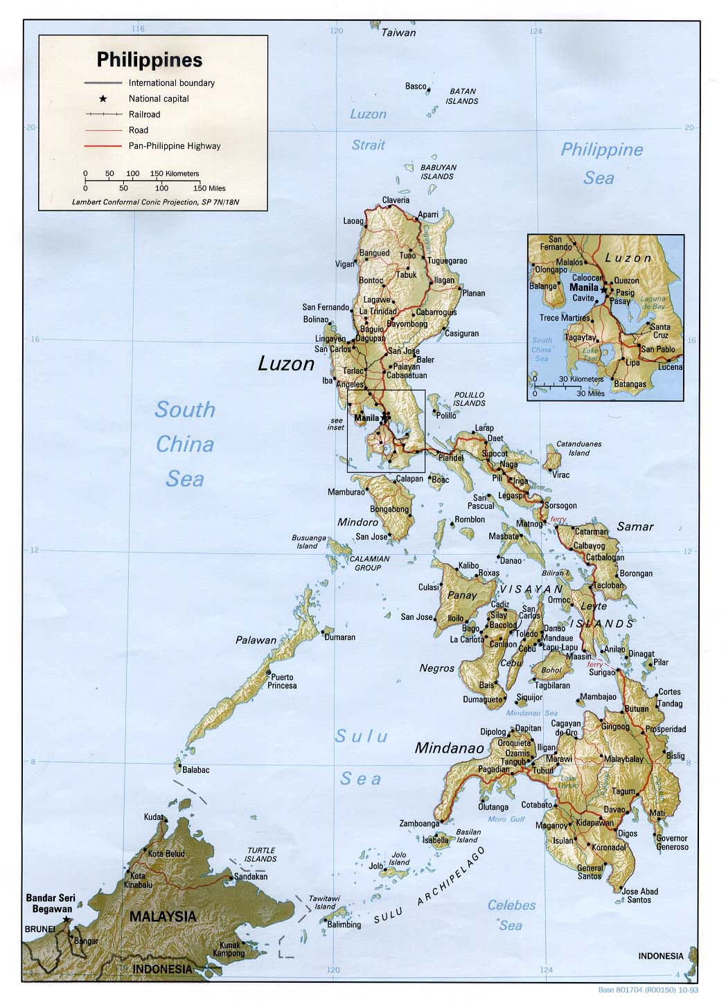
For those members who dont know where are the cities of the Philiphines,here is a good map.

Jim,Tuguegarao is very far north from Manila but what ozonepete said is a good recomendation as you can go south from there.But the problem may be transportation as it was said earlier.Lets see what you can do to seek transportation from Manila northward and then to the south.

Image
0 likes   
Visit the Caribbean-Central America Weather Thread where you can find at first post web cams,radars
and observations from Caribbean basin members Click Here

User avatar
cycloneye
Admin
Admin
Posts: 145331
Age: 68
Joined: Thu Oct 10, 2002 10:54 am
Location: San Juan, Puerto Rico

Re: WPAC : TYPHOON MIRINAE (23W) PAGASA=TYPHOON SANTI

#787 Postby cycloneye » Wed Oct 28, 2009 11:10 am

Prognostic Reasoning by JTWC at 1500z Warning

Is there good news here is that the intensity by landfall wont be as a Supertyphoon.But neverless,this will do a great deal of wind damage apart from the floods and mudslides.

PN32 PGTW 281500
MSGID/GENADMIN/NAVMARFCSTCEN PEARL HARBOR HI/JTWC//
SUBJ/PROGNOSTIC REASONING FOR TYPHOON 23W (MIRINAE) WARNING NR 11//
RMKS/
1. FOR METEOROLOGISTS.
2. 12 HOUR SUMMARY AND ANALYSIS.
A. TYPHOON (TY) 23W (MIRINAE) HAS CONTINUED TO TRACK DUE WEST
OVER THE PAST 12 HOURS AND HAS MAINTAINED AN INTENSITY OF 85 KNOTS.
DVORAK ESTIMATES FROM PGTW, KNES AND RJTD APPROXIMATE AN 80 TO 90
KNOT SYSTEM. THE POLEWARD OUTFLOW CHANNEL THAT HAD INITIATED RAPID
INTENSIFICATION 24 HOURS AGO HAS BEGUN TO WEAKEN DUE TO INCREASED
SEPARATION DISTANCE BETWEEN THE LONGWAVE TROUGH TO THE NORTH AND THE
SYSTEM. THERE HAS ALSO BEEN A SLIGHT INCREASE IN VERTICAL WIND SHEAR
AS THE SYSTEM MOVES FARTHER FROM THE UPPER LEVEL RIDGE CENTER NEAR
17N 145E.
3. FORECAST REASONING
A. THE FORECAST REASONING HAS NOT CHANGED SINCE THE PREVIOUS
PROGNOSTIC REASONING BULLETIN.
B. THE TYPHOON WILL CONTINUE TO TRACK WESTWARD ALONG THE
SOUTHERN PERIPHERY OF THE SUBTROPICAL RIDGE TO THE NORTH, TOWARDS
LUZON, WHILE MAKING MODEST INTENSITY GAINS. RADIAL OUTFLOW
ASSOCIATED WITH THE MESOSCALE ANTICYCLONE OVER THE SYSTEM, IN
ADDITION TO SEA SURFACE TEMPERATURES NEAR 30 DEGREES CELSIUS, WILL
HELP OFFSET INCREASED VERTICAL WIND SHEAR. HOWEVER, INTENSIFICATION
IS EXPECTED TO SLOW MAINLY DUE TO THE LACK OF A STRONG (POLEWARD)
OUTFLOW MECHANISM. A PEAK INTENSITY NEAR 105 KNOTS IS STILL EXPECTED
PRIOR TO MIRINAE MAKING LANDFALL WITH LUZON BETWEEN TAU 48 AND 72.
MODEL GUIDANCE CONTINUES TO BE IN EXCEPTIONAL AGREEMENT WITH THIS
FORECAST TRACK.
C. JUST BEFORE TAU 72 THE SYSTEM WILL EXIT INTO THE SOUTH CHINA
SEA FROM LUZON AS A MUCH-WEAKENED TYPHOON. A COOLER POOL OF SEA
SURFACE TEMPERATURES IN THE CENTRAL SOUTH CHINA SEA WILL PROMOTE A
SLOW WEAKENING. AN EARLY SEASON COLD SURGE WILL ALSO AID IN
WEAKENING THE SYSTEM CLOSER TO TAU 120.//
0 likes   
Visit the Caribbean-Central America Weather Thread where you can find at first post web cams,radars
and observations from Caribbean basin members Click Here

ozonepete
Professional-Met
Professional-Met
Posts: 4743
Joined: Mon Sep 07, 2009 3:23 pm
Location: From Ozone Park, NYC / Now in Brooklyn, NY

Re: WPAC : TYPHOON MIRINAE (23W) PAGASA=TYPHOON SANTI

#788 Postby ozonepete » Wed Oct 28, 2009 11:17 am

cycloneye wrote:Jim,Tuguegarao is very far north from Manila but what ozonepete said is a good recomendation as you can go south from there.But the problem may be transportation as it was said earlier.Lets see what you can do to seek transportation from Manila northward and then to the south.


Yes that's an important point, cycloneye. They said it's 8-10 hours from Manila to Tugeugarao by car or bus. An alternative plan would be to go to Casaguran, which is pretty much the JTWC landfall point. Casaguran should be about only 5 or 6 hours from Manila. Baler, the JMA landfall point, is only about 50 miles south of Casaguran. So it would be much easier to move north or south as needed. As a matter of fact, I think that's probably a better solution considering the heavy holiday traffic and advance rains that may be there by Friday morning.


EDITED to fine-tune the geography and current agency forecast target cities.
0 likes   

ozonepete
Professional-Met
Professional-Met
Posts: 4743
Joined: Mon Sep 07, 2009 3:23 pm
Location: From Ozone Park, NYC / Now in Brooklyn, NY

Re: WPAC : TYPHOON MIRINAE (23W) PAGASA=TYPHOON SANTI

#789 Postby ozonepete » Wed Oct 28, 2009 12:25 pm

Right now, BTW, I still think it will be around Baler. In addition, I see some possibilities of this shifting to a more west-southwest track. In that case I might change my landfall point even further south tomorrow.


The posts in this forum are NOT official forecast and should not be used as such. They are just the opinion of the poster and may or may not be backed by sound meteorological data. They are NOT endorsed by any professional institution or storm2k.org. For official information, please refer to the NHC and NWS products.
0 likes   

User avatar
HURAKAN
Professional-Met
Professional-Met
Posts: 46086
Age: 38
Joined: Thu May 20, 2004 4:34 pm
Location: Key West, FL
Contact:

#790 Postby HURAKAN » Wed Oct 28, 2009 12:32 pm

Image

Latest
0 likes   

Derek Ortt

#791 Postby Derek Ortt » Wed Oct 28, 2009 12:46 pm

JTs reasoning makes no sense

warm SST does not offset vertical shear. Can have SSTs of 90C, but if you have high shear, nothing is going to form
0 likes   

ozonepete
Professional-Met
Professional-Met
Posts: 4743
Joined: Mon Sep 07, 2009 3:23 pm
Location: From Ozone Park, NYC / Now in Brooklyn, NY

Re:

#792 Postby ozonepete » Wed Oct 28, 2009 12:52 pm

HURAKAN wrote:Latest


Pretty good symmetry and the eye's more apparent again. I see what JTWC is saying about the poleward outflow - it's not a very smooth channel so the venting is lacking. I'm also still wary of the dry air but it certainly doesn't seem to be getting entrained and there are signs now that the dry air is moistening up, so it may never be an issue. Finally, I see some signs in the cloud-tracked winds that the STR may be building down a little more north of the storm than forecast. If this trend continues, it very well may go further south. Just something to watch for.
0 likes   

ozonepete
Professional-Met
Professional-Met
Posts: 4743
Joined: Mon Sep 07, 2009 3:23 pm
Location: From Ozone Park, NYC / Now in Brooklyn, NY

Re:

#793 Postby ozonepete » Wed Oct 28, 2009 12:57 pm

Derek Ortt wrote:JTs reasoning makes no sense

warm SST does not offset vertical shear. Can have SSTs of 90C, but if you have high shear, nothing is going to form


I agree 100%. That's just wrong. If there's shear and/or dry air SSTs and OHC mean nothing.
0 likes   

ozonepete
Professional-Met
Professional-Met
Posts: 4743
Joined: Mon Sep 07, 2009 3:23 pm
Location: From Ozone Park, NYC / Now in Brooklyn, NY

Re: WPAC : TYPHOON MIRINAE (23W) PAGASA=TYPHOON SANTI

#794 Postby ozonepete » Wed Oct 28, 2009 1:03 pm

BTW, speaking of shear, the JTWC until recently has been saying shear would remain very low along the forecast path, and now they are talking about increased vertical shear, but the latest CIMSS charts I see show 20-30 knots of south or SSE shear ahead of this cyclone, especially after it crosses the 130 longitude. That's WAY different from what they were saying and could have a major weakening impact. I wonder when they'll start talking about it more. I now am suspect about how strong this can get or how strong it will be as it nears Luzon.

(sorry can't post images from here)
0 likes   

User avatar
cycloneye
Admin
Admin
Posts: 145331
Age: 68
Joined: Thu Oct 10, 2002 10:54 am
Location: San Juan, Puerto Rico

Re: WPAC : TYPHOON MIRINAE (23W) PAGASA=TYPHOON SANTI

#795 Postby cycloneye » Wed Oct 28, 2009 1:50 pm

18 UTC JMA Warning

TY 0921 (Mirinae)
Issued at 18:45 UTC, 28 October 2009
<Analyses at 28/18 UTC>
Scale -
Intensity Strong
Center position N16°10'(16.2°)
E134°00'(134.0°)
Direction and speed of movement W 25km/h(14kt)
Central pressure 955hPa
Maximum wind speed near the center 40m/s(80kt)
Maximum wind gust speed 60m/s(115kt)
Area of 50kt winds or more Wide 130km(70NM)
Area of 30kt winds or more N410km(220NM)
S260km(140NM)

<Forecast for 29/18 UTC>
Intensity Strong
Center position of probability circle N16°00'(16.0°)
E129°00'(129.0°)
Direction and speed of movement W 20km/h(12kt)
Central pressure 945hPa
Maximum wind speed near the center 40m/s(80kt)
Maximum wind gust speed 60m/s(115kt)
Radius of probability circle 140km(75NM)
Storm warning area Wide 300km(160NM)

<Forecast for 30/18 UTC>
Intensity Very Strong
Center position of probability circle N15°40'(15.7°)
E124°05'(124.1°)
Direction and speed of movement W 20km/h(12kt)
Central pressure 940hPa
Maximum wind speed near the center 45m/s(85kt)
Maximum wind gust speed 60m/s(120kt)
Radius of probability circle 260km(140NM)
Storm warning area Wide 430km(230NM)

<Forecast for 31/18 UTC>
Intensity Strong
Center position of probability circle N15°55'(15.9°)
E118°50'(118.8°)
Direction and speed of movement W 25km/h(13kt)
Central pressure 950hPa
Maximum wind speed near the center 40m/s(80kt)
Maximum wind gust speed 60m/s(115kt)
Radius of probability circle 390km(210NM)
Storm warning area Wide 540km(290NM)

Image
0 likes   
Visit the Caribbean-Central America Weather Thread where you can find at first post web cams,radars
and observations from Caribbean basin members Click Here

ozonepete
Professional-Met
Professional-Met
Posts: 4743
Joined: Mon Sep 07, 2009 3:23 pm
Location: From Ozone Park, NYC / Now in Brooklyn, NY

Re: WPAC : TYPHOON MIRINAE (23W) PAGASA=TYPHOON SANTI

#796 Postby ozonepete » Wed Oct 28, 2009 2:46 pm

1830 IR satellite shows the circulation seems to be enlarging now. I don't see any signs of dry air coming in, and it has a nice CDO with the eye pretty well centered underneath it, even though it's still not visible on this or other conventional satellite images. Also, there are no signs of shear yet. Finally, despite what JTWC says, the outflow looks pretty decent to me on the water vapor channel, both poleward and equatorward. I would think it will have a pretty decent round of intensification now if the shear and dry air remain low for the next 12 hours.
0 likes   

User avatar
ManilaTC
WesternPacificWeather.com
Posts: 593
Age: 47
Joined: Mon Oct 26, 2009 5:13 am
Location: Mandaluyong City, Philippines
Contact:

#797 Postby ManilaTC » Wed Oct 28, 2009 2:55 pm

Hi all, its almost 4 am in the morning here in manila.

JMA has lowered its track... will JTWC follow?

I am still expecting a wsw track later today...

The posts in this forum are NOT official forecast and should not be used as such. They are just the opinion of the poster and may or may not be backed by sound meteorological data. They are NOT endorsed by any professional institution or storm2k.org. For official information, please refer to the NHC and NWS products.
0 likes   
The above post is NOT official and should not be used as such. It is my opinion and may or may not be backed by sound meteorological data. It is not endorsed by any professional institution or storm2k.org. Please refer to your official national weather agency.

WEB http://goo.gl/JDiKXB | FB https://goo.gl/N5sIle | @ManilaTC

User avatar
ManilaTC
WesternPacificWeather.com
Posts: 593
Age: 47
Joined: Mon Oct 26, 2009 5:13 am
Location: Mandaluyong City, Philippines
Contact:

#798 Postby ManilaTC » Wed Oct 28, 2009 3:10 pm

Now checking on the other agencies...

** WTPQ20 BABJ 281800 ***
SUBJECTIVE FORECAST
TY MIRINAE 0921 (0921) INITIAL TIME 281800 UTC
00HR 16.3N 134.0E 955HPA 40M/S
30KTS 300KM
50KTS 100KM
P12HR W 25KM/H
P+24HR 16.1N 128.4E 950HPA 43M/S
P+48HR 15.8N 123.4E 945HPA 45M/S
P+72HR 16.0N 118.6E 960HPA 38M/S
P+96HR 15.4N 113.8E 965HPA 35M/S=


** WTKO20 RKSL 281800 ***
KMA TROPICAL CYCLONE ADVISORY NO. 7
NAME TY 0921 MIRINAE
ANALYSIS
POSITION 281800UTC 16.2N 134.0E
MOVEMENT W 15KT
PRES/VMAX 955HPA 80KT
FORECAST
24HR
POSITION 291800UTC 16.1N 128.9E WITHIN 80NM
PRES/VMAX 950HPA 84KT
48HR
POSITION 301800UTC 15.8N 124.0E WITHIN 135NM
PRES/VMAX 945HPA 87KT
72HR
POSITION 311800UTC 16.1N 118.7E WITHIN 215NM
PRES/VMAX 955HPA 80KT
KOREA METEOROLOGICAL ADMINISTRATION.

CWB - Taiwan
Typhoon MIRINAE (0921)
Typhoon Status
1800UTC 28 October 2009
Center Location 16.2N 134.0E
Movement WEST 27km/hr
Minimum Pressure 955hPa
Maximum Wind Speed 40m/s
Gust 50m/s
Radius of 15m/s 180km
Radius of 25m/s 50km
Typhoon Forecast
12 hours valid at:
0600UTC 29 October 2009
Center Position 16.1N 131.2E
Vector to 12 HR Position
WEST 25km/hr
Radius of 70% probability circle 80km
24 hours valid at:
1800UTC 29 October 2009
Center Position 15.7N 128.4E
Vector to 24 HR Position
WEST 25km/hr
Radius of 70% probability circle 130km
36 hours valid at:
0600UTC 30 October 2009
Center Position 15.4N 125.8E
Vector to 36 HR Position
WEST 23km/hr
Radius of 70% probability circle 175km
48 hours valid at:
1800UTC 30 October 2009
Center Position 15.3N 123.3E
Vector to 48 HR Position
WEST 22km/hr
Radius of 70% probability circle 220km
72 hours valid at:
1800UTC 31 October 2009
Center Position 15.3N 118.8E
Vector to 72 HR Position
WEST 20km/hr
Radius of 70% probability circle 360km
96 hours valid at:
1800UTC 01 November 2009
Center Position 15.2N 114.3E
Vector to 96 HR Position
WEST 20km/hr
Radius of 70% probability circle 510km
120 hours valid at:
1800UTC 02 November 2009
Center Position 14.7N 109.8E
Vector to 120 HR Position
WEST 20km/hr
Radius of 70% probability circle 760km

They have all brought their tracks down...
0 likes   
The above post is NOT official and should not be used as such. It is my opinion and may or may not be backed by sound meteorological data. It is not endorsed by any professional institution or storm2k.org. Please refer to your official national weather agency.

WEB http://goo.gl/JDiKXB | FB https://goo.gl/N5sIle | @ManilaTC

User avatar
HURAKAN
Professional-Met
Professional-Met
Posts: 46086
Age: 38
Joined: Thu May 20, 2004 4:34 pm
Location: Key West, FL
Contact:

#799 Postby HURAKAN » Wed Oct 28, 2009 3:23 pm

ZCZC 454
WTPQ21 RJTD 281800
RSMC TROPICAL CYCLONE ADVISORY
NAME TY 0921 MIRINAE (0921)
ANALYSIS
PSTN 281800UTC 16.2N 134.0E FAIR
MOVE W 14KT
PRES 955HPA
MXWD 080KT
GUST 115KT
50KT 70NM
30KT 220NM NORTH 140NM SOUTH
FORECAST
24HF 291800UTC 16.0N 129.0E 75NM 70%
MOVE W 12KT
PRES 945HPA
MXWD 080KT
GUST 115KT
48HF 301800UTC 15.7N 124.1E 140NM 70%
MOVE W 12KT
PRES 940HPA
MXWD 085KT
GUST 120KT
72HF 311800UTC 15.9N 118.8E 210NM 70%
MOVE W 13KT
PRES 950HPA
MXWD 080KT
GUST 115KT =
NNNN
0 likes   

User avatar
theavocado
Professional-Met
Professional-Met
Posts: 162
Age: 49
Joined: Sun Mar 22, 2009 8:54 pm
Location: NOLA

Re:

#800 Postby theavocado » Wed Oct 28, 2009 3:49 pm

Derek Ortt wrote:JTs reasoning makes no sense

warm SST does not offset vertical shear. Can have SSTs of 90C, but if you have high shear, nothing is going to form


RADIAL OUTFLOW ASSOCIATED WITH THE MESOSCALE ANTICYCLONE OVER THE SYSTEM, IN ADDITION TO SEA SURFACE TEMPERATURES NEAR 30 DEGREES CELSIUS, WILL HELP OFFSET INCREASED VERTICAL WIND SHEAR

I think you took it out of context. The mesoscale anti-cyclone would be set up over the system, and would continue to be there as long as the upward vertical motion associated with the rapid release of latent heat was present. It is the mesoscale anticyclone that offsets the vertical windshear in the region, and the high SSTs keep the latent heat release high enough to support the anti-cyclone. Once an anti-cyclone sets up over the system, vertical wind shear is almost nil.

Strong systems alter their own environment, and VWS below the values associated with the deformation zone and/or subtropical jet are generally not enough to overcome the cocoon the system has set up.

I will admit that the sentence is very poorly written, and the subordinate clause doesn't help. I think they were trying too hard to be creative on the writing without just being blunt.
Last edited by theavocado on Wed Oct 28, 2009 3:56 pm, edited 1 time in total.
0 likes   


Return to “2009”

Who is online

Users browsing this forum: No registered users and 9 guests