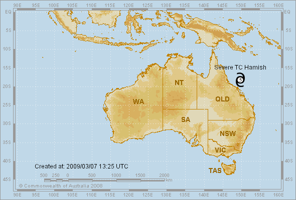
Coral Sea: HAMISH - Tropical Cyclone
Moderator: S2k Moderators

Re: Coral Sea: HAMISH - Severe Tropical Cyclone
18P HAMISH 090307 0600 17.9S 148.8E SHEM 115 937
0 likes
-
Craiga74

- Tropical Low

- Posts: 42
- Age: 51
- Joined: Thu Feb 21, 2008 8:59 am
- Location: Port Hedland, Australia
- Contact:
Re: Coral Sea: HAMISH - Severe Tropical Cyclone
IDQ20018
TROPICAL CYCLONE TECHNICAL BULLETIN: AUSTRALIA - EASTERN REGION
Issued by BRISBANE TROPICAL CYCLONE WARNING CENTRE
at: 0729 UTC 07/03/2009
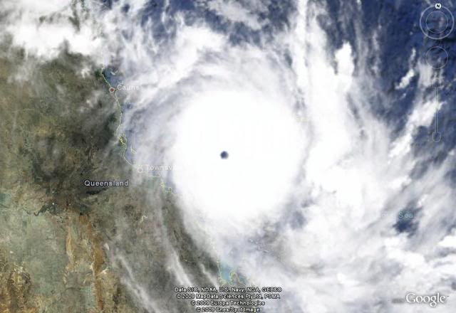
Name: Severe Tropical Cyclone Hamish
Identifier: 17U
Data At: 0600 UTC
Latitude: 17.9S
Longitude: 148.8E
Location Accuracy: within 10 nm [19 km]
Movement Towards: south southeast [148 deg]
Speed of Movement: 10 knots [19 km/h]
Maximum 10-Minute Wind: 100 knots [185 km/h]
Maximum 3-Second Wind Gust: 140 knots [260 km/h]
Central Pressure: 950 hPa
Radius of 34-knot winds NE quadrant: 110 nm [205 km]
Radius of 34-knot winds SE quadrant: 110 nm [205 km]
Radius of 34-knot winds SW quadrant: 110 nm [205 km]
Radius of 34-knot winds NW quadrant: 110 nm [205 km]
Radius of 48-knot winds NE quadrant: 60 nm [110 km]
Radius of 48-knot winds SE quadrant: 60 nm [110 km]
Radius of 48-knot winds SW quadrant: 60 nm [110 km]
Radius of 48-knot winds NW quadrant: 60 nm [110 km]
Radius of 64-knot winds: 40 nm [75 km]
Radius of Maximum Winds: 25 nm
Dvorak Intensity Code: T6.0/6.0/D1.5/24HRS
Pressure of outermost isobar: 1002 hPa
Radius of outermost closed isobar: 100 nm [185 km]
Storm Depth: Deep
FORECAST DATA
Date/Time : Location : Loc. Accuracy: Max Wind : Central Pressure
[UTC] : degrees : nm [km]: knots[km/h]: hPa
+12: 07/1800: 19.3S 149.6E: 040 [075]: 100 [185]: 950
+24: 08/0600: 20.7S 150.1E: 070 [130]: 100 [185]: 950
+36: 08/1800: 21.8S 151.0E: 100 [190]: 100 [185]: 945
+48: 09/0600: 22.6S 151.5E: 135 [250]: 085 [155]: 951
+60: 09/1800: 23.5S 151.9E: 180 [340]: 085 [155]: 952
+72: 10/0600: 24.2S 152.2E: 230 [425]: 085 [155]: 950
REMARKS:
Eye pattern with VIS and also observations from Flinders Reef at 02 and 05 UTC.
DT is 6.0.
TROPICAL CYCLONE TECHNICAL BULLETIN: AUSTRALIA - EASTERN REGION
Issued by BRISBANE TROPICAL CYCLONE WARNING CENTRE
at: 0729 UTC 07/03/2009
Name: Severe Tropical Cyclone Hamish
Identifier: 17U
Data At: 0600 UTC
Latitude: 17.9S
Longitude: 148.8E
Location Accuracy: within 10 nm [19 km]
Movement Towards: south southeast [148 deg]
Speed of Movement: 10 knots [19 km/h]
Maximum 10-Minute Wind: 100 knots [185 km/h]
Maximum 3-Second Wind Gust: 140 knots [260 km/h]
Central Pressure: 950 hPa
Radius of 34-knot winds NE quadrant: 110 nm [205 km]
Radius of 34-knot winds SE quadrant: 110 nm [205 km]
Radius of 34-knot winds SW quadrant: 110 nm [205 km]
Radius of 34-knot winds NW quadrant: 110 nm [205 km]
Radius of 48-knot winds NE quadrant: 60 nm [110 km]
Radius of 48-knot winds SE quadrant: 60 nm [110 km]
Radius of 48-knot winds SW quadrant: 60 nm [110 km]
Radius of 48-knot winds NW quadrant: 60 nm [110 km]
Radius of 64-knot winds: 40 nm [75 km]
Radius of Maximum Winds: 25 nm
Dvorak Intensity Code: T6.0/6.0/D1.5/24HRS
Pressure of outermost isobar: 1002 hPa
Radius of outermost closed isobar: 100 nm [185 km]
Storm Depth: Deep
FORECAST DATA
Date/Time : Location : Loc. Accuracy: Max Wind : Central Pressure
[UTC] : degrees : nm [km]: knots[km/h]: hPa
+12: 07/1800: 19.3S 149.6E: 040 [075]: 100 [185]: 950
+24: 08/0600: 20.7S 150.1E: 070 [130]: 100 [185]: 950
+36: 08/1800: 21.8S 151.0E: 100 [190]: 100 [185]: 945
+48: 09/0600: 22.6S 151.5E: 135 [250]: 085 [155]: 951
+60: 09/1800: 23.5S 151.9E: 180 [340]: 085 [155]: 952
+72: 10/0600: 24.2S 152.2E: 230 [425]: 085 [155]: 950
REMARKS:
Eye pattern with VIS and also observations from Flinders Reef at 02 and 05 UTC.
DT is 6.0.
0 likes


-
Crostorm

- Category 5

- Posts: 2060
- Age: 51
- Joined: Mon Dec 25, 2006 3:51 pm
- Location: Croatia-Europe
- Contact:
Re: Coral Sea: HAMISH - Severe Tropical Cyclone
UW - CIMSS
ADVANCED DVORAK TECHNIQUE
ADT-Version 7.2.3
Tropical Cyclone Intensity Algorithm
----- Current Analysis -----
Date : 07 MAR 2009 Time : 073000 UTC
Lat : 18:04:52 S Lon : 148:59:39 E
CI# /Pressure/ Vmax
5.1 / 953.3mb/ 92.4kt
Final T# Adj T# Raw T#
(3hr avg)
5.1 6.5 7.5
Latitude bias adjustment to MSLP : +1.9mb
Estimated radius of max. wind based on IR : 17 km
Center Temp : +9.9C Cloud Region Temp : -80.9C
Scene Type : EYE
Positioning Method : RING/SPIRAL COMBINATION
Ocean Basin : WEST PACIFIC
Dvorak CI > MSLP Conversion Used : PACIFIC
Tno/CI Rules : Constraint Limits : 2.2T/6hr
Weakening Flag : OFF
Rapid Dissipation Flag : OFF
0 likes
Up to 115 kt from Brisbane.
FKAU05 ADRM 071219
TC ADVISORY
DTG: 20090307/1200Z
TCAC: DARWIN
TC: HAMISH
NR: 10
PSN: S1830 E14918
MOV: SE 09KT
C: 930HPA
MAX WIND: 115KT
FCST PSN +6HR: 07/1800 S1912 E14942
FCST MAX WIND +6HR: 115KT
FCST PSN +12HR: 08/0000 S2000 E15006
FCST MAX WIND +12HR: 115KT
FCST PSN +18HR: 08/0600 S2042 E15024
FCST MAX WIND +18HR: 110KT
FCST PSN +24HR: 08/1200 S2118 E15042
FCST MAX WIND +24HR: 110KT
RMK: NIL
NXT MSG: 20090307/1900Z
0 likes
TPPS10 PGTW 071225
A. TROPICAL CYCLONE 18P (HAMISH)
B. 07/1130Z
C. 18.6S
D. 149.4E
E. ONE/MTSAT
F. T7.0/7.0/D2.5/24HRS STT: D0.5/06HRS
G. IR/EIR
H. REMARKS: 01A/PBO EYE/ANMTN. 18NM ROUND WMG EYE SURROUNDED BY
WHITE RING YIELDS 6.0 E# PLUS 1.0 FOR WMG/W EYE TEMP ADJ YIELDS
7.0 DT. CMG RING INSIDE OF WHITE SURROUNDING RING THAT DID NOT
MEET DISTANCE REQUIREMENTS BY LESS THAN 3NM WOULD HAVE BUMPED DT
HIGHER. MET INCREASED TO 6.0 HELD BACK BY 1.5 DEVELOPMENT OVER
24. PT REMAINS 6.5. DBO DT.
I. ADDITIONAL POSITIONS:
07/0821Z 18.1S 149.0E WIND
07/0925Z 18.3S 149.2E SSMS
OATES
0 likes
-
Craiga74
- Tropical Low
- Posts: 42
- Age: 51
- Joined: Thu Feb 21, 2008 8:59 am
- Location: Port Hedland, Australia
- Contact:
Re: Coral Sea: HAMISH - Severe Tropical Cyclone
Has reached Cat 5 Strength now.
IDQP0005
Australian Government Bureau of Meteorology
Queensland
Tropical Cyclone Warning Centre
Media: Transmitters serving the area between Bowen and Mackay are requested to
USE the Standard Emergency Warning Signal before broadcasting the following
warning.
TOP PRIORITY
TROPICAL CYCLONE ADVICE NUMBER 17
Issued by the Bureau of Meteorology, Brisbane
Issued at 10:48pm on Saturday the 7th of March 2009
A Cyclone WARNING remains current for coastal and island communities from Ayr to
Gladstone. A Cyclone WATCH remains current for coastal and island communities
from Gladstone to Hervey Bay.
The Cyclone WATCH between Townsville and Ayr has been CANCELLED.
VERY DESTRUCTIVE WINDS, ELEVATED SEA LEVELS and LARGE WAVES are likely to impact
on the Whitsunday Islands during Sunday morning.
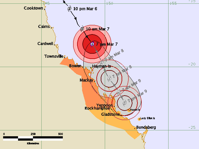
Severe Tropical Cyclone Hamish, a CATEGORY 5 CYCLONE, is located off the north
Queensland coast and at 10:00 pm EST was estimated to be 180 kilometres north
northeast of Hayman Is and 275 kilometres east northeast of Townsville, moving
southeast at 17 kilometres per hour.
Severe Tropical Cyclone Hamish poses a very significant threat to coastal and
island communities about the central Queensland coast. The cyclone is expected
to maintain a southeast track parallel to the coast during the next 24 to 48
hours.
Damaging wind gusts may affect coastal and island communities between Ayr and
Gladstone during the next 24 hours.
DESTRUCTIVE WINDS are expected to affect exposed coastal and island communities
between Bowen and Shoalwater Bay during the next 24 hours.
As the cyclone moves to the southeast, sea levels are expected to be elevated
above the normal tide along the coastline south of the cyclone. Large waves may
produce minor flooding along the foreshore. People living in areas likely to be
affected by this flooding should take measures to protect their property as much
as possible and be prepared to help their neighbours.
Areas of heavy rainfall may cause flooding in some coastal streams and rivers
between Bowen and Rockhampton during the next 24 hours.
Details of Severe Tropical Cyclone Hamish at 10:00 pm EST:
.Centre located near...... 18.5 degrees South 149.3 degrees East
.Location accuracy........ within 19 kilometres
.Recent movement.......... towards the southeast at 17 kilometres per hour
.Wind gusts near centre... 295 kilometres per hour
.Severity category........ 5
.Central pressure......... 930 hectoPascals
People between Ayr and Gladstone should immediately commence or continue
preparations, especially securing boats and property.
People between Gladstone and Hervey Bay should consider what action they will
need to take if the cyclone threat increases. If you are unsure about the
actions to be taken, information is available from your local government or
local State Emergency Service.
The next advice will be issued by 2:00 am EST Sunday 08 March
IDQP0005
Australian Government Bureau of Meteorology
Queensland
Tropical Cyclone Warning Centre
Media: Transmitters serving the area between Bowen and Mackay are requested to
USE the Standard Emergency Warning Signal before broadcasting the following
warning.
TOP PRIORITY
TROPICAL CYCLONE ADVICE NUMBER 17
Issued by the Bureau of Meteorology, Brisbane
Issued at 10:48pm on Saturday the 7th of March 2009
A Cyclone WARNING remains current for coastal and island communities from Ayr to
Gladstone. A Cyclone WATCH remains current for coastal and island communities
from Gladstone to Hervey Bay.
The Cyclone WATCH between Townsville and Ayr has been CANCELLED.
VERY DESTRUCTIVE WINDS, ELEVATED SEA LEVELS and LARGE WAVES are likely to impact
on the Whitsunday Islands during Sunday morning.
Severe Tropical Cyclone Hamish, a CATEGORY 5 CYCLONE, is located off the north
Queensland coast and at 10:00 pm EST was estimated to be 180 kilometres north
northeast of Hayman Is and 275 kilometres east northeast of Townsville, moving
southeast at 17 kilometres per hour.
Severe Tropical Cyclone Hamish poses a very significant threat to coastal and
island communities about the central Queensland coast. The cyclone is expected
to maintain a southeast track parallel to the coast during the next 24 to 48
hours.
Damaging wind gusts may affect coastal and island communities between Ayr and
Gladstone during the next 24 hours.
DESTRUCTIVE WINDS are expected to affect exposed coastal and island communities
between Bowen and Shoalwater Bay during the next 24 hours.
As the cyclone moves to the southeast, sea levels are expected to be elevated
above the normal tide along the coastline south of the cyclone. Large waves may
produce minor flooding along the foreshore. People living in areas likely to be
affected by this flooding should take measures to protect their property as much
as possible and be prepared to help their neighbours.
Areas of heavy rainfall may cause flooding in some coastal streams and rivers
between Bowen and Rockhampton during the next 24 hours.
Details of Severe Tropical Cyclone Hamish at 10:00 pm EST:
.Centre located near...... 18.5 degrees South 149.3 degrees East
.Location accuracy........ within 19 kilometres
.Recent movement.......... towards the southeast at 17 kilometres per hour
.Wind gusts near centre... 295 kilometres per hour
.Severity category........ 5
.Central pressure......... 930 hectoPascals
People between Ayr and Gladstone should immediately commence or continue
preparations, especially securing boats and property.
People between Gladstone and Hervey Bay should consider what action they will
need to take if the cyclone threat increases. If you are unsure about the
actions to be taken, information is available from your local government or
local State Emergency Service.
The next advice will be issued by 2:00 am EST Sunday 08 March
0 likes


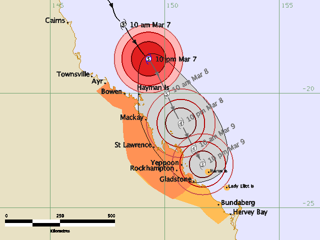
TROPICAL CYCLONE TECHNICAL BULLETIN: AUSTRALIA - EASTERN REGION
Issued by BRISBANE TROPICAL CYCLONE WARNING CENTRE
at: 1222 UTC 07/03/2009
Name: Severe Tropical Cyclone Hamish
Identifier: 17U
Data At: 1200 UTC
Latitude: 18.5S
Longitude: 149.3E
Location Accuracy: within 10 nm [19 km]
Movement Towards: southeast [145 deg]
Speed of Movement: 9 knots [17 km/h]
Maximum 10-Minute Wind: 115 knots [215 km/h]
Maximum 3-Second Wind Gust: 160 knots [295 km/h]
Central Pressure: 930 hPa
Radius of 34-knot winds NE quadrant: 120 nm [220 km]
Radius of 34-knot winds SE quadrant: 120 nm [220 km]
Radius of 34-knot winds SW quadrant: 120 nm [220 km]
Radius of 34-knot winds NW quadrant: 120 nm [220 km]
Radius of 48-knot winds NE quadrant: 70 nm [130 km]
Radius of 48-knot winds SE quadrant: 70 nm [130 km]
Radius of 48-knot winds SW quadrant: 70 nm [130 km]
Radius of 48-knot winds NW quadrant: 70 nm [130 km]
Radius of 64-knot winds: 45 nm [85 km]
Radius of Maximum Winds: 25 nm
Dvorak Intensity Code: T6.5/6.5/D1.5/12HRS
Pressure of outermost isobar: 1004 hPa
Radius of outermost closed isobar: 100 nm [185 km]
Storm Depth: Deep
FORECAST DATA
Date/Time : Location : Loc. Accuracy: Max Wind : Central Pressure
[UTC] : degrees : nm [km]: knots[km/h]: hPa
+12: 08/0000: 20.0S 150.1E: 040 [075]: 115 [215]: 930
+24: 08/1200: 21.3S 150.7E: 070 [130]: 110 [205]: 944
+36: 09/0000: 22.4S 151.3E: 105 [190]: 100 [180]: 949
+48: 09/1200: 23.1S 151.7E: 135 [250]: 085 [155]: 952
+60: 10/0000: 23.8S 151.9E: 185 [340]: 075 [135]: 958
+72: 10/1200: 24.3S 151.4E: 230 [425]: 050 [090]: 986
REMARKS:
Eye pattern with B surround, WMG eye with CMG surrounding ring. DT is 6.5. MET
is 6.0. DT used as final T. System expected to maintain intensity during the 12
to 24 hour period before undergoing a slow weakening under increasing deep layer
wind shear.
Copyright Commonwealth of Australia
==
The next bulletin for this system will be issued by: 07/1900 UTC by Brisbane
TCWC.
0 likes
-
CrazyC83
- Professional-Met

- Posts: 34316
- Joined: Tue Mar 07, 2006 11:57 pm
- Location: Deep South, for the first time!
Re: Coral Sea: HAMISH - Severe Tropical Cyclone
Chacor wrote:130 kt from JTWC at 12z.
Seems to be a good data compromise since it probably takes a little while to catch up to the satellite. Right now, I would say 135 kt.
0 likes
-
HURAKAN

- Professional-Met
- Posts: 46084
- Age: 39
- Joined: Thu May 20, 2004 4:34 pm
- Location: Key West, FL
- Contact:
Re: Coral Sea: HAMISH - Severe Tropical Cyclone

SUBJ: TROPICAL CYCLONE 18P (HAMISH) WARNING NR 005
WTPS31 PGTW 071500
1. TROPICAL CYCLONE 18P (HAMISH) WARNING NR 005
01 ACTIVE TROPICAL CYCLONE IN SOUTHPAC
MAX SUSTAINED WINDS BASED ON ONE-MINUTE AVERAGE
---
WARNING POSITION:
071200Z --- NEAR 18.5S 149.3E
MOVEMENT PAST SIX HOURS - 140 DEGREES AT 08 KTS
POSITION ACCURATE TO WITHIN 040 NM
POSITION BASED ON EYE FIXED BY SATELLITE
PRESENT WIND DISTRIBUTION:
MAX SUSTAINED WINDS - 130 KT, GUSTS 160 KT
WIND RADII VALID OVER OPEN WATER ONLY
RADIUS OF 064 KT WINDS - 050 NM NORTHEAST QUADRANT
050 NM SOUTHEAST QUADRANT
040 NM SOUTHWEST QUADRANT
040 NM NORTHWEST QUADRANT
RADIUS OF 050 KT WINDS - 070 NM NORTHEAST QUADRANT
065 NM SOUTHEAST QUADRANT
065 NM SOUTHWEST QUADRANT
065 NM NORTHWEST QUADRANT
RADIUS OF 034 KT WINDS - 130 NM NORTHEAST QUADRANT
110 NM SOUTHEAST QUADRANT
115 NM SOUTHWEST QUADRANT
125 NM NORTHWEST QUADRANT
REPEAT POSIT: 18.5S 149.3E
---
FORECASTS:
12 HRS, VALID AT:
080000Z --- 20.1S 150.3E
MAX SUSTAINED WINDS - 125 KT, GUSTS 150 KT
WIND RADII VALID OVER OPEN WATER ONLY
RADIUS OF 064 KT WINDS - 020 NM NORTHEAST QUADRANT
020 NM SOUTHEAST QUADRANT
020 NM SOUTHWEST QUADRANT
020 NM NORTHWEST QUADRANT
RADIUS OF 050 KT WINDS - 035 NM NORTHEAST QUADRANT
035 NM SOUTHEAST QUADRANT
030 NM SOUTHWEST QUADRANT
030 NM NORTHWEST QUADRANT
RADIUS OF 034 KT WINDS - 085 NM NORTHEAST QUADRANT
085 NM SOUTHEAST QUADRANT
075 NM SOUTHWEST QUADRANT
075 NM NORTHWEST QUADRANT
VECTOR TO 24 HR POSIT: 155 DEG/ 09 KTS
---
24 HRS, VALID AT:
081200Z --- 21.7S 151.1E
MAX SUSTAINED WINDS - 115 KT, GUSTS 140 KT
WIND RADII VALID OVER OPEN WATER ONLY
RADIUS OF 064 KT WINDS - 020 NM NORTHEAST QUADRANT
020 NM SOUTHEAST QUADRANT
020 NM SOUTHWEST QUADRANT
020 NM NORTHWEST QUADRANT
RADIUS OF 050 KT WINDS - 040 NM NORTHEAST QUADRANT
040 NM SOUTHEAST QUADRANT
035 NM SOUTHWEST QUADRANT
035 NM NORTHWEST QUADRANT
RADIUS OF 034 KT WINDS - 085 NM NORTHEAST QUADRANT
085 NM SOUTHEAST QUADRANT
075 NM SOUTHWEST QUADRANT
075 NM NORTHWEST QUADRANT
VECTOR TO 36 HR POSIT: 155 DEG/ 09 KTS
---
36 HRS, VALID AT:
090000Z --- 23.4S 152.0E
MAX SUSTAINED WINDS - 100 KT, GUSTS 125 KT
WIND RADII VALID OVER OPEN WATER ONLY
RADIUS OF 064 KT WINDS - 025 NM NORTHEAST QUADRANT
025 NM SOUTHEAST QUADRANT
025 NM SOUTHWEST QUADRANT
025 NM NORTHWEST QUADRANT
RADIUS OF 050 KT WINDS - 045 NM NORTHEAST QUADRANT
045 NM SOUTHEAST QUADRANT
040 NM SOUTHWEST QUADRANT
040 NM NORTHWEST QUADRANT
RADIUS OF 034 KT WINDS - 095 NM NORTHEAST QUADRANT
095 NM SOUTHEAST QUADRANT
085 NM SOUTHWEST QUADRANT
085 NM NORTHWEST QUADRANT
VECTOR TO 48 HR POSIT: 155 DEG/ 08 KTS
---
EXTENDED OUTLOOK:
48 HRS, VALID AT:
091200Z --- 24.8S 152.7E
MAX SUSTAINED WINDS - 080 KT, GUSTS 100 KT
WIND RADII VALID OVER OPEN WATER ONLY
RADIUS OF 064 KT WINDS - 030 NM NORTHEAST QUADRANT
030 NM SOUTHEAST QUADRANT
030 NM SOUTHWEST QUADRANT
030 NM NORTHWEST QUADRANT
RADIUS OF 050 KT WINDS - 050 NM NORTHEAST QUADRANT
050 NM SOUTHEAST QUADRANT
045 NM SOUTHWEST QUADRANT
045 NM NORTHWEST QUADRANT
RADIUS OF 034 KT WINDS - 100 NM NORTHEAST QUADRANT
100 NM SOUTHEAST QUADRANT
090 NM SOUTHWEST QUADRANT
090 NM NORTHWEST QUADRANT
---
REMARKS:
071500Z POSITION NEAR 18.9S 149.6E.
TROPICAL CYCLONE (TC) 18P (HAMISH), LOCATED APPROXIMATELY 585 NM
NORTH-NORTHWEST OF BRISBANE, AUSTRALIA, HAS TRACKED SOUTHEASTWARD
AT 08 KNOTS OVER THE PAST 06 HOURS. THE CYCLONE HAS RAPIDLY
INTENSIFIED OVER THE PAST 12 HOURS WITH DVORAK SATELLITE INTENSITY
ESTIMATES FROM PGTW, KNES, AND ABRF, INDICATING AT THE WEAKEST
A 130 KNOT SYSTEM. THE TC WILL CONTINUE TO TRACK ALONG THE EAST
COAST OF AUSTRALIA UNDER THE STEERING INFLUENCE OF DEEP LAYER
RIDGING TO THE EAST WHILE WEAKENING. INCREASED VERTICAL WIND SHEAR
AND LAND INTERACTION WILL INITIATE THIS WEAKENING. GREATER WEAKENING
IS EXPECTED NEARER TO TAU 24, AND THROUGH THE DURATION OF THE
FORECAST PERIOD, AS THE SYSTEM MOVES EVEN CLOSER TO LAND AND A
BRANCH OF THE SUBTROPICAL JET. MAXIMUM SIGNIFICANT WAVE HEIGHT AT
071200Z IS 19 FEET. NEXT WARNINGS AT 080300Z AND 081500Z.
//
NNNN
0 likes
Who is online
Users browsing this forum: No registered users and 45 guests