ATL: TROPICAL STORM BILL (03L)

Moderator: S2k Moderators

Message
Author
User avatar
caribepr
Category 5
Category 5
Posts: 1794
Joined: Fri Sep 05, 2003 10:43 pm
Location: Culebra, PR 18.33 65.33

Re:

#801 Postby caribepr » Fri Aug 14, 2009 7:35 pm

KWT wrote:Yep, the best hope for you guys is the 18z is right and the system stays just enough to the south but unless a ECM occurs it does seem that your region will at least get some effects...though to be fair its still a little early yet to know whats going to happen in that respect.


It's early if you live in the UK! I'm one of those people that likes to have things down to a three hour wrap up this time of year...leaves more time for deciding where to spend a storm and who's bringing what 8-)
0 likes   

jinftl
Category 5
Category 5
Posts: 4312
Joined: Tue Aug 31, 2004 4:47 pm
Location: fort lauderdale, fl

Re: ATL: Invest 90L

#802 Postby jinftl » Fri Aug 14, 2009 7:36 pm

This system has essentially had unwavering model support (both across individual model runs and between different models) for days now.....that is not something we see often. If this doesn't go ahead and develop as has been forecast run after run....models lose significant credibility. That said, I fully expect the models to retain their credibility just fine here.
0 likes   

User avatar
brunota2003
S2K Supporter
S2K Supporter
Posts: 9476
Age: 34
Joined: Sat Jul 30, 2005 9:56 pm
Location: Stanton, KY...formerly Havelock, NC
Contact:

Re: ATL: Invest 90L Models

#803 Postby brunota2003 » Fri Aug 14, 2009 7:36 pm

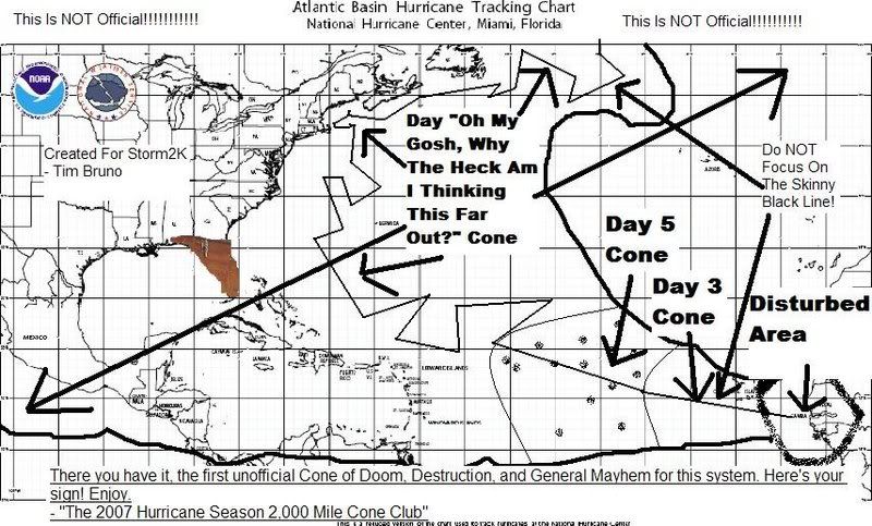
jinftl wrote:Add in the 1000+ mile margin of error over 10 days out....and the love affair is a bit less exclusive to the big easy!

micktooth wrote:Hate to say it, its so far out, but the GFS has been in love with New Orleans for a while as well! Just my 2 cents, I used to live there until Katrina, now I'm safe in Colorado. :D

I think it is time to pull out an oldy, but still VERY relevant, drawing I made 2 years ago:

Image
0 likes   

Derek Ortt

#804 Postby Derek Ortt » Fri Aug 14, 2009 7:36 pm

ran the ARW for 12Z... also got a destructive hurricane heading to the NE Carib
0 likes   

tolakram
Admin
Admin
Posts: 20009
Age: 62
Joined: Sun Aug 27, 2006 8:23 pm
Location: Florence, KY (name is Mark)

Re: ATL: Invest 90L

#805 Postby tolakram » Fri Aug 14, 2009 7:37 pm

jinftl wrote:This system has essentially had unwavering model support (both across individual model runs and between different models) for days now.....that is not something we see often. If this doesn't go ahead and develop as has been forecast run after run....models lose significant credibility. That said, I fully expect the models to retain their credibility just fine here.


If nothing else it will be interesting to see how well the models have done with this. All of them predicting a strong storm in the islands. I just hope beyond hope that the shear saves the day before it gets there.
0 likes   

CrazyC83
Professional-Met
Professional-Met
Posts: 34002
Joined: Tue Mar 07, 2006 11:57 pm
Location: Deep South, for the first time!

#806 Postby CrazyC83 » Fri Aug 14, 2009 7:38 pm

Oops, incorrect storm.
Last edited by CrazyC83 on Fri Aug 14, 2009 7:40 pm, edited 1 time in total.
0 likes   

Derek Ortt

#807 Postby Derek Ortt » Fri Aug 14, 2009 7:40 pm

THATS AN EASTERN PACIFIC INVEST!!!!!
0 likes   

User avatar
cycloneye
Admin
Admin
Posts: 145336
Age: 68
Joined: Thu Oct 10, 2002 10:54 am
Location: San Juan, Puerto Rico

Re:

#808 Postby cycloneye » Fri Aug 14, 2009 7:40 pm

CrazyC83 wrote:BT at 1800Z: REVISED TO TD

EP, 90, 2009080918, , BEST, 0, 140N, 1200W, 30, 1007, TD


That is in EPAC.
0 likes   

User avatar
cycloneye
Admin
Admin
Posts: 145336
Age: 68
Joined: Thu Oct 10, 2002 10:54 am
Location: San Juan, Puerto Rico

Re:

#809 Postby cycloneye » Fri Aug 14, 2009 7:40 pm

CrazyC83 wrote:BT at 1800Z: REVISED TO TD

EP, 90, 2009080918, , BEST, 0, 140N, 1200W, 30, 1007, TD


That is in EPAC.
0 likes   

CrazyC83
Professional-Met
Professional-Met
Posts: 34002
Joined: Tue Mar 07, 2006 11:57 pm
Location: Deep South, for the first time!

#810 Postby CrazyC83 » Fri Aug 14, 2009 7:41 pm

Sorry, I realized that after the fact. Corrected.
0 likes   

paintplaye
Category 1
Category 1
Posts: 380
Joined: Sun Jul 20, 2008 11:25 pm

Re:

#811 Postby paintplaye » Fri Aug 14, 2009 7:41 pm

Derek Ortt wrote:THATS AN EASTERN PACIFIC INVEST!!!!!


:eek: :lol: Wow...
0 likes   

User avatar
sunnyday
Category 5
Category 5
Posts: 1590
Joined: Thu Sep 04, 2003 8:16 pm

Re: ATL: Invest 90L

#812 Postby sunnyday » Fri Aug 14, 2009 7:43 pm

Every time I'm out of the house for a good while and come back to check on the invest, I see that it is just that--still an invest. I really think this one won't make it, but I have nothing to go on except a feeling. Most others seem to think the invest will become a large storm. Time will tell. 8-)
0 likes   

tolakram
Admin
Admin
Posts: 20009
Age: 62
Joined: Sun Aug 27, 2006 8:23 pm
Location: Florence, KY (name is Mark)

Re: ATL: Invest 90L

#813 Postby tolakram » Fri Aug 14, 2009 7:44 pm

sunnyday, update your profile and tell us where you are. :)
0 likes   

jinftl
Category 5
Category 5
Posts: 4312
Joined: Tue Aug 31, 2004 4:47 pm
Location: fort lauderdale, fl

Re: ATL: Invest 90L Models

#814 Postby jinftl » Fri Aug 14, 2009 7:44 pm

Does 90L have a brother following in its footsteps???

And the entire atlantic-caribbean-gom coastlines just went <gulp> (what el nino season? maybe it does only take 1...or 2)

Image
0 likes   

Sanibel
Category 5
Category 5
Posts: 10375
Joined: Mon Aug 30, 2004 11:06 pm
Location: Offshore SW Florida

Re: ATL: Invest 90L

#815 Postby Sanibel » Fri Aug 14, 2009 7:45 pm

That's what I was going to post Tolakram. That we could learn the idiosyncrasies of the models by seeing what actually occurs and understanding how the models interpreted it. My previous understanding is that the models are interpreting the long range according to the present synoptic and can be way off on what actually occurs 10 days further on.
0 likes   

User avatar
cycloneye
Admin
Admin
Posts: 145336
Age: 68
Joined: Thu Oct 10, 2002 10:54 am
Location: San Juan, Puerto Rico

Re: ATL: Invest 90L

#816 Postby cycloneye » Fri Aug 14, 2009 7:46 pm

00 UTC Best Track

No TD yet.

AL, 90, 2009081500, , BEST, 0, 125N, 305W, 25, 1007, DB

ftp://ftp.tpc.ncep.noaa.gov/atcf/tcweb/ ... 009.invest
0 likes   

User avatar
sunnyday
Category 5
Category 5
Posts: 1590
Joined: Thu Sep 04, 2003 8:16 pm

Re: ATL: Invest 90L

#817 Postby sunnyday » Fri Aug 14, 2009 7:46 pm

Let's just say Roll Tide as a hint as to where we live. 8-)
0 likes   

jinftl
Category 5
Category 5
Posts: 4312
Joined: Tue Aug 31, 2004 4:47 pm
Location: fort lauderdale, fl

Re: ATL: Invest 90L

#818 Postby jinftl » Fri Aug 14, 2009 7:48 pm

Models runs that show landfalls closest to where one lives are the ones given the most credence...thankfully we have the nhc to steer us right.


Sanibel wrote:That's what I was going to post Tolakram. That we could learn the idiosyncrasies of the models by seeing what actually occurs and understanding how the models interpreted it. My previous understanding is that the models are interpreting the long range according to the present synoptic and can be way off on what actually occurs 10 days further on.
0 likes   

User avatar
cycloneye
Admin
Admin
Posts: 145336
Age: 68
Joined: Thu Oct 10, 2002 10:54 am
Location: San Juan, Puerto Rico

Re: ATL: Invest 90L Models

#819 Postby cycloneye » Fri Aug 14, 2009 7:48 pm

00 UTC Bam Models

Moving west at 16kts.

WHXX01 KWBC 150046
CHGHUR
TROPICAL CYCLONE GUIDANCE MESSAGE
NWS TPC/NATIONAL HURRICANE CENTER MIAMI FL
0046 UTC SAT AUG 15 2009

DISCLAIMER...NUMERICAL MODELS ARE SUBJECT TO LARGE ERRORS.
PLEASE REFER TO NHC OFFICIAL FORECASTS FOR TROPICAL CYCLONE
AND SUBTROPICAL CYCLONE INFORMATION.

ATLANTIC OBJECTIVE AIDS FOR

DISTURBANCE INVEST (AL902009) 20090815 0000 UTC

...00 HRS... ...12 HRS... ...24 HRS. .. ...36 HRS...
090815 0000 090815 1200 090816 0000 090816 1200

LAT LON LAT LON LAT LON LAT LON
BAMS 12.5N 30.5W 12.7N 33.8W 13.0N 37.5W 12.7N 41.6W
BAMD 12.5N 30.5W 12.7N 33.4W 12.9N 36.7W 13.1N 40.5W
BAMM 12.5N 30.5W 12.7N 33.6W 12.9N 37.1W 12.9N 41.0W
LBAR 12.5N 30.5W 12.6N 34.0W 13.0N 38.1W 13.4N 42.5W
SHIP 25KTS 30KTS 40KTS 52KTS
DSHP 25KTS 30KTS 40KTS 52KTS

...48 HRS... ...72 HRS... ...96 HRS. .. ..120 HRS...
090817 0000 090818 0000 090819 0000 090820 0000

LAT LON LAT LON LAT LON LAT LON
BAMS 12.4N 45.4W 12.2N 51.0W 14.3N 55.3W 17.9N 61.9W
BAMD 13.4N 44.4W 13.6N 51.7W 13.7N 57.2W 15.5N 61.5W
BAMM 12.9N 44.8W 12.8N 51.1W 14.1N 55.5W 17.3N 60.8W
LBAR 14.2N 47.1W 14.7N 55.4W 14.8N 56.2W .0N .0W
SHIP 62KTS 83KTS 93KTS 96KTS
DSHP 62KTS 83KTS 93KTS 96KTS

...INITIAL CONDITIONS...
LATCUR = 12.5N LONCUR = 30.5W DIRCUR = 270DEG SPDCUR = 16KT
LATM12 = 12.2N LONM12 = 26.8W DIRM12 = 281DEG SPDM12 = 18KT
LATM24 = 11.6N LONM24 = 24.0W
WNDCUR = 25KT RMAXWD = 75NM WNDM12 = 25KT
CENPRS = 1007MB OUTPRS = 1011MB OUTRAD = 200NM SDEPTH = M
RD34NE = 0NM RD34SE = 0NM RD34SW = 0NM RD34NW = 0NM
0 likes   

User avatar
sunnyday
Category 5
Category 5
Posts: 1590
Joined: Thu Sep 04, 2003 8:16 pm

Re: ATL: Invest 90L

#820 Postby sunnyday » Fri Aug 14, 2009 7:49 pm

OO UTC says no td yet. See what I mean? 8-)
0 likes   


Return to “2009”

Who is online

Users browsing this forum: No registered users and 5 guests