ATL: TROPICAL LOW ex-FRED (ex-07L)
Moderator: S2k Moderators
-
ozonepete
- Professional-Met

- Posts: 4743
- Joined: Mon Sep 07, 2009 3:23 pm
- Location: From Ozone Park, NYC / Now in Brooklyn, NY
Re: ATL: TROPICAL DEPRESSION FRED (07L)
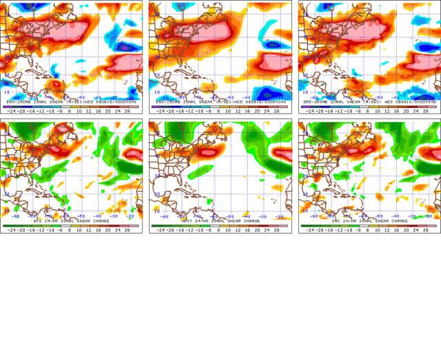
3-panel shear forecast (GFS NAVY CMC from left to right) for tomorrow evening. It's forecast to be even less after that. I'm not sayin' anything, just showing a chart. 
0 likes
-
cycloneye

- Admin

- Posts: 149220
- Age: 69
- Joined: Thu Oct 10, 2002 10:54 am
- Location: San Juan, Puerto Rico
Re: ATL: TROPICAL DEPRESSION FRED (07L)
Best Track continues to plot ex Fred.
AL, 07, 2009091500, , BEST, 0, 191N, 419W, 25, 1008, LO
ftp://ftp.tpc.ncep.noaa.gov/atcf/tcweb/ ... 009.invest
AL, 07, 2009091500, , BEST, 0, 191N, 419W, 25, 1008, LO
ftp://ftp.tpc.ncep.noaa.gov/atcf/tcweb/ ... 009.invest
0 likes


Re: ATL: TROPICAL DEPRESSION FRED (07L)
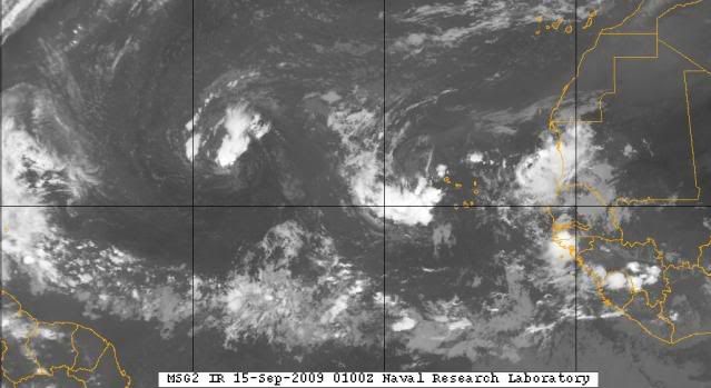
Fred refuses to quit refiring convection. Even got some south and west of the center now. Will be interesting to watch.
0 likes
-
ozonepete
- Professional-Met
- Posts: 4743
- Joined: Mon Sep 07, 2009 3:23 pm
- Location: From Ozone Park, NYC / Now in Brooklyn, NY
Re: ATL: TROPICAL DEPRESSION FRED (07L)
Fred doesn't look so dead right now. (Neither do those two easterly waves behind him.)
0 likes

Re: ATL: TROPICAL DEPRESSION FRED (07L)
ozonepete wrote:Fred doesn't look so dead right now. (Neither do those two easterly waves behind him.)
I was just over there looking at that...just observing, of course...
0 likes
-
cycloneye
- Admin
- Posts: 149220
- Age: 69
- Joined: Thu Oct 10, 2002 10:54 am
- Location: San Juan, Puerto Rico
Re: ATL: TROPICAL DEPRESSION FRED (07L)
Convection is now over circulation.The other thing to the right has its own thread at Talking Tropics forum.

0 likes


Re: ATL: TROPICAL DEPRESSION FRED (07L)
Tomorrow will be a crucial day regarding whether Fred redevelops or not. Shear will decrease, but dry air will remain a problem. If convection can remain for most of the day, it´s got a chance to expel enough dry air.
0 likes
-
gatorcane

- S2K Supporter

- Posts: 23708
- Age: 48
- Joined: Sun Mar 13, 2005 3:54 pm
- Location: Boca Raton, FL
Shear as analyzed by CIMSS, looks like it drops off starting this time tomorrow and upper-level winds finally improve for the next couple of days. Let's see what it has.
http://cimss.ssec.wisc.edu/tropic/real- ... g8shr.html
Also, the SSTs increase from 27C to 28C overnight tonight, so that may help development. You can see the SSTs by clicking this link and clicking on SSTs box:
http://www.ssd.noaa.gov/goes/east/tatl/loop-avn.html
But the dry air may be enough to keep it from developing at all.
Last edited by gatorcane on Mon Sep 14, 2009 9:59 pm, edited 1 time in total.
0 likes
-
Blown Away

- S2K Supporter
- Posts: 10253
- Joined: Wed May 26, 2004 6:17 am
Re: ATL: TROPICAL DEPRESSION FRED (07L)
http://www.ssd.noaa.gov/goes/flt/t1/loop-wv.html
0 likes
-
gatorcane
- S2K Supporter
- Posts: 23708
- Age: 48
- Joined: Sun Mar 13, 2005 3:54 pm
- Location: Boca Raton, FL
Re: ATL: TROPICAL DEPRESSION FRED (07L)
Blown_away wrote::uarrow: One problem, lots of dry air being ingested for the next few days.
http://www.ssd.noaa.gov/goes/flt/t1/loop-wv.html
noted just as you posted this (I edited the post):)
0 likes
-
ozonepete
- Professional-Met
- Posts: 4743
- Joined: Mon Sep 07, 2009 3:23 pm
- Location: From Ozone Park, NYC / Now in Brooklyn, NY
Re: ATL: TROPICAL DEPRESSION FRED (07L)
Blown_away wrote::uarrow: One problem, lots of dry air being ingested for the next few days.
http://www.ssd.noaa.gov/goes/flt/t1/loop-wv.html
Remember that those water vapor satellites from NOAA show upper level dry air as well, which can mask what's going on at mid-levels. And it's the mid-level dry air that hurts a Tropical cyclone. The upper level water vapor is not nearly as important. Here's the mid-level water vapor from CIMSS, and it actually doesn't look bad at all and has improved from yesterday - the driest air is now to its south.

0 likes
Re: ATL: TROPICAL DEPRESSION FRED (07L)
Is that shear-induced or a refire?
Sometimes conditions finally change. Who knows?
Sometimes conditions finally change. Who knows?
0 likes
-
HURAKAN

- Professional-Met
- Posts: 46084
- Age: 39
- Joined: Thu May 20, 2004 4:34 pm
- Location: Key West, FL
- Contact:
Re: ATL: TROPICAL DEPRESSION FRED (07L)
666
ABNT20 KNHC 151148
TWOAT
TROPICAL WEATHER OUTLOOK
NWS TPC/NATIONAL HURRICANE CENTER MIAMI FL
800 AM EDT TUE SEP 15 2009
FOR THE NORTH ATLANTIC...CARIBBEAN SEA AND THE GULF OF MEXICO...
SHOWERS AND THUNDERSTORMS ASSOCIATED WITH THE REMNANTS OF FRED
LOCATED ABOUT 1100 MILES EAST OF THE NORTHERN LEEWARD ISLANDS HAVE
INCREASED THIS MORNING. ENVIRONMENTAL CONDITIONS COULD BECOME
MARGINALLY CONDUCIVE FOR RE-DEVELOPMENT...AND THERE IS A LOW
CHANCE...LESS THAN 30 PERCENT...OF THIS SYSTEM BECOMING A TROPICAL
CYCLONE DURING THE NEXT 48 HOURS. ADDITIONAL INFORMATION ON THIS
SYSTEM CAN BE FOUND IN HIGH SEAS FORECASTS ISSUED BY THE NATIONAL
WEATHER SERVICE...UNDER AWIPS HEADER NFDHSFAT1 AND WMO HEADER
FZNT01 KWBC.
A TROPICAL WAVE LOCATED A COUPLE HUNDRED MILES WEST OF THE CAPE
VERDE ISLANDS IS PRODUCING AN AREA OF DISORGANIZED SHOWERS AND
THUNDERSTORMS. DEVELOPMENT...IF ANY...OF THIS SYSTEM IS EXPECTED
TO BE SLOW TO OCCUR. THERE IS A LOW CHANCE...LESS THAN 30
PERCENT...OF THIS SYSTEM BECOMING A TROPICAL CYCLONE DURING THE
NEXT 48 HOURS.
ELSEWHERE...TROPICAL CYCLONE FORMATION IS NOT EXPECTED DURING THE
NEXT 48 HOURS.
$$
FORECASTER BROWN
0 likes
-
Blown Away
- S2K Supporter
- Posts: 10253
- Joined: Wed May 26, 2004 6:17 am
-
jlauderdal
- S2K Supporter
- Posts: 7240
- Joined: Wed May 19, 2004 5:46 am
- Location: NE Fort Lauderdale
- Contact:
Re: ATL: TROPICAL DEPRESSION FRED (07L)
cycloneye wrote:Change of tune.
our buddies are on full alert

0 likes
-
gatorcane
- S2K Supporter
- Posts: 23708
- Age: 48
- Joined: Sun Mar 13, 2005 3:54 pm
- Location: Boca Raton, FL
Re: ATL: TROPICAL DEPRESSION FRED (07L)
cycloneye wrote:Change of tune.
Of course, that is really no surprise from what I see also (as I noted last night). Conditions have become marginally favorable. UL winds are better, SSTs are higher, but dry air is still a problem.
0 likes
-
tolakram
- Admin
- Posts: 20176
- Age: 62
- Joined: Sun Aug 27, 2006 8:23 pm
- Location: Florence, KY (name is Mark)
Re: ATL: TROPICAL DEPRESSION FRED (07L)
Looks to be under an upper low. Stranger things have happened but ....

0 likes
-
gatorcane
- S2K Supporter
- Posts: 23708
- Age: 48
- Joined: Sun Mar 13, 2005 3:54 pm
- Location: Boca Raton, FL
GFS really does not like re-generation of Fred at this time. Last several runs completely drop it.
Here is the 06Z:
http://www.nco.ncep.noaa.gov/pmb/nwprod ... el_l.shtml
Here is the 06Z:
http://www.nco.ncep.noaa.gov/pmb/nwprod ... el_l.shtml
0 likes
Who is online
Users browsing this forum: No registered users and 7 guests