
What do you mean? wind shear if forcast to be pretty high through tomorrow at least, thursday should see shear relax, or so i have been lead to belive by the pre mets here,
where can i find the sat for this?
ATL: TROPICAL LOW ex-FRED (ex-07L)
Moderator: S2k Moderators
-
Aric Dunn
- Category 5

- Posts: 21238
- Age: 43
- Joined: Sun Sep 19, 2004 9:58 pm
- Location: Ready for the Chase.
- Contact:
Re: ATL: TROPICAL DEPRESSION FRED (07L)
KUEFC wrote:What do you mean? wind shear if forcast to be pretty high through tomorrow at least, thursday should see shear relax, or so i have been lead to belive by the pre mets here,
where can i find the sat for this?
shear is down to to less than 15kts .. but its under a upper low so there is little divergence aloft to help with convection but its should still allow convection to maintain its self which could help it re develop..

0 likes
-
Shewtinstar
- Tropical Low

- Posts: 32
- Joined: Wed Aug 26, 2009 10:01 am
Re: Re:
jlauderdal wrote:Shewtinstar wrote:So am I understanding this right? NHC is saying Fred could regenerate, but it's a low chance that it will do so within 48 hrs? That means after the 48 hr window it could come back again?
it means they think there is less than a 30% chance it will become a tropical cyclone in the next 48 hours. It means that we will find out at the next forecast(every hours) we will find out what they think might happen in the next 48 hour period.
I get the feeling some people including our local media think that oh well there is a less than a 30% chance it will ever develop so lets all feel real safe that nothing will ever happen.
That's exactly what I think. We need to take a look at the big picture and not the 48 hr window.
0 likes
-
wxman57

- Moderator-Pro Met

- Posts: 23171
- Age: 68
- Joined: Sat Jun 21, 2003 8:06 pm
- Location: Houston, TX (southwest)
Re: ATL: TROPICAL DEPRESSION FRED (07L)
Shouldn't this discussion be in the Talkin' Tropics area, as Fred is no longer an active storm or an invest?
0 likes
-
brunota2003

- S2K Supporter

- Posts: 9476
- Age: 35
- Joined: Sat Jul 30, 2005 9:56 pm
- Location: Stanton, KY...formerly Havelock, NC
- Contact:
Re: ATL: TROPICAL DEPRESSION FRED (07L)
wxman57 wrote:Shouldn't this discussion be in the Talkin' Tropics area, as Fred is no longer an active storm or an invest?
See:
cycloneye wrote:Why is this still on the Active Storms?
First,Best Track is continuing to release the plots every six hours like they normally do when systems are invest and second,NHC is still mentioning the system.
0 likes
-
brunota2003
- S2K Supporter
- Posts: 9476
- Age: 35
- Joined: Sat Jul 30, 2005 9:56 pm
- Location: Stanton, KY...formerly Havelock, NC
- Contact:
Re: ATL: TROPICAL DEPRESSION FRED (07L)
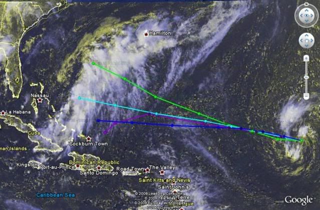
Whatever Fred is going to do, he better do it quick...this is the QS image from this morning both myself and Dr. Masters referenced to earlier:

0 likes

-
HURAKAN

- Professional-Met

- Posts: 46084
- Age: 39
- Joined: Thu May 20, 2004 4:34 pm
- Location: Key West, FL
- Contact:
Re: ATL: TROPICAL DEPRESSION FRED (07L)
418
ABNT20 KNHC 151745
TWOAT
TROPICAL WEATHER OUTLOOK
NWS TPC/NATIONAL HURRICANE CENTER MIAMI FL
200 PM EDT TUE SEP 15 2009
FOR THE NORTH ATLANTIC...CARIBBEAN SEA AND THE GULF OF MEXICO...
SHOWERS AND THUNDERSTORMS ASSOCIATED WITH THE REMNANTS OF FRED
LOCATED ABOUT 1020 MILES EAST OF THE NORTHERN LEEWARD ISLANDS REMAIN
DISORGANIZED. ENVIRONMENTAL CONDITIONS COULD BECOME MARGINALLY
CONDUCIVE FOR RE-DEVELOPMENT...AND THERE IS A LOW CHANCE...LESS
THAN 30 PERCENT...OF THIS SYSTEM BECOMING A TROPICAL CYCLONE DURING
THE NEXT 48 HOURS. ADDITIONAL INFORMATION ON THIS SYSTEM CAN BE
FOUND IN HIGH SEAS FORECASTS ISSUED BY THE NATIONAL WEATHER
SERVICE...UNDER AWIPS HEADER NFDHSFAT1 AND WMO HEADER FZNT01 KWBC.
A TROPICAL WAVE LOCATED A COUPLE HUNDRED MILES WEST OF THE CAPE
VERDE ISLANDS IS PRODUCING AN AREA OF DISORGANIZED SHOWERS AND
THUNDERSTORMS. DEVELOPMENT...IF ANY...OF THIS SYSTEM IS EXPECTED
TO BE SLOW TO OCCUR. THERE IS A LOW CHANCE...LESS THAN 30
PERCENT...OF THIS SYSTEM BECOMING A TROPICAL CYCLONE DURING THE
NEXT 48 HOURS.
A LARGE AREA OF DISORGANIZED SHOWERS AND THUNDERSTORMS EXTEND FROM
THE SOUTHEASTERN BAHAMAS NORTHEASTWARD TO NEAR BERMUDA. THIS
ACTIVITY IS ASSOCIATED WITH WEAK LOW PRESSURE AREA ALONG A FRONTAL
SYSTEM. UPPER-LEVEL WINDS ARE EXPECTED TO REMAIN UNFAVORABLE FOR
SIGNIFICANT DEVELOPMENT...AND THERE IS A LOW CHANCE...LESS THAN 30
PERCENT...OF THIS SYSTEM BECOMING A TROPICAL OR SUBTROPICAL CYCLONE
DURING THE NEXT 48 HOURS.
ELSEWHERE...TROPICAL CYCLONE FORMATION IS NOT EXPECTED DURING THE
NEXT 48 HOURS.
$$
FORECASTER BLAKE
0 likes
-
jlauderdal
- S2K Supporter
- Posts: 7240
- Joined: Wed May 19, 2004 5:46 am
- Location: NE Fort Lauderdale
- Contact:
Re: ATL: TROPICAL DEPRESSION FRED (07L)
wxman57 wrote:Shouldn't this discussion be in the Talkin' Tropics area, as Fred is no longer an active storm or an invest?
no because you never posted "Bones"
0 likes
-
jasons2k

- Storm2k Executive

- Posts: 8290
- Age: 52
- Joined: Wed Jul 06, 2005 12:32 pm
- Location: The Woodlands, TX
Re: ATL: TROPICAL DEPRESSION FRED (07L)
Reminder to all:
If you have a question about why something is in a particular forum, merging threads, etc., please PM a moderator.
Asking these kinds of questions on the open forum just clutters the board, especially when then 5 more people chime in.
FWIW - we do have set guidelines for these things.
If you have a question about why something is in a particular forum, merging threads, etc., please PM a moderator.
Asking these kinds of questions on the open forum just clutters the board, especially when then 5 more people chime in.
FWIW - we do have set guidelines for these things.
0 likes


-
cycloneye

- Admin
- Posts: 149222
- Age: 69
- Joined: Thu Oct 10, 2002 10:54 am
- Location: San Juan, Puerto Rico
Re: ATL: TROPICAL DEPRESSION FRED (07L)
18 UTC Best Track
AL, 07, 2009091518, , BEST, 0, 201N, 468W, 30, 1008, LO
ftp://ftp.tpc.ncep.noaa.gov/atcf/tcweb/ ... 009.invest
AL, 07, 2009091518, , BEST, 0, 201N, 468W, 30, 1008, LO
ftp://ftp.tpc.ncep.noaa.gov/atcf/tcweb/ ... 009.invest
0 likes
-
cycloneye
- Admin
- Posts: 149222
- Age: 69
- Joined: Thu Oct 10, 2002 10:54 am
- Location: San Juan, Puerto Rico
Re: ATL: TROPICAL DEPRESSION FRED (07L) - Computer Models
Bam Models running again for Fred
851
WHXX01 KWBC 151842
CHGHUR
TROPICAL CYCLONE GUIDANCE MESSAGE
NWS TPC/NATIONAL HURRICANE CENTER MIAMI FL
1842 UTC TUE SEP 15 2009
DISCLAIMER...NUMERICAL MODELS ARE SUBJECT TO LARGE ERRORS.
PLEASE REFER TO NHC OFFICIAL FORECASTS FOR TROPICAL CYCLONE
AND SUBTROPICAL CYCLONE INFORMATION.
ATLANTIC OBJECTIVE AIDS FOR
DISTURBANCE FRED (AL072009) 20090915 1800 UTC
...00 HRS... ...12 HRS... ...24 HRS. .. ...36 HRS...
090915 1800 090916 0600 090916 1800 090917 0600
LAT LON LAT LON LAT LON LAT LON
BAMS 20.1N 46.7W 20.7N 49.8W 21.9N 52.9W 22.9N 55.9W
BAMD 20.1N 46.7W 20.9N 49.0W 21.7N 51.6W 22.3N 54.2W
BAMM 20.1N 46.7W 20.9N 49.3W 21.8N 52.3W 22.6N 55.3W
LBAR 20.1N 46.7W 20.9N 49.4W 21.8N 52.4W 22.5N 55.6W
SHIP 30KTS 34KTS 40KTS 44KTS
DSHP 30KTS 34KTS 40KTS 44KTS
...48 HRS... ...72 HRS... ...96 HRS. .. ..120 HRS...
090917 1800 090918 1800 090919 1800 090920 1800
LAT LON LAT LON LAT LON LAT LON
BAMS 24.1N 58.9W 25.9N 63.7W 27.7N 67.2W 29.2N 71.0W
BAMD 22.6N 56.8W 23.0N 61.9W 23.3N 66.3W 23.4N 70.1W
BAMM 23.3N 58.2W 24.2N 63.6W 25.0N 68.2W 25.6N 72.4W
LBAR 23.1N 58.6W 24.2N 64.4W 23.2N 68.2W 22.2N 69.3W
SHIP 48KTS 52KTS 56KTS 59KTS
DSHP 48KTS 52KTS 56KTS 59KTS
...INITIAL CONDITIONS...
LATCUR = 20.1N LONCUR = 46.7W DIRCUR = 283DEG SPDCUR = 16KT
LATM12 = 19.3N LONM12 = 43.3W DIRM12 = 282DEG SPDM12 = 15KT
LATM24 = 19.1N LONM24 = 40.5W
WNDCUR = 30KT RMAXWD = 45NM WNDM12 = 25KT
CENPRS = 1010MB OUTPRS = 1012MB OUTRAD = 210NM SDEPTH = S
RD34NE = 0NM RD34SE = 0NM RD34SW = 0NM RD34NW = 0NM
0 likes
-
HURAKAN
- Professional-Met
- Posts: 46084
- Age: 39
- Joined: Thu May 20, 2004 4:34 pm
- Location: Key West, FL
- Contact:
Re: ATL: TROPICAL DEPRESSION FRED (07L) - Computer Models
Code: Select all
                    *   ATLANTIC SHIPS INTENSITY FORECAST       *
                    *      GOES DATA AVAILABLE                  *
                    *      OHC  DATA AVAILABLE                  *
                    *  FRED        AL072009  09/15/09  18 UTC   *

TIME (HR)          0     6    12    18    24    36    48    60    72    84    96   108   120
SHEAR (KT)        14    13    14    13    13    20    21    22    18    19    17    21    23
SST (C)         27.7  27.8  27.9  28.0  28.1  28.3  28.1  27.9  27.9  28.2  28.5  28.6  28.7
0 likes

-
wxman57
- Moderator-Pro Met
- Posts: 23171
- Age: 68
- Joined: Sat Jun 21, 2003 8:06 pm
- Location: Houston, TX (southwest)
Re: ATL: TROPICAL DEPRESSION FRED (07L) - Computer Models
It just means that we have to keep an eye on Fred's remnant circulation. Convection is struggling to rebuild near the center, but Fred is surrounded by very dry air. See:
http://cimss.ssec.wisc.edu/tropic/real- ... /main.html
In addition, Fred is now associated with an upper-level low that's tracking westward with the remnant circulation. That low is forecast to weaken over the next 3-4 days. Question is, will what's left of Fred by then have enough low-level convergence to regenerate squalls near the center? And what about wind shear in 3-4 days? Fred has a tough road ahead. I wouldn't quite count it out yet, though. About the time that what's left of Fred would be reaching the East U.S. Coast, the first strong front of the season may be nearing the coast.
0 likes
Who is online
Users browsing this forum: No registered users and 10 guests