WPAC : TROPICAL DEPRESSION MIRINAE (23W)
Moderator: S2k Moderators
-
cycloneye

- Admin

- Posts: 149751
- Age: 69
- Joined: Thu Oct 10, 2002 10:54 am
- Location: San Juan, Puerto Rico
Re: WPAC : TYPHOON MIRINAE (23W) PAGASA=TYPHOON SANTI
All the below places are at Signal 1 by Pagasa.Polillo Island is at signal 2.For those who dont know what is the difference between signal 1 and 2 here is a link.
http://kidlat.pagasa.dost.gov.ph//genme ... html#psws1
http://www.pagasa.dost.gov.ph/wb/wb.html
http://kidlat.pagasa.dost.gov.ph//genme ... html#psws1
Isabela
Ifugao
Aurora
Quirino
Nueva Viscaya
Nueva Ecija
Bulacan
Rizal
Quezon
Camarines Norte
Camarines Sur
Polillo Island is at Signal 2
http://www.pagasa.dost.gov.ph/wb/wb.html
0 likes
Visit the Caribbean-Central America Weather Thread where you can find at first post web cams,radars
and observations from Caribbean basin members Click Here
and observations from Caribbean basin members Click Here
-
oaba09
- S2K Supporter

- Posts: 1496
- Age: 39
- Joined: Thu Oct 01, 2009 10:02 am
- Location: Valenzuela, Philippines
- Contact:
Re: Re:
ozonepete wrote:oaba09 wrote:ozonepete wrote:
I know too! I wish I was there.
In the Philippines, if you're a storm chaser, you don't need to travel a lot....The typhoons come right at ya........
Sure looks like you won't have to go anywhere to see most of this one, my friend. Just promise you won't worry so much. And I promise we will all be here to provide information as we can, and remember, the mountains to your east DO offer a lot of protection. As far as the rains go, you know this is very serious so I hope you have your evacuation plans ready. You do, right? And do you have plans on how to get in communication with your loved ones and maybe even us if you get separated? I hope so.
Don't worry....We have contingency plans ready
0 likes
-
ozonepete
- Professional-Met

- Posts: 4743
- Joined: Mon Sep 07, 2009 3:23 pm
- Location: From Ozone Park, NYC / Now in Brooklyn, NY
Re: WPAC : TYPHOON MIRINAE (23W) PAGASA=TYPHOON SANTI
Macrocane wrote:ozonepete wrote:Very fascinating tropical cyclone. I assume that the easterly shear has been more in the upper levels and thus has had more of a limited effect than deeper shear would. It would certainly help to explain the constantly overcast eye. But I'm also wondering if, in the end, there has been some consistent but small-scale ingestion of dry air has been preventing the thunderstorms in the central region to grow as high as they mght have. Hopefully a thorough post-mortem will tell.
I agree with you, I think that dry air could be a possibility. Dry air has been present to the west of the storm since the beginning and although it has been able to moisten its path, if there is some wind shear dry air incursion it's not out of question.
Thanks for that, macrocane. Just as there are with wind shear, there are a lot of still unknown interactions with dry air as well that confound the forecasts. And worse still both of them very often get caught up in an even more complicated interplay! But something happened here that prevented this storm from getting anywhere near most of the strength forecasts, and we have to look back and try to figure out why. That's the only way we'll make better forecasts in the future.
0 likes
-
drdavisjr

- Category 1

- Posts: 428
- Age: 58
- Joined: Mon Oct 12, 2009 7:07 am
- Location: Marilao, Bulacan, Philippines
- Contact:
Re: Re:
oaba09 wrote:Don't worry....We have contingency plans ready
That's great! We are making our preparations today. We're making sure family and friends have secure locations to ride this baby out.
0 likes
-
ozonepete
- Professional-Met
- Posts: 4743
- Joined: Mon Sep 07, 2009 3:23 pm
- Location: From Ozone Park, NYC / Now in Brooklyn, NY
Re: Re:
drdavisjr wrote:oaba09 wrote:Don't worry....We have contingency plans ready
That's great! We are making our preparations today. We're making sure family and friends have secure locations to ride this baby out.
Good for you. I'm very glad to hear it. It's bedtime for me, so I'll see you all tomorrow.
0 likes
-
oaba09
- S2K Supporter
- Posts: 1496
- Age: 39
- Joined: Thu Oct 01, 2009 10:02 am
- Location: Valenzuela, Philippines
- Contact:
Re: Re:
ozonepete wrote:drdavisjr wrote:oaba09 wrote:Don't worry....We have contingency plans ready
That's great! We are making our preparations today. We're making sure family and friends have secure locations to ride this baby out.
Good for you. I'm very glad to hear it. It's bedtime for me, so I'll see you all tomorrow.
Good night and as usual, thanks for the info...
0 likes
-
ozonepete
- Professional-Met
- Posts: 4743
- Joined: Mon Sep 07, 2009 3:23 pm
- Location: From Ozone Park, NYC / Now in Brooklyn, NY
Re: WPAC : TYPHOON MIRINAE (23W) PAGASA=TYPHOON SANTI
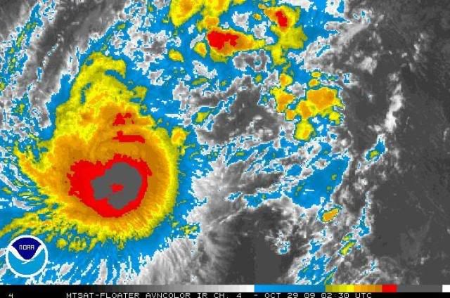
Wow! I just caught this and had to post it before I go to bed. Finally the eye is appearing on conventional satellite (IR in this case). If that is the eye, this is way south of the forecasts. Bad for Manila.
0 likes
-
drdavisjr
- Category 1
- Posts: 428
- Age: 58
- Joined: Mon Oct 12, 2009 7:07 am
- Location: Marilao, Bulacan, Philippines
- Contact:
Re: Re:
ozonepete wrote:drdavisjr wrote:oaba09 wrote:Don't worry....We have contingency plans ready
That's great! We are making our preparations today. We're making sure family and friends have secure locations to ride this baby out.
Good for you. I'm very glad to hear it. It's bedtime for me, so I'll see you all tomorrow.
Thanks ozonepete!!! Have a good rest.
0 likes
-
Aslkahuna

- Professional-Met
- Posts: 4549
- Joined: Thu Feb 06, 2003 5:00 pm
- Location: Tucson, AZ
- Contact:
Re: WPAC : TYPHOON MIRINAE (23W) PAGASA=TYPHOON SANTI
Latest from JT has landfall around 15.3N while PAGASA is still going 16.1. JT's 48 hour position has the storm at 15.3N 121.3E or 42 miles E of DMIA a with a CPA to DMIA of 9 miles. The location of the eye at its closest to DMIA is critical there since if it passes to the north the winds may not gust to 60kt while if it passes south then Cat 1 conditions at the airport of 65G75-80 kt are possible. A track further south between DMIA and Manila will probably result in gusts around 60kt at DMIA. Manila will have strong winds and heavy rainsqualls coming in from the SCS as the storm passes to the north. Typhoon force gusts at least along the sea wall and a backlash surge of 1-2m are probable. Subic will be lashed hard. Unfortunately, the actual landfall point may not be accessible if it occurs at 15.3N.
The above is based upon climatological records of storms following similar tracks with similar intensities with the tracks derived from the JTWC ATCRs and observation records and studies from Clark AB prior to 1982.
Steve
The above is based upon climatological records of storms following similar tracks with similar intensities with the tracks derived from the JTWC ATCRs and observation records and studies from Clark AB prior to 1982.
Steve
0 likes
-
StormingB81

- S2K Supporter
- Posts: 5676
- Age: 44
- Joined: Thu Aug 27, 2009 1:45 am
- Location: Rockledge, Florida
-
oaba09
- S2K Supporter
- Posts: 1496
- Age: 39
- Joined: Thu Oct 01, 2009 10:02 am
- Location: Valenzuela, Philippines
- Contact:
Re: WPAC : TYPHOON MIRINAE (23W) PAGASA=TYPHOON SANTI

<Analyses at 29/03 UTC>
Scale -
Intensity Strong
Center position N15°50'(15.8°)
E131°25'(131.4°)
Direction and speed of movement W 30km/h(15kt)
Central pressure 955hPa
Maximum wind speed near the center 40m/s(80kt)
Maximum wind gust speed 60m/s(115kt)
Area of 50kt winds or more Wide 130km(70NM)
Area of 30kt winds or more N370km(200NM)
S220km(120NM)
<Forecast for 30/03 UTC>
Intensity Strong
Center position of probability circle N15°35'(15.6°)
E125°55'(125.9°)
Direction and speed of movement W 25km/h(13kt)
Central pressure 945hPa
Maximum wind speed near the center 40m/s(80kt)
Maximum wind gust speed 60m/s(115kt)
Radius of probability circle 140km(75NM)
Storm warning area Wide 280km(150NM)
<Forecast for 31/00 UTC>
Intensity Strong
Center position of probability circle N15°30'(15.5°)
E122°05'(122.1°)
Direction and speed of movement W 20km/h(12kt)
Central pressure 950hPa
Maximum wind speed near the center 40m/s(80kt)
Maximum wind gust speed 60m/s(115kt)
Radius of probability circle 260km(140NM)
Storm warning area Wide 410km(220NM)
<Forecast for 01/00 UTC>
Intensity Strong
Center position of probability circle N15°35'(15.6°)
E116°35'(116.6°)
Direction and speed of movement W 25km/h(13kt)
Central pressure 950hPa
Maximum wind speed near the center 40m/s(80kt)
Maximum wind gust speed 60m/s(115kt)
Radius of probability circle 390km(210NM)
Storm warning area Wide 540km(290NM)
0 likes
-
dexterlabio
- Category 5

- Posts: 3519
- Joined: Sat Oct 24, 2009 11:50 pm
Re: WPAC : TYPHOON MIRINAE (23W) PAGASA=TYPHOON SANTI
so it will be less than a hundred kilometers north of manila. i'm expecting some strong winds of a cat1 typhoon to be felt here. milenyo (xangxane) made landfall in southern tip of ncr, isn't it? more in laguna and cavite area, but its rage was also felt in the northern portions of metro manila. well, this is really bad for us, especially that the hype is on the observance of all saint's day, and the threat of the storm is not that prioritized.
anyway, PAGASA still tracks mirinae in aurora-isabela area. but they had polilio islands under signal number 2. maybe they are also thinking that the typhoon is also likely to hit the island.
anyway, PAGASA still tracks mirinae in aurora-isabela area. but they had polilio islands under signal number 2. maybe they are also thinking that the typhoon is also likely to hit the island.
0 likes
Personal Forecast Disclaimer:
The posts in this forum are NOT official forecast and should not be used as such. They are just the opinion of the poster and may or may not be backed by sound meteorological data. They are NOT endorsed by any professional institution or storm2k.org. For official information, please refer to the NHC and NWS products.
The posts in this forum are NOT official forecast and should not be used as such. They are just the opinion of the poster and may or may not be backed by sound meteorological data. They are NOT endorsed by any professional institution or storm2k.org. For official information, please refer to the NHC and NWS products.
-
dexterlabio
- Category 5
- Posts: 3519
- Joined: Sat Oct 24, 2009 11:50 pm
Re:
StormingB81 wrote:On the latest radar image looks like there is a visable eye. thats not good.
what does it look like? is it a pinhole thing? i kinda remebered parma's circulation in mirinae. parma had this thick radial circulation or CDO then it had this pinhole eye formed shortly.
0 likes
Personal Forecast Disclaimer:
The posts in this forum are NOT official forecast and should not be used as such. They are just the opinion of the poster and may or may not be backed by sound meteorological data. They are NOT endorsed by any professional institution or storm2k.org. For official information, please refer to the NHC and NWS products.
The posts in this forum are NOT official forecast and should not be used as such. They are just the opinion of the poster and may or may not be backed by sound meteorological data. They are NOT endorsed by any professional institution or storm2k.org. For official information, please refer to the NHC and NWS products.
-
StormingB81
- S2K Supporter
- Posts: 5676
- Age: 44
- Joined: Thu Aug 27, 2009 1:45 am
- Location: Rockledge, Florida
-
cycloneye
- Admin
- Posts: 149751
- Age: 69
- Joined: Thu Oct 10, 2002 10:54 am
- Location: San Juan, Puerto Rico
Re: WPAC : TYPHOON MIRINAE (23W) PAGASA=TYPHOON SANTI
0 likes
Visit the Caribbean-Central America Weather Thread where you can find at first post web cams,radars
and observations from Caribbean basin members Click Here
and observations from Caribbean basin members Click Here
-
StormingB81
- S2K Supporter
- Posts: 5676
- Age: 44
- Joined: Thu Aug 27, 2009 1:45 am
- Location: Rockledge, Florida
-
StormingB81
- S2K Supporter
- Posts: 5676
- Age: 44
- Joined: Thu Aug 27, 2009 1:45 am
- Location: Rockledge, Florida
-
dexterlabio
- Category 5
- Posts: 3519
- Joined: Sat Oct 24, 2009 11:50 pm
Re: WPAC : TYPHOON MIRINAE (23W) PAGASA=TYPHOON SANTI
the center of its circulation remains tight and continues to expand. my fear was lessened a bit to know that intensification in the coming hours will be limited, but knowing that the predicted intensities of a storm always change, i am still expecting the worse case... it will still travel hundreds of miles before landfall, so anything can happen. maybe i must visit the cemetery as early as tomorrow.
0 likes
Personal Forecast Disclaimer:
The posts in this forum are NOT official forecast and should not be used as such. They are just the opinion of the poster and may or may not be backed by sound meteorological data. They are NOT endorsed by any professional institution or storm2k.org. For official information, please refer to the NHC and NWS products.
The posts in this forum are NOT official forecast and should not be used as such. They are just the opinion of the poster and may or may not be backed by sound meteorological data. They are NOT endorsed by any professional institution or storm2k.org. For official information, please refer to the NHC and NWS products.
Who is online
Users browsing this forum: No registered users and 64 guests