Coral Sea: HAMISH - Tropical Cyclone

Moderator: S2k Moderators

Message
Author
User avatar
HURAKAN
Professional-Met
Professional-Met
Posts: 46086
Age: 37
Joined: Thu May 20, 2004 4:34 pm
Location: Key West, FL
Contact:

Re: Coral Sea: HAMISH - Tropical Cyclone

#201 Postby HURAKAN » Tue Mar 10, 2009 10:25 pm

Image

WTPS31 PGTW 110300
MSGID/GENADMIN/NAVMARFCSTCEN PEARL HARBOR HI/JTWC//
SUBJ/TROPICAL CYCLONE 18P (HAMISH) WARNING NR 012//
RMKS/
1. TROPICAL CYCLONE 18P (HAMISH) WARNING NR 012
01 ACTIVE TROPICAL CYCLONE IN SOUTHPAC
MAX SUSTAINED WINDS BASED ON ONE-MINUTE AVERAGE
---
WARNING POSITION:
110000Z --- NEAR 24.2S 155.2E
MOVEMENT PAST SIX HOURS - 285 DEGREES AT 04 KTS
POSITION ACCURATE TO WITHIN 040 NM
POSITION BASED ON CENTER LOCATED BY SATELLITE
PRESENT WIND DISTRIBUTION:
MAX SUSTAINED WINDS - 050 KT, GUSTS 065 KT
WIND RADII VALID OVER OPEN WATER ONLY
RADIUS OF 034 KT WINDS - 085 NM NORTHEAST QUADRANT
085 NM SOUTHEAST QUADRANT
085 NM SOUTHWEST QUADRANT
085 NM NORTHWEST QUADRANT
REPEAT POSIT: 24.2S 155.2E
---
FORECASTS:
12 HRS, VALID AT:
111200Z --- 23.6S 154.6E
MAX SUSTAINED WINDS - 045 KT, GUSTS 055 KT
WIND RADII VALID OVER OPEN WATER ONLY
RADIUS OF 034 KT WINDS - 075 NM NORTHEAST QUADRANT
075 NM SOUTHEAST QUADRANT
075 NM SOUTHWEST QUADRANT
075 NM NORTHWEST QUADRANT
VECTOR TO 24 HR POSIT: 325 DEG/ 04 KTS
---
24 HRS, VALID AT:
120000Z --- 22.9S 154.1E
MAX SUSTAINED WINDS - 040 KT, GUSTS 050 KT
WIND RADII VALID OVER OPEN WATER ONLY
RADIUS OF 034 KT WINDS - 070 NM NORTHEAST QUADRANT
070 NM SOUTHEAST QUADRANT
070 NM SOUTHWEST QUADRANT
070 NM NORTHWEST QUADRANT
VECTOR TO 36 HR POSIT: 325 DEG/ 04 KTS
---
36 HRS, VALID AT:
121200Z --- 22.2S 153.6E
MAX SUSTAINED WINDS - 035 KT, GUSTS 045 KT
WIND RADII VALID OVER OPEN WATER ONLY
DISSIPATING AS A SIGNIFICANT TROPICAL CYCLONE OVER WATER
VECTOR TO 48 HR POSIT: 320 DEG/ 04 KTS
---
EXTENDED OUTLOOK:
48 HRS, VALID AT:
130000Z --- 21.5S 153.0E
MAX SUSTAINED WINDS - 030 KT, GUSTS 040 KT
WIND RADII VALID OVER OPEN WATER ONLY
DISSIPATED AS A SIGNIFICANT TROPICAL CYCLONE OVER WATER
---
REMARKS:
110300Z POSITION NEAR 24.0S 155.1E.
TROPICAL CYCLONE (TC) 18P (HAMISH), LOCATED APPROXIMATELY 230 NM
NORTHEAST OF BRISBANE, AUSTRALIA, HAS TRACKED WESTWARD AT 04 KNOTS
OVER THE PAST 06 HOURS. ANIMATED MULTISPECTRAL SATELLITE AND RECENT
MICROWAVE IMAGERY SHOW A FULLY EXPOSED LOW LEVEL CIRCULATION CENTER
TRACKING WESTWARD AWAY FROM THE DEEP CONVECTION WHICH IS SHEARED TO
THE EAST. THE CURRENT POSITION AND MOTION ARE BASED UPON THE
ANIMATED IMAGERY AS WELL AS A 102022Z QSCAT IMAGE. THE CURRENT
INTENSITY IS BASED ON DVORAK ESTIMATES RANGING FROM 35 TO 55 KNOTS
AND THE PREVIOUSLY MENTIONED QSCAT IMAGE. AFTER REVERSING DIRECTION
NEAR 10/12Z THE SYSTEM HAS TRACKED SLOWLY WESTWARD OVER THE PAST 12
HOURS, AND IS FORECAST TO TRACK INCREASINGLY NORTHWESTWARD UNDER THE
STEERING INFLUENCE OF A LOW- TO MID-LEVEL SUBTROPICAL RIDGE WHICH IS
BUILDING WEST AND SOUTH OF THE SYSTEM. THIS DEVELOPMENT IS EVIDENT
ON THE 10/12Z 700 MB ANALYSIS. TC 18P WILL MAINTAIN SLOW FORWARD
TRACK SPEED AS IT BATTLES COMPETING STEERING FLOW BETWEEN THE
PRIMARY INFLUENCE TO THE WEST AND SOUTH AND NORTHWESTERLY FLOW
ORIGINATING FROM A WEAKER RIDGE BUILDING TO THE NORTHEAST. TC 18P
WILL WEAKEN STEADILY OVER THE FORECAST PERIOD AND ULTIMATELY
DISSIPATE AS A SIGNIFICANT TROPICAL CYCLONE NEAR TAU 48 WHILE MOVING
NORTHWESTWARD ALONG THE AUSTRALIAN COAST. THIS FORECAST IS BASED
UPON THE MAJORITY OF DYNAMIC AIDS (WITH THE EXCEPTION OF NGPS AND
WBAR) WHICH DEPICT THE NORTHWESTERLY MOTION AND CONTINUED WEAKENING
TREND. MAXIMUM SIGNIFICANT WAVE HEIGHT AT 110000Z IS 20 FEET. NEXT
WARNINGS AT 111500Z AND 120300Z.
0 likes   

Rod Hagen
Tropical Storm
Tropical Storm
Posts: 237
Joined: Fri Sep 23, 2005 6:22 am
Location: Lives in Melbourne, works in N Queensland

#202 Postby Rod Hagen » Tue Mar 10, 2009 11:50 pm

Looks like the Australian BoM were the ones who got it right first, at least as far as the about face is concerned. There are some pretty nasty seas along the south and central Qld coast I gather.

Cheers

Rod
0 likes   

Rod Hagen
Tropical Storm
Tropical Storm
Posts: 237
Joined: Fri Sep 23, 2005 6:22 am
Location: Lives in Melbourne, works in N Queensland

#203 Postby Rod Hagen » Wed Mar 11, 2009 4:23 am

Still a cat 2 tonight, and heading north now back into warmer seas. Every now and then there seems to be a hurricane/ cyclone that just doesn't know when to quit!

Cheers

Rod
0 likes   

User avatar
Chacor
Category 5
Category 5
Posts: 10229
Joined: Mon Oct 02, 2006 10:43 pm
Location: Singapore

#204 Postby Chacor » Wed Mar 11, 2009 4:56 am

It's devoid of convective activity near the centre but we'll see how it does when it gets back nearer Cairns.
0 likes   

HurricaneRobert
Category 3
Category 3
Posts: 812
Joined: Fri May 18, 2007 9:31 pm

Re: Coral Sea: HAMISH - Tropical Cyclone

#205 Postby HurricaneRobert » Wed Mar 11, 2009 9:07 am

Looks like its gone.
0 likes   

User avatar
HURAKAN
Professional-Met
Professional-Met
Posts: 46086
Age: 37
Joined: Thu May 20, 2004 4:34 pm
Location: Key West, FL
Contact:

#206 Postby HURAKAN » Wed Mar 11, 2009 9:10 am

Image

Shear. Loved in the Mid-Latitudes, hated in the Tropics.
0 likes   

User avatar
Chacor
Category 5
Category 5
Posts: 10229
Joined: Mon Oct 02, 2006 10:43 pm
Location: Singapore

#207 Postby Chacor » Wed Mar 11, 2009 9:11 am

Brisbane has downgraded to a Tropical Low.

IDQ20018
TROPICAL CYCLONE TECHNICAL BULLETIN: AUSTRALIA - EASTERN REGION
Issued by BRISBANE TROPICAL CYCLONE WARNING CENTRE
at: 1339 UTC 11/03/2009
Name: Ex-Tropical Cyclone Hamish
Identifier: 17U
Data At: 1200 UTC
Latitude: 22.4S
Longitude: 154.8E
Location Accuracy: within 20 nm [37 km]
Movement Towards: north [355 deg]
Speed of Movement: 11 knots [20 km/h]
Maximum 10-Minute Wind: 40 knots [75 km/h]
Maximum 3-Second Wind Gust: 55 knots [100 km/h]
Central Pressure: 998 hPa
Radius of 34-knot winds NE quadrant:
Radius of 34-knot winds SE quadrant:
Radius of 34-knot winds SW quadrant: 150 nm [280 km]
Radius of 34-knot winds NW quadrant:
Radius of 48-knot winds NE quadrant:
Radius of 48-knot winds SE quadrant:
Radius of 48-knot winds SW quadrant:
Radius of 48-knot winds NW quadrant:
Radius of 64-knot winds:
Radius of Maximum Winds:
Dvorak Intensity Code: N/A
Pressure of outermost isobar: 1006 hPa
Radius of outermost closed isobar: 120 nm [220 km]
Storm Depth: Shallow
FORECAST DATA
Date/Time : Location : Loc. Accuracy: Max Wind : Central Pressure
[UTC] : degrees : nm [km]: knots[km/h]: hPa
+12: 12/0000: 21.4S 153.1E: 045 [085]: 035 [065]: 1002
+24: 12/1200: 20.5S 151.8E: 075 [140]: 030 [055]: 1004
+36: 13/0000: 20.0S 151.2E: 110 [200]: 030 [055]: 1005
+48: 13/1200: 19.6S 150.7E: 140 [260]: 025 [045]: 1006
+60: 14/0000: 18.5S 149.3E: 190 [350]: 025 [045]: 1006
+72: 14/1200: 16.7S 147.7E: 225 [415]: 025 [045]: 1006
REMARKS:
Position good utilising enhanced IR imagery, quikscat and peripheral surface
observations. Recent NNW movement as low level centre is influenced by the ridge
to the south. Expect NW motion to continue for 24 to 48 hours. Dvorak MET would
give FT 3.5, constraints broken with good observational evidence.


Copyright Commonwealth of Australia
==
No further technical bulletins will be issued for this system unless it
regenerates.
0 likes   

User avatar
HURAKAN
Professional-Met
Professional-Met
Posts: 46086
Age: 37
Joined: Thu May 20, 2004 4:34 pm
Location: Key West, FL
Contact:

#208 Postby HURAKAN » Wed Mar 11, 2009 6:16 pm

Image

Shear too harsh on Hamish.
0 likes   

User avatar
Ptarmigan
Category 5
Category 5
Posts: 5273
Joined: Wed Aug 16, 2006 9:06 pm

Re: Coral Sea: HAMISH - Tropical Cyclone

#209 Postby Ptarmigan » Wed Mar 11, 2009 8:13 pm

The mighty have fallen. Good riddance Hamish!
:grrr: :grrr: :grrr: :grrr:
0 likes   

Squarethecircle
Category 5
Category 5
Posts: 2165
Joined: Fri Oct 19, 2007 4:00 pm
Location: Fairfax, VA

#210 Postby Squarethecircle » Wed Mar 11, 2009 8:30 pm

Hamish never hurt anyone (fatally)! He was beautiful in his own special way. : P
0 likes   

HurricaneRobert
Category 3
Category 3
Posts: 812
Joined: Fri May 18, 2007 9:31 pm

Re: Coral Sea: HAMISH - Tropical Cyclone

#211 Postby HurricaneRobert » Wed Mar 11, 2009 8:57 pm

I thought they were in a drought there, so this may have helped them.
0 likes   

User avatar
Chacor
Category 5
Category 5
Posts: 10229
Joined: Mon Oct 02, 2006 10:43 pm
Location: Singapore

#212 Postby Chacor » Wed Mar 11, 2009 9:40 pm

Drought is further down south I think.
0 likes   

User avatar
HURAKAN
Professional-Met
Professional-Met
Posts: 46086
Age: 37
Joined: Thu May 20, 2004 4:34 pm
Location: Key West, FL
Contact:

#213 Postby HURAKAN » Wed Mar 11, 2009 10:40 pm

Image

WTPS31 PGTW 120300
MSGID/GENADMIN/NAVMARFCSTCEN PEARL HARBOR HI/JTWC//
SUBJ/TROPICAL CYCLONE 18P (HAMISH) WARNING NR 014//
RMKS/
1. TROPICAL CYCLONE 18P (HAMISH) WARNING NR 014
02 ACTIVE TROPICAL CYCLONES IN SOUTHPAC
MAX SUSTAINED WINDS BASED ON ONE-MINUTE AVERAGE
---
WARNING POSITION:
120000Z --- NEAR 21.8S 152.7E
MOVEMENT PAST SIX HOURS - 275 DEGREES AT 09 KTS
POSITION ACCURATE TO WITHIN 040 NM
POSITION BASED ON CENTER LOCATED BY SATELLITE
PRESENT WIND DISTRIBUTION:
MAX SUSTAINED WINDS - 025 KT, GUSTS 035 KT
WIND RADII VALID OVER OPEN WATER ONLY
DISSIPATING AS A SIGNIFICANT TROPICAL CYCLONE OVER WATER
REPEAT POSIT: 21.8S 152.7E
---
FORECASTS:
12 HRS, VALID AT:
121200Z --- 21.4S 151.6E
MAX SUSTAINED WINDS - 020 KT, GUSTS 030 KT
WIND RADII VALID OVER OPEN WATER ONLY
DISSIPATED AS A SIGNIFICANT TROPICAL CYCLONE OVER WATER
VECTOR TO 24 HR POSIT: 295 DEG/ 06 KTS
---
24 HRS, VALID AT:
130000Z --- 20.9S 150.5E
MAX SUSTAINED WINDS - 015 KT, GUSTS 025 KT
WIND RADII VALID OVER OPEN WATER ONLY
DISSIPATED AS A SIGNIFICANT TROPICAL CYCLONE OVER WATER
---
REMARKS:
120300Z POSITION NEAR 21.7S 152.4E.
TROPICAL CYCLONE (TC) 18P (HAMISH), LOCATED APPROXIMATELY 485 NM
SOUTHEAST OF CAIRNS, AUSTRALIA, HAS TRACKED WESTWARD AT 09 KNOTS
OVER THE PAST 06 HOURS. ANIMATED MULTISPECTRAL SATELLITE IMAGERY DE-
PICTS A FULLY-EXPOSED LOW-LEVEL CIRCULATION CENTER (LLCC) WITH NO
ASSOCIATED DEEP CONVECTION. AN 111956Z QUIKSCAT PASS INDICATES THAT
THE LLCC HAS CONTINUED TO WEAKEN AND BECOME LESS ORGANIZED OVER THE
PAST 12 HOURS. HIGH LEVELS OF VERTICAL WIND SHEAR AND INTERACTION
WITH LAND WILL QUICKLY CAUSE THE LLCC TO DISSIPATE BY TAU 24. THE
QUIKSCAT PASS INDICATES STRONGEST WINDS ARE IN THE SOUTHWESTERN
QUADRANT OF THE LLCC AT 20-25 KNOTS. BASED ON THE QUIKSCAT PASS AND
THE HIGH VERTICAL WIND SHEAR NO FURTHER INTENSIFICATION OF TC 18P IS
EXPECTED PRIOR TO LANDFALL. THIS IS THE FINAL WARNING ON THIS SYSTEM
BY THE JOINT TYPHOON WARNING CENTER (NAVMARFCSTCEN). THE SYSTEM WILL
BE CLOSELY MONITORED FOR SIGNS OF REGENERATION. MAXIMUM SIGNIFICANT
WAVE HEIGHT AT 120000Z IS 16 FEET. REFER TO TROPICAL CYCLONE 20P
(JONI) WARNINGS (WTPS32 PGTW) FOR TWELVE-HOURLY UPDATES.//
0 likes   

Rod Hagen
Tropical Storm
Tropical Storm
Posts: 237
Joined: Fri Sep 23, 2005 6:22 am
Location: Lives in Melbourne, works in N Queensland

Re:

#214 Postby Rod Hagen » Thu Mar 12, 2009 4:52 am

Squarethecircle wrote:Hamish never hurt anyone (fatally)! He was beautiful in his own special way. : P


Well it seems to have killed two people on a fishing trawler caught by it, I'm afraid. Another guy survived due to remarkable good luck. see http://www.abc.net.au/news/stories/2009 ... 513737.htm

Cheers

Rod
0 likes   

Rod Hagen
Tropical Storm
Tropical Storm
Posts: 237
Joined: Fri Sep 23, 2005 6:22 am
Location: Lives in Melbourne, works in N Queensland

Re:

#215 Postby Rod Hagen » Thu Mar 12, 2009 5:01 am

Chacor wrote:Drought is further down south I think.


It is a difficult mix, Chacor. The worst droughts (and the fires) have been in the south - in Victoria , Southern NSW and SA , more than a thousand miles from Hamish. But there have been some serious shortfalls in rainfall in some parts of Qld too. At present we are getting the whole gamut - droughts, floods, extreme temps, big cyclones well south of their usual habitat (like Hamish), etc , etc. . The weather is tough in Australia at present! The extremes are at the extreme outliers of experience here, even though this can be a harsh country at the best of times. Whether this is the new "state of the world" because of "climate change" or the like, who knows? Whatever, the picture isn't pretty if you live here!

Cheers

Rod
0 likes   

User avatar
somethingfunny
ChatStaff
ChatStaff
Posts: 3926
Age: 35
Joined: Thu May 31, 2007 10:30 pm
Location: McKinney, Texas

Re: Coral Sea: HAMISH - Tropical Cyclone

#216 Postby somethingfunny » Fri Mar 13, 2009 2:03 pm

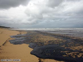
Australia declares disaster over oil spill

(CNN) -- Australian authorities have declared several coastal areas near Brisbane disaster zones after a massive oil spill earlier this week, according to the Queensland government.

"This is a very serious situation," Queensland Premier Anna Bligh said, according to a news release on Friday. "It appears the volume of oil involved is much greater than originally reported by the Pacific Adventurer. And the effect of the oil spill is more widespread."

The Pacific Adventurer sustained damage early Wednesday when Cyclone Hamish struck the waters of eastern Australia with more than 125 kph (77 mph) winds. The cargo ship lost 30 of its 50 containers of ammonium nitrate about 13 kilometers (8 miles) off the coast of Cape Moreton. Those containers are still missing.

The damaged ship also spilled a large amount of oil that is covering at least 60 kilometers (37 miles) of beach in and around Brisbane, according to Australian Broadcasting Corporation (ABC). Watch sludge washing up on shorelines »

The ship's owner, Swire Shipping, initially said no more than 42,000 liters (11,100 U.S. gallons) of oil escaped from the ship, but now says that "substantially more oil was spilled," ABC reported Friday.

The ship is currently in the custody of Australia's Maritime Safety Authority in Brisbane, as the investigation into the spill continues.

A massive clean-up effort is also under way. So far, 13 oil-covered birds have been recovered, according to the Queensland government.

Image
0 likes   


Return to “2009”

Who is online

Users browsing this forum: No registered users and 106 guests