WTPS31 PGTW 090300
MSGID/GENADMIN/NAVMARFCSTCEN PEARL HARBOR HI/JTWC//
SUBJ/TROPICAL CYCLONE 18P (HAMISH) WARNING NR 008//
RMKS/
1. TROPICAL CYCLONE 18P (HAMISH) WARNING NR 008
01 ACTIVE TROPICAL CYCLONE IN SOUTHPAC
MAX SUSTAINED WINDS BASED ON ONE-MINUTE AVERAGE
---
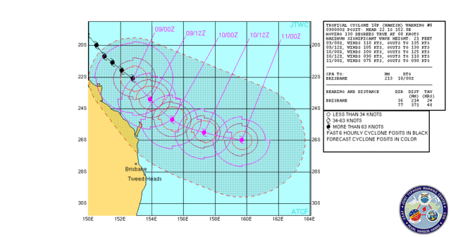
WARNING POSITION:
090000Z --- NEAR 22.1S 152.8E
MOVEMENT PAST SIX HOURS - 130 DEGREES AT 08 KTS
POSITION ACCURATE TO WITHIN 020 NM
POSITION BASED ON CENTER LOCATED BY SATELLITE
PRESENT WIND DISTRIBUTION:
MAX SUSTAINED WINDS - 110 KT, GUSTS 135 KT
WIND RADII VALID OVER OPEN WATER ONLY
RADIUS OF 064 KT WINDS - 050 NM NORTHEAST QUADRANT
050 NM SOUTHEAST QUADRANT
045 NM SOUTHWEST QUADRANT
045 NM NORTHWEST QUADRANT
RADIUS OF 050 KT WINDS - 080 NM NORTHEAST QUADRANT
080 NM SOUTHEAST QUADRANT
070 NM SOUTHWEST QUADRANT
070 NM NORTHWEST QUADRANT
RADIUS OF 034 KT WINDS - 140 NM NORTHEAST QUADRANT
140 NM SOUTHEAST QUADRANT
130 NM SOUTHWEST QUADRANT
135 NM NORTHWEST QUADRANT
REPEAT POSIT: 22.1S 152.8E
---
FORECASTS:
12 HRS, VALID AT:
091200Z --- 23.4S 153.9E
MAX SUSTAINED WINDS - 105 KT, GUSTS 130 KT
WIND RADII VALID OVER OPEN WATER ONLY
RADIUS OF 064 KT WINDS - 050 NM NORTHEAST QUADRANT
045 NM SOUTHEAST QUADRANT
040 NM SOUTHWEST QUADRANT
050 NM NORTHWEST QUADRANT
RADIUS OF 050 KT WINDS - 070 NM NORTHEAST QUADRANT
070 NM SOUTHEAST QUADRANT
070 NM SOUTHWEST QUADRANT
075 NM NORTHWEST QUADRANT
RADIUS OF 034 KT WINDS - 090 NM NORTHEAST QUADRANT
105 NM SOUTHEAST QUADRANT
115 NM SOUTHWEST QUADRANT
100 NM NORTHWEST QUADRANT
VECTOR TO 24 HR POSIT: 135 DEG/ 09 KTS
---
24 HRS, VALID AT:
100000Z --- 24.7S 155.3E
MAX SUSTAINED WINDS - 100 KT, GUSTS 125 KT
WIND RADII VALID OVER OPEN WATER ONLY
RADIUS OF 064 KT WINDS - 050 NM NORTHEAST QUADRANT
045 NM SOUTHEAST QUADRANT
040 NM SOUTHWEST QUADRANT
050 NM NORTHWEST QUADRANT
RADIUS OF 050 KT WINDS - 065 NM NORTHEAST QUADRANT
065 NM SOUTHEAST QUADRANT
065 NM SOUTHWEST QUADRANT
070 NM NORTHWEST QUADRANT
RADIUS OF 034 KT WINDS - 085 NM NORTHEAST QUADRANT
100 NM SOUTHEAST QUADRANT
110 NM SOUTHWEST QUADRANT
095 NM NORTHWEST QUADRANT
VECTOR TO 36 HR POSIT: 115 DEG/ 10 KTS
---
36 HRS, VALID AT:
101200Z --- 25.5S 157.3E
MAX SUSTAINED WINDS - 090 KT, GUSTS 110 KT
WIND RADII VALID OVER OPEN WATER ONLY
RADIUS OF 064 KT WINDS - 045 NM NORTHEAST QUADRANT
040 NM SOUTHEAST QUADRANT
035 NM SOUTHWEST QUADRANT
045 NM NORTHWEST QUADRANT
RADIUS OF 050 KT WINDS - 055 NM NORTHEAST QUADRANT
055 NM SOUTHEAST QUADRANT
060 NM SOUTHWEST QUADRANT
065 NM NORTHWEST QUADRANT
RADIUS OF 034 KT WINDS - 080 NM NORTHEAST QUADRANT
095 NM SOUTHEAST QUADRANT
100 NM SOUTHWEST QUADRANT
090 NM NORTHWEST QUADRANT
VECTOR TO 48 HR POSIT: 105 DEG/ 11 KTS
---
EXTENDED OUTLOOK:
48 HRS, VALID AT:
110000Z --- 26.0S 159.7E
MAX SUSTAINED WINDS - 075 KT, GUSTS 090 KT
WIND RADII VALID OVER OPEN WATER ONLY
RADIUS OF 064 KT WINDS - 035 NM NORTHEAST QUADRANT
035 NM SOUTHEAST QUADRANT
035 NM SOUTHWEST QUADRANT
035 NM NORTHWEST QUADRANT
RADIUS OF 050 KT WINDS - 055 NM NORTHEAST QUADRANT
055 NM SOUTHEAST QUADRANT
060 NM SOUTHWEST QUADRANT
065 NM NORTHWEST QUADRANT
RADIUS OF 034 KT WINDS - 080 NM NORTHEAST QUADRANT
095 NM SOUTHEAST QUADRANT
100 NM SOUTHWEST QUADRANT
090 NM NORTHWEST QUADRANT
---
REMARKS:
090300Z POSITION NEAR 22.4S 153.1E.
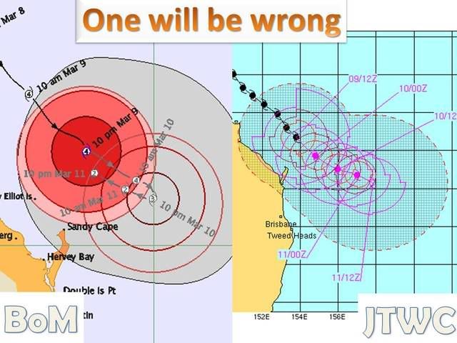
TROPICAL CYCLONE (TC) 18P (HAMISH), LOCATED APPROXIMATELY 320 NM
NORTH OF BRISBANE, AUSTRALIA, HAS TRACKED SOUTHEASTWARD AT 08 KNOTS
OVER THE PAST 06 HOURS. TC 18P HAS BEGUN TO SHOW SIGNS OF WEAKENING
OVER THE PAST 12 HOURS. DVORAK SATELLITE ESTIMATES FROM PGTW AND
ABRF AGREE WITH A 102 KNOT SYSTEM. ANIMATED SATELLITE IMAGERY SHOWS
AN ENLARGING EYE WITH EXPANDING UPPER LEVEL CLOUD COVER. THE TRACK
IS FORECAST TO TURN EASTWARD AS TC 18P MOVES AROUND THE MID-LEVEL
SUBTROPICAL RIDGE EAST OF TC 18P. INCREASED INTERACTION WITH THE MID-
LATITUDE FLOW WILL BEGIN TO WEAKEN THE SYSTEM THROUGHOUT THE
FORECAST PERIOD, BUT TC 18P WILL REMAIN FAIRLY INTENSE THROUGH TAU
48. SEA SURFACE TEMPERATURES WILL DECREASE THROUGH THE FORECAST
ADVERSELY AFFECTING THE LLCC. MAXIMUM SIGNIFICANT WAVE HEIGHT AT
090000Z IS 21 FEET. NEXT WARNINGS AT 091500Z AND 100300Z.//
NNNN